

Oklahoma map
Tulsa map
About 415,154 people live here (Census Bureau, 2024 estimate). The sheet's index lists 134 streets; East 46th Street North, Pearl Harbor Memorial Expressway and Martin Luther King, Junior Memorial Expressway cross the most grid squares. Things to do inside the boundary: Bob Dylan Center, Cain's Ballroom and Gathering Place.
Open the map (PDF, US Letter)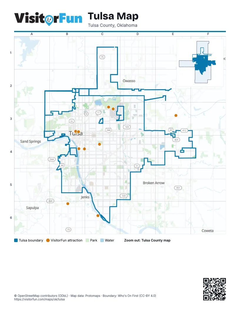
Street index of Tulsa
Each street on the sheet and the grid squares it crosses.
- North Peoria Avenue EastB2, B3
- Chapelle Family Memorial HighwayC2, B3, C3
- Cherokee ExpresswayC2
- North Lewis Avenue EastC2, C3
- East 46th Street NorthD2, B3, C3, D3
- Pearl Harbor Memorial ExpresswayD2, D3, D4, D5
- 42nd "Rainbow" Infantry Division Memorial HighwayB3
- East 1st Street SouthB3, C3
- East 2nd Street SouthB3
- East 36th Street NorthB3, C3, D3
- East 4th Street SouthB3, B4
- East Admiral Boulevard NorthB3, C3
- East Apache StreetB3, C3
- East Apache Street NorthB3, C3
- East Pine Street NorthB3, C3
- Gilcrease ExpresswayB3, C3, B4
- Inner Dispersal LoopB3, B4
- L. L. Tisdale ParkwayB3
- Martin Luther King Junior Memorial BridgeB3
- Martin Luther King, Junior Memorial ExpresswayB3, C3, D3, B4
- North 33rd Avenue WestB3
- North Denver Avenue WestB3
- North Detroit Avenue EastB3
- North Gilcrease Museum RoadB3
- North Martin Luther King, Junior Boulevard EastB3
- Paul Harvey Memorial ExpresswayB3, B4
- Sand Springs ExpresswayB3, A4
- South Cheyenne Avenue WestB3, B4
- South Cincinnati Avenue EastB3, B4
- South Denver Avenue WestB3, B4
- South Detroit Avenue EastB3, B4
- South Gilcrease Museum RoadB3, B4
- South Peoria Avenue EastB3, B4, B5
- West 1st Street SouthB3
- West 2nd Street SouthB3
- West 36th Street NorthB3
- West Edison Street NorthB3
- Airport DriveC3
- East Admiral Boulevard SouthC3
- East Admiral PlaceC3, D3
- East Admiral Place NorthC3, D3
- East Admiral Place SouthC3, D3
- East Port Road NorthC3
- East Virgin Street NorthC3
- Howard Bell Memorial BridgeC3
- North Harvard Avenue EastC3
- North Memorial Drive EastC3
- North Sheridan Road EastC3
- North Utica Avenue EastC3
- North Yale Avenue EastC3
- Private First Class Albert E. Schwab, Medal of Honor Memorial HighwayC3
- South Harvard Avenue EastC3, C4, C5
- South Lewis Avenue EastC3, C4, C5
- South Memorial Drive EastC3, C4, C5
- South Sheridan Road EastC3, C4, C5
- South Utica Avenue EastC3, C4
- South Yale Avenue EastC3, C4, C5
- Cyrus Avery CircleD3
- East Skelly Drive SouthD3, B4, C4, D4
- North 129th Avenue EastD3
- North Mingo Road EastD3
- Sergeant Jeffrey Lee Drake Memorial HighwayD3
- Skelly BypassD3, B4, C4, D4
- South 129th Avenue EastD3, D4
- South Mingo Road EastD3, D4, D5
- North 193rd Avenue EastE3
- North 193rd East AvenueE3, E4
- West Charles Page BoulevardA4, B4
- Broken Arrow ExpresswayB4, C4, D4
- Charles Page BoulevardB4
- East 10th Street SouthB4
- East 11th Street SouthB4, C4, D4, E4
- East 15th StreetB4, C4
- East 15th Street SouthB4, C4
- East 18th StreetB4
- East 21st Street SouthB4, C4, D4
- East 31st Street SouthB4, C4, D4
- East 41st Street SouthB4, C4, D4
- East 7th StreetB4
- East 7th Street SouthB4
- East 8th Street SouthB4
- East Skelly DriveB4, C4
- Okmulgee ExpresswayB4, B5
- Riverside DriveB4, B5
- Riverside ParkwayB4, B5, C5, C6
- South 33rd Avenue WestB4, B5
- South Boulder Avenue WestB4
- South Boulder Park DriveB4
- South Denver AvenueB4
- South Frisco AvenueB4
- South Houston Avenue WestB4
- South Lawton Avenue WestB4
- South Main StreetB4
- South Tacoma Avenue WestB4
- Southwest BoulevardB4
- Vietnam Veterans Memorial BridgeB4
- West 10th StreetB4
- West 11th Street SouthB4
- West 12th StreetB4
- West 12th Street SouthB4
- West 13th StreetB4
- West 13th Street SouthB4
- West 15th Street SouthB4
- West 21st Street SouthB4
- West 23rd Street SouthB4
- West 3rd Street SouthB4
- West 40th PlaceB4
- West 41st StreetB4
- West 41st Street SouthB4
- West 4th Street SouthB4
- West 7th StreetB4
- West 7th Street SouthB4
- West 8th StreetB4
- West 8th Street SouthB4
- East 51st Street SouthC4, D4
- South Delaware Avenue EastC4, C5
- South Memorial DriveC4
- South Sheridan RoadC4
- North Aspen Avenue WestD4
- Representative Sue Tibbs Memorial HighwayD4
- South Garnett Road EastD4
- West Omaha StreetD4
- Creek TurnpikeE4, C5, D5
- Will Rogers TurnpikeE4
- 71st Street SouthB5
- East 61st Street SouthB5, C5, D5
- East 71st Street SouthB5, C5, D5
- West 71st Street SouthB5
- E. G. Featherston, Junior Memorial BridgeC5
- East 81st Street SouthC5, D5
- East 91st Street SouthC5, D5
- East 96th Street SouthC5
- Corporal Jared Shoemaker Memorial BridgeD5
- East 121st Street SouthC6
Things to do on the Tulsa map
Places on the map
- Admiral Twin Drive-In
- Advanced Workzone Services
- All Star Sports Complex
- Apache Manor
- Arkansas River
- Ashton Creek
- Ashton Woods
- Audobon Park
- B. S. Roberts Park
- Bandon Trails Apartments
- Beeline Loop
- Benchmark
- Bill Knight Ford
- Blue Dome District
- Braden Park
- Braniff Park West
- Bren-Rose
- Briarglen
- Briarwood
- Bristol Park Apartments
- Brookwood
- Brookwood II
- Calvary Cemetery
- Camelot Park
- Cedar Ridge Park
- Cedar Ridge Village
- Cedarcrest
- Cedarcrest II
- Centennial Plaza
- Center Gate Business Park
- Cherry Creek Lift Station
- Cherry Hill Park
- Church On the Move
- Corporate Woods
- Costco
- Cousins Park
- Creekwood Apartment Homes
- Crescent
- Crescent Heights
- Crossings at Oakbrook
Next to Tulsa
- Broken Arrow
- Claremore
- Coweta
- Jenks
- Owasso
- Sand Springs
- Sapulpa
© OpenStreetMap contributors (ODbL) · Map data: Protomaps · Boundary: Who's On First (CC-BY 4.0)