

Oregon map
Albany map
About 57,156 people live here (Census Bureau, 2024 estimate). The sheet's index lists 300 streets; Pacific Boulevard Southwest, Columbus Street Southeast and Hill Street Southeast cross the most grid squares. Things to do inside the boundary: Albany Historic Carousel and Museum and Gallery Calapooia.
Open the map (PDF, US Letter)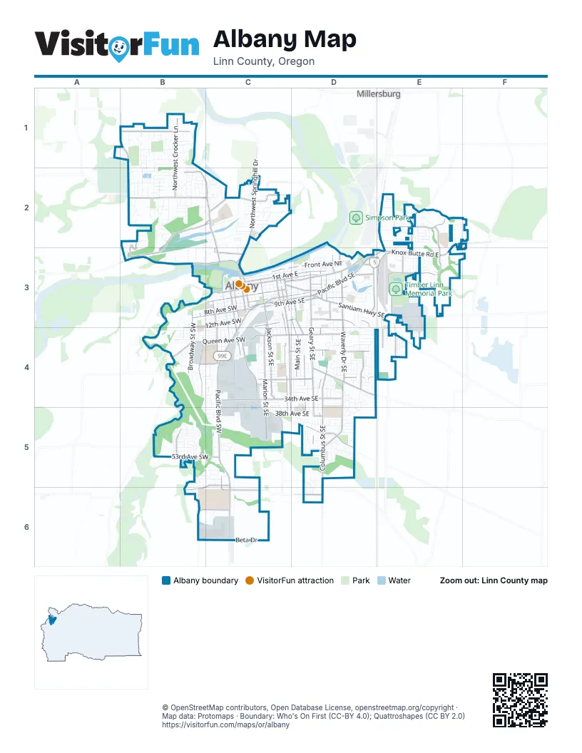
Street index of Albany
Each street on the sheet and the grid squares it crosses.
- Highway #001MR - Santiam Highway Connection #1E3
- Highway #001MT - Santiam Highway Connection #3D3
- Highway #001MU - Santiam Highway Connection #4D3
- Highway #001MS - Santiam Highway Connection #2E3
- Highway #001MW - North Albany Connection #1E3
- Highway #001MY - North Albany Connection #3E3
- Pacific Boulevard SouthwestC3, C4, C5, C6
- Albany-Corvallis HighwayB3, C3
- Pacific Boulevard SoutheastC3, D3
- Santiam Highway SoutheastD3, E3
- Northwest Springhill DriveC2, C3
- 9th Avenue SoutheastC3, D3
- Albany-Junction City HighwayD3, C6
- Ellsworth Street Southwest / Albany-Corvallis HighwayC3
- Lyon Street South / Albany-Corvallis HighwayC3
- 9th Avenue Southwest / Albany-Corvallis HighwayC3
- Ellsworth Street SouthwestC3
- Ellsworth Street Northwest / Albany-Corvallis HighwayC3
- Waverly Drive SoutheastD3, D4, D5
- Geary Street SoutheastD3, D4, D5
- Columbus Street SoutheastD3, D4, D5, D6
- Northwest Scenic DriveB1, B2, B3
- Northwest North Albany RoadB2, C2, C3
- Main Street SoutheastC3, D3, D4
- Queen Avenue SouthwestB4, C4
- Knox Butte Road EastE2, E3
- Queen Avenue SoutheastC4, D4
- Salem Avenue SoutheastC3, D3
- Northwest Gibson Hill RoadB2, C2
- 34th Avenue SoutheastC4, D4
- 1st Avenue EastC3, D3
- 2nd Avenue SoutheastC3, D3
- Grand Prairie Road SoutheastD4
- Goldfish Farm Road SoutheastE3, E4
- Burkhart Street SoutheastD3, D4, D5
- 34th Avenue SouthwestC4
- Spicer Drive SoutheastE3, E4
- Santiam Road SoutheastC3, D3
- Three Lakes Road SoutheastE4
- 2nd Avenue SouthwestC3
- 1st Avenue WestC3
- North Albany Interchange ConnectionD3, E3
- Waverly DriveD5
- North Albany ConnectionD3, E3
- Albany AvenueD3
- Hill Street SoutheastC3, C4, C5, D5
- Jackson Street SoutheastC3, C4
- Marion Street SoutheastC3, C4, C5
- Ferry Street SouthwestC3, C4
- Madison Street SoutheastC3, C4, C5
- Northwest West Thornton Lake DriveB2, C2, B3
- Oak Street SoutheastD3, D4, D5
- 14th Avenue SoutheastC3, D3
- Northwest Crocker LaneB1, B2
- 28th Avenue SoutheastC4, D4
- Northwest Valley View DriveB1
- Front Avenue NortheastC3, D3
- Liberty Street SouthwestB3, B4
- Washington Street SouthwestC3, C4
- Broadway Street SouthwestB3, B4
- Elm Street SouthwestC3, C4
- 12th Avenue SouthwestB3, C3, B4
- Price Road SoutheastE3
- Airport Road SoutheastD3
- 7th Avenue SoutheastC3, D3
- Del Rio Avenue SoutheastD5
- 9th Avenue SouthwestB3, C3
- Timber Ridge Street NortheastE2, E3
- 5th Avenue SoutheastC3, D3
- Ellingson Road SoutheastD6
- Somerset Drive NortheastE2
- Northwest Quarry RoadC2
- Lochner Road SoutheastC5
- 53rd Avenue SouthwestB5, C5
- 21st Avenue SoutheastC4, D4
- Clover Ridge Road NortheastE2, E3
- Belmont Avenue SouthwestC5, B6
- Ellingson Road SouthwestC6
- Northeast South Nebergall LoopC2
- Lexington Street SoutheastD4
- 5th Avenue SouthwestC3
- Aviation Way SoutheastE3
- Dogwood Avenue SoutheastE3
- Southwest Allen LaneB6, C6
- Northwest Hickory StreetC3
- Chinook Drive SouthwestB5
- Timber Street SoutheastE3, E4
- 3rd Avenue SouthwestC3
- Century Drive NortheastE2, E3
- 24th Avenue SouthwestB4, C4
- Killdeer Avenue SoutheastD3
- Fescue Street SoutheastE4
- Davidson Street NortheastD3
- Southeast Clay StreetD3
- Lanier Street SouthwestC5, C6
- Waverly Drive NortheastD3
- 39th Avenue SoutheastD5
- Bryant Drive SouthwestC3
- Northeast North Nebergall LoopC2
- SW Bryant WayC3
- Scenic Drive NorthwestB3
- Northwest Oak Grove DriveB2
- Water Avenue NortheastC3, D3
- Ermine Street SoutheastD3, D4, D5
- Thurston Street SoutheastC3, C4, C5
- 27th Avenue SoutheastC4, D4
- Calapooia Street SouthwestC3, C4
- Tudor Way SoutheastC3, D4, D5
- Davidson Street SoutheastD3, D4, D5
- 8th Avenue SouthwestB3, C3
- 24th Avenue SoutheastC4, D4
- Jefferson Street SoutheastC3, C4
- Walnut Street SouthwestC3, C4
- 16th Avenue SoutheastD3, C4, D4
- Chicago Street SoutheastD3, D4, D5
- 4th Avenue SoutheastC3, D3
- 20th Avenue SoutheastC4, D4
- Priv RoadE4
- Vine Street SouthwestC3, C4
- 7th Avenue SouthwestB3, C3
- Lafayette Street SoutheastC3, C4, C5
- 6th Avenue SoutheastC3, D3
- 15th Avenue SouthwestB4, C4
- Pine Street SoutheastD3, D4, D5
- 18th Avenue SoutheastC4, D4, E4
- Moraga Avenue SoutheastD5
- 13th Avenue SouthwestB3, B4, C4
- Sherman Street SoutheastC3, D3, D4
- 38th Avenue SoutheastC4, C5, D5
- Maple Street SouthwestC3, C4
- 31st Avenue SoutheastC4, D4
- 14th Avenue SouthwestB4, C4
- 25th Avenue SoutheastC4, D4
- Northwest Laura Vista DriveB1, B2
- Takena Street SouthwestB3, C3, B4, C4
- 13th Avenue SoutheastC3, D3
- Clay Street SoutheastD3, D4, D5
- Lawnridge Street SouthwestB3, B4
- Shortridge Street SoutheastD3, D5
- 23rd Avenue SoutheastC4, D4
- 30th Avenue SoutheastC4, D4
- Northwest Sunny LaneB1, B2
- 11th Avenue SouthwestB3, C3
- Northwest Grandview DriveB1, B2
- Northwest Dover LaneB2
- 6th Avenue SouthwestC3
- Northwest Broadway StreetB1, B2
- 29th Avenue SoutheastC4, D4
- 3rd Avenue SoutheastC3
- Center Street SoutheastD3, D4
- Umatilla Street SouthwestC3, C4
- Fulton Street SoutheastD3, D4
- Dunlap Avenue NortheastE2
- 16th Avenue SouthwestB4, C4
- Boston Street SoutheastD4
- Blue Ox Rv Park SoutheastE3
- 10th Avenue SouthwestB3, C3
- Newport Way SoutheastD5
- Beta DriveC6
- 29th Avenue SouthwestB4, C4
- Bain Street SoutheastD3, D4
- Northeast 13th AvenueC2
- Northwest Edgewood DriveB2
- 32nd Avenue SoutheastC4, D4
- 19th Avenue SoutheastC4, D4
- Northwest 23rd AvenueB2
- South Shore Drive SoutheastD3
- Willetta Street SouthwestC3, C4, C5
- 47th Avenue SoutheastD5
- Elk Run Drive SouthwestB5
- 15th Avenue SoutheastC3, D3, C4, D4
- 36th Avenue SoutheastC4, D4
- Cascade Drive SoutheastD5
- Northwest Cascade Heights DriveB2, C2
- Railroad Street SoutheastC3, C4
- Park Terrace SouthwestB4
- 4th Avenue SouthwestC3
- Northwest Squire StreetB1
- Montgomery Street SoutheastC3
- Blue Ox Drive SoutheastE3
- Windy Avenue NortheastE2
- Northwest Violet AvenueB1, B2, C2
- 17th Avenue SoutheastD4
- Morse Lane SouthwestB5, C5
- Pine Meadow Drive SoutheastD4
- Marten Avenue SouthwestB5
- Magnolia Way SoutheastD5
- 41st Avenue SoutheastC5, D5
- 22nd Avenue SoutheastC4, D4
- 25th Avenue SouthwestB4, C4
- Northwest Pineview DriveB1
- Northwest Pulver LaneB2
- Chase Loop SouthwestB4
- Industrial Way SouthwestC3, C4
- Willamette Avenue NortheastD3
- Northwest Jones AvenueB2, C2
- Northwest Shady LaneC2
- 26th Avenue SoutheastC4, D4
- Northwest North Heights DriveB2
- Northeast Mayview DriveC2
- Northwest Crittenden LoopB2
- Hillcrest Street NorthwestB1
- Bobcat Avenue SouthwestB5
- Northeast Cherry LaneC2
- Broadalbin Street SouthwestC3
- Northwest Essex AvenueB2
- Mount Vernon Street SoutheastD4
- Looney Lane SouthwestB5, B6
- 36th Avenue SouthwestB5, C5
- Fir Oaks Drive SouthwestB4, C4
- Northwest Horseshoe Lake CircleC2
- Lincoln Street SouthwestB3, B4
- Lehigh Way SoutheastD3, D4
- Northwest East Thornton Lake DriveC2
- Cougar Avenue SouthwestB5
- Casting Street SoutheastE3, E4
- Northwest Skyline DriveB2
- Breezy Way NortheastE2
- Collingwood Street SoutheastD4
- Salmon Run SouthwestB5
- Logan Parkway SoutheastD5
- Northwest Imperial DriveB2
- Northwest San Pedro AvenueB1
- Lyon StreetC4
- Northwest Penny LaneB2
- Northwest Green Acres LaneC2
- Northwest Oak Grove LoopA1, B1
- 8th Avenue SoutheastC3, D3
- Whirlwind Drive NortheastE2
- Expo Parkway NortheastE2, E3
- Cleveland Street SoutheastD3
- 40th Avenue SoutheastD5
- Northwest Whitmore DriveB2
- Northwest Robin Hood StreetB1
- Antelope Circle SouthwestB5
- Lakewood Drive SouthwestB4, C4
- 35th Avenue SoutheastC4, D4
- East Mountain View Drive SoutheastD4, D5
- Gale Street NorthwestB1, B2
- Black Bear Avenue SouthwestB5
- Santa Maria Avenue NortheastE2, F2
- Water Avenue NorthwestC3
- 12th Avenue SoutheastC3, D3
- Northwest Bloom LaneB1
- Charlotte Street NortheastE2
- Edgemont Street SoutheastD4
- Oakmont Loop NortheastE2
- Waterford Street SoutheastD4
- Elk Circle SouthwestB5
- Northwest Walker LaneB3
- Lyon Street SoutheastC4
- Northwest Thorn DriveB2
- Marilyn Street NortheastE2
- Northwest Olivia CircleB2, C2
- Cluster Oak AvenueB1
- Henshaw StreetD5, D6
- Oakwood Avenue SoutheastD3
- Northwest Spencer Mount DriveB2, C2
- Brookside Avenue SoutheastD4
- 22nd Avenue SouthwestC4
- 33rd Avenue SoutheastC4, D4
- Sagecrest Drive NortheastE2
- Trinity Street NortheastE2
- Wallace WayC5
- Baker Street SoutheastC3
- Northwest Ravenwood DriveB2
- 28th Avenue SouthwestB4, C4
- Northeast Sherman StreetC2
- Willamette Avenue SoutheastE3
- North Shore Drive SoutheastD3
- Northeast Cloverdale DriveC2
- Churchill Downs Street SoutheastE3
- Northwest Arroyo Ridge AvenueB1
- 10th Avenue SoutheastC3, D3
- Earl Avenue NortheastE2
- Evergreen Street SoutheastD5
- Gale Street SouthwestB3, B4
- Becker Circle SoutheastD5
- Powell Street SoutheastC3, C4
- Northwest White Oak AvenueB1
- Rye Street SoutheastE4
- Bernard Avenue NortheastE2
- Northwest Park TerraceB2
- Northwest Ashley DriveB2
- Teak LoopB2, C2, B3, C3
- 17th Avenue SouthwestB4
- Northwest Arlington DriveB1
- Northeast Peachtree LaneC2
- Northwest Christmas Tree LaneC2
- Northwest Creswell LaneB3
- Northwest Kingston WayB1
- Geary Circle SoutheastD3
- Firwood Circle SoutheastD5
- Northwest Harder LaneC2
- 18th Avenue SouthwestC4
- 48th Avenue SoutheastD5
- Breakwood Circle SoutheastD4
- Chestnut Street SoutheastD3
- Caribou Drive SouthwestB5
- Northwest Weather Stone StreetB1
Things to do on the Albany map
Places on the map
- Albany Downtown Commercial Historic District
- Albany Municipal Airport
- Albany Municipal Airport Historic District
- Albany Plaza
- Albany Public Library
- Bowman Park
- Bryant Park
- Calapooia Middle School
- Central Elementary School
- Chartwell Park
- City Hall
- Fairmount School
- Fred Meyer
- Gibson Hill Park
- Grand Prairie Park
- Hackleman Historic District
- Heritage Mall
- Kinder Park
- Lafayette Elementary School
- Lexington Park
- Liberty Elementary School
- Memorial Middle School
- Monteith Historic District
- Monteith Riverpark
- North Albany County Park
- North Albany Elementary School
- North Albany Middle School
- Oak Creek Youth Correctional Facility
- Oak Elementary School
- Postal Connection
- Riverside Cemetery
- South Albany High School
- South Shore Elementary School
- Spring Hill
- Thornton Lake
- Timber Linn Memorial Park
- Union Pacific Railyard
- Waverly Lake
- Waverly Lake Park
- West Albany High School
Next to Albany
- Millersburg
© OpenStreetMap contributors, Open Database License, openstreetmap.org/copyright · Map data: Protomaps · Boundary: Who's On First (CC-BY 4.0); Quattroshapes (CC BY 2.0)















