

Oregon map
Baker County map
About 16,750 people live here (Census Bureau, 2024 estimate). The sheet's index lists 300 streets; Old Oregon Trail Highway, Baker-Copperfield Highway and Sumpter Stage Highway cross the most grid squares. Things to do inside the boundary: Sumpter Valley Railroad and Travel Baker County.
Open the map (PDF, US Letter)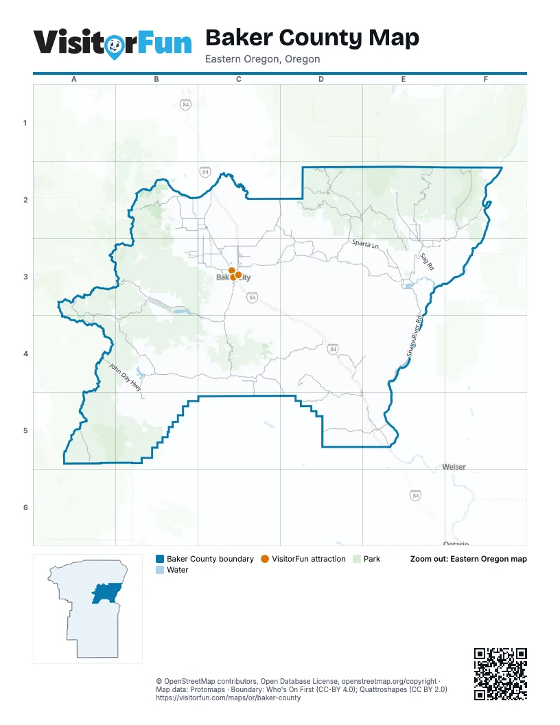
Street index of Baker County
Each street on the sheet and the grid squares it crosses.
- Old Oregon Trail HighwayC2, C3, D3, D4, E4, D5, E5
- Sumpter Stage HighwayB3, C3, B4, C4
- John Day HighwayA4, B4, B5
- Whitney Tipton HighwayA3, A4, B4
- Campbell StreetC3
- Auburn AvenueC3
- Main StreetA3, C3, E3, B5
- Elm StreetC3
- South 1st AvenueB5
- Dewey AvenueC3
- Whitney HighwayC3
- State Highway 7A4
- Baker-UnityC3
- Bridge StreetC3
- Highway 7C3
- Baker-Copperfield HighwayE2, F2, C3, D3, E3, F3
- State Highway 245B4, C4
- La Grande-Baker HighwayC2, C3
- Medical Springs HighwayC2, D2, C3
- Pocahontas RoadC2, C3
- Forest Road 39F2
- Anthony Lakes HighwayB2, C2
- Brownlee-Oxbow HighwayF2, F3
- Oregon Trail BoulevardE5
- National Forest Development Road 73B2
- Granite Hill RoadB3
- State Highway 86E3
- Chandler LaneC3
- Sumpter Valley HighwayB3
- 4th StreetC2, C3
- Broadway StreetC3
- 10th StreetC3
- Cedar StreetC3
- Haines Cemetary LaneB2, C2
- Hughes LaneC3
- Front StreetC2
- Anthony Lake HighwayB2
- Dooley Mountain HighwayB4
- Halfway SpurE3
- Pine Creek HighwayE3
- Huntington HighwayE5
- South Mill StreetB3
- Mill StreetB3
- Sumpter HighwayB3
- South Main StreetE3
- North Cedar StreetC3
- East Washington StreetE5
- East Record StreetE3
- West Washington StreetE5
- Ellis RoadB2
- Eagle Creek RoadD2, E2, E3
- Snake River RoadE3, E4, E5
- Forest Road 66E2, F2
- Collins RoadD2
- Rye Valley LaneD4, D5, E5
- Burnt River Canyon LaneC4, D4
- Sparta LaneD3, E3
- Malheur Line RoadD5, E5
- Big Creek RoadD2
- Greenhorn RoadA3, A4
- Cornucopia HighwayE2
- Clarks Creek RoadC4, D4, D5
- Whitney RoadB4
- Miles Bridge RoadC2, D2, D3
- North Fork Burnt River RoadB4
- Mormon Basin RoadD4, C5, D5
- Forest Road 13A5
- Old Wingville RoadC2, C3
- Plano RoadD4
- Bridgeport LaneC4
- Sisley Creek RoadD4, E4
- Foothill RoadB2
- Middle Bridge LoopD3
- Brown RoadC2, C3
- South Rock Creek LaneB2, C2
- Wingville LaneC3
- Empire Gulch RoadD2, E2
- Keating Grange LaneD3
- Old Trail RoadC3
- West Airport RoadC3
- Keating RoadC3, D3
- Pine Town LaneE3
- Clear Creek RoadE2
- Two Color-Eagle Creek RoadD2
- Fish Lake RoadE2, E3
- Slaughterhouse RoadE2, E3
- Malheur Reservoir RoadC4, C5
- Pioneer LaneC4
- Lone Fir RoadE2, E3
- East Eagle Creek RoadD2, D3
- Pine Creek LaneB3, C3
- Muddy Creek LaneB2
- 2nd StreetC2, C3, E3
- Banta RoadD3
- New Bridge RoadE3
- South Airport LaneC3
- Goodrich Creek LaneB3, C3
- Burnt River RoadB4
- Halfway-Cornucopia HighwayE2
- West Campbell LoopC3
- Sparta RoadE3
- Keating Cutoff RoadD3
- Boulder Flat LaneE2
- Ben-Dier LaneB3, C3
- 1st StreetC2, B3, C3, E3
- Keating Grange RoadD3
- Chico StreetC3
- Neill-Peck LaneC2
- Gulick RoadE3
- Resort StreetA3, C3
- Robinette RoadE3
- Hudson RoadC3
- Chandler Lane Cutoff RoadC3
- Rock Creek Town RoadB2
- Forest Road 16A5
- 17th StreetC3
- Robbinette RoadE3
- North Main StreetE2, E3
- SpartalnE3
- Durkee RoadD4
- Governor LaneE3
- Sawmill Cutoff LaneE3
- Hewitt DriveE3
- West Record StreetE3
- 1st Street WestE5
- Golden Age Mine RoadD5
- Holcomb LaneE3
- Forest Road 454F2
- Forest Road 1305A3
- Neill-Peck RoadC2
- Forest Road 11B3, B4, C4
- Forest Highway 16A5, B5
- National Forest Development Road 11C4
- Water Gulch RoadB4
- National Forest Development Road 7395B3
- Sardine Creek RoadD3
- Ruckles Creek RoadC3, D3
- Fivemile RoadD3
- Forest Road 1090B3, B4
- Homestead RoadF2
- Love Reservoir RoadD3
- Forest Road 7735E2, E3
- Lawrence Creek RoadD3
- Shirttail Creek RoadD4
- Forest Road 1680B5
- Gilkison Mill RoadD2, D3
- South Boundary RoadD2
- Summit Creek RoadE2, E3
- Forest Road 3992E2, F2
- Geiser Creek RoadA3
- Forest Road 7740D2
- National Forest Development Road 150C3, C4
- Forest Road 1055B3
- Forest Road 7035D2
- Howard Meadows RoadA3, A4
- Forest Road 1145B4, C4
- Powder River RoadB3, E3
- Forest Road 1040A4, B4
- Rice RoadB4
- Mother Lode RoadD2, D3
- National Forest Development Road 1125C4
- National Forest Development Road 1120C4
- Forest Road 6550B3
- Cracker Creek RoadB3
- Forest Road 1165B4
- East Eagle RoadD2, E2
- National Forest Development Road 1118C4
- Coffey LaneC2
- Schoolhouse RoadB2, B3, C3
- Ledge Creek RoadD2
- Lower Powder RoadC2, D2, C3, D3
- National Forest Development Road 4135E2
- Forest Road 015D2
- Bulger Flat LaneB2
- Forest Road 6625E2
- Alder Creek RoadC3, D3, C4, D4
- Puzzle Creek RoadD2, E2
- Sawtooth RoadD2
- Sutton Creek RoadC3, C4
- Dempsey Creek RoadD2
- Forest Road 830D2
- Pine Creek RoadC4
- Forest Road 1170B4
- Mc Carty Bridge RoadC2
- Beaver Creek RoadC3, C4
- Packwood RoadD2
- Burn-Balm RoadD2
- National Forest Development Road 1680B5
- Sag RoadE3
- Forest Road 1160B4
- Ebell Creek RoadC3, C4
- West Sutton Creek RoadC3, C4
- Dry Creek RoadC3, C4
- Balm Creek RoadD2
- Manning Creek RoadD4
- National Forest Development Road 1925A4, B4
- National Forest Development Road 100B3, B4, C4
- Haines Dump RoadC2
- Forest Road 350D2
- Huckleberry LoopB3
- Sparta Butte RoadD2, E2, E3
- Forest Road 1940A4, B4
- Hereford Loop RoadB4
- Torchlight Gulch RoadD2
- Wirth RoadD2
- Bidwell RoadC2
- Morgan Creek RoadE4
- Forest Road 800D2
- Old Auburn LaneC3
- Lindley RoadC3
- South Fork Burnt River LaneB5
- John Widman RoadD3
- Little Eagle RoadD2, E2
- Langrell Gulch RoadD2
- National Forest Development Road 270C4
- Cook RoadD2, D3
- Sunnyslope RoadC3
- Ritter Creek RoadE3
- National Forest Development Road 050C4
- Schetky RoadC2, C3
- Denny Creek RoadC4
- Conro RoadC2
- Upper Bennet RoadD2
- Houghton Creek RoadD2
- Hibbard Creek RoadE4
- Forest Road 7741E2, E3
- Murray RoadB5
- Coyote Peak RoadC2
- Buchanan RoadE2, E3
- Forest Road 190A3
- Williams WallC3
- Stices Gulch RoadC4
- Beaver Creek LoopC3
- National Forest Development Road 060C4
- Forest Road 3990F2
- Cemetery RoadB4, B5
- White Swan RoadC3, D3
- Forest Road 3994E2
- Hooker Flat RoadE2
- National Forest Development Road 095C4
- Vandecar RoadD4
- Shaffner Creek RoadC3
- National Forest Development Road 7720B3, C3
- Pole Line LaneC3
- First Creek RoadD3
- Hunt Mountain LaneB3, C3
- West Dry Creek RoadE2
- Hindman RoadD4
- Forest Road 7737E2
- Slough RoadC2, C3
- Sinclair RoadD3
- Virtue Mine RoadC3
- Forest Road 1684B5
- Deems LoopB3
- Old Ranger Station RoadE2, E3
- National Forest Development Road 7302B2
- Forest Road 1035-125A4
- Larch Creek RoadB3
- East Pine RoadE2
- North Rock Creek LaneB2, C2
- Ritter Loop RoadD3
- Sawmill Gulch RoadA3, B3
- Washington Gulch RoadC3
- National Forest Development Road 1110C4
- Old Foothill RoadE3
- National Forest Development Road 1115C4
- Forest Road 19A3
- Forest Road 7739E2
- East Dry Creek RoadE2
- Kitchen Creek RoadC4, D4
- Shanghai RoadE2
- Forest Road 020D2
- 3rd StreetC2, C3, E3
- Carson Grade RoadE2
- Dry Creek Cut Off RoadC3, C4
- Sand Hollow RoadE5
- Balm CutoffD2
- National Forest Development Road 7312B2
- Forest Road 1140C4
- Forest Road 6617E2
- National Forest Development Road 77E3
- Forest Road 200E2
- Forest Road 7025D2
- Elk Spring RoadD2
- Benson Birch RoadE5
- Forest Road 6510B3
- Hudspeth LaneB3, B4
- National Forest Development Road 020C4
- Oxman Ranch LaneD4
- Deer Creek RoadB3
- Burn Creek RoadD2
- Talley-Dobbins LaneB2
- Dry Gulch RoadE3
- National Forest Development Road 1055B3, B4
- Lee LaneC3
- National Forest Development Road 1130C4
- Dempsey CutoffD2
- Gate RoadD4
- Rouse LaneB4
- Sky Ranch LaneC2
Things to do on the Baker County map
Places on the map
- Anthony Lake
- Anthony Lakes Mountain Resort
- Baboon Creek Quarry
- Baker City
- Baker City Golf Club
- Baker Historic District
- Baker Municipal Airport
- Balm Creek Reservoir
- Clear Creek Lake
- Copperfield Park
- Crater Lake
- Crow Reservoir
- Durkee Quarry
- Dutch Flat
- East Lakes Reservoir
- Elms Reservoir
- Farewell Bend State Recreation Area
- Fish Lake
- Goodrich Lake
- Gray Eagle Mine
- Greenhorn
- Haines
- Haines Landfill
- Halfway
- Hole in the Wall Landslide
- Homestead Wilderness Study Area
- Huntington
- Killamacue Lake
- Laird Reservoir
- Lake Bob
- Love's Travel Stop
- Mayflower Meadow
- Mehlhorn Lake
- Monument Rock Wilderness
- Phillips Lake
- Sheep Mountain Wilderness Study Area
- Sumpter
- Union Creek Campground
- Unity
- Unity Reservoir
Next to Baker County
- Ontario
- Weiser
© OpenStreetMap contributors, Open Database License, openstreetmap.org/copyright · Map data: Protomaps · Boundary: Who's On First (CC-BY 4.0); Quattroshapes (CC BY 2.0)















