

Oregon map
Lincoln County map
About 51,212 people live here (Census Bureau, 2024 estimate). The sheet's index lists 300 streets; Oregon Coast Highway, Corvallis Newport Highway and Logsden Road cross the most grid squares. Things to do inside the boundary: Cape Perpetua Scenic Area, Chinook Winds Casino Resort and Hatfield Marine Science Center Visitor Center.
Open the map (PDF, US Letter)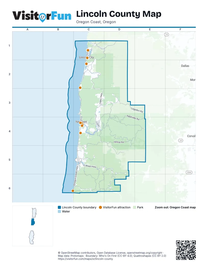
Street index of Lincoln County
Each street on the sheet and the grid squares it crosses.
- Oregon Coast HighwayC1, C2, C3, C4, C5, B6, C6
- Corvallis Newport HighwayC3, D3, C4, D4, E4
- Salmon River HighwayC1, D1
- Northeast Highway 20C4
- Northwest Highway 20C4
- East Olive StreetC4
- West Highway 20C4
- Southwest Naterlin DriveC4
- U-Turn Pull OutC2
- East Highway 20C4
- US 101 U-turn LaneC2
- Siletz HighwayC2, C3, C4
- East Alsea HighwayC5, D5, D6
- Nashville RoadD3, D4, E4
- Yaquina Bay RoadC4
- Crystal Creek LoopD3, D4
- Northeast West Devils Lake RoadC1
- Southeast Bay BoulevardC4
- Southeast Sturdevant RoadC4
- Northeast Alsea HighwayC5
- Northeast Sturdevant RoadC4
- Northeast Arcadia DriveC4
- Southeast Butler Bridge RoadC4
- Southeast East Slope RoadC4
- Northeast 11th StreetC1, C4
- Bay BoulevardC4
- Northwest A StreetC3, C4
- Northeast 14th StreetC1
- Northwest 11th StreetC1, C4
- Southeast 10th StreetC4
- Southeast Moore DriveC4
- Northwest 1st StreetC4
- North Gaither StreetC3
- Northwest Hemlock StreetC5
- South Gaither StreetC3
- Northwest Alsea HighwayC5
- Northwest Highway 229C4
- Northwest Butler Bridge RoadC4
- Alsea HighwayD5
- Logsden RoadC3, D3, E3, E4
- Harlan RoadD4
- 1000 Line RoadC4, D4, D5
- Elk City RoadD3, C4, D4
- United States Forest Service Road 53C5, C6
- United States Forest Service Road 58C5, D5, C6, D6
- North Beaver Creek RoadC4, C5
- East Five Rivers RoadD6
- Yachats River RoadC6
- North Bayview RoadC5
- Hilltop RoadD4
- South Schooner Creek RoadC1, D1, C2
- Harlan-Burnt Woods RoadD4, E4
- South Bay RoadC4
- East Buck Creek RoadC6, D6
- Sams Creek RoadD3
- South Beaver Creek RoadC5
- United States Forest Service Road 55C6
- South Drift Creek RoadC2
- North North Bank RoadC1, D1
- East Canal Creek RoadC5, C6
- Sunnyridge RoadC4
- Moonshine Park RoadD3
- Northeast East Devils Lake RoadC1
- Otter Crest LoopC3
- North Old Scenic Highway 101C1
- North Bear Creek RoadC1, D1
- Yasek LoopC3, C4
- Northeast Old River RoadC3
- North Three Rocks RoadC1
- Feagles Creek RoadD4, D5
- United States Forest Service Road 5304C6
- Fruitvale RoadC4
- East Eckman Creek RoadC5
- South Crestline DriveC5
- Southwest Coast AvenueC1, C2, C3
- Northwest Cross StreetC5
- Northwest Logan RoadC1
- Northwest Oceania DriveC5
- Northeast Avery StreetC3, C4
- Grant Creek RoadD4
- Northwest Oceanview DriveC3, C4, C5
- Northwest Jetty AvenueC1
- Southwest Wakonda Beach RoadC5
- United States Forest Service Road 37D6
- United States Forest Service Road 54C6
- Northeast Yaquina Heights DriveC4
- Southwest Abalone StreetC4
- Southeast 35th StreetC2, C4
- Northwest Keel AvenueC1
- Northwest Nye StreetC4
- South Anderson Creek RoadC2
- Southeast 2nd StreetC1, C4
- Northwest Lighthouse DriveC3
- Northeast Beverly DriveC3
- East Lobster Valley RoadD6
- Northwest Sunset DriveC4
- East Boundary RoadD5
- Northwest Inlet AvenueC1
- Gleneden Beach LoopC2
- Northeast Harney StreetC3, C4
- Southwest Fleet AvenueC1, C2
- Northeast 10th StreetC1, C4
- Ocean View DriveC6
- Northwest Seal Rock StreetC5
- Southwest 9th StreetC1, C4
- Southeast 3rd StreetC1, C4
- Southwest Range DriveC5
- Western LoopC4
- Northwest Bayshore DriveC5
- Northeast 1st StreetC1, C4
- Northwest Spring StreetC4, C5
- Southwest Anchor AvenueC1, C2
- Southwest Elizabeth StreetC4
- Northeast Alder StreetC4, C6
- Southwest 10th StreetC1, C4
- Southeast East Devils Lake RoadC1
- Southeast Marine Science DriveC4
- Northwest Sandpiper DriveC5
- Southeast High School DriveC2
- Northeast 3rd StreetC4
- Southwest 7th StreetC1, C4
- Southwest Galley AvenueC1, C2
- Southwest Ebb AvenueC1, C2
- North East Three Rocks RoadC1
- Southeast Ferry Slip RoadC4
- Northwest 6th StreetC4
- Northeast Mossy LoopC4
- Northeast Eads StreetC4
- Northeast Neotsu DriveC1
- 1st StreetC3, C6
- Neptune AvenueC2
- Northeast 6th StreetC4
- Northeast Holmes RoadC1
- East Logsden RoadC3
- East Collins StreetC2
- Northwest Skyline DriveC4
- Northwest Coast StreetC4
- Northeast 22nd StreetC1
- Northwest 25th StreetC1, C4
- Southwest 12th StreetC1, C4
- Southwest 62nd StreetC2, C4
- Judd RoadC3
- Gwee-Shut RoadC3
- Northwest 15th StreetC1, C4
- Southeast Harborton StreetC4
- Northeast 36th DriveC1
- Northwest Harbor AvenueC1
- Southwest Bay BoulevardC4
- Northeast Oar AvenueC1
- Northeast East Slope RoadC4
- Northwest 10th StreetC4
- Southeast Fir StreetC4
- Southeast 51st StreetC2
- Southwest 2nd StreetC4
- Southwest Norwood DriveC5
- 3rd StreetC3
- West Olive StreetC4
- Southeast 4th StreetC4
- Southwest Hurbert StreetC4
- Southwest 51st StreetC2
- Southwest Fall StreetC4
- Southeast 48th PlaceC2
- Northwest 44th StreetC1, C3
- Northeast 36th StreetC3
- Southeast Douglas StreetC3, C4
- Northeast 123rd StreetC3
- North Main StreetC4
- Northwest 22nd StreetC1, C4
- Northeast Broadway StreetC5
- Southwest Bay StreetC4
- Northeast Crestline DriveC5
- Northwest 8th StreetC4
- Southwest 13th StreetC1, C4
- United States Forest Service Road 3462C6
- Southwest Abbey StreetC4
- Southeast Ash StreetC4
- Southwest 50th StreetC2
- Northeast 54th StreetC3
- Southeast Elder StreetC4
- Northwest 30th StreetC1
- Northwest 28th StreetC1
- Northwest 20th StreetC1, C4
- East Graham StreetC4
- Southwest Inlet AvenueC2
- Northwest 14th StreetC1, C4
- Northwest 17th StreetC1, C4
- Southeast 84th StreetC4
- Southwest 69th StreetC2
- Southwest Starr StreetC5
- Northwest 21st StreetC1, C4
- Southeast Fogarty StreetC4
- Northeast Burgess RoadC4
- Northeast Lucky Gap StreetC3
- Northwest Edenview WayC4
- Southwest 63rd StreetC2
- Wesler StreetC2
- Southwest 35th StreetC2, C4
- Northeast Skyline DriveC4
- Southwest Cedar StreetC5
- Northeast 73rd StreetC1, C3
- Laurel StreetC2
- Southeast 40th StreetC4
- Southwest Angle StreetC4
- Stevens StreetC2
- Southeast 6th StreetC4
- Northwest 40th StreetC1
- Southeast Beech StreetC4
- Northwest Cedar StreetC5
- Southwest Bayley StreetC4
- Southwest 14th StreetC1
- Southwest Jetty AvenueC2
- Southwest Hatfield DriveC4
- Northeast Windmill DriveC3
- Southeast Gaither WayC4
- Southwest 11th DriveC1
- Marine DriveC6
- Southeast Pacific WayC4
- Southwest Government StreetC4
- Southwest Canyon WayC4
- C AvenueC3
- Northwest Dundon RoadC4
- Southeast 7th StreetC4
- Southwest 24th DriveC1
- Northwest Westward StreetC5
- Northeast Oar PlaceC1
- Southwest Harbor DriveC4
- Northwest Lincoln WayC4
- Southeast College WayC4
- Southwest Nye StreetC4
- Lori LaneC6
- Southwest 32nd StreetC2
- North Jetty AvenueC1
- South Main StreetC4
- Northeast 52nd StreetC3
- Northeast Palmer StreetC3
- Southeast Benton StreetC4
- Rocky Creek BridgeC3
- Northwest 2nd DriveC1
- Lobster Valley RoadD6
- West Graham StreetC4
- Drift Creek RoadC2
- South Ferry Crossing Slip RoadC4
- Horse Creek RoadC6
- Cougar Ridge RoadD6
- United States Forest Service Road 17D1, C2, D2
- BLM 10 (aka BLM 13-7-10)D5, E5
- United States Forest Service Road 51C5
- United States Forest Service Road 5360C5, C6
- United States Forest Service Road 52D5
- United States Forest Service Road 1726C1, D1
- South Immonen RoadC2
- Barber Ridge RoadD4
- Forest Road 3412D6
- United States Forest Service Road 3446C5, D5
- United States Forest Service Road 3105D4, D5
- United States Forest Service Road 3109D4, D5
- United States Forest Service Road 3210D6
- East Fall Creek RoadD5
- United States Forest Service Road 3119D4, D5
- Gopher Creek RoadD4, D5
- United States Forest Service Road 1790C2
- United States Forest Service Road 1046C6
- Forest Road 30E4, E5
- Mill Creek RoadD3, C4
- Norton RoadD3
- Shot Pouch RoadE4
- Clem RoadE4
- Marys Peak RoadD4, E4
- Lindsey Ridge RoadD1
- Forest Road 3415D5, D6
- United States Forest Service Road 50C4, C5
- Salmon Creek RoadD4
- Deer Creek RoadD4
- North Forest RoadC1, D1
- United States Forest Service Road 3015D4, D5, E5
- United States Forest Service Road 3430D5, D6
- Pioneer Mountain LoopC3, D3
- United States Forest Service Road 1045C5, C6
- Hidden Valley RoadC4
- North May RoadC5
- North Slick Rock Creek RoadD1
- Olalla RoadC3, C4
- East Tidewater RoadD5
- United States Forest Service Road 5087C5
- Salishan DriveC2
- Twin Bridges DriveD3
- Northeast Big Creek RoadC4
- Hayes Creek RoadD3, D4
- East Risley Creek RoadC5
- Little Switzerland RoadC5, D5
- Steer Creek RoadD3, E3
- United States Forest Service Road 3020E4
- Updike RoadD4
- Ojalla RoadC3
- Criteser LoopC4
- WSG Access RoadC1
- Southeast 98th StreetC4
- United States Forest Service Road 1782D1
- Goat Ridge RoadE4
- United States Forest Service Road 5421C6
Things to do on the Lincoln County map
Places on the map
- Agate Beach
- Agnes Creek Open Space
- Beverly Beach
- Beverly Beach State Park
- Big Creek Reservoir Number 2
- Big Stump Beach
- Brian Booth State Park
- Camp Westwind (private)
- Cape Perpetua Marine Garden
- Cape Perpetua North Marine Protected Area
- Cascade Head Marine Reserve
- Cascade Head South Marine Protected Area
- Cedar Creek Quarry
- Chinook Winds Golf Resort
- Cutler City
- Delake
- Depoe Bay
- Devil's Lake
- Drift Creek Wilderness
- Eckman Lake
- Fischer Pit
- H.B. Van Duzer Forest State Scenic Corridor
- Hatfield Marine Science Center
- King Slough
- Lincoln Beach
- Lincoln City
- Moolack Beach
- Nelscott
- Newport
- Newport Municipal Airport
- Nye Beach
- Ocean Shore State Recreation Area
- Oceanlake
- Olalla Reservoir
- Otter Rock Marine Reserve
- Roads End
- Rose Lodge
- Salishan Golf Links
- Seawall flat
- Siletz
Next to Lincoln County
- Corvallis map
- Dallas map
- Philomath
© OpenStreetMap contributors, Open Database License, openstreetmap.org/copyright · Map data: Protomaps · Boundary: Who's On First (CC-BY 4.0); Quattroshapes (CC BY 2.0)















