

Oregon map
Morrow County map
About 12,360 people live here (Census Bureau, 2024 estimate). The sheet's index lists 300 streets; Columbia River Highway, Heppner-Spray Highway and Ione-Gooseberry Road cross the most grid squares. Things to do inside the boundary: Boardman and SAGE Center.
Open the map (PDF, US Letter)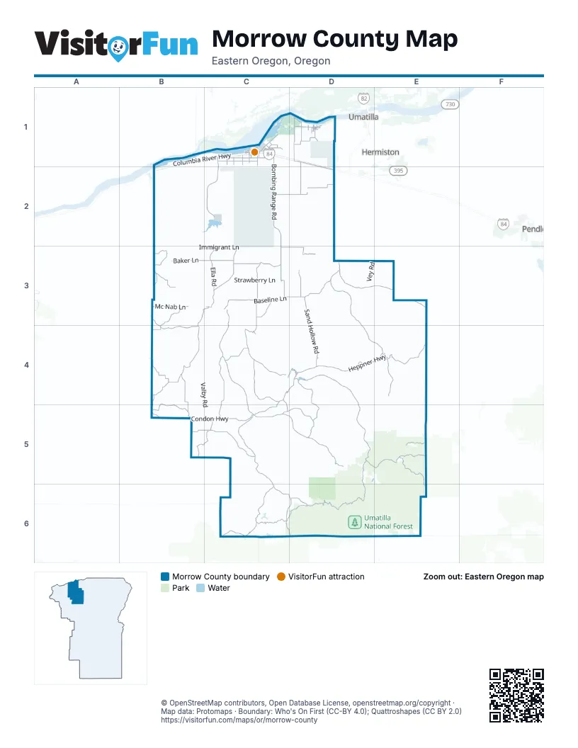
Street index of Morrow County
Each street on the sheet and the grid squares it crosses.
- Columbia River HighwayB1, C1, D1, B2
- Old Oregon Trail HighwayC1, D1, D2
- Cutsforth-Baseline RoadC3, C4
- Mc Nab LaneB3
- South Main AvenueD1
- Main StreetC1, D4
- West Main StreetC3, C4
- East Main StreetC3, C4
- West Linden WayD4
- E StreetC4
- Lexington-Echo HighwayC3
- Heppner-Spray HighwayC4, D4, C5, C6
- Heppner HighwayD4, E4
- Willow Creek RoadD4, D5
- Bombing Range RoadC1, C2, C3
- Rhea Creek RoadC3, C4, C5
- Little Butter Creek RoadD3, D4, E4
- Condon HighwayB4, B5, C5
- Big Butter Creek LaneD3, E3
- Paterson Ferry RoadD1, D2
- Baseline LaneC3, D3
- Forest Road 53D5, E5
- Ella RoadC3
- Ione-Boardman RoadC3
- Little Juniper LaneC3
- Wasco-Heppner HighwayB5, C5
- Wilson Lane SoutheastC1
- National Forest Development Road 53D5
- Northeast Columbia AvenueC1
- Jordan Grade RoadC3
- Laurel LaneC1
- South Main StreetC1, D4
- North Main StreetC1, D4
- State Highway 206C5
- North Court StreetD4
- East May StreetD4
- Ruggs-Jordan RoadC3
- Forest Road 21D5, C6, D6
- Ione-Gooseberry RoadB3, C3, B4, B5
- Upper Rhea Creek RoadC5, D5
- Clarks Canyon RoadC4
- Sand Hollow RoadD3, D4
- Tower RoadC1, C2
- Liberty School RoadC4, C5
- Little Buttercreek RoadD3
- Homestead LaneC2, D2
- Baker LaneB3, C3
- Balm Fork RoadD4, D5
- Halversen LaneB3, B4
- Hale Ridge LaneB5, C5
- Jones Prairie RoadE5, E6
- Sunflower Flat RoadC6, D6
- Fuller Canyon LaneC4, D4
- Smith RoadB3, B4
- Alpine LaneC3, D3
- Dry Fork RoadB4
- Hardman Ridge RoadC5
- Juniper Canyon RoadC3
- Buttermilk Canyon RoadB5, C5
- Sanford Canyon RoadC5, D5
- Myers LaneD3
- Ridge RoadB4
- National Forest Development Road 21C6
- Pole Line RoadD1, D2
- Social Ridge LaneC4
- Palamateer RoadB3
- Depot LaneD1
- North Sand Hollow RoadD3
- Forest Road 5314E5
- Kunze LaneC1
- Columbia AvenueC1
- Tupper LaneD6
- Cecil LaneB3
- Lunceford Canyon RoadD5
- Kilkenny RoadC3
- Columbia LaneD1
- West 8th RoadD1
- Lewis and Clark DriveC1
- Wilson LaneC1
- Lexington Grange RoadC3
- Fairview LaneB3
- Fourmile RoadB3
- Forest Road 22C6, D6
- Dalzell RoadB4, B5
- Basey Canyon RoadC4, C5
- Redding RoadC5
- Division RoadD1
- Miller RoadC1
- Paul Smith Road SouthwestC1
- Marine Drive NortheastC1
- Riverview LaneD1
- Gar Swanson DriveC1
- Peters RoadC1
- Toms Camp RoadC1
- Kunze Lane SouthwestC1
- 2nd Street WestD1
- Marine Drive NorthwestC1
- Front Street NortheastC1
- Southeast Idaho AvenueD1
- East Kunze RoadC1
- Wilson Road SouthwestC1
- West 4th RoadD1
- Southeast California AvenueD1
- Boardman Avenue NorthwestC1
- Division StreetD1
- Riverside AvenueD4
- Ulman BoulevardC1
- Oscar Peterson DriveC1
- Northwest Columbia AvenueC1
- South 1st StreetD1
- Southeast Utah AvenueD1
- Olson RoadC1
- Kunze Lane SoutheastC1
- Oregon Trail BoulevardC1
- Internet ParkwayC1
- Anderson RoadC1
- North 1st StreetD1
- Gale StreetD4
- Morgan StreetD4
- Northeast 3rd StreetD1
- Southeast 14th StreetD1
- Northeast 10th StreetD1
- Southwest Wyoming AvenueD1
- Southeast Wyoming AvenueD1
- Southeast 7th StreetD1
- West StreetC4, D4
- County Road 584C1
- Church StreetD4
- South Spring StreetC3
- Spruce LaneD4
- North H StreetC3
- Front Street SoutheastC1
- National Forest Development Road 2219D6
- North Green StreetC3
- West May StreetD4
- Hinton DriveD4
- Buttermilk RoadB5
- Immigrant LaneB3, C3
- National Forest Development Road 2104D5, D6, E6
- Spring Hollow RoadC5
- Valby RoadB4, C4, C5
- Toll Rock RoadC5, D5
- Spur LoopD3, D4
- National Forest Development Road 2105D6, E6
- Wyland Grade RoadC5, C6
- Blackhorse Canyon LaneC4, D4
- Stock Drive RoadC4
- Strawberry LaneC3
- National Forest Development Road 5326D5, E5
- Nichols LaneC3, C4
- Wilson Creek RoadD5
- Road Canyon RoadD5
- Dave Reitmann RoadC3
- Nolan RoadC4
- Bell Canyon LoopC4, D4
- Brenner Canyon RoadB4, C4
- Boardman Canal LaneC1
- Morgan RoadB3
- Mc Elligott RoadB4
- Dee Cox RoadD4
- National Forest Development Road 2106E6
- Barlow Canyon LaneB4, C4
- Kincaid LaneB4
- Rietmann LaneB3, C3
- Carlson LaneB4, C4
- Shobe Canyon RoadD4, D5
- Pettys Canyon LaneC3
- Piper Canyon RoadC3, C4
- Barclay LaneD3
- Campbell RoadD3
- Vey RoadD3, E3
- Dale Brown RoadC4, C5
- Morter LaneB4, C4
- Melville LaneD3
- Board Creek RoadD5, D6
- Cutsforth RoadC3, D3
- Lindsay West RoadC3
- Tews LaneB4
- National Forest Development Road 5321E5
- Bunker Hill LaneC4
- Lindsay Feedlot LaneC2, D2
- Grieb LaneC3, D3
- Ely Canyon LaneB3
- Deadman Hill LoopC5, C6
- Bergstrom LaneC4
- Meadow Brook RoadC4
- County Road 4602C6
- Frontage LaneC1, D1
- National Forest Development Road 2128C6
- Crum RoadC3
- Lloyd RoadC3
- Taggares LaneB2, C2
- Lindstrom LaneB3, C3
- Logan LaneC4
- Canal LaneC1
- Lindsay RoadC3
- Holtz LaneB4
- Umatilla Auto Tour RouteC1, D1
- Benge RoadC4
- Zinter RoadB3
- Boardman Flight StripC1, B2, C2
- Johnson Grade RoadB3, C3
- Huges-Hirl RoadE4
- Wells Spring RoadC3
- Beach LaneC3, D3
- Kemp LaneC3, D3
- Cemetery Hill RoadC4
- Elmer Griffith RoadB3
- National Forest Development Road 3310E5
- Lundell RoadB4
- Porcupine LaneC5
- County Line RoadD2
- Bert Peck LaneC4
- Turner LaneC3
- Jason RoadB3, B4
- Sumner RoadB5
- Gabbett RoadB4
- Doherty RoadD3
- National Forest Development Road 2103D5, E5, E6
- Gun Club LaneD1, D2
- Gus RoadB4
- Olden LaneB4, C4
- Sim-Tag LaneB2
- Blackhorse Canyon RoadC4
- Wheatland RoadC3
- National Forest Development Road 050D5
- Kenny RoadD4
- Washington LaneD1
- Stock Drive LaneC4
- Swanson RoadB4
- Lovegren RoadC3
- National Forest Development Road 140E5
- Rippee RoadC1
- National Forest Development Road 033E5
- Root LaneC1
- Three Mile Canyon RoadB2
- Dolven RoadC3, D3
- National Forest Development Road 030D5
- Barak Martin RoadC3
- Olson Road SoutheastC1
- National Forest Development Road 3315E5
- Desert RoadD2
- Wagon Wheel LoopD1
- Holtz RoadB3, B4
- Proudfoot RoadC3
- Young LaneC4
- Penland LaneD5
- Lower Sand Hollow RoadD3
- 3rd Street WestD1
- Fuller Canyon LoopC4
- Northeast Boardman AvenueC1
- Howton LaneB4
- National Forest Development Road 060E5
- Utility LaneC1
- Nevada AvenueD1
- East Oregon LaneD1
- Northeast Washington AvenueD1
- Willow Fork Drive SouthwestC1
- Mader Rust LaneD3
- National Forest Development Road 3308E5
- Homestead RoadD2
- Southeast Airport RoadC1
- Airport RoadC4
- Gar Swanson RoadC1
- Park LaneD5
- Northeast Main AvenueD1
- Idaho LaneD1
- 4th Street WestD1
- Kinkade RoadC1
- Sunset LaneD1
- West 7th RoadD1
- Emert RoadC3
- Warren LaneB4
- Estregaard RoadC1
- Meadow LoopC1
- Marshall Loop NortheastC1
- Water StreetD4, C5
- National Forest Development Road 3309E5
- C StreetC4
- Pleasant View RoadD1
- Tatone StreetC1
- Northeast Oregon AvenueD1
- Skoubo LaneC1
- Three Mile CanyonB2
- Southeast Knapp AvenueD1
- Southeast Thomas AvenueD1
- Froberg RoadD1
- F StreetC4
- Rand RoadD1
- Northwest Oregon AvenueD1
- Parkside DriveC1
- National Forest Development Road 330E5
- Eightmile Canyon RoadB3
- Penland Lake RoadD5
- Cemetery RoadC3
- Willow View DriveD4
- Southeast 10th StreetD1
- Delbert DriveC3
- City CircleC1
- Perkins RoadD3
Things to do on the Morrow County map
Places on the map
- Anson Wright Memorial Park
- Arbuckle Mountain
- Bald Mountain
- Barlow Butte
- Big Rock Flat Airstrip
- Black Mountain
- Boardman
- Boardman Airport
- Boardman Bombing Range
- Boardman Marina
- Boardman Marina Park
- Boardman Post Office
- Boardman Rest Area Eastbound
- Boardman Rest Area Westbound
- Boardman RV Park
- Burton Hill
- Camas Butte
- Carpenter Butte
- Carty Reservoir
- Coalmine Hill
- Coyote Springs Wildlife Area
- Heppner
- Ione
- Irrigon
- Irrigon Wildlife Area
- Lake Penlund
- Lake Umatilla
- Lexington
- Love's Travel Stop
- Marina Park
- Martin Prairie
- Meenderinck Dairy
- Miller Prairie
- Raymond F. Rees Training Center
- Riverside High School
- Umatilla Army Depot (Lagoons) Superfund Site
- Umatilla National Forest
- Umatilla National Wildlife Refuge
- Willow Creek Country Club
- Willow Creek Reservoir
Next to Morrow County
- Hermiston map
- Pendleton map
- Umatilla
© OpenStreetMap contributors, Open Database License, openstreetmap.org/copyright · Map data: Protomaps · Boundary: Who's On First (CC-BY 4.0); Quattroshapes (CC BY 2.0)















