

Oregon map
Union County map
About 26,058 people live here (Census Bureau, 2024 estimate). The sheet's index lists 300 streets; National Forest Development Road 020, Old Oregon Trail Highway and 2nd Street cross the most grid squares. Things to do inside the boundary: Eagle Cap Excursion Train and Union County Museum.
Open the map (PDF, US Letter)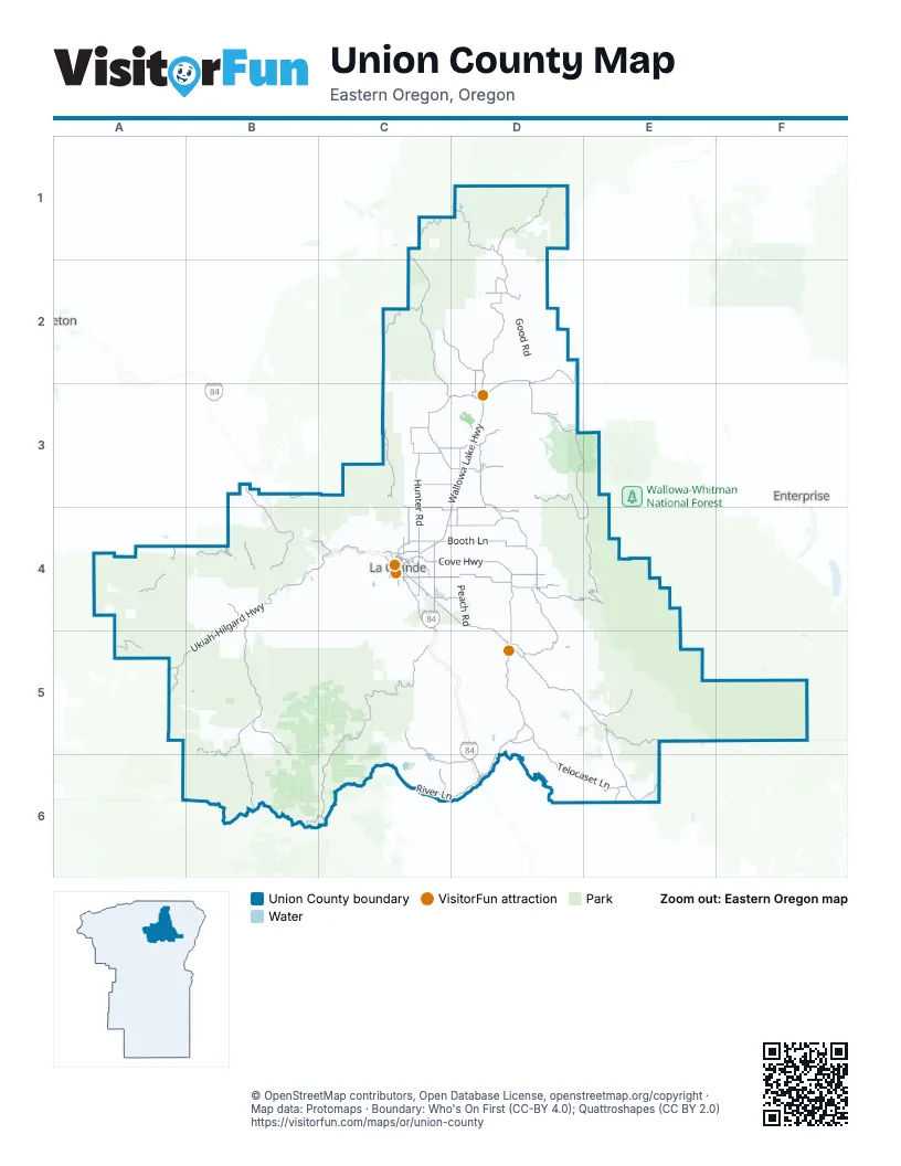
Maps inside Union County
1 map inside, from the street map of Union County down.
Street index of Union County
Each street on the sheet and the grid squares it crosses.
- Old Oregon Trail HighwayB3, B4, C4, C5, D5, D6
- Wallowa Lake HighwayD2, D3, C4, D4
- La Grande-Baker HighwayC4, D4, D5, D6
- Weston-Elgin HighwayC1, C2, C3, D3
- 2nd StreetC3, D3, C4, D4, D5, D6
- Island AvenueC4
- Adams AvenueC4
- South Main StreetD5
- Division StreetD3
- North Main StreetD5
- South 8th AvenueD3
- North McAlister RoadC4
- Ruckman AvenueD3
- East H AvenueC4
- State Highway 82D3
- Albany StreetD3
- West 1st StreetC4
- North 8th AvenueD3
- Ukiah-Hilgard HighwayB4, C4, A5, B5
- Medical Springs HighwayD5, E5, E6
- Grande Ronde River RoadB5, B6
- Cove HighwayC4, D4
- Gekeler LaneC4, D4
- River LaneC6, D6
- National Forest Development Road 51B5, B6
- Summerville RoadC3, D3
- Pierce RoadC4, C5
- State Highway 237D4
- National Forest Development Road 73B6, C6
- Courtney LaneC3, D3
- McAlister RoadC4
- Ellis RoadC6
- Union Cove HighwayD4, D5
- Five Point Creek RoadB4, C4
- Buchanan LaneC4
- Grande Ronde RoadB4, B5
- Striker LaneD3
- 4th StreetC3, C4, D6
- North 2nd StreetC4, D5
- Cove AvenueC4
- X AvenueC4
- Main StreetC3, D3, D4
- North Cove StreetD5
- N AvenueC4
- Jackson AvenueC4
- South McAlister RoadC4
- North Willow StreetC4
- C AvenueC4
- North Depot StreetC4
- Jasper StreetD4
- Main AvenueC4
- East Bryan StreetD5
- North Pine StreetC4
- East Arch StreetD5
- Monroe AvenueC4
- East Beakman StreetD5
- East 1st StreetC4
- Willow StreetC4
- National Forest Development Road 43C5, C6
- National Forest Development Road 62D3, E3, D4, E4
- National Forest Development Road 21A4, B4
- Moss Springs RoadD4, E4
- Telocaset LaneD5, D6, E6
- Skyline RoadC1, C2, C3
- Hunter RoadC3, C4
- High Valley RoadD4, D5
- Palmer Junction RoadD2, D3
- Booth LaneC4, D4
- Forest Road 62D1
- Mount Emily RoadB3, C3
- Eagle Creek RoadE5
- National Forest Development Road 5160A5, B5, B6
- Wolf Creek LaneC5, C6, D6
- Grays Corner RoadD3, D4
- Old Emigrant Hill Scenic Frontage RoadB3, B4
- Lower Cove RoadD4
- Gordon Creek RoadC2, D2
- Forest Road 63D1
- Mount Harris LoopD3, D4
- Foothill RoadC4
- Hindman RoadD2, D3
- Market LaneC4, D4
- Standley LaneC3, B4, C4, D4
- Lookingglass RoadD1, D2
- Mount Glen RoadC4
- Big Creek RoadE6
- French Corral RoadA5
- Woodell LaneC3, D3
- Moses Creek LaneD2
- Alicel LaneD3, D4
- Bowman LoopD2
- Rinehart LaneD3
- Mill Creek LaneD4
- Hamilton Creek Frontage RoadC4
- Catherine Creek LaneE5
- McIntyre RoadB4
- North Fork Catherine Creek RoadE5
- Airport LaneC4, D4
- Government Gulch RoadD5
- Haefer LaneD4
- Middle RoadD2, D3
- Fruitdale LaneC4
- Brooks RoadD3
- McKenzie LaneC3
- Alder StreetD3, C4, D4
- Dry Creek LaneC3
- Leffel RoadC4
- May LaneC4
- Blackhawk Trail LaneC4
- Case RoadD4
- Jefferson AvenueC4
- Washington AvenueC4
- 6th StreetD3, C4, D6
- North Spruce StreetC4
- Y AvenueC4
- Phys Point RoadD4
- Walnut StreetC4
- Hartford LaneD3
- South 12th StreetC4
- Lantz LaneD4
- Walton RoadC4
- M AvenueC4
- North Powder-Ladd Canyon RoadD6
- 21st StreetC4
- North Fir StreetC4
- Oregon Trail RoadD6
- E StreetD6
- East Q AvenueC4
- 26th StreetC4
- 12th StreetC4
- Mulholland DriveC4
- South 20th StreetD3, C4
- 20th StreetC4
- East L AvenueC4
- North Cherry StreetC4
- North 10th AvenueD3
- Riddle RoadC4
- Sunset DriveC4
- Moss Springs Campground RoadE4
- Depot StreetD3, C4
- 25th StreetC4
- Kofford RoadD5
- North Albany StreetC4
- Fir StreetC4
- Progress LoopC4
- Greenwood StreetC4
- Hill StreetD4
- North Portland StreetC4
- French StreetD4
- Cherry StreetC4
- Birch Creek RoadA4
- 27th StreetC4
- Mill Creek RoadD4
- Lewis-Behrens Corner RoadC3
- Forest Road 230A5
- National Forest Development Road 4305B5, C5
- Glass Hill RoadC4, C5
- Forest Road 6413D1
- Hess Cabin RoadD5, E5
- National Forest Development Road 220A4, B5, C5
- Yarrington RoadD2
- National Forest Development Road 5182B6
- National Forest Development Road 100D2, A4, B4, B6
- Peach RoadD4
- Whiskey Creek RoadC4, C5
- Forest Road 7746E5, E6
- Frazier Mountain RoadD5, E5, E6
- Sandridge RoadC3, C4
- National Forest Development Road 4316C5
- Indian Creek RoadD3
- Forest Road 900E5
- National Forest Development Road 2105A5, B5
- National Forest Development Road 030D1, C2, B6
- National Forest Development Road 075B6
- Jimmy Creek RoadD5, D6
- National Forest Development Road 170A4, B6
- Good RoadD2
- Pumpkin Ridge RoadC3, D3
- National Forest Development Road 4330C5, C6
- Morgan Lake RoadC4
- National Forest Development Road 5185B6
- Godley RoadD4, D5
- National Forest Development Road 4350C5, C6
- National Forest Development Road 020D1, C2, B4, C4, B5, C5, B6
- Clark Creek RoadD3
- Shaw Mountain RoadC5
- 202 Mount Emily RoadC3, C4
- National Forest Development Road 400B3, B4
- National Forest Development Road 390B4
- Merritt LaneD2
- Lookout Mountain RoadD1, D2
- National Forest Development Road 4315C5
- National Forest Development Road 3738C2
- Keen-Cabin Creek RoadD2
- National Forest Development Road 450B4
- National Forest Development Road 102A4, A5
- Robbs Hill RoadC4
- Fox Hill RoadC4
- Ladd Canyon-North Powder RoadD5
- National Forest Development Road 5155B5
- National Forest Development Road 340B5
- National Forest Development Road 065B5, B6
- Forest Road 125E5
- Mud Spring RoadC6
- National Forest Development Road 2444B5
- 201 MainlineC3, C4
- Buck Creek RoadE5
- Forest Road 6231D1
- National Forest Development Road 2115A4
- National Forest Development Road 325B6
- National Forest Development Road 5130B5
- National Forest Development Road 125A4
- Roulet LoopD3
- Shaw Creek RoadD3
- Forest Road 3120C3, C4
- Klinghammer-Mc Nab RoadD3, D4
- Little Catherine Meadows RoadE5
- National Forest Development Road 7312C6
- Halley RoadC4
- Sand Pass RoadE5
- National Forest Development Road 2442B5
- Ruckle RoadC3
- Ruckman RoadD4
- National Forest Development Road 6205D3, D4
- Baseline LaneB4
- National Forest Development Road 485B4
- National Forest Development Road 080C2, C5
- Conley RoadD4
- Hardy RoadD2
- National Forest Development Road 2120A4, B5
- Coughanour LaneC6, D6
- Henderson RoadD2, D3
- Webster RoadC3, C4
- Cone DriveD2
- National Forest Development Road 700B4
- Parsons LaneD2, D3
- Reeves Mountain RoadD5, E5
- Hull LaneC3, D3
- Forest Road 64D1
- Forest Road 32C2, C3
- National Forest Development Road 060C2, C5
- Mill Canyon RoadC4
- Owsley Canyon RoadC4
- Forest Road 950E5
- Myers RoadC3
- National Forest Development Road 190C5
- National Forest Development Road 210B5
- Thompson RoadD2
- Middle Fork Catherine Creek RoadE5
- National Forest Development Road 045D1
- Woodruff LaneD4
- Imbler RoadD3
- Craig LoopC3
- National Forest Development Road 035D1, A4
- Hug RoadD3
- National Forest Development Road 110D2, B6
- National Forest Development Road 5175B6
- National Forest Development Road 2155B4
- National Forest Development Road 090C2, D2
- Tucker Flat RoadC6
- Miller LaneD5, C6
- Wilkinson LaneD4
- National Forest Development Road 605B4
- Curtis RoadD4, D5
- Ramo Flat RoadD5
- Valley View RoadD2, D3
- Darr RoadD2
- Fly Creek RoadB5
- South Buck RoadE5
- Private RoadD2
- National Forest Development Road 370A5, B5
- Kingsbury LaneD2
- National Forest Development Road 250B5
- Hot Lake LaneC4, D4
- Follet RoadD2, D3
- Bond LaneC4
- National Forest Development Road 050D1, C2, B6
- Hawkins RoadD4
- National Forest Development Road 175B6
- Haggerty LaneD4
- Starr LaneC4
- National Forest Development Road 5125B5, C5
- Hayes RoadD3, D4
- Forest Service Road 1843B4
- Behrens LaneC3
- National Forest Development Road 5184B6
- Wickens LaneD2
- National Forest Development Road 3733C2
- Lookingglass Hatchery RoadD2
- Rock Creek Frontage RoadC4
- Monroe LaneC3
- McDonald LaneC4
- Wright RoadC4, D4
- Carter RoadD4
- National Forest Development Road 270C5
- Chumos RoadD3
- Dark Canyon RoadB4
- Cedar StreetD3, C4
- 3rd StreetC3, D3, C4, D6
- National Forest Development Road 425B4
Things to do on the Union County map
Places on the map
- Arnoldus Loop Reservoir
- Benson Glacier
- Bill Howell Reservoir
- Buffalo Peak Golf Course
- Catherine Creek Meadow
- Catherine Creek State Park
- Cove
- Eagle Cap Wilderness
- Eagle Lake
- Eastern Oregon Livestock Show
- Echo Lake
- Elgin
- Elgin Mill Wastewater Lagoon
- Elmers Reservoir 1
- Elmers Reservoir 2
- Elmers Reservoir 3
- Fisk Reservoir
- Fleets Loop Reservoir
- Glacier Lake
- Grande Hot Springs RV Resort
- Grande Ronde Hospital
- Hilgard Junction State Park
- Imbler
- Island City
- Jubilee Lake
- La Grande
- La Grande Municipal Airport
- Ladd Marsh
- Ladd Marsh Wildlife Area
- Morgan Lake
- Mt. Emily Recreation Area (MERA)
- North Powder
- Pilcher Creek Reservoir
- Ruckman Reservoir
- Summerville
- Thief Valley Reservoir
- Union
- Vey Sheep Ranch Airstrip
- West Eagle Meadow
- Wolf Creek Reservoir
Next to Union County
- Enterprise
© OpenStreetMap contributors, Open Database License, openstreetmap.org/copyright · Map data: Protomaps · Boundary: Who's On First (CC-BY 4.0); Quattroshapes (CC BY 2.0)















