

Pennsylvania map
White Township map
About 14,988 people live here (Census Bureau, 2024 estimate). The sheet's index lists 300 streets; Route 286 East, Fulton Run Road and Martin Road cross the most grid squares. Things to do inside the boundary: Indiana Mall.
Open the map (PDF, US Letter)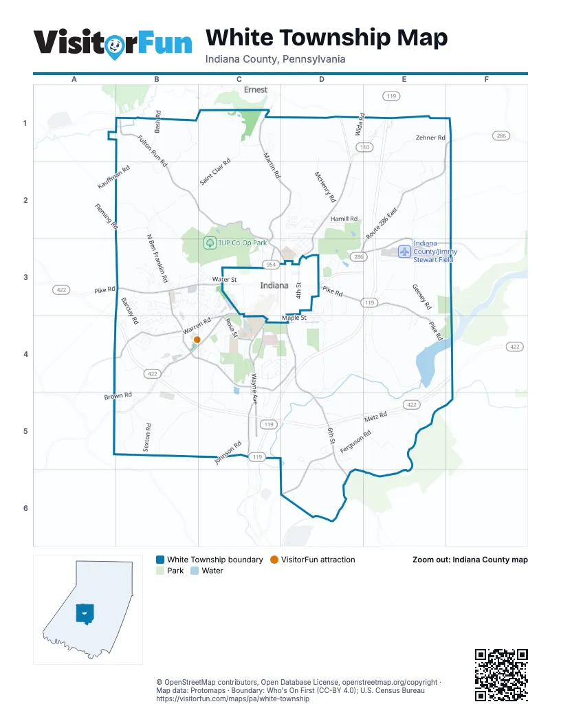
Street index of White Township
Each street on the sheet and the grid squares it crosses.
- Buffalo-Pittsburgh HighwayC5
- Wayne AvenueC4, C5
- Route 286 EastE1, F1, E2, D3, E3
- Old Route 119 Highway NorthD2, D3
- Oakland AvenueC3, B4, C4
- West Pike RoadB3, C3
- Philadelphia StreetB3, C3
- North 4th StreetD3
- Fulton Run RoadB1, B2, C2, C3
- South 6th StreetD4, D5, D6
- Indian Springs RoadB4, C4, D4
- Old Route 119 Highway SouthC5
- Ben Franklin Road SouthB3, B4
- North 9th StreetC3
- Old US 119 Highway SouthC5
- Martin RoadC1, C2, D2, C3
- East Pike RoadD3, E3, E4
- Warren RoadB4, C4
- Airport RoadE2, D3, E3, F3
- Lucerne RoadD5, D6
- Rose StreetC4
- Carter AvenueC4, D4
- Hospital RoadC4
- North 6th StreetC3, D3
- Rustic Lodge RoadC4, B5, C5
- College Lodge RoadB2, B3, C3
- Metz RoadE4, F4, D5, E5
- North Ben Franklin RoadB2, B3
- Ramsey Run RoadE3, E4
- Miller AvenueD2
- Saint Clair RoadC1, B2, C2
- Zehner RoadE1, F1, E2
- Moretti RoadB1, B2
- Geesey RoadE3, E4
- Hamill RoadD2, E2, D3, E3
- Kauffman RoadB2
- Lutz School RoadE1, E2
- Hood School RoadE2, F2, E3
- Twolick DriveD3, D4
- Sexton RoadB5
- Waterworks RoadD4, E4
- Ferguson RoadD5, E5
- Fenton RoadB4
- University DriveC4
- McHenry RoadD1, D2
- Grandview AvenueD3, D4
- Hilltop RoadB5
- Barclay RoadB3, B4
- Jack DriveE3
- Stormer RoadE3
- Wida RoadD1
- Shady DriveB4
- Shelly DriveB3
- Lower Twolick DriveD4, D5
- Simpson RoadC5
- Forest Ridge RoadC3
- Johnson RoadC5
- Privateroad 5000E5
- Valley RoadC4, D4
- Plaza RoadB4
- Lenz RoadB4
- North 5th StreetD3
- Grove LaneC3
- Fyock RoadE2
- Fleming RoadB2
- Ann CircleD5, D6
- Bash RoadB1
- Mansfield AvenueB3, C3
- Clairvaux DriveD3
- South 3rd StreetD3, D4
- Kolter DriveC4
- Mill Run DriveB3, C3
- Maple StreetD4
- Water StreetC3
- Brown RoadA5, B5
- South 13th StreetC3, C4
- Stonebraker RoadE1, E2
- Crystal DriveB3
- Coates LaneC4, D4
- Medlar DriveC3
- Ferrier Run RoadE5
- White Farm RoadD2, C3, D3
- Shaffer DriveD3
- Huckleberry RoadD5
- Heritage Run RoadC3
- Greenview DriveD2, D3
- Timber Springs EstatesC4
- Edgewood AvenueC3
- Lowman RoadE4
- Muller RoadD1
- Melloney LaneB3
- Elkin AvenueD2
- Sterling Hills DriveB3
- Ernest Haul RoadC1
- Hospital DriveC4, D4
- Saddlebrook DriveB3, B4
- Saltsburg AvenueC4
- Hammersmith DriveB3
- Pratt DriveC4
- Sandro StreetD5
- Longs Trailer CourtE2
- Nicola LaneB3, B4
- Sunset DriveD2
- Reston DriveB4
- North 5th AvenueD3
- Morningside DriveC4
- Josephine AvenueD2, D3
- Debbie DriveB3, B4
- Alex DriveC4, C5
- Mabon DriveE1
- Fairview AvenueD2, D3
- Green Valley DriveB4
- Diamond RoadC2
- Woodland RoadD2
- Campbell LaneD3, E3
- Risinger RoadD5
- Lincoln AvenueD2, D3
- Sleepy Hollow RoadF1
- Marion RoadD2
- Mc Lain RoadE3, E4
- Concord StreetC3, B4
- Bennett DriveC4, C5
- Apache DriveE3
- Country LaneB4
- Benson DriveE3
- North AvenueC3, D3, C4
- Lilac StreetC4
- Saint Andrew CourtC4
- Brady DriveE4
- IRMC DriveC4, D4
- Anderson RoadB4
- Center StreetD2, D3
- Church StreetC3
- Beck RoadB5, C5
- Courtland RoadB4
- North 11th StreetC3
- Republican LaneC1
- Deerfield LaneE3
- Abbey RoadE2
- Coolspring RoadD3
- Country Club RoadD2, D3
- Evergreen DriveB4
- McKnight RoadB4, C4
- Stutzman RoadC4
- Harvest LaneB4
- Braughler LaneC1
- Ronda LaneE3, E4
- Gompers AvenueD3
- Lazor StreetB4, C4
- West Willow AvenueC4
- Laurel StreetC3, C4
- Fulton LaneB1
- Harrison DriveD2
- Oriole AvenueD2
- Skyline DriveB3
- Meadow LaneB3
- Kingston LaneB3
- South 2nd StreetD3, D4
- Redwood DriveD5
- Copper Beech DriveC3
- Stonegate RoadC4, D4
- East Oak StreetD3
- Thompson RoadD2
- Bradley CourtB3, B4
- Wolf Run DriveB3
- Frances RoadE1
- Lucerne StreetD6
- Ford DriveD5
- Glenn RoadD4, D5
- North 4th AvenueD3
- Ober RoadD3
- Mary Ann Hill RoadB2
- Birch LaneD2
- Wilson AvenueC3
- Dogwood CircleB4
- Getty AvenueC4
- Hamilton StreetB3, C3
- North Station AvenueC3
- Knox StreetD3
- Spring StreetD3
- Windy Ridge RoadB4, B5
- Birchwood DriveB4, C4
- Clymer RoadD3
- Grant StreetD3
- Gorman AvenueD3
- Ridge AvenueD2
- Whipporwill StreetD2
- Meadowood RoadB4
- Jackson StreetC3, C4
- Robin StreetD2
- Wren StreetD2
- Cambridge StreetC3, C4
- Home StreetB3
- Blais RoadE1
- Colonial DriveC3
- Treese AvenueB4
- White Oak DriveD5
- Gates AvenueD3
- Georgetown VillageC4
- Windsor StreetB3, B4, C4
- Locust LaneD5
- Ben Avon StreetC4
- Lodge RoadC3
- Woodridge LaneB4
- Highpointe PlaceB4
- Hickory LaneB4
- Robertshaw DriveC4
- Cherryhill RoadE2
- Old Glory RoadC3
- Hunters LaneD4, E4
- Hillside DriveB4
- Oak DriveB3
- Claypoole StreetB3
- Merrick StreetE3
- Winchester RoadC4
- Easy StreetC4, D4
- Byron PlaceD2
- Florence AvenueB4
- Centennial DriveB4
- Lammert RoadE1
- Greendale AvenueE3
- Westwood CourtB3, C3
- Raymond DriveE2, E3
- Pinecrest DriveC3, D3
- Erica DriveE3, E4
- Rural Garden CourtD4, D5
- Aaron LaneB4
- Pine AlleyD3
- Seabrook DriveB3
- Alley 2 RoadD3
- View StreetB3
- Pleasant View AvenueD2
- Kunkle DriveD3
- Parker DriveD3
- Hughes RoadD2
- Ashly DriveB3
- Church AvenueD3
- Sue Anne LaneC4, D4
- Day DriveB4, C4
- Home Farm RoadC4, D4
- West Oak CourtB3, C3
- Fairways DriveD2
- Long AvenueC3
- Bonnie DriveD2
- Rebecca StreetB3
- McCreary AvenueC4
- Linda LaneB3
- McGregor StreetD3
- Lisa DriveC4
- Mallet Hill CourtB3
- Red Oak DriveB4
- Whites Woods TrailC3
- BriarwoodB4
- Jeffrey StreetB3
- Topaz LaneB3
- Dawn DriveC4, D4
- Clinton StreetD3
- Helman RoadE2, F2
- Opal LaneB3
- Barclay HeightsB4
- East Oak CourtC3
- Eagle AvenueD2
- South 4th StreetD3, D4
- Acorn StreetC3
- Fulmer StreetB3
- Regency SquareC3
- Pine StreetC4
- Apple LaneD5
- Fairman AvenueC3
- North Coulter AvenueD3
- Washington StreetC3
- North StreetD2, D3
- Shadyside AvenueD3
- Pearce DriveC5
- Daugherty DriveD3
- Markel CircleD4
- Beech LaneD5
- Independence LaneB3, C3
- Quincy CircleB3
- Lynn WayC4
- Stevenson AvenueD3
- Ellenberger RoadE1
- Longview AvenueD2
- Millay CircleB3
- Elmington DriveB3
- Stone Ridge RoadB5
- Haven DriveC4
- Madison CircleB3
- Shannon DriveD3
- Pleasant Hill StreetD2
- Willis DriveC4
- South 11th StreetC4
- Merry PlaceC4
- McNally CircleB3, C3
- South 5th StreetD4
- West Pointe CircleC3
- Canterbury CommonsB3
- West Glass StreetC4
- Hazley LaneC5
- Overlook DriveD3
Things to do on the White Township map
Places on the map
- Aldi
- Benjamin Franklin Elementary School
- Brady Drive
- Burger King
- Butler Auto Supplies
- Chevy Chase Heights
- Chipotle
- Coleman Hill
- Colonial Toyota
- CVS Pharmacy
- Days Inn by Wyndham Indiana PA Near IUP
- Denise's Antique Mall
- Dogwood Circle
- Dollar Tree
- Dunkin' Donuts
- Eat'n Park
- Enterprise
- Fine Wine & Good Spirits
- First Commonwealth Bank
- Fortune Buffet
- Fourth Ward Park
- Getty Heights Park
- Indiana Area Senior High School
- Indiana Country Club
- Indiana County/Jimmy Stewart Field
- Indiana Mall
- Indiana Regional Medical Center
- Indiana University of Pennsylvania
- IUP Co-Op Park
- Lowe's
- Mack Memorial Park
- Oakland Cemetery
- Palace Gardens Drive-In
- Saddlebrook Drive
- Saint Bernards Cemetery
- SCI Pine Grove
- Walmart Supercenter
- Whites Woods Nature Center
Next to White Township
- Ernest
- Indiana map
© OpenStreetMap contributors, Open Database License, openstreetmap.org/copyright · Map data: Protomaps · Boundary: Who's On First (CC-BY 4.0); U.S. Census Bureau















