

Rhode Island map
Providence map
About 194,706 people live here (Census Bureau, 2024 estimate). The sheet's index lists 300 streets; River Avenue, Dennis J. Roberts Expressway and Huntington Expressway cross the most grid squares. Things to do inside the boundary: Benefit Street, Federal Hill and Providence Performing Arts Center.
Open the map (PDF, US Letter)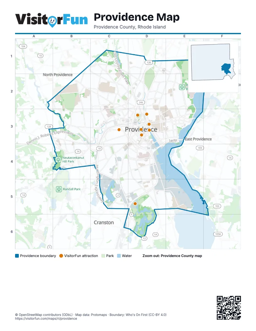
Street index of Providence
Each street on the sheet and the grid squares it crosses.
- Dennis J. Roberts ExpresswayA3, B3, C3, B4, C4
- Huntington ExpresswayC3, C4, C5, C6, D6
- Old Louisquisset PikeC1, C2, D2, D3
- 6/10 ConnectorC3
- IwayD3, E3, D4
- Grand Army of the Republic HighwayC3, D3
- East Providence ExpresswayE3
- I 95D5
- OldLouisquisset PikeC1, C2
- Elmwood AvenueC4, C5, D5, C6, D6
- North Main StreetD1, D2, D3
- Broad StreetD3, C4, D4, D5
- Eddy StreetD3, D4, D5
- Chalkstone AvenueB2, C2, D2, B3, C3
- Smith StreetB2, C2, D3
- Branch AvenueC1, D1, E1, D2
- Douglas AvenueC1, C2, D2
- Charles StreetC1, D1, D2, D3
- Allens AvenueD4, D5, E5
- Angell StreetD3, E3
- Waterman StreetD3, E3
- BroadwayC3, D3, C4
- Smithfield AvenueD1
- Washington StreetC3, D3
- Reservoir AvenueC5
- Point StreetD3, D4
- Thurbers AvenueD4, D5
- Memorial BoulevardD3
- Orms StreetD2, C3
- Wickenden StreetD3, E3
- Gano StreetE3
- South Water StreetD3, D4
- Franklin StreetD3, D4
- South Main StreetD3, D4
- Plain StreetD4
- Francis StreetD3
- Dorrance StreetD3
- Roger Williams AvenueC5, D5
- John J. Partington WayD3
- Canal StreetD3
- Dyer StreetD3
- Narragansett BoulevardE5
- East Franklin StreetD3, D4
- Randall StreetD2
- Fountain StreetD3
- Ashburton StreetD2
- Empire StreetD3
- Exchange TerraceD3
- Park AvenueD6
- Main StreetD3, D4
- Sabin StreetD3
- Mill StreetD3, D6
- Thomas StreetD3
- Steeple StreetD3
- Service RoadD3, D4
- Washington PlaceD3
- Blackstone BoulevardE1, E2, E3
- Hope StreetE1, D2, E2, D3, E3
- Manton AvenueB2, A3, B3, C3, C4
- Westminster StreetC3, D3, C4
- Admiral StreetB1, C1, C2, D2
- Huntington AvenueC4, C5
- Pleasant Valley ParkwayC2, C3
- Atwells AvenueB3, C3, D3
- Mount Pleasant AvenueB2, B3
- Plainfield StreetB4, C4
- Harris AvenueC3, D3, C4
- Union AvenueB4, C4
- Hartford AvenueA3, B3, B4, C4
- Valley StreetC3, C4
- Public StreetC4, D4
- Cranston StreetC3, C4
- Dean StreetC3, D3
- Killingly StreetA3, B3, B4
- Silver Spring StreetD1, D2
- Doyle AvenueD2, E2
- Pocasset AvenueB4
- Olney StreetD2, E2
- Kinsley AvenueC3
- Promenade StreetC3, D3
- Service Road 1C4, E5
- Clifford StreetD3, D4
- Tobey StreetC3, C4
- Henderson ParkwayE3
- Vermont AvenueD5, E5
- Park StreetD2, D3
- Glenbridge AvenueB3
- Messer StreetC4
- Fruit Hill AvenueB2
- Oakland AvenueC2
- Butler AvenueE3
- Weybosset StreetD3
- Sunset AvenueD2, B4
- Providence PlaceC3, D3
- Exchange StreetD3
- South Angell StreetE3
- Pontiac AvenueC5
- Greenwich StreetC4
- Gaspee StreetD3
- Raymond StreetC2, C3
- Woonasquatucket AvenueA2, B2
- Pike StreetD3
- Carter StreetC5
- Barton StreetC3, C4
- Duxbury StreetB4
- Hayes StreetD3
- Dyer AvenueB4
- Olneyville SquareC4
- River AvenueC1, D1, C2, D2, E2, C3
- Elmgrove AvenueE1, E2, E3
- Academy AvenueB2, C2, C3
- Prairie AvenueD4, D5
- Benefit StreetD2, D3
- Lloyd AvenueE2, D3, E3
- Dexter StreetC4
- Wayland AvenueE2, E3
- Eaton StreetB2, C2
- Friendship StreetD3, D4
- Camp StreetD2
- Rochambeau AvenueD2, E2
- Veazie StreetC1, C2
- Brook StreetD3
- Thayer StreetD3
- Laurel Hill AvenueB3, B4
- College RoadB2, C2
- Power StreetD3, E3
- Morris AvenueD2, E2
- Blackstone StreetD4
- Adelaide AvenueC5, D5
- Irving AvenueE2, E3
- Bucklin StreetC4, C5
- Hawkins StreetC1, D1, C2
- Woodward RoadC1
- Dupont DriveC4, C5
- Webster AvenueB4
- Chad Brown StreetC2
- Ernest StreetD5, E5
- Dudley StreetD4
- Ives StreetE3
- Governor StreetE3
- Portugal ParkwayE3, D4
- Pitman StreetE3
- Harbourside BoulevardE5
- Sackett StreetC5, D5
- Gentian AvenueB1, B2
- Knight StreetC3
- Bridgham StreetC3, C4
- West Exchange StreetC3, D3
- Shipyard StreetE5
- 5th StreetD1, E1, E2
- Cypress StreetD2
- Atlantic AvenueC5, D5
- Narragansett AvenueC5
- Terminal RoadD5, E5
- Richmond StreetD3, D4
- Niantic AvenueC4, C5
- River RoadE2, E3
- Orteleva DriveB3
- Chestnut StreetD3, D4
- Bath StreetC2, C3
- Holden StreetD2, D3
- Parade StreetC4
- Huxley AvenueC2
- Sessions StreetD2, E2
- Ledge StreetD1
- Silver Lake AvenueB4
- Petteys AvenueB3, B4
- Lockwood StreetD4
- Cemetery StreetD1, D2
- Murray StreetB4
- Delaine StreetC3
- Burns StreetB1, C1
- Borden StreetD4
- Cahir StreetD3, D4
- Terrace AvenueB4
- Eagle StreetC3
- Whipple StreetC2, D2
- Lubec StreetB1, C1
- Cathedral AvenueB2
- 7th StreetD1, E1
- Candace StreetC2, C3
- Aldrich StreetD5
- Ridge StreetC3
- Mathewson StreetD3
- Alfred Stone RoadE1
- Calverly StreetC3, D3
- Magnan RoadC4
- Overhill RoadE1
- State StreetD2, D3
- Stewart StreetD3, D4
- Acorn StreetC3
- College StreetD3
- Snow StreetD3
- Aleppo StreetB3
- Union StreetD3
- Bridge StreetD3, D4
- Swiss StreetC3
- O'Connell StreetD4
- East River StreetE3
- Appleton StreetC3
- Fricker StreetC3, C4, D4
- Park Row WestD3
- Rosebank AvenueC2
- Finance WayD3
- Hemlock StreetC3
- Frost StreetD1
- Tockwotton StreetD3, D4
- Rialto StreetB2
- Planet StreetD3
- Myrtle StreetC4, D4
- Frankfort StreetC5
- Stillman StreetD3
- Justice StreetC2
- Beulah StreetC1
- Earl StreetC5
- Park RowD3
- Packet StreetD3
- Wellington AvenueC5
- Prince StreetD4
- Frederick C Greene Memorial BoulevardD5, D6
- Potters AvenueC4, D4
- Cole AvenueE1, E2, E3
- Forest AvenueE1, E2
- Butler DriveE2
- Main AvenueD2
- Pine StreetD3, C4, D4
- Sharon StreetC1, C2
- Royal Little DriveD1, D2
- Slater AvenueE2
- Melrose StreetC4, C5, D5
- Oxford StreetD4
- Taber AvenueE2, E3
- Jastram StreetC2
- The Old RoadE1, E2
- Niagara StreetD4, D5
- Brown StreetD2, D3
- Cladrash's AvenueD5, D6
- Grotto AvenueE2
- Maple AvenueE1, D2, D5, D6
- New York AvenueD5, E5
- Lowell AvenueB3, B4
- Williams StreetD3, E3
- Ocean StreetD4, D5
- President AvenueE2
- Freeman ParkwayD2, E2
- Laurel AvenueE2
- Prospect StreetD2, D3
- Whitford AvenueB2, C2
- Nelson StreetC2
- Hamilton StreetC4, D5
- Pearl StreetC4, D4
- Carpenter StreetC3, D3
- George StreetD3, E3
- Langdon StreetC1
- Waverly StreetC4
- Warrington StreetC5, D5
- Althea StreetC4
- Summit AvenueD1, E1, D2
- Laban StreetB4
- Gallatin StreetC5, D5
- Waldo StreetC4
- 4th StreetD1, E2
- Meeting StreetD3
- Beach AvenueD1, E1, D2
- Montgomery AvenueD5, E5
- Arlington AvenueE2, E3
- Linwood AvenueC4
- Lynch StreetB3
- Sterling AvenueB4, C4
- West River StreetD2
- 8th StreetD1, E1
- Rankin AvenueC2, C3
- Regent AvenueC3
- Lenox AvenueC5, D5
- Virginia AvenueD5
- Cadillac DriveC5, D5
- Grove StreetC3
- Federal StreetC3, D3
- Baker StreetD5
- Carleton StreetB3
- Daboll StreetC4, D4
- Whittier AvenueB4
- Pavilion AvenueD2, D5
- Jewett StreetC3, D3
- Bowen StreetD3
- West Park StreetC3, D3
- Lorimer AvenueE1, E2
- Wallace StreetB4, C4
- Washington AvenueD5, E5
- Indiana AvenueD5, E5
- Ophelia StreetB3, B4
- Sayles StreetD4
- Carolina AvenueD5, E5
- University AvenueE2, E3
- Leah StreetB3
- Saratoga StreetD4
- Georgia AvenueD5, E5
- Amherst StreetB3, C3
- California AvenueD5, E5
- Toronto AvenueD5, E5
Things to do on the Providence map
Places on the map
- Annex Finance Post Office
- Annmary Brown Library
- Baileys Butts
- Berylson Family Fields
- Blackstone Boulevard Park
- Blackstone Park
- Branch Avenue Plaza
- Brown University
- Butler Hospital
- Canada Pond
- College Hill
- Cunliff Lake
- Downtown
- Edgewood Lake
- Elm Lake
- Fox Point
- Hasbro Children's Hospital
- Hospital Trust Building
- Jewelry District
- Johnson and Wales University Providence Downcity Campus
- Johnson and Wales University Providence Harborside Campus
- Mashapaug Pond
- Merino Park
- Moses Brown School
- Mount Pleasant High School
- Neutaconkanut Hill Park
- North Burial Ground
- Omni Providence Hotel
- Pleasure Lake
- Providence College
- Providence VA Medical Center
- Rhode Island Hospital
- Rhode Island School of Design
- Riverside Park
- Roger Williams Medical Center
- Roger Williams Park Zoo
- Sciences Library
- Swan Point Cemetery
- Triggs Memorial Golf Course
- Wayland
Next to Providence
- Cranston map
- East Providence
- North Providence
- Rumford
© OpenStreetMap contributors, Open Database License, openstreetmap.org/copyright · Map data: Protomaps · Boundary: Who's On First (CC-BY 4.0); U.S. Census Bureau