

Rhode Island map
Woonsocket map
About 44,508 people live here (Census Bureau, 2024 estimate). The sheet's index lists 300 streets; Mendon Road, Diamond Hill Road and Park Avenue cross the most grid squares. Things to do inside the boundary: World War II Veterans Memorial State Park.
Open the map (PDF, US Letter)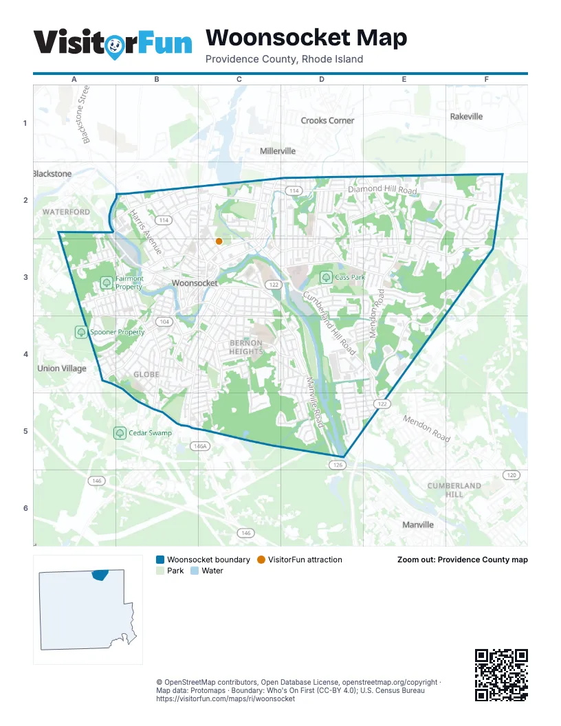
Street index of Woonsocket
Each street on the sheet and the grid squares it crosses.
- Woonsocket Industrial HighwayE5
- Mendon RoadE2, E3, E4, E5
- Diamond Hill RoadC2, D2, E2, F2
- Park AvenueC3, B4, C4, B5
- Cumberland Hill RoadC3, D3, D4, E4
- Social StreetC2, C3
- Clinton StreetC2, C3
- Hamlet AvenueC3, D3
- Cumberland StreetC3, D3
- Main StreetB3, C3
- Court StreetC3
- Highland Corporate DriveE5
- Manville RoadC3, D3, D4, D5
- South Main StreetB3, A4, B4
- Bernon StreetB3, C3, C4, D4
- Smithfield RoadA4, B4, B5
- Harris AvenueB2, B3
- Providence StreetB4, B5
- Winter StreetB2, C2
- Truman DriveB3, C3
- Rathbun StreetC2, C3
- Privilege StreetC2
- Arnold StreetB3
- High StreetB3, C3
- Greene StreetC3, C4
- Railroad StreetB3, C3
- Worrall StreetC3
- Great RoadA4
- Greenville RoadB5
- Park East DriveE3, F3, E4
- Logee StreetB4, C4, D4
- River StreetA2, B3
- Cass AvenueC3, D3, E3
- Elder Ballou Meeting House RoadE3, F3
- Elm StreetC2, C3, D3
- Front StreetC3, B4, C4
- Fairmount StreetA3, B3
- North Main StreetB2, C2, B3, C3
- Wood AvenueD2, D3
- 2nd AvenueB3, B4
- Blackstone StreetB3, C3
- Mason StreetA3, A4, B4
- Gaskill StreetB2
- Rhodes AvenueA3, B3
- Carrington AvenueC3
- Cottage StreetC3, C4
- Transit StreetB4
- Bound RoadF2, F3
- Beacon AvenueD2, D3
- Knight StreetC4
- Singleton StreetA2, B2
- Morin StreetD2, E2
- Carnation StreetC4, B5
- Bertenshaw RoadC4, D4
- Winthrop StreetD2, D3
- Dana StreetE3
- Campeau StreetD3, E3
- Saint Leon AvenueD2
- 9th AvenueA3, A4
- Canal StreetA2, B3
- Lefrancois BoulevardE3
- Locust StreetC3
- Monument SquareC3
- 3rd AvenueA2, A3, B3, B4
- Knollwood DriveE2, F2
- Grove StreetC3, C4
- Robinson StreetC2, D2, C3
- Jillson AvenueC4, C5
- Walnut Hill RoadF2
- Lydia AvenueD4, D5
- Prospect StreetB2, B3
- East School StreetB2, C2
- Aylsworth AvenueD3, E3
- Pond StreetC2, C3
- Grandview AvenueF2, F3
- Willow StreetC3
- Olo StreetA3, B3
- Coe StreetB4
- Dulude AvenueD2, D3
- Louise StreetD4, D5
- Woodland RoadB2, B3
- Ballou StreetB4
- Summer StreetB2
- Village RoadE2
- Congress StreetD3
- Burnside AvenueC2, D2, C3
- Morin Heights BoulevardD2
- Founders DriveD4, E4
- Oregon AvenueE3
- 4th AvenueA3, B3, B4
- Lucille StreetD4, D5
- Maple StreetC3, C4
- Orchard StreetB4
- Welles StreetC3, C4
- Vose StreetB4
- Cranston StreetC4, C5
- Bourdon BoulevardA4
- Paradis AvenueC3, C4
- Gauthier DriveC5, D5
- Mowry StreetB4, C4
- Ray AvenueD3, E3
- Talcott StreetE4, E5
- 6th AvenueA3, A4
- Saint Louis AvenueD2
- Avenue AB4, B5
- Olive StreetE4, E5
- Ward StreetB4
- Nursery AvenueE2, D3, E3
- Katherine RoadB2, B3
- Park PlaceC3
- Reservoir AvenueC4, D4
- Linden AvenueD2
- Adams StreetC2, D2
- Poplar StreetD2, E2, D3
- Highland StreetB2, B3
- Newland AvenueD3
- Sayles StreetB3
- Estes StreetC2, D2
- Getchell AvenueC4
- Grand StreetB4, C4
- Star AvenueF2
- 8th AvenueA3
- Bayberry RoadF2, F3
- Rock Ridge DriveE2
- Larch StreetD5, E5
- Asylum StreetA4, B4
- Burrington StreetD5, E5
- 1st AvenueB3
- Bennett StreetC3, C4
- Halsey RoadE2, F2, E3
- Patton RoadE2
- Saint Barnabe StreetD4
- Avenue CB4
- Nimitz RoadE2
- Phillips StreetD5, E5
- Joffre AvenueC4
- Lincoln StreetB4
- Jenckes StreetB4
- 7th AvenueA3, A4
- Newbury AvenueD4, E4
- Danielle StreetD5
- Madeleine AvenueE3
- Oakley RoadB2, B3
- Woodhaven RoadF2
- Chestnut StreetA3, B3
- Roberts StreetC3, C4
- Cato StreetB3, C3
- Glaude LaneF2
- 5th AvenueA3, B3, B4
- Cherry Hill AvenueA2, A3
- Hawthorne CircleD5
- Division StreetC4
- Bernice AvenueA4, B4
- Morse AvenueA4
- Cooper AvenueC4
- Marshall RoadE2, E3
- Tara LaneE3, F3
- Priscilla RoadE2, E3
- Theresa StreetE3
- Mount Saint Charles AvenueC4, D4
- Dawn BoulevardF2
- Alice AvenueA4
- Boyden StreetB3
- Holly LaneE3
- West School StreetB2, B3
- Crawford StreetC4
- Sunnyside AvenueA4, B4
- Annette AvenueE3
- Farm StreetB2, C2
- Huntington AvenueB2
- Virginia AvenueD4, E4
- Brookhaven LaneF3
- Capwell AvenueC4
- MacArthur RoadE2, E3
- Piedmont StreetB4
- Church StreetB3, C3
- Chapel StreetA3
- Flora AvenueD5
- Fairfield AvenueD4
- Cady StreetD3
- Progresso AvenueD2, D3
- Fortin DriveD4
- Papineau AvenueE2, E3
- Bailey StreetB4
- Harrison AvenueC3
- Davison AvenueC3, D3
- Elmore StreetB4, B5
- Glen RoadB2, B3
- Vivian StreetD5, E5
- CVS DriveE4
- Manila AvenueE3
- Saint Cecile AvenueD2
- Theresa Marie AvenueD2, E2
- Hemond AvenueB5, C5
- Saint Agnes AvenueD2
- Thibeault AvenueD4, D5
- Florence DriveC3
- Valley StreetB4
- Warwick StreetB5, C5
- Circle StreetD4
- Glendale AvenueD4
- Washington StreetC4
- Rivulet StreetB2
- Andrews StreetA4, B4
- Lemay RoadE3
- Country RoadF2
- Myette StreetD4
- Roberta AvenueA4, B4
- Earle StreetC3
- Rockland AvenueA4, B4
- Spring Water DriveE3
- Bernon HeightsC4
- Coolidge AvenueD2
- Hayes StreetD2
- Meadow RoadB2
- Mill StreetC2, D2
- Rebekah StreetB2, C2
- Pinecrest DriveD2, E2
- Bluestone DriveD5
- Morton AvenueC3
- Newton StreetE3
- Hazel StreetC2
- Spring StreetB2, B3
- Lilac AvenueD4, D5
- Rhode Island AvenueC4, D4
- Fournier AvenueB5, C5
- Hamilton StreetC4
- Pleasant StreetB4
- Center StreetB3, B4
- Monroe StreetC4
- Trent StreetB2
- Rutland StreetD2, D3
- Saint Augustin StreetD4
- Norman StreetD4, E4
- Stoneham DriveF2
- Langevin StreetE3
- Ridge StreetD3, E3
- Chester StreetC2
- Cote AvenueD3
- Saint Hughes StreetD4
- Thomas StreetB4
- Rustic DriveE2, F2
- Temple StreetB2
- Fisher StreetD4, E4, D5
- Hillview StreetC5
- 10th AvenueA3, A4
- Cleveland StreetC4
- Allen StreetB3, C3
- Mitris BoulevardE2, E3
- Oakton StreetB4, C4
- Hebert AvenueD3
- Monty AvenueB5, C5
- Minerva StreetB4
- Rodman StreetE3
- Avenue BB4
- Bertha AvenueD4, D5
- Bourassa AvenueE2, E3
- Ledgewood LaneF3
- Verry StreetB3
- Snow StreetC3
- Grace StreetD3
- Pine StreetC4
- Summit StreetB4
- Jervis StreetD3
- Atlanta AvenueD2
- Beausoleil AvenueE5
- Daniels StreetC2, C3
- Fountain StreetB3
- Oak StreetB3, B4
- Newport StreetB5, C5
- Hope StreetB3
- Lyman StreetB3
- South StreetB3, B4
- Roland StreetC2
- Sweet AvenueD3
- Marian LaneD5
- Angell StreetC4
- Diana DriveE2, F2
- Irene BoulevardB4
- Beech StreetB4
- Lambert AvenueE3
- Water StreetB3
- Williams StreetC4
- West StreetB3
- Merida AvenueD2, D3
- Dudley StreetE3, E4
- All Saints StreetD2
- Bellingham StreetD2
- Gadoury BoulevardD5
- Nancy CourtD4, E4
- East StreetB3, B4
- Kenwood StreetE3
- Denby StreetD2
- Miles AvenueD4, D5
- Gaulin AvenueC3
- Prince StreetD2
- Broad StreetB4
- Sycamore StreetA3
- Wilcox StreetD2, E2
- Kermit StreetC4
Things to do on the Woonsocket map
Places on the map
- Applebee's
- Barry Field
- Bernon Heights School
- Bernon Memorial Park
- Blackstone River
- Boys & Girls Club
- Cass Park
- Cass Park Center Woonsocket Head Start
- Cass Park Pond
- Citizen's Memorial Elementary School
- Cobble Hill
- Cold Spring Park
- Cook Cemetery
- Costa Park
- CubeSmart
- Cumberland Farms
- CVS Pharmacy
- Darling Pond
- Dollar General
- Dunkin'
- Dunn Park
- Fairmont Property
- First Baptist Church
- Friendly Nursing Home
- Globe Park
- Globe Park Elementary School
- Landmark Medical Center
- Lemourex Field
- Mount Saint Charles School
- North End Historic District
- Oak Hill Cemetery
- River's Edge Recreation Complex
- Sylvestre Pond
- The Island
- Walnut Hill Station Post Office
- Woonsocket High School
- Woonsocket Middle Schools
- Woonsocket Post Office
- World War II Veterans Memorial State Park
Next to Woonsocket
- Blackstone
- Crooks Corner
- Cumberland Hill
- Manville
- Millerville
- Rakeville
- Union Village
- Waterford
© OpenStreetMap contributors, Open Database License, openstreetmap.org/copyright · Map data: Protomaps · Boundary: Who's On First (CC-BY 4.0); U.S. Census Bureau















