

South Carolina map
Cherokee County map
About 57,770 people live here (Census Bureau, 2024 estimate). The sheet's index lists 300 streets; Wilkinsville Highway, Pacolet Highway and Corinth Road cross the most grid squares. Things to do inside the boundary: Cowpens National Battlefield and Peachoid.
Open the map (PDF, US Letter)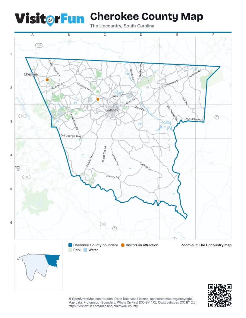
Street index of Cherokee County
Each street on the sheet and the grid squares it crosses.
- Union HighwayC3, C4, C5
- Chesnee HighwayA2, B2, C2
- Old Georgia HighwayB3, C3
- East Cherokee StreetE1, E2
- York RoadE2, E3
- Shelby HighwayD1, D2
- Cherokee AvenueD2, C3, D3
- West Cherokee StreetD2, E2
- North Mountain StreetE1, E2
- Cliffside HighwayA1, B1, A2
- North Limestone StreetC2, C3
- East Frederick StreetC3
- Kings Creek DriveE3, F3
- Highway 221 SouthA1, A2
- Highway 11 EastA2
- West Floyd Baker BoulevardC2, C3
- North Logan StreetC2, C3
- Old Shelby RoadC2, D2
- South Granard StreetC3
- North Granard StreetC2, C3
- West Frederick StreetC3
- Hampton StreetA2
- Clover HighwayF3
- Gaffney HighwayC5
- South Lafayette StreetD1
- Wilkinsville HighwayC3, D3, D4, E4, E5
- Pacolet HighwayC3, B4, C4, B5
- McKowns Mountain RoadD3, E3, E4
- Victory Trail RoadD2, D3
- Boiling Springs HighwayC1, C2
- Battleground RoadF1, A2, A3
- Asbury RoadB4, C4, C5
- Gowdeysville RoadC5, D5
- Hickory Grove RoadD5, E5
- Hyatt StreetC2, C3
- Rock Cut RoadE3, F3
- Skull Shoals RoadD5
- College DriveC3
- Providence RoadC2, C3
- South Limestone StreetC3
- Corry StreetE2, C3
- Battleground DriveF1, F2
- Union StreetC3
- East O'Neal StreetC3
- East Rutledge AvenueC3
- Gaffney RoadC1
- Holland StreetC3
- North Main StreetE1, F3
- Blacksburg RoadE1
- Mount Tabor Church RoadD5
- Corinth RoadC4, D4, D5, E5
- Old Post RoadB2, C2, B3
- Love Springs RoadB3, C3
- Overbrook DriveB3, C3
- Twin Bridge RoadB1, C1, C2
- Bonner RoadA2, B2
- Pleasant School RoadC2, D2
- Brick House RoadC4, D4
- Ford RoadD3
- McGill HighwayE3, F3
- Cowpens Pacolet RoadB4, B5
- Wilcox AvenueC2, D2
- Quarter Round RoadB4, C4, B5, C5
- Oak Ridge RoadC1, C2
- North Green River RoadA1, B1, B2
- South Green River RoadB3
- Green River RoadB2, B3
- State Line RoadB1
- Possum Trot RoadE2, F2
- South Rutherford StreetE2, E3
- Dravo RoadD1, D2
- Elbethel RoadD4, C5, D5
- Ellis Ferry RoadC1, C2
- Old Metal RoadA2, B2
- White Plains RoadB3, B4
- Cherokee National HighwayB1, B2, C2
- Buck Shoals RoadB1, B2
- Swofford DriveA2, B2, B3
- Patrick RoadD3, D4, E4
- Old Chester RoadE2, E3
- Robbs School RoadB1, C1, B2
- Cannons Campground RoadB3
- Antioch RoadF1, E2, F2
- Blacksburg HighwayD2
- Concord RoadC2, D2
- Sunny Slope DriveB3
- Macedonia RoadA2, B2, B3
- Webber RoadB3
- Smith Ford RoadD4, E4
- Fairview RoadB2
- Hamrick StreetC3
- Grassy Pond RoadB2, C2
- Darwin RoadD3, D4
- Holly Ridge RoadE1
- Jumping Branch RoadE2
- Batchelor DriveE2, D3, E3
- West Rutledge AvenueC2, C3
- Bridges RoadD1, D2
- Rock Springs RoadD1, D2, E2
- West Buford StreetC2, C3
- Windslow AvenueC2, C3
- River DriveD2, D3
- Keg Town Mill RoadA1
- Champion Ferry RoadB1, B2
- Beason RoadB1
- Mill Creek RoadE1, E2
- Peachoid RoadC2
- Old Buffalo Church RoadD1, D2
- Tribal RoadE1, E2
- Bear Creek RoadD3, E3
- Draytonville RoadD3
- Ashworth School RoadB1, B2
- Shady Grove RoadB2
- North Gate RoadC2
- Leagan DriveD2, E2, E3
- Whites Farm RoadE1, E2
- Hetty Hill StreetC3, D3
- Beech StreetC3, D3
- River RoadD2, D3, E3
- Grambling Ferry RoadC2
- Quarry RoadE1, E2
- Park Gate RoadA2, B2
- Hampshire DriveC2
- Green Acres RoadB2, B3
- Gaffney Ferry RoadD2
- Cash RoadB2
- Martin Hill RoadD2, E2
- Henson RoadD2, E2
- Gold Mine RoadD3
- East Junior High RoadC3, D3
- Piedmont RoadA2
- Morgan DriveC3
- Young Grove RoadD2
- Linder RoadB2
- Island Creek RoadA2
- Oglesby Valley RoadB2
- Indian Springs RoadF2, F3
- East Oneal StreetC3
- Blackwell RoadD2
- Edgewater DriveC3
- Woods Farm RoadA2
- Cashs Peach RoadA3, B3
- Twin Lake RoadC3
- Canaan Chruch RoadF3
- Allison Creek RoadC2
- Nancy Creek RoadB2, C2, B3, C3
- Baker RoadC3
- North Shelby StreetD2, E2
- Moss Farm RoadD1, D2
- Sarratt Creek RoadB1
- Shaman RoadE2
- Dry Fork RoadD4
- New Pleasant RoadA2, B2
- Railroad AvenueD2, E2, C3
- East Buford StreetC3
- Old Pros DriveC2
- Lockhart LaneC2
- East Oconee StreetA1, A2
- Bowen River RoadD1
- Windhill RoadD2
- Mulberry RoadE1
- Moss CrossingD2
- Lemmons LaneC3
- Turner RoadD2
- Whelchel RoadC2
- Bailey Bridge RoadB2
- West Montgomery StreetC3
- 6th StreetC2, C3
- Bluebird LaneE2
- Bonner Lake RoadC2, D2
- Moda RoadD2
- West Carolina StreetD2, E2
- East Cudd RoadA2
- 10th StreetC2, C3
- 13th StreetC3
- Estes RoadC2
- Hayes RoadB2
- Marietta StreetD3
- Colonial AvenueC3
- Peoples Creek RoadD3
- Ballfield RoadE2
- Daniel Morgan School RoadB2
- 4th StreetC2, C3
- Speedway RoadD2
- Pickens StreetA2
- Twin Lakes RoadC3
- Gaston Farm RoadD1
- Matthew DriveC2
- North Mountain Street ExtensionE2
- Pickle Springs RoadA2
- Chandler DriveC3
- South Logan StreetC3
- Beltline RoadC2
- Pauls RoadB1
- East Montgomery StreetC3
- Ellis Ferry AvenueC2
- Dr Martin Luther King DriveC3
- Midway TerraceC3
- Midway RoadC3
- Green Lake RoadA2
- Triangle RoadD4
- Stacy DriveC3
- East Floyd Baker BoulevardC3
- Jennies LaneC2
- Pecan StreetC3
- West O'Neal StreetC3
- East 3rd StreetC3
- Draytonville Church RoadD3
- Young StreetC2, C3
- Club House DriveC2
- Griffith StreetC3
- Allison DriveC2
- Overhill DriveD2, D3
- Mimosa DriveC2
- 3rd StreetC2, C3
- Worthmore DriveC3
- Noble RoadB2
- Corona DriveC2
- Waterson RoadE1
- East Carolina StreetE2
- West 3rd StreetC2
- Gordon RoadC2
- Phillips DriveB1, B3
- Madison AvenueC3
- Swofford TrailC2
- North Alabama AvenueA1
- Walker Farm RoadE5, E6
- Burnt Gin RoadC4
- Goucher School RoadB4, C4
- Littlejohn RoadC5, D5
- Ninety Nine Island RoadE2, E3
- Goucher Green Bethel RoadB4, C4
- Leadmine RoadC3
- Carolina Ridge RoadB1, B2
- Lookout Tower RoadE2, F2
- Starr Ridge RoadC4, D4
- Billy Goat Bridge RoadD4, D5
- Burnt Mill RoadE2, F2
- Abingdon RoadE4
- Hopewell RoadE2, E3
- Cherokee Falls RoadD2, D3
- Potter RoadB2
- Pondfield RoadD3, D4
- Caldwell RoadF2, E3, F3
- Holly Grove RoadE1, E2
- Commerce DriveD2
- Battleground Tour RoadA2, B2
- Lowrys RoadD4
- Smoke Ridge RoadC4, D4
- Beaver Dam RoadB3, C3
- Double Bridge RoadB3, B4, C4
- Wofford RoadD4, E4
- Walker RoadE3
- Chestnut Ridge RoadC3, D3
- Whites RoadD3
- Old Race Track RoadC3
- Crenshaw RoadB3, B4
- Little Hope RoadD2
- South Charleston StreetE2
- Sarratt School RoadB3
- Mullinax CircleE2
- Dam RoadE3
- Oak Dale RoadB3, B4
- Owensby StreetE3
- Peeler Creek RoadD3
- Childers RoadD3, C4, D4
- Rock House RoadF1, F2
- Soap Stone RoadB4
- Blue Branch RoadC3, C4
- Ross Hill RoadC1, C2
- Round Tree RoadC4
- Dulin RoadE2, E3
- Ballenger RoadC3, C4
- Silica Springs RoadC4
- Farmington RoadB2, C2
- Covered Bridge RoadD5
- Ross RoadD1
- West Pine StreetD2, E2
- Old Factory RoadD3, E3
- Mayfield RoadD5
- Grindall Ford RoadC5
- North Cherokee Ford RoadE2
- Island Ford RoadA1
- Sardis RoadE3, E4
- Dillon StreetA2
- Phillips CircleC4, C5
- Oglesby LaneB3
- Hames RoadD5
- Horse Creek RoadA1, A2
- Moss TrailD3, E3
- Garner Creek RoadF2
- Roland Farm RoadB4, C4
- Mikes Creek RoadC1
- Fortanberry RoadC4
- Mill Gin RoadB2
- Dawkins RoadC4, C5
- Thompson StreetC3
- Garvin Lake RoadC3
- Little Egypt RoadB3
- South Johnson StreetC3
Things to do on the Cherokee County map
Places on the map
- BD Lee Elementary School
- Blacksburg
- Blacksburg Post Office
- Blacksburg Primary School
- Blacksburg Quarry
- Broad River Mine
- Browns Mountain
- Camp Sparrow RV Resort
- Cherokee Ford Recreation Area
- Cherokee Medical Center
- Cherokee National Golf & Recreation Club
- Cherokee Plaza
- Cherokee Speedway
- Cherokee Super Speedway
- Chesnee Country Club
- Clingham Memorial Cemetery
- Corinth Elementary School
- Country Club of Gaffney
- Cowpens Battlefield RV Park
- Cowpens National Battlefield
- DHL
- East Gaffney
- Fox Hollow Farm
- Frederick Memorial Gardens
- Gaffney
- Gaffney Outlet Marketplace
- Gaffney Senior High School
- Hammett Lake
- Lake Cherokee
- Lake Whelchel
- Limestone Quarry
- Oakland Cemetery
- Peachtree Marketplace
- Piedmont Plaza
- Shoppes At Gaffney
- Thicketty Creek Watershed 25 Reservoir
- Thicketty Creek Watershed Number
- Thicketty Creek Wcd Lake Number 26
- Watershed Number 16A Reservoir
- Watershed Number 18 Reservoir
Next to Cherokee County
- Chesnee
© OpenStreetMap contributors, Open Database License, openstreetmap.org/copyright · Map data: Protomaps · Boundary: Who's On First (CC-BY 4.0); Quattroshapes (CC BY 2.0)