

South Carolina road map
South Carolina highway map
11 Interstate routes run about 837 miles in South Carolina, each on a sheet of its own. The sheet's index lists 29 highways; I-26, I-95 and I-20 cross the most grid squares. Towns on it: Charleston, Columbia and Rock Hill.
Open the map (PDF, US Letter)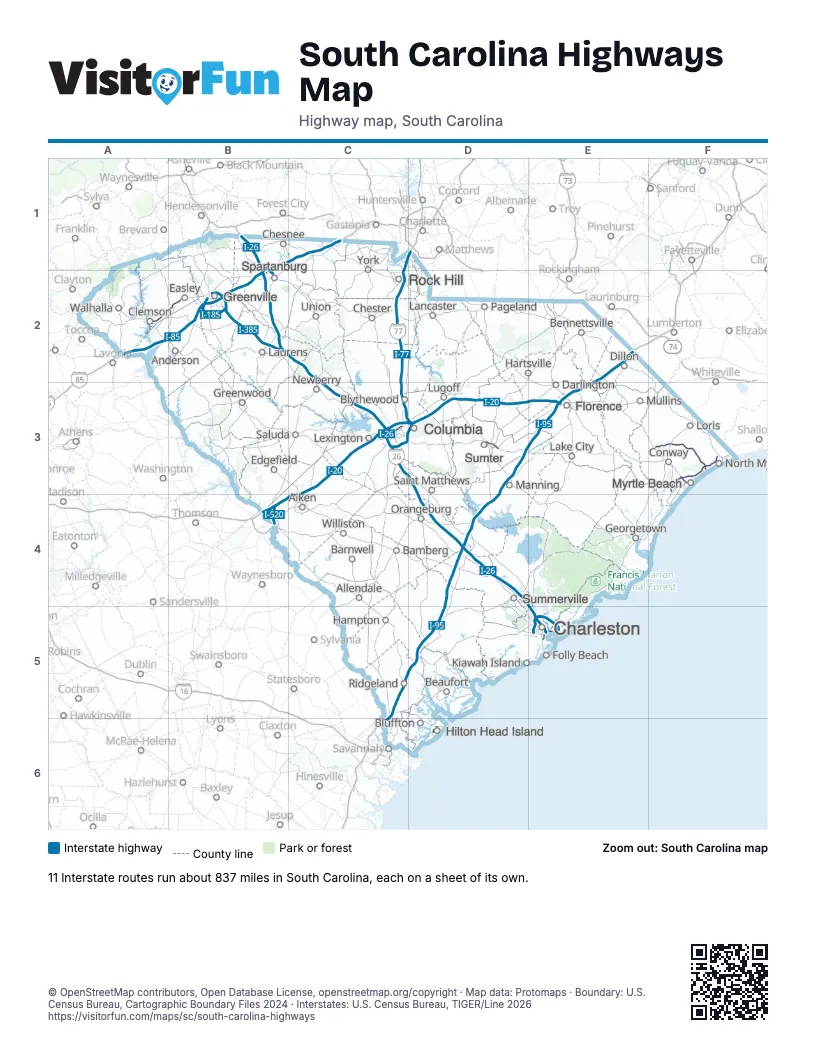
Road maps of South Carolina
10 road maps: each Interstate and byway on a sheet of its own.
Highway index of South Carolina
Each highway on the sheet and the grid squares it crosses.
- I-20B4, C3, C4, D3, E3
- I-26B1, B2, C2, C3, D3, D4, E4, E5
- I-77C1, C2, C3, D1, D3
- I-85A2, B1, B2, C1
- I-95C5, C6, D3, D4, D5, E2, E3
- I-126C3
- I-185B2
- I-385B2
- I-520B4
- I-526E5
- I-585B1, B2
- US 15D4
- US 17C5, D5, E5
- US 21D1
- US 29B2
- US 76C3, D3
- US 123A2, B2
- US 176B1, B2
- US 276B2
- US 278D6
- US 301D4
- US 378D3
- US 501F3
- SC 14B2
- SC 22F3
- SC 30E5
- SC 31F3
- SC 277C3
- SC 703E5
Places on the map
- Aiken
- Allendale
- Anderson
- Bamberg
- Barnwell
- Beaufort
- Bennettsville
- Bluffton
- Blythewood
- Charleston
- Chesnee
- Chester
- Clemson
- Columbia
- Conway
- Darlington
- Dillon
- Easley
- Edgefield
- Florence
- Georgetown
- Greenville
- Greenwood
- Hampton
- Hartsville
- Hilton Head Island
- Kiawah Island
- Lake City
- Lancaster
- Laurens
- Lexington
- Loris
- Lugoff
- Manning
- Mullins
- Myrtle Beach
- Newberry
- North Myrtle Beach
- Orangeburg
- Pageland
- Ridgeland
- Rock Hill
- Saint Matthews
- Saluda
- Spartanburg
- Summerville
- Sumter
- Union
- Walhalla
- Williston
- York
© OpenStreetMap contributors, Open Database License, openstreetmap.org/copyright · Map data: Protomaps · Boundary: U.S. Census Bureau, Cartographic Boundary Files 2024 · Interstates: U.S. Census Bureau, TIGER/Line 2026