

South Dakota map
Rapid City map
About 79,894 people live here (Census Bureau, 2024 estimate). The sheet's index lists 300 streets; Mount Rushmore Road, Catron Boulevard and Sheridan Lake Road cross the most grid squares. Things to do inside the boundary: Belle Joli Winery, Dinosaur Park and Firehouse Brewing Company.
Open the map (PDF, US Letter)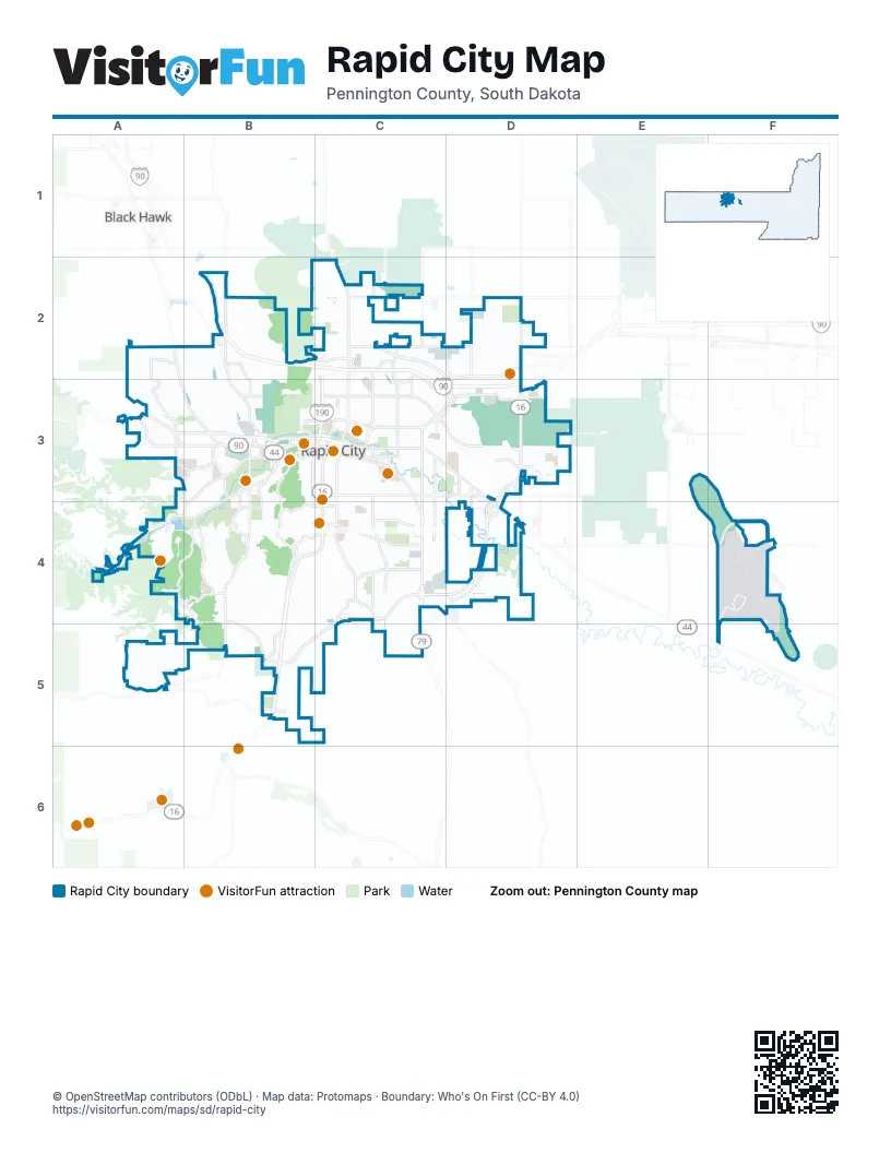
Street index of Rapid City
Each street on the sheet and the grid squares it crosses.
- Mount Rushmore RoadC3, B4, C4, B5
- Elk Vale RoadD3, C4, D4
- Catron BoulevardB4, C4, B5, C5
- West Chicago StreetA3, B3
- Cambell StreetC3, C4
- West Main StreetA3, B3, C3
- Jackson BoulevardB3, A4, B4
- East North StreetD2, C3, D3
- West Omaha StreetB3, C3
- West BoulevardB3, C3, C4
- Sturgis RoadA2, A3, B3
- East Catron BoulevardC4
- East Highway 44C3, D3, D4
- Saint Joseph StreetB3, C3, C4
- Omaha StreetC3
- North Elk Vale RoadD2, D3
- Airport RoadF4, F5
- Mountain View RoadB3, B4
- East Saint Joseph StreetC3, C4
- Terminal RoadF4
- East Omaha StreetC3
- Main StreetC3
- West Highway 44A4
- East BoulevardC3
- East Boulevard NorthC3
- East Main StreetC3
- North Cambell StreetC3
- South Highway 79C4, C5
- Echo Ridge DriveB4, C4
- South Highway 16B5
- SD Highway 44D4
- Sheridan Lake RoadB3, B4, A5, B5
- East Mall DriveC2, D2
- 5th StreetC3, C4, C5
- Haines AvenueC2, C3
- East Anamosa StreetC3, D3
- East Saint Patrick StreetC3, D3
- Deadwood AvenueB2, B3
- North LaCrosse StreetC2, C3
- Country RoadC2, D2
- Deadwood Avenue NorthB2
- South Canyon RoadA3, B3
- Saint Patrick StreetB3, C3
- Anamosa StreetC3
- Mall DriveC2
- Nickel StreetC2, C3
- North StreetC3
- North 5th StreetC3
- LaCrosse StreetC3
- Founders Park DriveB3
- West North StreetB3, C3
- North Mount Rushmore RoadC3
- Cathedral DriveC4
- Eglin StreetC2, C3, D3
- Skyline DriveB3, B4
- Canyon Lake DriveB3, A4, B4
- Elm AvenueC3, C4
- Maple AvenueC3, C4
- East Minnesota StreetC4, D4
- North Maple AvenueC2, C3
- Seger DriveC2, D2
- Long View RoadF4
- Tower RoadB4, C4
- Creek DriveC3, C4, D4
- Homestead StreetD3
- Dyess AvenueD2, D3
- City Springs RoadA2, A3
- Service RoadB3, B4, C4, B5
- Enchantment RoadB4, C4
- Park DriveB4
- Quincy StreetB3, C3
- Flormann StreetB4, C4
- Parkview DriveC4
- East Oakland StreetC4
- Cliff DriveA4, B4
- Carriage Hills DriveA4, B4
- East Fairmont BoulevardC4
- Wonderland DriveB4
- Marlin DriveC4, D4
- Enchanted Pines DriveB4, C4
- Concourse DriveD3
- 3rd StreetC3, C4
- Disk DriveC2
- Corral DriveA4, B4
- Franklin StreetB3, C3
- North 7th StreetC2, C3
- Chapel LaneA4
- North Creek DriveC3, D3
- Rand RoadB2, B3
- West Flormann StreetB4
- 44th StreetA3
- North Plaza DriveB2
- 32nd StreetB3
- Fairmont BoulevardB4, C4
- Canyon DriveA4, B4
- East Madison StreetC3
- Promise RoadB5
- 143rd AvenueC2
- Minnesota StreetC4
- West Nike RoadC2
- Hillsview DriveA3, B3, B4
- Sioux San DriveB3
- Sedivy LaneD3
- South Berry Pine RoadA3
- Range RoadB3
- Reservoir RoadD3
- Central BoulevardB3, B4
- Raider RoadA3, B3
- Arrowhead DriveB4
- Saint Martins DriveA2
- Country Club DriveB4
- Cheyenne BoulevardD3
- East Main Street NorthC3
- Luna AvenueC2, C3
- Moon Meadows DriveB5
- South Valley DriveD3, D4
- East Disk DriveC2
- Falls DriveB4
- Commerce RoadB3
- Tish BoulevardD2
- North Berry Pine RoadA3
- Howard StreetC2
- Red Dale DriveA3, A4, B4
- Universal DriveB2
- West StreetB3
- Steele AvenueC3
- Dakota DriveB3
- Jubilee LaneD3
- North 44th StreetA3
- Saint Onge StreetB3
- Tablerock RoadB4, B5
- Sheffer StreetB3
- Audubon CircleA3
- Cross StreetB3
- Dan Christy LaneC4
- Wonderland CutoffB4
- Twilight DriveD4
- East Philadelphia StreetC3, D3
- Jolly LaneD3, D4
- North Valley DriveD3
- Wildwood DriveB4, B5
- 7th StreetC3, C4
- Wisconsin AvenueC4
- 6th StreetC3, C4
- Kansas City StreetB3, C3
- 9th StreetC3, C4
- Muirfield DriveA5
- Herman StreetC2, C3
- Alta Vista DriveB4, C4
- Centre StreetC3, D3
- 38th StreetB3, B4
- Columbus StreetB3, C3
- Harmony Heights LaneB2, C2, B3
- Stumer RoadC4
- Milwaukee StreetC3
- Ivy AvenueC3, C4
- Van Buren StreetB3, C3
- Prestwick RoadA5
- 11th StreetB3
- Saint Andrew StreetB3, C3
- Saint Cloud StreetB3, C3
- Saint Charles StreetB3, C3
- Hall StreetA3, B3
- East Saint Francis StreetC3, D3
- East Meade StreetC4
- West Rapid StreetB3
- Adams StreetC3
- Oak AvenueC3, C4
- Racine StreetC3
- East New York StreetC3
- Hidden Valley RoadA2
- Cherry AvenueC3, C4
- Coal Bank DriveB2, C2
- East Saint Charles StreetC3, D3
- Saint Francis StreetB3, C3
- Saint Anne StreetB4, C4
- Kingswood DriveA3
- Brookside DriveA3, B3
- Copperfield DriveD3
- Cowboy Hill RoadB3
- Sammis TrailB5
- Wood AvenueC2, C3
- South StreetB3, C3
- East Tallent StreetC4
- Meadowbrook DriveB4
- Nugget Gulch RoadB4, B5
- Cobalt DriveC2
- Willowbend RoadD4
- Hoefer AvenueC4
- East Chicago StreetC3
- Chalkstone DriveC2
- East Adams StreetC3
- East Watertown StreetC3
- Dunsmore RoadA5
- Pinedale Heights DriveA3
- Degeest DriveD3
- East Centennial StreetC4
- Pevans ParkwayB4
- 12th StreetB3
- Indiana StreetC4
- Tanager DriveA5
- Field View DriveC4
- Bunker DriveC2
- Meadowlark RoadC3
- East Denver StreetC3
- Waterloo StreetC3
- East Indiana StreetC4
- Bengal DriveC2
- University LoopC3
- West Saint Louis StreetA3, B3
- Oakland StreetC4
- Fulton StreetB3, C3
- Red Rock Canyon RoadA4
- Wambli DriveC2
- Clark StreetB3, C3
- Samco RoadB2, B3
- Summerfield DriveD3
- Summerset DriveB4
- Tomahawk DriveB4
- Fox Run DriveB4, C4
- East Saint Andrew StreetC3, D3
- Woodridge DriveB4, C4
- Meade StreetC4
- Misty Woods LaneC2
- Horse Creek RoadB4
- Cruz DriveB3, B4
- Texas StreetC4
- Powderhorn DriveA4
- Michigan AvenueC4
- Monroe StreetC3
- Pine StreetC2, C3
- Sioux AvenueC3, C4
- Energy Park DriveB5
- Cleveland StreetC4
- Bendt DriveB4, B5
- Saint James StreetB3, C3
- 1st StreetC3
- East Liberty StreetC4
- 4th StreetC3
- Grandview DriveC4
- Diamond Ridge BoulevardD3
- Mountain Meadow RoadB4
- Fountain Plaza DriveB2, B3
- East Monroe StreetC3
- Northridge DriveC2
- Spring Brook RoadB4
- Mickelson DriveD3
- Evergreen DriveB3, B4
- Panorama CircleB4, B5
- Augusta DriveD4
- Robbinsdale Park RoadC4
- Tatanka RoadB2
- Range View CircleC4
- Healing WayB5
- East Ohio StreetC4
- Cog Hill LaneA5, B5
- Highland Park DriveB4, C4
- College AvenueC3
- West Boulevard NorthC3
- Chief DriveC2
- East Stumer RoadC4
- New York StreetC3
- Willsie AvenueC3
- Neel StreetD3
- Avenue AD3
- Portrush RoadA5, B5
- Meadowlark DriveA5
- Fairview StreetB3, C3
- East Saint Anne StreetC4
- US Highway 16 Service RoadB5
- North Turbine DriveD3
- Elderberry BoulevardD4
- Country Road WestC2
- San Marco BoulevardA3
- East Elk StreetC4
- Pine Hills DriveA3, B3
- Viking DriveC2
- Edwards StreetD3
- Patricia StreetD3
- City View DriveB4, C4
- Willow AvenueC4
- San Francisco StreetC3
- Fairway Hills DriveB4
- Pinedale CircleA3
- Camden DriveC3
- Allen AvenueC3
- Brooke StreetC2
- Magic Canyon RoadA4
- Knollwood DriveC2
- Halley AvenueC3
- Minnekahta DriveA4, B4
- North Spruce StreetC3
- Turbine DriveD3
- MacArthur StreetC3
- Ridgeview RoadB4, C4
- Riley AvenueC3
- Farlow AvenueC3
- Foothill DriveB4
- Ping DriveD4
- Prairie AvenueC3, C4
Things to do on the Rapid City map
Places on the map
- Arrowhead Club
- Baken Park
- Best Western Ramkota Hotel
- Black Hills Surgical Hospital
- Braeburn Park
- Camp Rapid
- Canyon Lake
- Canyon Lake Park
- Central High School
- Chuck Lien Family Park
- Cleghorn Springs State Fish Hatchery
- Corral Drive Elementary School
- Cowboy Hill
- Dakota Drive Park
- Dakota Fields Soccer Complex
- Dinosaur Park
- East Middle School
- Echo Ridge
- Elks Golf Course
- Executive Golf Course
- Founders Park
- General Beadle Elementary
- Grandview Elementary
- Hanson-Larsen Memorial Park
- Lien Lake
- Meadowbrook Golf Course
- Memorial Park
- North Loop
- North Middle School
- Rapid City Regional Airport
- Rapid City Solid Waste
- Rapid City West Boulevard Historic District
- Robbinsdale Park
- Roosevelt Park
- Rushmore Mall
- Sioux Park
- Stevens High School
- The Outdoor Campus-West
- Uptown Rapid
- West Middle School
Next to Rapid City
- Black Hawk
- Box Elder
© OpenStreetMap contributors, Open Database License, openstreetmap.org/copyright · Map data: Protomaps · Boundary: Who's On First (CC-BY 4.0); U.S. Census Bureau