

South Dakota map
Pennington County map
About 115,979 people live here (Census Bureau, 2024 estimate). The sheet's index lists 300 streets; Main Street, East Highway 44 and Highway 1416 cross the most grid squares. Things to do inside the boundary: 1880 Train, Badlands National Park and Bear Country USA.
Open the map (PDF, US Letter)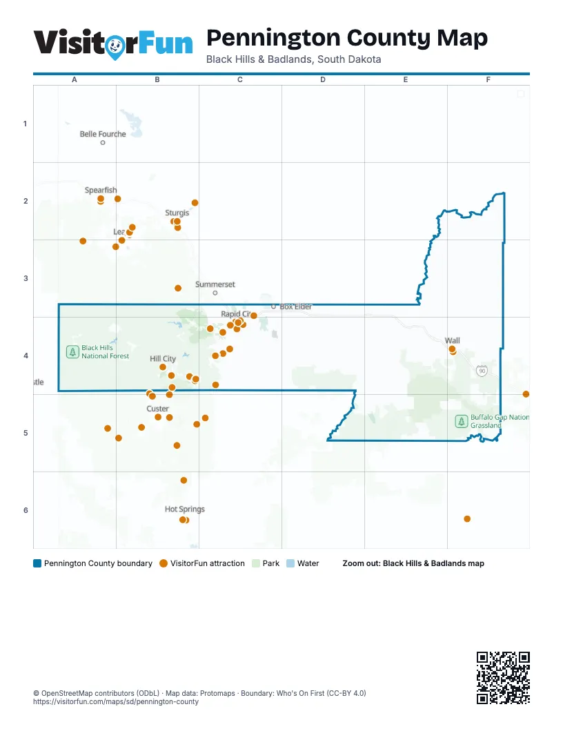
Maps inside Pennington County
1 map inside, from the street map of Pennington County down.
Street index of Pennington County
Each street on the sheet and the grid squares it crosses.
- East Highway 44C4, D4, E4, E5, F5
- Highway 1416C3, D3, D4, E4
- South Highway 16B4, C4
- Highway 385B3, B4
- South Highway 79C4
- Highway 240F4, F5
- West Highway 44B3, B4, C4
- Mount Rushmore RoadC4
- Elk Vale RoadC4
- US Highway 14F4
- SD Highway 244B4
- Catron BoulevardC4
- South Rockerville RoadC4
- Main StreetC3, B4, C4, D4, F4, E5
- Sturgis RoadC3, C4
- West Chicago StreetC4
- Cambell StreetC4
- West Main StreetC4
- Jackson BoulevardC4
- Highway 244B4
- Highway 16AB4
- North Elk Vale RoadC3, C4
- East North StreetC3, C4
- West Omaha StreetC4
- West BoulevardC4
- East Catron BoulevardC4
- Airport RoadC4, F4
- Liberty BoulevardC3
- Saint Joseph StreetB4, C4
- Omaha StreetC4
- Mountain View RoadC4
- North Ellsworth RoadC3
- East Saint Joseph StreetC4
- South Ellsworth RoadC3
- Terminal RoadC4
- East Main StreetB4, C4
- Glenn StreetF4
- West 4th AvenueF4
- South Boulevard WestF4
- East Omaha StreetC4
- East BoulevardC4
- South BoulevardF4
- East Boulevard NorthC4
- Railroad AvenueB4
- North Cambell StreetC4
- Winter StreetB4
- Echo Ridge DriveC4
- US Highway 385B3
- SD Highway 44C4
- Sheridan Lake RoadB4, C4
- 173rd AvenueE3, E4, E5
- Nemo RoadB3, C3, C4
- Highway 40C4
- Country RoadC3
- Radar Hill RoadC3, C4
- East Mall DriveC3
- Iron Mountain RoadB4
- 5th StreetC4
- Haines AvenueC3, C4
- Highway 87B4
- East Anamosa StreetC4
- South Canyon RoadC4
- Deadwood AvenueC3, C4
- East Saint Patrick StreetC4
- North LaCrosse StreetC3, C4
- Deadwood Avenue NorthC3
- Saint Patrick StreetC4
- West Gate RoadC3
- Anamosa StreetC4
- Mall DriveC3
- 1st StreetB4, C4, D4, E5
- Madill StreetB4, C4
- Nickel StreetC3, C4
- North StreetC4
- North 5th StreetC4
- LaCrosse StreetC4
- Founders Park DriveC4
- West North StreetC4
- Reed StreetB4
- North Mount Rushmore RoadC4
- Cathedral DriveC4
- SD Highway 40C4
- Doane Robinson TunnelB4
- Radar Hill Road / Gumbo DriveC3
- SD Highway 87B4
- Creighton RoadF2, F3, F4
- Sage Creek RoadE4, F4, E5
- Big Foot RoadF3, F4, F5
- Boles Canyon RoadA3, A4
- Base Line RoadD4, E4
- Pedro RoadF2, F3
- Deerfield RoadA4, B4
- Six Mile RoadA4, B4
- West Deerfield RoadA3, A4
- Quinn RoadF3, F4, F5
- Lower Spring Creek RoadC4, D4
- Ditch Creek RoadA4, B4
- Rochford RoadA3, B3
- 222nd StreetE3, F3
- Antelope Creek RoadC3, C4, D4
- Mystic RoadB3, B4
- South Rochford RoadB3, A4, B4
- Cedar Butte RoadE3, F3, E4
- Kelly Hill RoadF3
- Crooked Creek RoadE3, E4
- Old Hill City RoadB4
- 161st AvenueD3, D4
- 160th AvenueD3, D4
- Long View RoadC4, D4
- Conata Basin RoadF5
- Medicine Mountain RoadB4
- Custer Limestone RoadA4
- Old Folsom RoadC4
- 225th StreetC3, D3
- Neck Yoke RoadC4
- Bombing Range RoadE5
- Elm Springs RoadE3, E4
- Reservoir RoadC4
- 171st AvenueE3, E4
- Silver City RoadB3, B4
- Spring Creek RoadC4
- East Slate RoadB4
- Norris Peak RoadB3, B4
- Seger DriveC3
- Palmer Creek RoadB4
- Eglin StreetC3, C4
- Palmer Gulch RoadB4
- Playhouse RoadC4
- Skyline DriveC4
- Dyess AvenueC3, C4
- Canyon Lake DriveC4
- 151st AvenueC3, D3
- Tower RoadC3, C4
- Moon Meadows DriveC4
- Elm AvenueC4
- Golf Course RoadC4, F4
- Jolly LaneC4
- Service RoadC4, F4
- Maple AvenueC4
- Bennett RoadC3
- East Minnesota StreetC4
- Creek DriveC3, C4
- North Maple AvenueC3, C4
- Silver Mountain RoadC4
- Homestead StreetC4
- 143rd AvenueC3
- Dunsmore RoadC4
- 167th AvenueD3, D4
- City Springs RoadC3, C4
- South Valley DriveC4
- Twilight DriveC4
- Enchantment RoadC4
- Park DriveC4
- Universal DriveC3
- Quincy StreetC4
- Thunderhead Falls RoadB4
- 3rd StreetB4, C4, E5
- Line RoadC3
- Flormann StreetC4
- West Nike RoadC3
- Forest RoadB4
- Parkview DriveC4
- East Oakland StreetC4
- Cliff DriveC4
- Hisega RoadC4
- North I-90 Service RoadC3
- Carriage Hills DriveC4
- East Fairmont BoulevardC4
- North Rochford RoadB3
- Wonderland DriveC4
- Marlin DriveC4
- Concourse DriveC4
- Enchanted Pines DriveC4
- Pink Cabin RoadB4
- Disk DriveC3
- Corral DriveC4
- Franklin StreetB4, C4
- South Gate RoadC3
- Twin Springs RoadB4
- North 7th StreetC3, C4
- Major Lake DriveB4
- Chapel LaneC4
- North Creek DriveC4
- Merritt RoadC3
- Rand RoadC3, C4
- Cheyenne BoulevardC4
- Spruce DriveC3, C4
- West Flormann StreetC4
- Covington StreetC4
- Hillsview DriveB4, C4
- 4th AvenueC4, F4
- 44th StreetC4
- North Plaza DriveC3
- 32nd StreetC4
- Sedivy LaneC4
- Fairmont BoulevardC4
- Canyon DriveC4
- East Madison StreetC4
- Promise RoadC4
- Pactola Boat Dock RoadB4
- Minnesota StreetC4
- Sioux San DriveC4
- South A AvenueD4
- South Berry Pine RoadC4
- Range RoadC4
- Central BoulevardC4
- Penn Court 459D4
- Raider RoadC4
- Arrowhead DriveC4
- Saint Martins DriveC3
- Country Club DriveC4
- East Main Street NorthC4
- Luna AvenueC3, C4
- North Berry Pine RoadC4
- East Disk DriveC3
- Creekside DriveC3
- Falls DriveC4
- Commerce RoadC4
- Tish BoulevardC3
- Howard StreetC3
- Red Dale DriveC4
- South Gate StreetC3
- C AvenueE4
- Swanzey StreetB4
- West StreetC4
- Steele AvenueC4
- Dakota DriveC4
- Jubilee LaneC4
- North 44th StreetC4
- Saint Onge StreetC4
- Tablerock RoadC4
- Wicksville RoadE3
- Mill Iron DriveB4
- Sheffer StreetC4
- Audubon CircleC4
- Cross StreetC4
- Owanka RoadE4
- Dan Christy LaneC4
- Wonderland CutoffC4
- Northdale DriveC3
- Big Foot TrailE5
- Commercial Gate DriveC3
- West Elmwood DriveC3
- Castle Creek RoadA3
- New Underwood RoadD3
- North Playhouse RoadC4
- South Rapid Creek RoadA3
- Spring Creek Road / Lower Spring Creek RoadC4
- 226th StreetD3, E3, F3
- Trask RoadE3
- 233rd StreetD4
- Gillette Canyon RoadA4
- South Castle Creek RoadA4
- 230th StreetD4, E4, F4
- 194th AvenueF3, F4
- Denke RoadF3
- Indian Creek RoadD5, E5
- Reno Gulch RoadB4
- 227th StreetD3, E3
- Squaw Creek RoadE3, F3
- 232nd StreetD4, E4, F4
- Anderson Hill RoadE4, F4
- Higgins RoadE4, E5
- 195th AvenueF4, F5
- Flag Mountain RoadA3, A4
- 154th AvenueD3, D4
- Wolf RoadF4
- Wilsey RoadF2
- 229th StreetC4, D4, E4, F4
- Sharpe RoadD4
- Edelweiss Mountain RoadB4
- Cheney RoadE2, E3
- 190th AvenueF3, F4
- 193rd AvenueF3, F4, F5
- Slate Prairie RoadA4, B4
- 223rd StreetE3, F3
- 228th StreetC4, D4, E4, F4
- 159th AvenueD3, D4
- China Gulch RoadB4
- Spring Draw RoadE4, E5
- 237th StreetE4, F4
- 213th StreetE3, F3
- Spring Creek Road WestB4
- Newton Fork RoadB4
- Summit Spring RoadA4
- Black Fox Camp RoadA3, A4
- Sawvell RoadF4
- 197th AvenueF4
- Daughenbaugh RoadC4
- Rim RoadE4, F4
- Bear Creek RoadE5
- Gillette Prairie RoadA4, B4
- 158th AvenueD3, D4
- Huether RoadE5, F5
- Dewey LaneC4
- Bobcat RoadB4
- Geigle RoadF3
- Horton RoadF5
- Penn C491D4
- Williams Draw RoadA4
Things to do on the Pennington County map
- 1880 Train
- Badlands National Park
- Bear Country USA
- Belle Joli Winery
- Big Thunder Gold Mine
- Black Elk Peak
- Black Hills Caverns
- Black Hills Glass Blowers
- Black Hills Helicopters
- Black Hills Wilderness Edge
- Chapel in the Hills
- Dinosaur Park
- Firehouse Brewing Company
- Flags & Wheels Indoor Racing
- Gold Diggers Black Hills Gold
- Keystone Historical Walking Tour
- Mount Rushmore Black Hills Gold
- Mount Rushmore Bookstores
- Mount Rushmore KOA Resort at Palmer Gulch
- Mount Rushmore National Memorial
- Museum at Black Hills Institute
- Museum of Geology
- National Presidential Wax Museum
- Old MacDonald's Farm
- Prairie Edge Galleries
- Putz n Glo
- Rapid City
- Reptile Gardens
- Rush Mountain Adventure Park
- Rushmore Borglum Story
- Rushmore Tramway Adventures
- Sioux Indian Museum
- Sprockets Fun Foundry
- Stagecoach West Tours
- Storybook Island
- Wall
- Wall Drug Store
Places on the map
- Arrowhead Club
- Badlands Wilderness
- Black Elk Peak
- Black Elk Wilderness
- Black Hills Children's Home
- Black Hills National Forest
- Box Elder
- Buffalo Gap National Grassland
- Caputa
- Colonial Pine Hills
- Deerfield Lake
- Elks Golf Course
- Green Valley
- Hanson-Larsen Memorial Park
- Hart Ranch Golf Club
- Hill City
- Johnson Siding
- Keystone
- Loop 15
- Meadowbrook Golf Course
- Medicine Mountain Scout Ranch
- Mount Rushmore National Memorial
- New Underwood
- New Wall Lake
- Pactola Lake
- Quinn
- Quinn Dam
- Rapid City
- Rapid City Quarry & Mill
- Rapid City Solid Waste
- Rapid Valley
- Robbinsdale Park
- Rochford
- Rockerville
- Scenic
- Sheridan Lake
- Silver City
- Sioux Park
- Wall
Next to Pennington County
- Belle Fourche
- Custer
- Hot Springs
- Lead
- Spearfish
- Sturgis
- Summerset
© OpenStreetMap contributors, Open Database License, openstreetmap.org/copyright · Map data: Protomaps · Boundary: Who's On First (CC-BY 4.0); Quattroshapes (CC BY 2.0)