

Tennessee map
Memphis Metro Area map
The sheet's index lists 22 highways; US 78, US 64 and I-40 cross the most grid squares. Things to do inside the boundary: Art Museum of the University of Memphis, Bass Pro Shops at the Pyramid and Beale Street. Also on it: Atoka, Bartlett and Collierville.
Open the map (PDF, US Letter)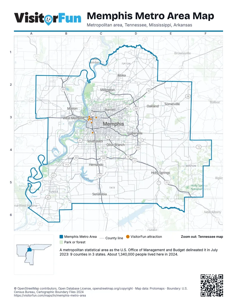
Highway index of Memphis Metro Area
Each highway on the sheet and the grid squares it crosses.
- I-22D4, D5, E5, F5
- I-40A3, B3, C3, D2, D3, E2
- I-55B2, B3, C3, C4, C5, C6
- I-69B4, C4
- I-240C3
- I-269C4, D3, D4
- I-555B2
- US 51C2, C3, D1, D2
- US 61A6, B4, B5, C3, C4
- US 64A2, B2, B3, C3, D3, E2, E3
- US 70C3
- US 72D4, E4, F4
- US 78B2, B3, C3, C4, D4, D5, E5, F5
- US 79C3
- MS 4B5, E5
- MS 7E5, E6
- TN 59D1
- TN 175C4
- MS 302C4, D4
- MS 304B4, C4, D4
- TN 385C2, C3, D2, D3, D4
- MS 713B4
Things to do on the Memphis Metro Area map
- Art Museum of the University of Memphis
- Bass Pro Shops at the Pyramid
- Beale Street
- Belz Museum of Asian and Judaic Art
- Blues Hall of Fame
- Children's Museum of Memphis
- Edge Motor Museum
- Fire Museum of Memphis
- Graceland
- Meeman-Shelby Forest State Park
- Memphis Brooks Museum of Art
- Memphis Rock 'n' Soul Museum
- Memphis Zoo
- Metal Museum
- National Civil Rights Museum
- Pink Palace Museum and Planetarium
- Stax Museum of American Soul Music
- Sun Studio
- The Cotton Museum
- The Peabody Memphis
Places on the map
- Atoka
- Bartlett
- Collierville
- Hernando
- Holly Springs
- Marion
- Memphis
- Millington
- Oakland
- Olive Branch
- Senatobia
- Somerville
- Southaven
- West Memphis
© OpenStreetMap contributors, Open Database License, openstreetmap.org/copyright · Map data: Protomaps · Boundary: U.S. Census Bureau, Cartographic Boundary Files 2024