

Texas map
El Paso map
About 681,723 people live here (Census Bureau, 2024 estimate). The sheet's index lists 151 streets; Dyer Street, Gateway North Boulevard and Gateway South Boulevard cross the most grid squares. Things to do inside the boundary: Mission Del Rey and The Outlet Shoppes at El Paso.
Open the map (PDF, US Letter)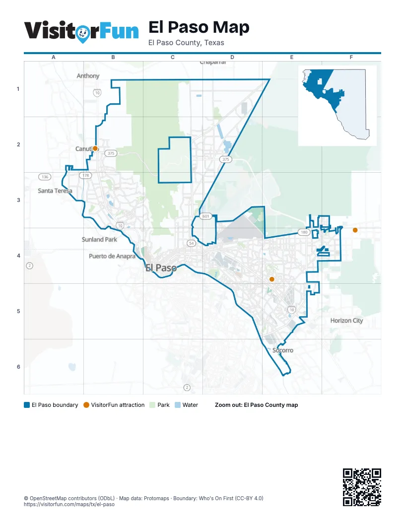
Street index of El Paso
Each street on the sheet and the grid squares it crosses.
- Martin Luther King Jr BoulevardC1, C2
- Stan Roberts Sr AvenueC1, D1
- Dyer StreetD1, E1, D2, C3, D3, C4
- Gateway North BoulevardD1, E1, C2, D2, C3, C4
- Gateway South BoulevardD1, E1, C2, D2, C3, C4
- McCombs DriveD1
- McCombs StreetD1, D2
- Edge of Texas StreetE1
- Artcraft RoadB2, A3, B3
- Camino Real de Tierra AdentroB2, B3, B4
- Doniphan DriveB2, B3, B4
- Loop 375B2
- North Desert BoulevardB2, B3, B4
- North Resler DriveB2, B3
- Northern Pass DriveB2, B3
- Paseo del NorteB2
- Paseo Del Norte DriveB2
- Plexxar DriveB2
- South Desert BoulevardB2, B3, B4
- Spur 16B2
- Talbot AvenueB2
- Woodrow Bean Transmountain DriveB2, C2, D2, C3
- Diana DriveC2, C3, D3
- Kenworthy StreetC2
- Patriot FreewayC2, C3, C4
- Borderland ExpresswayD2
- Gateway Boulevard SouthD2
- Purple Heart Memorial FreewayD2
- Railroad DriveD2, C3, D3
- Sean Haggerty DriveD2
- Country Club RoadA3, B3
- East Redd RoadB3
- North Mesa StreetB3, C3, C4
- Redd RoadB3
- Shadow Mountain DriveB3
- South Resler DriveB3
- Sunland Park DriveB3, B4
- Thorn AvenueB3
- Westwind DriveB3
- Alabama StreetC3, C4
- Cassidy RoadC3
- Fred Wilson AvenueC3
- Fred Wilson RoadC3, D3
- Hondo Pass AvenueC3
- Hondo Pass DriveC3, D3
- Liberty ExpresswayC3, D3
- Magnetic DriveC3
- Magnetic StreetC3
- Marshall RoadC3
- Monroe AvenueC3
- Van Buren AvenueC3
- Airport RoadD3, D4
- Global Reach DriveD3, D4, E4
- Montana AvenueF3, C4, D4, E4
- North Zaragoza RoadF3, E4, F4, E5
- Border West ExpresswayB4, C4
- Executive Center BoulevardB4, C4
- McNutt RoadB4
- West Paisano DriveB4, C4
- Alameda AvenueC4, D4, D5, E5
- Arizona AvenueC4
- César Chávez Border HighwayC4, D4, D5, E5
- Coles StreetC4
- Copia StreetC4
- Customs DriveC4
- Delta DriveC4, D4
- Detroit AvenueC4
- Douglas AvenueC4
- East 6th AvenueC4
- East 7th AvenueC4
- East Franklin AvenueC4
- East Missouri AvenueC4
- East Paisano DriveC4, D4
- East Rio Grande AvenueC4
- East San Antonio AvenueC4
- East Schuster AvenueC4
- East Yandell DriveC4
- Fort BoulevardC4
- Gateway Boulevard EastC4, D4, E4, E5
- Gateway Boulevard WestC4, D4, E4, E5
- Grant AvenueC4
- Linea de CamionesC4
- Magnolia StreetC4
- Memphis AvenueC4
- Montecillo BoulevardC4
- Murchison DriveC4
- North Campbell StreetC4
- North Copia StreetC4
- North Cotton StreetC4
- North Dallas StreetC4
- North Eucalyptus StreetC4
- North Kansas StreetC4
- North Piedras StreetC4
- North Raynor StreetC4
- North Santa Fe StreetC4
- Pershing DriveC4
- Puente Internacional Cordova de las AmericasC4
- South Campbell StreetC4
- South Cotton StreetC4
- South El Paso StreetC4
- South Kansas StreetC4
- South Mesa StreetC4
- South Piedras StreetC4
- South Santa Fe StreetC4
- South Stanton StreetC4
- Spur 1966C4
- Texas AvenueC4
- Tompkins RoadC4
- Trowbridge DriveC4, D4
- West Schuster AvenueC4
- West Wyoming AvenueC4
- West Yandell DriveC4
- Wyoming AvenueC4
- Airport DriveD4
- Airway BoulevardD4
- Edgemere BoulevardD4, E4, F4
- El Dorado DriveD4
- Fonseca DriveD4
- Geronimo DriveD4
- Hawkins BoulevardD4
- Hunter DriveD4
- McRae BoulevardD4
- Montwood DriveD4, E4
- North Carolina DriveD4, D5
- North Clark DriveD4
- North Loop DriveD4, D5, E5
- North Yarbrough DriveD4, E4, D5
- Pebble Hills BoulevardD4, E4, F4
- Viscount BoulevardD4
- Vista del Sol DriveD4, E4, E5
- Arturo Benavides Memorial FreewayE4
- George Dieter DriveE4, E5
- Joe Battle BoulevardE4, E5
- Lomaland DriveE4, D5, E5
- North Lee Trevino DriveE4, E5
- Pellicano DriveE4, E5
- Rich Beem BoulevardE4, F4
- Rojas DriveE4, E5
- Saul Kleinfeld DriveE4
- John Hayes StreetF4
- Midway DriveD5
- Padres DriveD5
- Puente Internacional Zaragoza WaterfillD5
- South Yarbrough DriveD5
- South Zaragoza RoadD5, E5
- Yarbrough DriveD5
- Zaragoza Truck BridgeD5
- North Americas AvenueE5
- Paseo del Este BoulevardE5
- Socorro RoadE5, E6
- South Americas AvenueE5
Things to do on the El Paso map
Places on the map
- Album Park Path
- Americas
- Americas High School
- Angel's Triangle
- Apollo Heights East
- Apollo Heights West
- Argonaut Heights
- Arlington Park
- Ascarate Golf Course
- Ascarate Lake
- Ascarate Park
- Avalon West
- Billy Rogers Arroyo
- Blackie Chesher Park
- Borderland Heights
- Bowie High School
- Bradley
- Butterfield Trail Golf Club
- Campo del Sol
- Castner Heights
- Cielo Vista Apartments
- Cielo Vista Mall
- Cimarron Sage
- Cimarron Sky
- Cohen Entertainment District
- Cooperstown
- Copper Power Plant
- Coronado Country Golf Course
- Coronado Shopping Center
- Coronado Townhomes
- Del Valle High School
- Del Valle Middle School
- Desert Basin
- Desert Sands
- Desert Springs
- Eastside Regional Park
- Eastview
- Edgemere Linear Park
- El Dorado Estates
- El Paseo Marketplace
Next to El Paso
- Anthony
- Canutillo
- Chaparral
- Horizon City
- Puerto de Anapra
- Santa Teresa
- Socorro
- Sunland Park
© OpenStreetMap contributors (ODbL) · Map data: Protomaps · Boundary: Who's On First (CC-BY 4.0)