

Texas map
Grapevine map
About 51,320 people live here (Census Bureau, 2024 estimate). The sheet's index lists 300 streets; ARFF Road, International Parkway and Ira E. Woods Avenue cross the most grid squares. Things to do inside the boundary: Legoland Discovery Center Dallas Fort Worth, Grapevine Mills and Sea Life Grapevine.
Open the map (PDF, US Letter)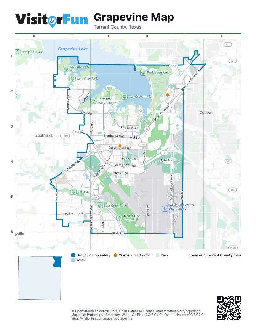
Street index of Grapevine
Each street on the sheet and the grid squares it crosses.
- International ParkwayE3, E4, E5, E6
- SH 114 TEXpressC4, D4, E4
- Grapevine Mills ParkwayE1, E2
- West John W. Carpenter FreewayD4, E4
- Lyndon B. Johnson FreewayE3
- Ira E. Woods AvenueB4, C4, A5, B5
- State Highway 26D2, E2, D3, C4
- North State Highway 121E1, F1, E2, E3
- Texan TrailD3, D4
- Grapevine Mills TrailE2
- William D Tate AvenueC4, B5, C5, C6
- Mustang DriveB4, C4, D4
- North Airfield DriveD4, E4
- Dove Loop RoadC2, C3, D3
- State Highway 360C5, C6
- Hall Johnson RoadB5, C5, B6, C6
- West State Highway 114B3, C3, C4
- Heritage AvenueB4, B5, B6
- South Service RoadE4, E5, E6
- North Service RoadE4, E5, E6
- Dove RoadB2, B3, C3
- East State Highway 114B3, C4, D4
- Glade RoadC6, D6
- South Main StreetC3, C4
- Pool RoadB4, B5, B6
- East Dallas RoadC4, D4
- Grapevine Mills Boulevard NorthE2
- Stone Myers ParkwayC4, C5
- West Northwest HighwayB3, C3
- Park BoulevardC3
- Bass Pro DriveD3, E3
- Lakeside ParkwayD1, E1
- Ruth Wall RoadD3
- East Northwest HighwayC3, D3
- Freeport ParkwayE1
- Ball StreetC3, C4
- North Kimball AvenueB2, B3
- West Dallas RoadC4
- West Bethel RoadE3
- State Highway 121C4
- North Park BoulevardC3
- North Main StreetC3, C6
- South Park BoulevardC3
- Crossunder #5E6
- Crossunder #2E5
- West Sandy Lake RoadE2
- South Kimball AvenueB4
- Brumlow AvenueB4
- East Glade RoadC6
- East Dove RoadB2
- West Airfield-Braniff DriveD5, D6
- Fairway DriveD1, D2, D3
- West Airfield DriveD4, D5, D6
- Silvercrest LaneB2, B3
- Terminal AE5
- Gaylord TrailD3
- Terminal EE6
- Euless Grapevine RoadC5, C6
- Terminal BE5
- Terminal DE5
- Terminal CE5
- Timberline DriveB4, B5
- Kubota DriveE2
- Oak Grove Loop SouthC2, C3
- West Wall StreetC3
- Grapevine Mills Circle EastE2
- Baze RoadC6
- West College StreetC4
- North Dooley StreetC3, D3
- North Dove RoadC3
- Minters Chapel RoadD4
- Hughes RoadC6
- West Kimball AvenueB2, C2
- Oak Grove Loop NorthC2
- Grapevine Mills Circle WestD2, E2
- Hanover DriveC4, D4
- East Wall StreetC3, D3
- West 21st StreetD5
- Westport ParkwayC5
- Champagne BoulevardC6
- 17th StreetC4, D4, D5
- Turner RoadC3, D3
- Grayson DriveB4, C4, B5, C5
- Vine StreetC4
- Boyd DriveD3
- Stars and Stripes WayE2
- Wildwood DriveC3, D3
- South Dooley StreetC3, C4
- Great Wolf DriveD3
- Esters BoulevardE3, E4
- Crossunder 3E5
- Municipal WayC4
- Regent BoulevardE3
- Banyan DriveC3
- Capitol StreetC4, D4
- Trade Center DriveE1
- Nolen DriveB4
- Southwest Grapevine ParkwayB4, C4
- Ruth Wall StreetD3
- Crossunder #1E4
- Enterprise DriveE1
- Prospect WayC5
- East Nash StreetC4
- 11th StreetC4
- Patriot DriveE1
- Pony ParkwayC3
- South Dove RoadC3
- Grapevine Mills Boulevard SouthE2
- Gateway BoulevardC6
- East Highland StreetB3
- Wall StreetC3
- South 20th AvenueE6
- ARFF RoadD4, E4, C5, D5, E5, D6, E6
- ARRF RoadC5, D5, D6
- Meadowmere LaneB1, B2
- Lakeview DriveB2, C2
- Katies Woods DriveC2, D2, C3, D3
- Industrial BoulevardC3, B4, C4
- North Employee RoadD4, E4, D5, E5
- Mockingbird DriveC2
- Foxfire LaneB2
- Tanglewood DriveB4, B5
- Snakey LaneB2
- Sunfish DriveD2, D3
- Lakeridge DriveB2, C2
- Barberry RoadB5
- East Texas StreetC3, D3
- W T Parr RoadB5
- East Worth StreetC3, D3
- Oak Creek DriveB4, B5
- North Lucas DriveC3
- Grapevine TrailC2, C3, D3
- Bellaire DriveC4
- West Hudgins StreetC4
- Yellowstone DriveC3
- Big Bucks DriveE3
- Haydenbend CircleC6
- Old Mill RunB5
- Peninsula DriveB2
- Pinehurst DriveB2
- Bushong RoadC3, D3
- Panhandle DriveB2, B3
- Kimberly DriveB2
- Darren G Medlin TrailC2
- Red Bird LaneB2
- Meadow DriveB5, B6
- Laguna Vista WayC2
- Daltons DriveD1, D2
- Sonnet DriveC2, C3
- Anderson Gibson RoadD2, E2
- Wintergreen TerraceB5
- Shady Brook DriveC3
- 27th StreetD6
- Trinity ParkwayD4
- Parkwood DriveB4, B5
- Roberts RoadB5, B6
- Altacrest DriveC6
- South Pine StreetC4
- Park Road 4B1
- Red Bud DriveD3
- Cable Creek DriveC3, D3
- 19th StreetD5
- Creekview DriveB5
- Perch Lane WestB1
- Cimarron TrailC2, B3
- Shadow Glen DriveC6
- Willowood DriveB4, B5
- Silverside DriveD2, D3
- Murrell RoadC2, C3
- Stoneway DriveC2
- DFW Airport Vehicle Service RoadE6
- Winding Creek Drive WestB3
- Western Oaks DriveB5, C5
- Mercury DriveB2
- Chapparal DriveB4
- Fall CreekC3
- Limerick LaneC2
- Austin StreetD3, D4
- Woodbriar DriveB3
- Wedgewood DriveB4, B5
- Drexel DriveC3, C4
- Forest Hills RoadB2, C2
- Hidden Lake DriveB2
- Hood LaneC2, C3
- Church StreetC3, C4
- Easy StreetD4
- Heatherdale DriveC6
- Birch AvenueB6
- Outlet DriveD2
- Metro CircleC4, D4
- Brookside DriveC3
- North Scribner StreetC3
- Dove Creek CircleC3
- Hummingbird TrailC2
- High DriveB2
- Spring Creek DriveC3
- Woodland Hills DriveB5
- Summerfield DriveB6
- Vintage DriveC3
- Knob Oak DriveB6
- Terrace DriveC4
- Port America PlaceD4
- Meadowbrook DriveC3
- Ponderosa TrailB4
- Bear Run DriveC5, C6
- Treatment TrailD2, D3
- Water Oak DriveC3
- Hilltop DriveC3, C6
- Springhill DriveB5
- Vineyard Creek DriveC6
- Hampton RoadC3
- Hallmont DriveB5, B6
- West Nash StreetC4
- Boxwood DriveB5
- East Franklin StreetC3, D3
- Trail Lake DriveB2
- Enchanted WayE2, E3
- Perch Lane EastB1
- Sweet Briar StreetB2
- Columbine DriveB5
- Marina DriveD2, D3
- East 16th StreetE4
- Hightimber DriveB5
- Overlook DriveC3
- Lancaster DriveC4
- Dublin CircleC3
- Bass Pro CourtD3
- Casa Loma CourtC2
- Sprindeltree DriveB6
- Berkley DriveC4
- Coppell RoadD3
- Trevor TrailC6
- Ernest Dean ParkwayC4
- Airline DriveC4
- Marsh LaneB5
- Timber Hill DriveB5
- Mesa Verde TrailB3
- Valleywood DriveB6
- Oak Forest DriveB5
- Ruth StreetD3, D4
- Brettenmeadow DriveC6
- Countryside DriveB6
- Riverwalk DriveE1
- Camelot DriveB2, B3
- North Support RoadE6
- Soccer RoadC2
- Horseshoe DriveB5
- Brookgate DriveB3, C3
- HoneysuckleC3
- Midway DriveB1
- North 24th AvenueE4, E5
- South Barton StreetC3
- Windswept LaneC5, C6
- Bass Pro EntrywayE2, E3
- Merlot AvenueC6
- Rolling Hills LaneB5
- Parr LaneB5
- Southridge DriveB5
- South Riverside DriveC3, D3
- Twelve Oaks LaneB5
- Canyon DriveB5
- Wentwood DriveB5
- North Riverside DriveD3
- Thistlewood LaneC2
- Cresthaven DriveB4
- Westgate PlazaB3
- Domain DriveC2, C3
- Heatherwood DriveD3
- OverlandB4
- Woodhaven DriveB2
- Sand Bass DriveC2, D2
- Stonecrest DriveB5
- Highland DriveB5
- Longhorn TrailB2
- Jenkins StreetC3
- East Hudgins StreetC4
- Metroplace DriveC4
- South Ball StreetC4
- McPherson DriveB3, C3
- Cripple Creek TrailB3
- Kelsey CourtB5
- Log Cabin LaneB4
- Chisholm TrailB4
- Pavilion PlaceD1
- Chris Craft DriveD2, D3
- Harbor AvenueC3
- East College StreetC4
- North Creekwood DriveB5
- Lone Star LaneB2
- Boathouse DriveC2
- Mapleridge DriveB6
- Brentcove DriveB3, C3
- High Countryside DriveB5
- Baylor ParkwayC4
- Corporate DriveE1
- West Port DriveC5
- River Oaks DriveB5
- Country LaneC6
- Post Oak RoadC6
- Roaring Springs RoadB2
Things to do on the Grapevine map
Places on the map
- 1E Corporate Aviation Ramp
- American Airlines Hangar 3
- American Airlines Hangar 4
- Bass Pro Shops
- Bear Creek Park
- Chicken N Pickle
- Cowboys Golf Club and Grapevine Golf Course
- Cross Timbers Middle School
- Dallas/Fort Worth International Airport
- Embassy Suites by Hilton
- Express North - Covered
- Express North - Uncovered
- Grapevine High School
- Grapevine Mills
- Grapevine Mills Mall
- Grapevine Towne Center
- Horseshoe Trails Park
- Lake View Park
- McPherson Slough
- Meadowmere Park
- NW Hold Pad
- Oak Grove Park
- Parr Park
- Remote North
- Rockledge Park
- SW Hold Pad
- Terminal A
- Terminal B
- Terminal C
- Terminal D
- Terminal E
- Texas Health Surgical Specialists
- Trail at Elan Grapevine
- UPS - DFW Air Gateway
- UPS Ramp
- Wall-Farrar Park
- West Air Freight
Next to Grapevine
© OpenStreetMap contributors, Open Database License, openstreetmap.org/copyright · Map data: Protomaps · Boundary: Who's On First (CC-BY 4.0); Quattroshapes (CC BY 2.0)















