

Texas map
Lubbock map
About 272,086 people live here (Census Bureau, 2024 estimate). The sheet's index lists 195 streets; Marsha Sharp Freeway, Marshall Formby Memorial Highway and 4th Street cross the most grid squares. Things to do inside the boundary: American Windmill Museum.
Open the map (PDF, US Letter)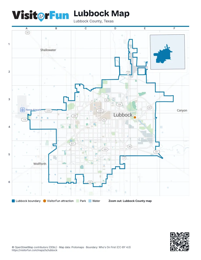
Street index of Lubbock
Each street on the sheet and the grid squares it crosses.
- Keuka StreetD1
- North Interstate 27D1, D2, D3
- Clovis RoadC2, C3, D3
- North County Road 1900C2
- North Frankford AvenueC2, C3
- North Slide RoadC2, C3
- Bluefield StreetD2
- East Regis StreetD2, E2
- Marshall Formby Memorial HighwayD2, D3, D4, D5
- North University AvenueD2, D3
- Regis StreetD2
- East FM 2641E2
- East Kent StreetE2
- North Martin Luther King Jr. BoulevardE2, E3
- 4th StreetA3, B3, C3, D3
- County Road 1700B3
- County Road 6500B3
- Erskine StreetB3, C3, D3
- Milwaukee AvenueB3, B4, B5, B6
- North Milwaukee AvenueB3
- Upland AvenueB3, B4, B5, B6
- 1st PlaceC3
- Auburn DriveC3
- Auburn StreetC3
- Chicago AvenueC3, C4, C5, C6
- Colgate StreetC3
- Elkhart AvenueC3
- Emory StreetC3
- Frankford AvenueC3, C4, C5, C6
- Landmark LaneC3, D3
- Loop 289C3
- North Chicago AvenueC3
- North Elkhart AvenueC3
- North Loop 289C3, D3
- North Memphis AvenueC3
- North Quaker AvenueC3
- North Texas Tech ParkwayC3
- North Utica AvenueC3
- North Winston AvenueC3
- Quaker AvenueC3, C4, C5, C6
- Slide RoadC3, C4, C5, C6
- Texas Tech ParkwayC3, C4, D4
- Toledo AvenueC3, C4
- West Loop 289C3, C4, C5
- 6th StreetD3
- Avenue AD3, D4, D5
- Avenue KD3, D4
- Avenue LD3, D4
- Avenue OD3, D4
- Avenue PD3, D4, D5
- Avenue QD3, D4
- Avenue TD3, D4
- Avenue UD3, D4, D5
- Avenue XD3, D4
- Buddy Holly AvenueD3, D4
- Cesar E. Chavez DriveD3, E3, E4
- Detroit AvenueD3, D5
- East Municipal DriveD3, E3
- Flint AvenueD3, D4, D5
- Glenna Goodacre BoulevardD3, D4
- Indiana AvenueD3, D4, D5, D6
- Interstate 27D3, D4, D5
- Lubbock Business Park BoulevardD3, E3
- Mac Davis LaneD3
- Marsha Sharp FreewayD3, E3, B4, C4, D4, B5
- Marshall StreetD3
- Municipal DriveD3
- North Ash AvenueD3
- North Avenue ND3
- North Avenue PD3
- North Avenue QD3
- North Avenue Q DriveD3
- North Avenue UD3
- North Detroit AvenueD3
- North Flint AvenueD3
- North Gary AvenueD3
- North Indiana AvenueD3
- Northeast Loop 289D3, E3
- Texas AvenueD3, D4
- University AvenueD3, D4, D5, D6
- Yucca LaneD3
- East 4th StreetE3
- East 5th StreetE3
- East Erskine StreetE3
- East FM 40E3
- East Loop 289E3, E4, E5
- Guava AvenueE3, E4
- Idalou RoadE3, F3, E4
- Martin Luther King Jr. BoulevardE3, E4, E5
- North Guava AvenueE3
- North Redwood AvenueE3
- North Zenith AvenueE3
- Parkway DriveE3
- Zenith AvenueE3, E4
- 19th StreetA4, B4, C4, D4
- 34th StreetA4, B4, C4, D4
- FM 179A4
- Highway 114A4
- Inler AvenueA4
- Reasearch BoulevardA4
- 26th StreetB4, C4, D4
- 29th StreetB4, C4
- 43rd StreetB4, C4
- 50th StreetB4, C4, D4
- Iola AvenueB4, B5
- 10th StreetC4, D4
- 13th StreetC4, D4
- 24th StreetC4, D4
- 29th DriveC4
- 41st StreetC4
- 42nd StreetC4, D4
- 54th StreetC4, D4
- Brownfield DriveC4
- City Bank ParkwayC4
- Englewood AvenueC4
- Memphis AvenueC4, C5, C6
- Salem AvenueC4
- Utica AvenueC4, C5
- 32nd StreetD4
- 40th StreetD4
- Avenue ED4
- Avenue MD4
- Avenue Q South DriveD4, D5
- Avenue RD4
- Avenue SD4
- Boston AvenueD4, D5
- BroadwayD4
- East 19th StreetD4, E4
- East 34th StreetD4, E4
- East 50th StreetD4, E4
- East BroadwayD4, E4
- Elgin AvenueD4, D5
- Main StreetD4
- Canyon Lake DriveE4
- Elm AvenueE4, E5
- Southeast DriveE4, E5, F5
- Spruce AvenueE4
- Vanda AvenueE4
- 66th StreetB5, C5, D5
- 73rd StreetB5, C5
- 79th StreetB5, C5
- 82nd StreetB5, C5, D5
- 92nd StreetB5, C5
- 93rd StreetB5, C5
- 98th StreetB5, C5, D5
- Alcove AvenueB5
- County Road 7200B5
- Marsha Sharp Freeway Frontage RoadB5
- Pontiac AvenueB5
- Quincy AvenueB5
- Spur 327B5, C5
- 57th StreetC5
- 58th StreetC5, D5
- 64th StreetC5
- 69th StreetC5
- 74th StreetC5, D5
- 86th DriveC5, D5
- 86th StreetC5, D5
- 87th StreetC5
- 90th StreetC5, D5
- 91st StreetC5, D5
- 93rd DriveC5
- 94th StreetC5, D5
- 95th StreetC5
- Joliet DriveC5, D5
- Knoxville AvenueC5
- Knoxville DriveC5
- Memphis DriveC5
- Peoria AvenueC5
- South Loop 289C5, D5
- Vicksburg AvenueC5
- 70th StreetD5
- 78th StreetD5
- 88th DriveD5
- 88th StreetD5
- County Road 2300D5
- East 66th StreetD5, E5
- East 82nd StreetD5, E5
- Geneva AvenueD5
- Hartford AvenueD5
- Hartford DriveD5
- Slaton RoadD5, E5, F5
- Southeast Loop 289D5, E5
- Tahoka HighwayD5
- East 74th StreetE5
- FM 3431E5
- Olive AvenueE5
- Peach AvenueE5
- FM 3020F5
- 114th StreetB6, C6, D6
- 130th StreetB6, C6, D6
- County Road 1800C6
- FM 1730C6
- Lubbock Outer RouteC6, D6
- South Loop 88C6, D6
Things to do on the Lubbock map
Places on the map
- 19west
- 21 Hundred at Overton Park
- Abbey Glen
- Adventure Park
- Affordable Self Storage
- Affordable Storage
- Alderson Middle School
- Alex "Ty" Cooke Station
- Alford Terrace
- All Saints Episcopal School
- Amazon LBB5
- American Wind Power Center
- Apex Villas Lubbock
- Arnett Benson
- Arts District
- Ashton Pointe Apartments
- Atkins Middle School
- Attenbury Grain
- Aura Modern Living
- Aztlan Park
- Bacon Crest
- Ballenger
- Bayer Museum of Agriculture
- Bayless-Atkins
- Beck Steel
- Bella Villas
- Belmont Ridge Apartments
- Bender Terrace
- Bent Tree
- Bentwood Apartments
- Bingo Express
- Boulders at Lakeridge
- Bowie
- Branchwater Apartments
- Brentwood
- Brickstone Villas Apartments
- Briercroft Center
- Briercroft Office Park
- Brooke Heights
- Buddy Holly Recreation Area
Next to Lubbock
- Canyon
- Shallowater
- Wolfforth
© OpenStreetMap contributors (ODbL) · Map data: Protomaps · Boundary: Who's On First (CC-BY 4.0)