

Texas map
Stafford map
About 17,555 people live here (Census Bureau, 2024 estimate). The sheet's index lists 296 streets; West Airport Boulevard, Murphy Road and Southwest Freeway cross the most grid squares. Also on it: Atrium Medical Center, Brand Lane Islamic Center and City of Stafford City Hall.
Open the map (PDF, US Letter)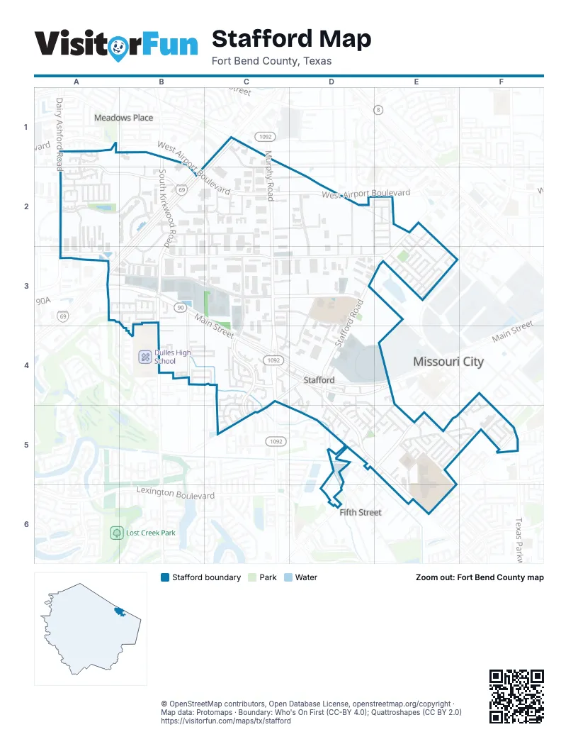
Street index of Stafford
Each street on the sheet and the grid squares it crosses.
- Aspen LaneA1
- Dairy Ashford RoadA1, A2
- Emerald LeafA1, A2
- Grapevine CourtA1
- Grove Stone CourtA1
- Grove West BoulevardA1, A2
- Maple Leaf LaneA1
- Orchard CourtA1
- Snowbird CourtA1
- Sundance CourtA1
- Tanglewood CourtA1
- West Airport BoulevardA1, B2, C2, D2
- South Kirkwood RoadB1, B2, B3
- Sugardale DriveB1, B2
- Altonbury LaneC1
- Brighton LaneC1
- Murphy RoadC1, C2, C3, C4
- Nations BoulevardC1, C2
- Southwest FreewayC1, B2, A3, B3
- Southwest Freeway Frontage RoadC1, B2, A3, B3
- US 59 (Southwest Freeway) HOV/HOT laneC1
- Ariel CourtA2
- Ashley Grove CourtA2
- Audubon CourtA2
- Breezy Meadow DriveA2
- Cardinal Meadow DriveA2
- Directors DriveA2, A3
- Doe MeadowA2
- Elk MeadowA2
- Enclave CourtA2
- Exchange DriveA2, A3
- ExecutiveA2
- Executive DriveA2, A3
- Fern Meadow DriveA2
- Fountain Lake DriveA2, B2
- Fox MeadowA2
- Glenmeadow DriveA2
- Green Trails DriveA2
- Grove Meadow DriveA2
- Jersey Meadow DriveA2
- Julie Rivers DriveA2
- Laurel CourtA2
- Meadow Briar DriveA2
- Meadow Gate DriveA2
- Meadow Ridge DriveA2
- Mullholand DriveA2
- Oyster Cove CourtA2
- Pine Brook DriveA2
- Robin MeadowA2
- Southmeadow DriveA2
- Sugar Grove BoulevardA2, B2
- Sweetwater CourtA2
- Bluebonnet DriveB2, C2
- Century DriveB2, B3
- Fountain Lake CircleB2
- Kirkwood DriveB2, F5
- Laser ShotB2, C2
- Lebon LaneB2
- Network DriveB2, C2
- Nexus AvenueB2, C2
- Royal DriveB2, B3
- Techniplex DriveB2, B3
- Volt LaneB2
- Capricorn StreetC2, C3
- Circuit laneC2
- Fountaingate DriveC2, D2
- Parc Crest DriveC2
- Spectrum LaneC2
- Trinity DriveC2, C3
- Windsor LaneC2, D2
- Bates LaneD2, D3
- Flaxseed WayD2, E2, E3
- Jebbia DriveD2
- Jebbia LaneD2, D3
- Lyrical DriveD2, E2
- Mula CircleD2
- Mula LaneD2, D3
- Oldcrest DriveD2, E2
- Sugar Ridge BoulevardD2, D3
- Betty LaneE2, E3
- Cravens RoadE2, E3
- Cymbal DriveE2
- Folkcrest WayE2, E3
- Folklore WayE2
- Folknoll DriveE2
- Frank LaneE2, E3
- Lawrence LaneE2, E3
- Linda StreetE2, E3
- Mackworth DriveE2
- Riceville School RoadE2
- Rose Ann StreetE2, E3
- Stafford RoadE2, D3, E3, D4
- Youngcrest DriveE2
- Buckingham PlaceA3
- Chesterfield LaneA3, B3
- Corporate DriveA3
- Country Club BoulevardA3, B3
- Foxbriar LaneA3
- Main StreetA3, B3, C3, C4
- Wright RoadA3, B3
- Aberdeen StreetB3
- Alpine RoadB3
- Amesbury CourtB3
- Brand LaneB3, B4
- Brocket PlaceB3
- Buena Vista StreetB3
- Cash RoadB3, C3, D3
- Dulles AvenueB3, B4
- East Sutton SquareB3
- Essex PlaceB3
- Greenbriar DriveB3, C3
- Longview RoadB3
- North Sutton SquareB3
- Oak StreetB3
- Pinery DriveB3
- South Sutton SquareB3
- West Sutton SquareB3
- Whitehall PlaceB3
- Briarside DriveC3, C4
- Dublin CourtC3
- Mula RoadC3, D3, E3
- North Promenade BoulevardC3
- Promenade BoulevardC3, C4, C5
- Scarpinato RoadC3, D3
- Stafford Centre DriveC3, D3, D4
- Emily LaneD3
- Greenland DriveD3, D4
- Mula CourtD3
- Pike RoadD3, E3
- Redfish LaneD3
- Stafford Point DriveD3, D4
- Straus CourtD3
- Antonia StreetE3
- Bonnie LaneE3
- Frances StreetE3
- Francis LaneE3
- Gina StreetE3
- James LaneE3
- Joan StreetE3
- Josephine StreetE3
- Kitty StreetE3
- Lindsey LaneE3
- Louise StreetE3
- Mark StreetE3
- Naples CircleE3
- Naples CourtE3
- Naples LaneE3
- Stafford Colony LaneE3
- Suzanne StreetE3
- Taylor LaneE3
- Tyler CourtE3
- Tyler LaneE3
- Venice CircleE3
- Venice LaneE3
- Angela StreetB4
- Castle LaneB4
- Crescent LaneB4
- Drive BB4, C4
- Drive DB4
- Edenborn DriveB4
- Esther StreetB4
- Ethel LaneB4, C4
- Ferro StreetB4, C4
- Ludwig LaneB4, C4
- Maurice WayB4, C4
- Nina LaneB4
- Perez StreetB4
- Annes WayC4
- Avenue AC4
- Avenue BC4, D4
- Avenue EC4, D4, C5
- Boardwalk ParkwayC4
- Carlie WayC4
- Carriage LaneC4, D5
- Corridor PlaceC4
- Corridor WayC4, C5
- Drive AC4
- Elana LaneC4
- Esplanade PlaceC4
- Esplanade WayC4
- Greenbough DriveC4, D4
- HavensC4
- Jay's LaneC4, C5
- Katy StreetC4, D4
- Leisure LaneC4, C5
- North Esplanade WayC4
- North Main StreetC4, D4, E4
- Regal Ranch RoadC4
- Sandy WalkC4, C5
- Saunter DriveC4
- South Esplanade LaneC4
- South Esplanade WayC4
- South Main StreetC4, D4, E4
- Strolling WayC4
- Wheelhouse CourtC4
- Wheelhouse DriveC4
- Willard's WayC4, C5
- Avenue CD4
- Avenue DD4
- Avenue FD4
- Avenue HD4
- Avenue ID4
- Ellis StreetD4
- Eppolito StreetD4, D5
- Kings WayD4, D5
- Knights CircleD4, D5
- Park Hill LaneD4
- Plantation LaneD4
- Squires BendD4, E5
- Stafford Run RoadD4, D5
- Staffordshire RoadD4, D5, E5, E6
- West Park HillD4, D5
- Willow DriveD4, D5
- Thompson CircleE4
- Zenobie StreetE4
- Adams StreetF4, E5, F5
- Crestmont DriveF4, F5
- Hackberry StreetF4, F5
- Pecan LaneF4, F5
- Texas ParkwayF4, F5
- Childers CourtC5
- Gregory CourtC5
- Marathon PlaceC5
- North Marathon WayC5
- Robins WayC5
- Shady Brook DriveC5
- Shady Dale DriveC5
- South Marathon WayC5
- 1st StreetD5, E5
- 5th StreetD5, E5, D6
- Castle PlaceD5
- Cedar Brook CourtD5
- Crest CourtD5
- Duchess WayD5
- Elm View CourtD5
- Fair Oak CourtD5
- Fair Oak DriveD5
- Jester LaneD5
- Juniper CourtD5
- Kings CourtD5
- Lance LaneD5
- Live Oak DriveD5
- Maple Tree CourtD5
- Moore RoadD5
- Palace DriveD5
- Queens CourtD5, E5
- Queens CutD5
- 6th StreetE5
- Akj StreetE5
- Beverly CircleE5
- Bold Ruler DriveE5
- Canonero StreetE5
- Carl CourtE5
- Center StreetE5
- Citation DriveE5
- Constitution AvenueE5, E6
- Dukes BendE5
- Easy Jet DriveE5
- Gallant Fox DriveE5
- Go-Man-Go DriveE5
- Kelso CourtE5
- Nashua DriveE5
- Overland StreetE5, F5
- Present StreetE5
- Randall StreetE5
- Reva RidgeE5
- Robinwood DriveE5, F5
- Ruffian LaneE5
- Secretariet DriveE5
- Silver StreetE5
- Stafford Pride DriveE5
- Swords BendE5
- Terence DriveE5, F5
- War Admiral DriveE5
- West Bend DriveE5
- West StreetE5
- Westwood DriveE5, F5
- Whirlaway DriveE5
- Arcott AvenueF5
- Arcott LaneF5
- Carol Lynn DriveF5
- Golf CourtF5
- Harvey StreetF5
- Mimosa RoadF5
- Nikki LaneF5
- Scanlin RoadF5, E6
- Shirleen DriveF5
- Terrence CourtF5
- Wesley DriveF5
- Columbia Blue DriveE6
- Deborah StreetE6
- Elm Shadow DriveE6
- Rastus AvenueE6
- Red 'N' Gold DriveE6
- Ruth AvenueE6
- Spartan DriveE6
Places on the map
- AMC Fountains 18
- Amegy Bank
- Americas Best Value Inn & Suites - Stafford / Houston
- Applebee's
- Atrium Medical Center
- Avalon Diner
- Bombshells Restaurant & Bar
- Brand Lane Islamic Center
- Calvary Church at the Fountians
- Chevron
- Chick-fil-A
- Chipotle
- City of Stafford City Hall
- Comfort Suites
- Costco Business Center
- Courtyard Houston Sugar Land/Stafford
- Days Inn & Suites by Wyndham Sugarland/Stafford
- Destiny Events Venue
- El Tiempo Cantina
- Extended Stay America - Houston - Stafford
- First Street Park
- Frost Bank
- Fuddruckers
- Gordon Fountain Lake Park
- Hampton Inn Houston/Stafford
- Holiday Inn Express
- Home2 Suites Houston Stafford
- Homewood Suites by Hilton Houston Stafford Sugar Land
- Houston City College Southwest
- IHOP
- In-N-Out Burger
- Jack in the Box
- Jehovah's Witnesses Church
- Kim Son
- La Michoacana Meat Market
- La Quinta Inn & Suites Houston Stafford Sugarland
- Las Haciendas
- Puffer-Sweiven, LP
- Stafford Center
- Walmart Supercenter
Next to Stafford
- Crestmont Place
- Fifth Street
- Meadows Place
- Missouri City map
© OpenStreetMap contributors, Open Database License, openstreetmap.org/copyright · Map data: Protomaps · Boundary: Who's On First (CC-BY 4.0); Quattroshapes (CC BY 2.0)















