

Texas map
Waco map
About 146,608 people live here (Census Bureau, 2024 estimate). The sheet's index lists 300 streets; South Jack Kultgen Expressway, West Waco Drive and Lake Shore Drive cross the most grid squares. Things to do inside the boundary: Brazos Bluffs Ranch, Brazos Tours and Cameron Park Zoo.
Open the map (PDF, US Letter)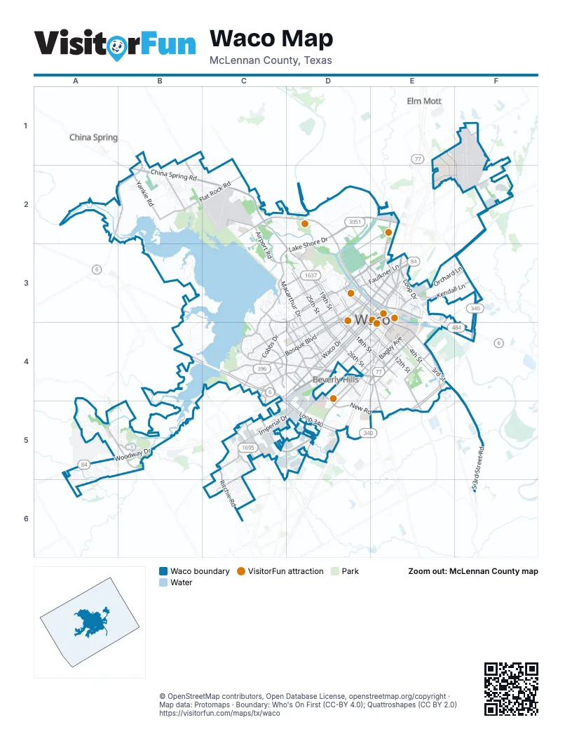
Street index of Waco
Each street on the sheet and the grid squares it crosses.
- South Jack Kultgen ExpresswayE3, D4, E4, D5
- Marlin HighwayE3, E4, F4
- North Jack Kultgen ExpresswayE3
- South Loop DriveE3, E4
- George W Bush ParkwayA5, B5
- Purple Heart TrailE3, D5
- West Waco DriveD3, E3, C4, D4
- Franklin AvenueE3, C4, D4
- Lake Shore DriveD2, C3, D3, C4
- Bosque BoulevardD3, C4, D4
- East Waco DriveE3
- La Salle AvenueD4, E4
- North 19th StreetC2, C3, D3, D4
- East Lake Shore DriveD2, E2
- East Loop 340F3, F4
- North Valley Mills DriveC4, D4
- North 18th StreetD3, D4
- North Loop DriveE3
- South Valley Mills DriveD4, E4
- South 18th StreetD4, E4
- Homan AvenueD3, D4
- North 17th StreetD3, D4
- East US Highway 84F2
- West US Highway 84A5
- South 17th StreetD4, E4
- North Hewitt DriveC5
- Robinson DriveE4, E5
- Industrial BoulevardE2
- North 18th A StreetD3
- New Dallas HighwayE3
- The CircleE4
- Valley Mills DriveD4
- South 18th Street CrossingE4
- China Spring RoadB2, C2
- West Loop 340C4, C5, D5
- Herring AvenueD3, E3
- South University Parks DriveE3, E4
- Bagby AvenueD4, E4, D5
- West State Highway 6C4
- Texas Central ParkwayC5, D5
- North Martin Luther King Jr BoulevardD3, E3
- South Loop 340E4, D5, E5
- North 25th StreetD3, D4
- Woodway DriveC4, A5, B5, C5
- South Martin Luther King Jr BoulevardE3
- North River CrossingA2, B2
- South 4th StreetE3, E4
- Lake Air DriveC3, C4, D4
- North 26th StreetD3, D4
- Dutton AvenueD4, E4
- Ritchie RoadC5, C6
- Washington AvenueD3, E3, D4
- South New RoadD4, D5, E5
- Cobbs DriveD3, C4, D4
- Imperial DriveC5, D5
- Gholson RoadE2, E3
- Chapel RoadC5
- North Highway 6B4, C4
- Hillcrest DriveC3, D3, C4
- Lyle AvenueC3, D3
- North 4th StreetD3, E3
- Macarthur DriveC3, D3
- South 26th StreetD4, E4
- North 5th StreetD3, E3
- Speegleville RoadA5, B5
- Garden DriveE4, E5
- North University Parks DriveD3, E3
- North 41st StreetC3, D3, D4
- North New RoadD4
- Old Lorena RoadB5
- Taylor StreetE3
- Elm AvenueE3
- Clifton StreetE3
- Exchange ParkwayD5
- Forrest StreetE3
- Martin Luther King Jr BoulevardD2, D3
- Garrison StreetE3
- Crest DriveE1
- Memorial DriveD4
- East Crest DriveE1
- Elk Road SpurF3
- North Old Temple RoadD5
- North Interstate 35E3
- South 2nd Street CrossingE3
- South Interstate 35D5
- Franklin CrossoverD4
- Elm StreetE3
- Bellmead DriveE3
- Sanger AvenueC4, D4
- Steinbeck Bend DriveC2, D2
- South 3rd StreetE3, E4, F4
- Colcord AvenueD3, D4
- South 3rd Street RoadF4, F5, F6
- Flat Rock RoadB2, C2
- Austin AvenueE3, D4
- Speight AvenueD4, E4, D5
- Orchard LaneE3, F3
- J J Flewellen RoadD2, E2, D3, E3
- Clay AvenueE3, D4, E4
- Wooded Acres DriveC4
- Kendall LaneE3, F3
- Maple AvenueD3, D4
- South 12th StreetD4, E4
- Yankie RoadB2
- Faulkner LaneD3, E3
- Tree Lake DriveB2
- South 11th StreetD4, E4
- Panther WayC5, C6
- Airline DriveE1, F1, F2
- Airport RoadC2, C3
- North 34th StreetD3, D4
- Dallas StreetD3, E3
- Primrose DriveD4, E4
- South 8th StreetD3, E3, E4
- Park Lake DriveC3, D3
- North 12th StreetD3, D4
- Old Hewitt RoadC5
- South 5th StreetE3, E4
- South 12th Street RoadE4, E5
- Fish Pond RoadC4
- McFerrin AvenueD3
- North 39th StreetD4
- North 38th StreetD4
- Bishop DriveC4
- North 11th StreetD3, D4
- Karl May DriveC2
- Turner StreetD3, E3
- North 36th StreetD3, D4
- Old McGregor RoadC4, C5
- Concord RoadF2
- Twin Rivers CircleB5
- Richland DriveC4
- East Craven AvenueE2, F2
- Air Base RoadE2
- Cherry StreetE3
- Richter AvenueD4
- Mazanec RoadE1, F1
- Campus DriveE1, E2
- Wortham Bend RoadB1, B2
- McLaughlin RoadB3, C3
- North Old Robinson RoadE5
- Old Robinson RoadE4, E5
- West Warren StreetC6
- Woodgate DriveC5
- Circle RoadE4
- Beverly DriveD5
- North Industrial DriveD4
- Hillsboro DriveE3
- Chappel Hill RoadE3, F3, E4
- North 65th StreetC4
- College DriveD3
- Industrial DriveD4, D5
- East Garden DriveE4
- Londonderry DriveC4, C5
- Owen LaneC4
- Irving Lee StreetD4
- New Sanger RoadC4
- Old China Spring RoadB1, B2
- Sunset StreetD4
- Towne Oaks DriveD4
- Village Center BoulevardA5, B5
- Central Park DriveC5
- Elk RoadF3
- Montrose StreetE2
- Twin Rivers BoulevardB5
- Mall DriveC4
- Estates DriveC4
- Pioneer ParkwayC2
- Spur 1637B2
- South 38th StreetD4
- East Tinsley RoadF4
- Delhi RoadC4
- Meyers LaneF2
- Over Flow RoadB3, C3, B4, C4
- North 27th StreetD3, D4
- North 23rd StreetD3, D4
- North 22nd StreetD3, D4
- North 20th StreetD3, D4
- North 30th StreetD3, D4
- North 21st StreetD3, D4
- North 24th StreetD3, D4
- North 31st StreetC3, D3, D4
- Daughtrey AvenueD4, E4
- Trice AvenueD3, C4, D4
- Pine AvenueD3, C4, D4
- Morrow AvenueD3, D4
- Cumberland AvenueD3, D4
- North 28th StreetD3, D4
- Fort AvenueD4
- North 29th StreetD3, D4
- Skeet Eason RoadB2, C2
- North 32nd StreetD3, D4
- North 16th StreetD3, D4
- South 16th StreetD4, E4
- Cameron Park DriveD3
- Old Steinbeck RoadD2
- Liveoak AvenueD3, C4, D4
- Windsor AvenueD3, D4
- South 9th StreetD3, D4, E4
- James AvenueD4, E4
- North 15th StreetD3, D4
- Gurley LaneE4
- Columbus AvenueD3, E3, D4
- Webster AvenueE3, D4, E4
- Proctor AvenueD3, C4
- Ethel AvenueD3, D4
- Baylor AvenueD4, E4
- Reynolds Creek LoopB3
- Old Marlin RoadE3, F4
- Gorman AvenueD4
- South 10th StreetE4
- North 6th StreetD3, E3
- Parrott AvenueD3, D4
- San Ann RoadB3, B4
- Colonial AvenueC4, D4
- North 42nd StreetC3, C4, D4
- Mitchell AvenueD3
- North 15th A StreetD3
- Alexander AvenueD3
- McKenzie AvenueC3, D3
- South 2nd StreetE3, E4
- Classic DriveB3
- Mary AvenueE3, D4, E4
- Summer AvenueD3
- North 43rd StreetC3, C4, D4
- Airport ParkB2, C2, C3
- South 15th StreetD4, E4
- South 7th StreetE3, E4
- Lasker AvenueD3, D4
- Aviation ParkwayF2
- North 33rd StreetD3, D4
- Ross AvenueE3, D4, E4
- Reuter AvenueD3
- Wood AvenueD4, E4, D5
- Gurley AvenueD4, E4
- Mars DriveC5
- Ridgewood DriveC4
- Cleveland AvenueD4, E4
- South 19th StreetD4, E4
- Connor AvenueD4, E4
- Edmond AvenueC4, D4
- Sherman StreetD3, E3
- Marketplace DriveD5
- North 13th StreetD3, D4
- Preston StreetD3, E3
- Grim AvenueD4
- Avenue BE1, C2, E2
- Tennyson DriveC4, D4
- North 35th StreetD3, D4
- Hood StreetD3, E3
- South 22nd StreetD4, E4
- North 37th StreetD4
- Edna AvenueD3
- Burnett AvenueD4, E4
- Meadow Mountain DriveC5
- Stewart DriveC3, D3
- North 10th StreetD3
- South 24th StreetD4, E4
- Logue LaneC2, D2
- Rambler DriveC4
- South 20th StreetD4, E4
- Spring StreetE3
- Columbia StreetD4, D5
- Cole AvenueD4
- North Speegleville RoadB3
- South 21st StreetD4, E4
- North 9th StreetD3
- Flint AvenueD4, E4
- Mountainview DriveC4
- Highlander DriveD3
- Stageline DriveA5, B5
- Salem WayB2, C2
- North 7th StreetD3, E3
- North 44th StreetC4, D4
- Park AvenueD4, E4
- Jefferson AvenueD3, E3, D4
- Arnett LaneB2
- La Porte DriveC4
- South 27th StreetD4, E4
- Rolando AvenueD4
- South 23rd StreetD4, E4
- Huaco LaneD4
- Brannon DriveC3
- Erath AvenueC4, D4
- Jonquil DriveB2
- Independence TrailB2
- Selby LaneF2
- Chestnut StreetE3
- Joy DriveC2, D2
- Polo Park DriveC5, C6
- Jewell DriveC5
- South 13th StreetD4, E4
- Oak Creek CircleA5
- Meridian AvenueD3
- Gary LaneC2
- Canyon TrailA5
- Gateway DriveD5
- Chimney Hill DriveC3, D3
- Lariat TrailA5
- South 14th StreetD4, E4
Things to do on the Waco map
Places on the map
- Airport Park
- Ascension Providence
- Baylor Basin
- Baylor University
- Bear Ridge Golf Course
- Bledsoe-Miller Park
- Brazos Park East
- Cameron Park
- Cameron Park Zoo
- Camp Fimfo Waco
- Central Texas MarketPlace
- Cottonwood Creek Golf Course
- Doris Miller Circle
- Doris Miller VA Medical Center
- Flying J Travel Center
- Franklin Village Shopping Center
- Indian Spring Middle School
- La Vega Junior High School
- Lake Waco
- Lake Waco Golf Club
- M. Lipsitz and Company LTD
- Midway High School
- Oakwood Cemetery
- Oceans Behavioral Hospital Of Waco
- Old Speegleville
- Reynolds Creek Loop
- Richland Mall
- Ridgewood Country Club
- River Valley Middle School
- Rosemound Cemetery
- Speegleville Park
- Texas State Technical College
- The Waco Centre
- Twin Rivers Circle
- University High School
- Waco Center for Youth
- Waco Commons
- Waco Creek
- Waco Skeet and Trap Club
- Woodway Activity Park
Next to Waco
- Beverly Hills
- China Spring
- Elm Mott
© OpenStreetMap contributors, Open Database License, openstreetmap.org/copyright · Map data: Protomaps · Boundary: Who's On First (CC-BY 4.0); Quattroshapes (CC BY 2.0)