

Utah map
Bountiful map
About 45,024 people live here (Census Bureau, 2024 estimate). The sheet's index lists 300 streets; Bountiful Boulevard, 400 East and 200 West cross the most grid squares. Also on it: Bountiful Ridge Golf Course, Lakeview Hospital and Renaissance Towne Center.
Open the map (PDF, US Letter)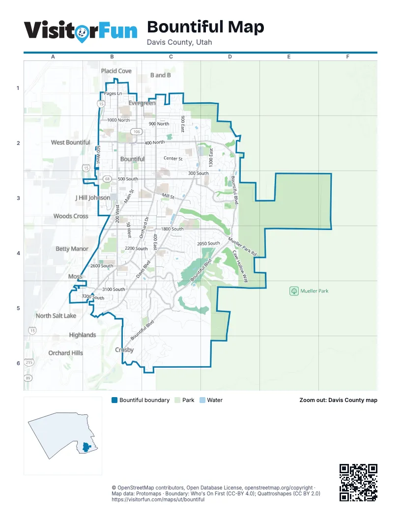
Street index of Bountiful
Each street on the sheet and the grid squares it crosses.
- Veterans Memorial HighwayB1, B3
- 500 WestB2, B3, B4, B5
- 500 SouthB3, C3
- Highway 89A4, A5
- Bountiful BoulevardD2, D3, C4, D4, B5, C5, B6
- 200 WestB1, B2, B3, B4, B5
- 400 EastC1, C2, C3, C4, A5, C5
- Main StreetB1, B2, B3, B4
- Orchard DriveC3, B4, C4, B5
- 400 NorthB2, C2, D2
- 1800 SouthB4, C4, D4
- 300 WestB1, B2, B3, B4, B5
- 400 WestB1, B2, B3, B4, B5
- Mueller Park RoadD4
- 2600 SouthB4, C4
- Eaglewood DriveB5
- North 200 WestB1
- Eagleridge DriveB6
- Davis BoulevardC2, C3, B4, C4, B5
- 200 EastC1, C2, C3, C4, C5
- 1500 SouthB3, C3
- 100 WestB1, B2, B3, B4, B5
- 3100 SouthA5, B5, C5
- Lakeview DriveC3, D3
- Mill StreetC3
- Pages LaneB1
- 1000 NorthB2, C2
- Chelsea DriveC4, C5
- Indian Springs RoadC5
- North Canyon RoadB4, C4
- 2150 SouthC4
- 1100 SouthB3, C3
- Frontage RoadB1
- 800 WestA5
- 1875 SouthB4, C4
- Center StreetB2, C2, D2
- 100 EastB2, B3, B4, B5, C5
- 800 EastC2, C3, C4
- 300 SouthB2, B3, C3, D3
- 900 EastC1, C2, C4, C5
- Hidden Lake DriveB6, C6
- 350 WestB1, B2, B3, B4, B5
- 650 EastC1, C2, C3, C4, C5
- Millbrook WayC3, D3, D4
- 200 NorthB2, C2
- 1300 EastD2, D3, D4
- 1700 SouthB3, B4, C4, D4
- 900 NorthB2, C2
- 1050 NorthB2, C2
- 750 EastC2, C3, C4
- 50 WestB3, B4, B5
- 250 NorthB2, C2, D2
- 600 EastC1, C2, C3
- 2050 SouthB4, C4, D4
- Summerwood DriveC5, B6, C6
- 100 NorthB2, C2
- 100 SouthB2, C2
- Oakwood DriveC4, C5
- 200 SouthB2, C2, D2
- Maple Hills DriveD4
- 300 EastC2, C3, C4
- 3300 SouthA5, B5, C5
- 550 NorthB2, C2
- Monarch DriveB5, B6
- Moss Hill DriveD2, D3
- 300 NorthB2, C2, D2
- 1000 EastC2, C3
- Cave Hollow WayD4, D5
- 2200 SouthB4, C4
- 1200 NorthB1, C1
- Canyon Creek DriveC5, D5
- Ridge Point DriveD3, D4
- 1400 NorthB1, C1
- 850 EastC1, C2, C3, C4
- Sunset Hollow DriveC5
- 1350 NorthB1, C1
- 1400 SouthB3, C3
- 3400 SouthA5, B5
- Skyline DriveD2
- 400 SouthB3, C3, D3
- Wood Hollow WayD4, D5
- 1600 SouthB3, C3
- 1650 SouthB3, C3, D3
- Northridge DriveD2
- 700 EastC1, C2, C4
- 3000 SouthB5, C5
- Highland Oaks DriveC5
- 1200 SouthB3, C3, D3
- 1900 SouthB4, C4, D4
- 1150 EastD2, C3, C4, D4
- 3200 SouthA5, B5
- 500 EastC2, C3, C4
- 150 EastB4, C4, B5, C5
- 450 EastC1, C2, C4
- 800 SouthB3, C3
- Eagle Ridge DriveD2
- East Hills DriveC1
- 1200 EastD2, D3, D4
- Ridgewood WayD4
- 950 EastC1, C2, C5
- Elaine DriveC4
- Canyon Crest DriveD3
- 2900 SouthB4
- Claremont DriveC4
- 650 NorthB2, C2
- 700 NorthB2, C2, D2
- Stone Hollow DriveD3, D4
- Beverly WayC4, D4
- Ridge Hill DriveD4, E4
- Vineyard DriveD2
- Penman LaneB4
- 1450 NorthB1, C1
- 800 NorthB2, C2
- 250 SouthB2, C2, D2
- 3500 SouthB5
- 1950 SouthB4, C4
- Stone Ridge DriveD3, D4
- 425 WestB2, B3
- Windsor LaneC5
- 150 WestB1, B3, B4
- Edgehill DriveC4
- 1000 SouthB3, C3
- Mountain Oaks DriveC5, D5
- Huntington DriveC5
- 250 WestB1, B2, B4, B5
- 75 EastB3, B4, B5
- Wicker LaneB4
- Temple View DriveD3
- 1130 NorthC1, C2
- Pages Place DriveB1
- Canyon Estates DriveC5
- Bountiful Hills DriveC3, D3
- Medical DriveC2, C3
- Hidden Hollow DriveC6
- Ridge Hollow DriveD4
- Bonneville DriveB5, C5
- 1300 NorthB1, C1
- 2700 SouthB4
- Arlington WayC4
- 625 WestB4, B5
- Oakridge DriveB5, C5
- Bountiful Ridge DriveB6
- 325 WestB2, B5
- Maple Ridge DriveD4
- 1850 SouthC4, D4
- Gun Range RoadD1, D2
- 350 NorthC2
- Woodland Hills DriveC3
- Bonneview DriveC4
- Choke Cherry DriveD4
- Lorien DriveD3
- Bridlewood DriveB5
- Peach LaneC3
- 450 WestB3, B4, B5
- Brentwood LaneD3
- 2350 SouthB4
- High Pointe DriveD4
- East Pages LaneC1
- Spring Creek DriveC4
- 1500 EastD3
- 550 EastC1, C2, C4
- 750 NorthB2, C2
- 1225 EastD2, D3
- Madera Hills DriveD3
- 1175 EastC3, D3, D4
- 900 SouthB3
- 1050 SouthB3
- Northern Hills DriveC2, D2
- San Simeon WayC4
- Emerald Hills DriveC3, C4
- 1300 SouthB3
- Pheasant WayC4
- 2300 SouthB4, C4
- 1100 EastC2, C3
- Foothill DriveB5, B6
- Ward Canyon RoadD2
- 2400 SouthB4
- Sunset Loop RoadC5
- Glade Hollow WayB5, C5
- Oakridge LaneC3, D3
- 75 SouthC2, D2
- Mill Creek WayC3
- Renaissance Towne DriveB3, B4
- Orchard PlaceB4
- Woodmoor DriveC3, D3
- Summerview RoadB6, C6
- 1500 NorthB1, C1
- Ridgewood LaneD4
- Ridgeview DriveC2, C3
- Browns Park DriveD4
- 600 NorthB2, C2, D2
- Devon DriveC4, C5
- 175 WestB1, B3
- 2450 SouthB4, C4
- 325 SouthB3
- Boulton WayB4
- Millstream WayC3
- Oxford WayC6
- 2800 SouthB4
- Jeri DriveC4
- Briggs DriveC2, D2
- Bluebell DriveD4
- Lewis Park DriveC4
- 500 NorthC2, D2
- Green Oaks DriveC4
- Heritage DriveB5
- 2750 SouthB4, C4
- Viewcrest DriveD2
- 325 EastC1, C3
- 470 NorthB2, C2
- Maple Hollow WayD4, E4
- Barton Creek LaneD3
- Cove LaneD4
- 2100 SouthB4, C4
- Sunset DriveC3
- 775 EastC4
- Sterling DriveB5
- 775 NorthC2
- Country Springs DriveB1
- Oakview LaneD3
- 2000 SouthC4
- 550 WestB5
- Maple Grove WayD4
- Fairway DriveC4
- Charlene WayC3
- Lexington DriveC5
- Fair Oaks DriveC4
- 600 SouthB3, C3
- Maple Cove LaneD4, D5
- Granada DriveD2
- Maple View DriveD4
- 975 EastC5
- Indian Trail RoadD3
- Country Springs CircleB1
- Chapel DriveB2
- 1350 SouthB3
- 475 WestB5
- Carolyn WayC4
- Summer Meadow DriveC6
- 250 EastC1, C4
- 525 WestB5
- Timothy WayC4
- 350 EastC4
- 850 SouthB3
- 50 NorthD2
- Sunset WayB6
- 1550 NorthB1
- 650 WestB5
- 675 WestA5, B5
- 150 SouthB2, C2
- Park Shadows LaneB2
- 1825 SouthC4
- Eggett LaneD3
- 700 SouthC3
- Terrace DriveD3
- 725 EastC1, C2, B5
- Spring Meadow DriveC6
- 3550 SouthC5
- 1250 EastD2
- 50 EastB5
- Canyon Park RoadD3
- Country Springs LaneB1
- Deborah DriveC4
- Golf Course CircleD4
- 1125 EastC4
- 1250 NorthC1
- Hidden Lake Circle DriveC6
- 1375 EastD2
- Oakmont DriveC4
- Park Shadows CircleB2
- Concord WayC2
- 75 NorthC2
- Lewis Park CoveC4, C5
- Grand Oaks CircleD4
- Holbrook RoadB4
- Peregrine LaneB2
- 1050 EastC2, C3
- 1250 SouthB3
- Westwood RoadC3
- Crestwood CircleC1
- Jenkins LaneA5
- Summerview CircleC6
- Oakridge CircleC3, D3, B5
- Linden StreetB5
- Seville WayD2
- 2025 SouthC4
- Medford DriveB5, C5
- 2475 SouthD4
- 1100 NorthB1, C1
- 2500 SouthB4, C4
- 275 WestB2
- Lakecrest RoadD3
- Summer Meadow CircleC6
- Fremont RoadD3
- 740 SouthB3
- Applewood DriveB5
- Devonshire DriveB6
- 2550 SouthB4
- Crestview CircleB5
- Coronation WayB5
Places on the map
- 5th West Office Park
- Aaron's Auto Pro
- Appliance Discount Center
- Arby's
- Arvin's Flowers
- AutoZone
- Bank of Utah
- Big O Tires
- Boulton Elementary School
- Bountiful City Cemetery
- Bountiful City Park
- Bountiful Elementary School
- Bountiful High School
- Bountiful Junior High School
- Bountiful Lions Gun Range
- Bountiful Ridge Golf Course
- Bountiful Utah Temple
- Creekside Park
- Creekside Senior Living
- Davis County Library Bountiful Twig
- Fordham Commercial Park
- Holbrook Elementary School
- Lakeview Hospital
- Lewis Park
- Meadowbrook Elementary School
- Millcreek Junior High School
- Mueller Park Junior High
- Muir Elementary School
- North Canyon Park
- Oak Hills Elementary School
- Renaissance Towne Center
- South Davis Community Hospital
- South Davis Junior High School
- South Davis Recreation Center
- The Square at 2600 South
- The UPS Store
- Tolman Park
- Valley View Elementary School
- Viewmont High School
- Washington Park
Next to Bountiful
- A and K
- B and B
- Betty Manor
- Cahoon Acres
- Castle
- Centerville Acres
- Cobble Creek East
- Golden Meadows
- Green Meadows
- Highlands
- Hillside Gardens
- Hillside Oaks
- J Hill Johnson
- Major
- Manna Acres
- Meadow Crossing
- Miraleste
- Moss
- Nelhoca Place
- North Salt Lake map
- Oakleaf
- Orchard Hills
- Orchard Hills East
- Paul
- Pedersen
- Pitford Acres
- Placid Cove
- Randall Way
- Rivera Townhouses
- Sconberg
- Sheridan
- Spring Meadow
- Sundown
- Tanglewood Acres
- The Mills
- West Bountiful
- Westwood
- Williams West
- Wilson
- Woods Cross
© OpenStreetMap contributors, Open Database License, openstreetmap.org/copyright · Map data: Protomaps · Boundary: Who's On First (CC-BY 4.0); Quattroshapes (CC BY 2.0)















