

Vermont map
Chittenden County map
About 170,851 people live here (Census Bureau, 2024 estimate). The sheet's index lists 300 streets; River Road, North Road and Hinesburg Road cross the most grid squares. Things to do inside the boundary: Church Street Marketplace, ECHO Lake Aquarium and Science Center and ECHO, Leahy Center for Lake Champlain.
Open the map (PDF, US Letter)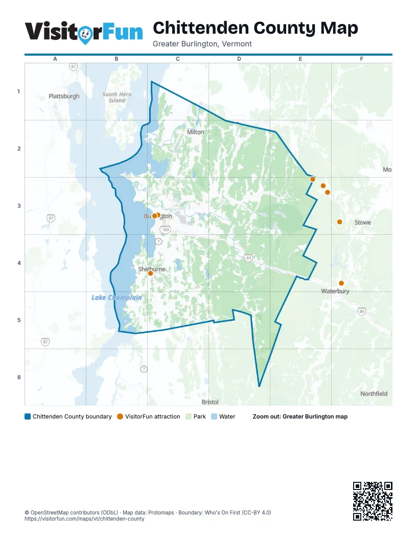
Street index of Chittenden County
Each street on the sheet and the grid squares it crosses.
- Spear StreetC3, C4, C5
- Hinesburg RoadC3, C4, D4, C5
- Vermont Route 15D2, E2, D3
- Vermont Route 116C4, C5, D5
- Shelburne RoadC3, C4
- Williston RoadC3, C4, D4
- River RoadB3, C3, D3, E3, D4, E4
- Main StreetC2, C3
- Roosevelt HighwayC2, C3
- Ethan Allen HighwayC1, C4, B5, C5
- U.S. Route 2B2, C2
- Theodore Roosevelt HighwayD4, E4
- Vermont Route 289C3, D3
- Jericho RoadD3, D4
- Pearl StreetC3
- Burlington BeltlineB3, C3
- U.S. Route 7 SouthC2
- Saint George RoadC3, C4
- East Main StreetD4
- Vermont Route 117D3, D4
- Essex RoadC3
- U.S. Route 7 NorthC1, C2
- West Main StreetD4
- Blakely RoadC3
- College ParkwayC3
- Maple StreetC3
- Vermont Route 2AC4
- Colchester RoadC3
- Champlain ParkwayC3
- West Lakeshore DriveB2, C2, C3
- River StreetC2, C3
- Park StreetC3, D3
- Riverside AvenueC3
- Prim RoadC2, B3, C3
- Shelburne StreetC3
- South Willard StreetC3
- Center RoadC3, D3
- East Allen StreetC3
- Upper Main StreetC3
- Colchester AvenueC3
- Susie Wilson RoadC3
- Heineberg DriveB3
- Lincoln StreetC3
- Manhattan DriveC3
- East AvenueC2, C3
- Susie Wilson BypassC3
- North Willard StreetC3
- Battery StreetC3
- North Champlain StreetC3
- Ethan Allen HomesteadC3
- U.S. Route 7C2
- South Channel Outlet BridgeB2
- Dorset StreetC3, C4, C5
- Browns River RoadD2, D3
- Browns TraceD3, D4
- North AvenueB3, C3
- Lime Kiln RoadC3, C4
- Shelburne Falls RoadC4
- Vermont Route 128D2
- Pine StreetC3
- Ferry RoadB5
- Vermont Route 17D6
- Kennedy DriveC3
- Severance RoadC3
- Irish Hill RoadC4
- Marshall AvenueC3
- Governor Peck RoadD4
- Airport ParkwayC3
- Falls RoadC4
- Saint Paul StreetC3
- South Union StreetC3
- Mill Brook RoadE3, D6
- Kimball AvenueC3
- Industrial AvenueC3
- Shelburne Hinesburg RoadC4
- South Winooski AvenueC3
- White StreetC3
- Governor Peck HighwayD4
- Airport DriveC3
- Flynn AvenueC3
- North Winooski AvenueC3
- Kellogg RoadC3
- Plattsburg AvenueB3
- Lakeside AvenueC1, C3
- North Union StreetC3
- Marsett RoadC4
- Sherman StreetC3
- Lake RoadC1, C2, B4, B5
- Old Stage RoadD2, C3, D3, D4
- Main RoadD4, D5, D6
- Mount Philo RoadC4, C5
- East RoadC2, C3
- Greenbush RoadB4, B5
- Pleasant Valley RoadE2, E3
- Middle RoadC2
- Oak Hill RoadC4, D4, C5
- Pond RoadC4, D4, D5
- North RoadC1, C2, D2, D4, D5
- Harbor RoadB4, C4
- Plains RoadD2, D3
- Bolton Valley Access RoadE4
- Huntington RoadD4
- West Milton RoadC2
- Duxbury RoadD4, E4
- Woods Hollow RoadD2
- Nashville RoadD3, E3, C4
- South Brownell RoadC3, C4
- Malletts Bay AvenueC3
- Ethan Allen RoadD3, E3
- Richmond RoadC4, D4
- Cochran RoadD4
- Silver StreetC5
- Everest RoadC1, C2
- Mountain View RoadC3, D3, D4
- Sand Hill RoadD2, D3, E3
- Bay RoadC2, B4, C4
- North Williston RoadD3, D4
- Cambridge RoadD2
- Westford RoadC2, D2
- Sanderson RoadC1, C2
- Hollow RoadD5
- Bear Trap RoadC2
- Thompson's Point RoadB5
- State Park RoadC5
- Charlotte RoadC5
- Barber Farm RoadD3
- Skunk Hollow RoadD3
- Brookside RoadD2
- Lee River RoadD3
- North StreetC2, C3
- Porters Point RoadB2, B3
- Bostwick RoadB4, C4
- Colchester Point RoadB2, B3
- Swift StreetC3, C4
- Old Creamery RoadC4
- Railroad StreetC2, C3, D4
- South Prospect StreetC3
- Westford-Milton RoadD2
- West StreetC3, E4
- Church Hill RoadB5, C5
- Mill Pond RoadC3
- South StreetC2, C3
- McMullen RoadC2
- Webster RoadC4
- East Lakeshore DriveC2, C3
- Hinesburg Hollow RoadD5
- Cheesefactory RoadC4
- Bridge StreetD4, D5
- Essex WayD3
- Patchen RoadC3
- Williams RoadC2, C3
- College StreetC3
- Queen City Park RoadC3
- Thomas RoadC4
- Holy Cross RoadB2, B3
- Pinecrest DriveC3
- Barstow RoadC4
- Grove StreetC3
- Barnes AvenueC3
- Allen Martin DriveD3
- Shunpike RoadC3
- Lafountain StreetC3
- Ethan Allen ParkwayB3
- Mechanicsville RoadC4, C5
- Church RoadB2, B3
- Allen RoadC4
- Allen Irish RoadD2, E2
- Barrett StreetC3
- Commerce StreetC3, C5
- Lavigne RoadC3, D3
- Farnsworth RoadC2
- Ledge RoadC2, D2, C3
- North Brownell RoadC3
- CVU RoadC4
- North Prospect StreetC3
- Farrell StreetC3
- Maple Tree LaneD2, C4
- Johnson AvenueC3
- Hobbs RoadC2
- Elmwood AvenueC3
- Home AvenueC3
- West Allen StreetC3
- Tyler Bridge RoadD5
- South Summit StreetC3
- East Spring StreetC3
- Dion StreetC3
- Bombardier RoadC2
- Gore RoadD6
- West Spring StreetC3
- Oak StreetC3
- Central StreetC3
- Spring StreetC3
- West Center StreetC3
- Railroad AvenueC3
- West Street ExtensionC3
- Tri Town RoadC4
- Toof RoadD2
- Irish Settlement RoadE2, E3
- Osgood Hill RoadD2, D3
- Poker Hill RoadD2, E2, D3
- Stage RoadE3, D4, E4
- Cilley Hill RoadD2, D3
- Notch RoadE4
- Texas Hill RoadD4, D5
- South RoadC3, C4, D4
- Chapin RoadD2, D3
- Lincoln Hill RoadD5
- Mountain RoadD2, E3
- Sherman Hollow RoadD4
- Baldwin RoadC5
- Poor Farm RoadC1, C2, C3, E3
- Beebe Hill RoadC1
- Brigham Hill RoadC2, D2, D3
- Guinea RoadC5
- Dugway RoadD4
- Wes White HillD4
- Lost Nation RoadC3
- Camel's Hump RoadD5, E5
- Lewis Creek RoadC5
- Rollin Irish RoadC2, D2
- Manley RoadC1, D2
- Snipe Ireland RoadD4
- Hillview RoadD4
- East StreetC3, E4, D5
- Governor Chittenden RoadD3, D4
- Gilman RoadC5
- Old Number Eleven RoadD2
- Stevensville RoadE3
- Upper English Settlement RoadD2, E2, D3, E3
- Robinson ParkwayC3
- Duffy RoadC2
- Prindle RoadC5
- Pettingill RoadD2
- Trapp RoadD5
- Huntley RoadD2
- Hibbard RoadC1
- Weed RoadD3, C4
- Bean RoadB3, C3, C5
- Orchard RoadC3, E3, B4, B5
- Sleepy Hollow RoadD3
- Kenyon RoadD4
- Covey RoadD2, E2
- East Hill RoadD4
- Mayo RoadC2, D4, D5
- Kd RoadD3, E3
- Cadreact RoadC1, C2
- Honey Hollow RoadE4
- North Gate RoadB4
- Butternut RoadC4
- Old Pump RoadD3, C4
- Hardscrabble RoadC2, D2
- Eagle Mountain Harbor RoadC1
- Murray AvenueC1
- Southview DriveC3, C4, D4
- Schillhammer RoadD3
- West Hill RoadD3
- Jasper Mine RoadC2
- Meadow LaneD3, C4, D4, E4
- Hanley LaneD3
- Tarbox RoadD3, D4
- Happy Hollow RoadD4
- Towers RoadD3
- Orr RoadD3
- Leavensworth RoadC4, C5
- Cold Spring RoadC1
- Marble Island RoadC2
- Carpenter RoadC4
- Packard RoadD3
- Fitzsimonds RoadD3
- National Guard AvenueC3
- Forest RoadC2, C3, D3, C4
- Brickyard RoadC2, C3
- Williams Hill RoadD4, C5
- Clay Point RoadC2
- Taft RoadD5
- Roscoe RoadC5
- Hayden Hill Road WestD5
- Braeloch RoadC2
- West Bolton RoadE3
- Grandview RoadC2
- Beartown RoadE3
- Quakers Smith Point RoadB4
- Range RoadE3
- Whalley RoadB5
- Northshore DriveB3
- Redmond RoadC3, D3
- Moody RoadD5
- Leary RoadE3, E4
- Pond Brook RoadC2, C4, D4
- Raceway RoadD3
- Fuller RoadC2, E2, E3
- Camp Kiniya RoadC2
- Johnnie Brook RoadD4
- Converse Bay RoadB5
- Bert White RoadD5
- Bishop RoadC4, D4
- Pheasant Hill RoadB4
- Cemetery RoadD3, E3, D4
- Old Farm RoadC3, D3, D4
- Figel Hill RoadE3
Things to do on the Chittenden County map
Places on the map
- Arrowhead Mountain Lake
- Bolton
- Bolton Valley
- Bolton Valley Resort
- Bombardier Park
- Buels Gore
- Burlington
- Burlington Air National Guard Base
- Burlington Country Club
- Camel's Hump Nordic Ski Area
- Camels Hump State Forest
- Camp Johnson
- Casavant Natural Area
- Causeway Park
- Cedar Knoll Country Club
- Centennial Woods Natural Area
- Champlain Valley Exposition
- Charlotte
- Colchester
- Colchester Bog Natural Area
- Colchester Pond
- Colchester Pond Natural Area
- Colchester Woods
- Delta Island
- Derway Island Natural Area
- Downtown
- Eagle Mountain Natural Area
- East Charlotte
- Essex
- Essex Country Club
- Essex Junction
- Ethan Allen Homestead
- Fred Johnson Wildlife Management Area
- Geprags Park
- Gillett Pond
- Hanksville
- Hannaford Plaza Retail Zone
- Hinesburg
- Huntington
- Huntington Center
Next to Chittenden County
- Bristol
- Northfield
- Plattsburgh
- Stowe
- Waterbury
© OpenStreetMap contributors, Open Database License, openstreetmap.org/copyright · Map data: Protomaps · Boundary: Who's On First (CC-BY 4.0); Quattroshapes (CC BY 2.0)