

Washington map
Chelan County map
About 81,228 people live here (Census Bureau, 2024 estimate). The sheet's index lists 300 streets; Washington Street, 1st Street and US 2 cross the most grid squares. Things to do inside the boundary: Apple Annie Antique Gallery, Cascade Loop and Cashmere Museum and Pioneer Village.
Open the map (PDF, US Letter)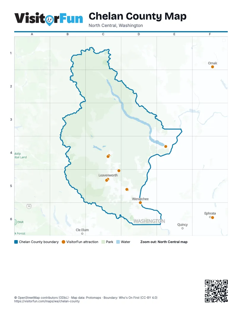
Street index of Chelan County
Each street on the sheet and the grid squares it crosses.
- US 97C5, C6
- US 2C4, C5, D5
- US Hwy 97AD5
- North Cascades HighwayC1
- Old Monitor RoadD5
- North Wenatchee AvenueD5, D6
- School StreetC5, D5
- South Wenatchee AvenueD6
- US Highway 97C5
- South Mission StreetD6
- West Woodin AvenueE4
- State Route 285D5, D6
- North Miller StreetD5, D6
- South Chelan AvenueD6
- North Mission StreetD5, D6
- North Chelan AvenueD5, D6
- East Woodin AvenueE4
- Euclid AvenueD5
- Odabashian BridgeD5
- West Webster AvenueE4
- State Highway 20C1
- Senator George Sellar BridgeD6
- Saunders StreetE4
- Webster AvenueE4
- Highway 20C1
- US2, US97D5
- Entiat River RoadD3, D4, D5
- South Lakeshore RoadD3, D4, E4
- Chumstick HighwayC4, C5
- Malaga-Alcoa HighwayD6, E6
- State Route 150D4, E4
- Navarre Coulee RoadD4
- Beaver Valley RoadC4
- Squilchuck RoadD6
- Easy StreetD5
- State Route 207C4
- Main StreetC5, D5, D6
- 5th StreetE4, D5
- North Western AvenueD5, D6
- South Miller StreetD6
- Maiden LaneD5
- Crawford AvenueD6
- Cherry StreetC5, D6
- Eels RoadD5
- West Manson HighwayE4
- South Columbia StreetD6
- Orondo AvenueD6
- Riverside DriveD5
- Chelan Falls RoadE4
- East Johnson AvenueE4
- Ferry StreetD6
- South Western AvenueD6
- South Worthen StreetD6
- North Worthen StreetD5, D6
- Cottage AvenueD5
- Marr StreetD6
- Russell StreetD6
- East Penny RoadD5
- Penny RoadD5
- Aplets WayD5
- North Saunders StreetE4
- Thurston StreetD6
- Washington AvenueE4
- Cotlets WayD5
- Chumstick RoadC5
- SR 150E4
- SR 150 "Y" Access HighwayE4
- Cotlet WayD5
- Chiwawa River RoadC3, C4
- Icicle RoadB5, C5
- Little Wenatchee River RoadB3, B4, C4
- Tyee Ridge RoadD4
- White River RoadB3, C3, C4
- Stemilt Loop RoadD6
- Chiwawa Loop RoadC4
- Colockum RoadD6, E6
- Mission Creek RoadD5
- Nahahum Canyon RoadD5
- Apple Acres RoadE3, E4
- Stemilt Creek RoadD6
- Lake Wenatchee HighwayC4
- Eagle Creek RoadC5
- River RoadC4
- Number 2 Canyon RoadD6
- Manson BoulevardD3, D4
- Mission Ridge RoadD6
- Washington StreetD3, D4, D5, D6
- Wapato Lake RoadD3, D4, E4
- Yaksum Canyon RoadD5
- North RoadC5, D5
- Green AvenueD3, D4
- Horse Lake RoadD5
- East Leavenworth RoadC5
- Methow StreetD6
- North Dryden RoadC5, D5
- Stine Hill RoadC5, D5
- Boyd RoadE4
- West Malaga RoadD6
- Boyd Loop RoadE4
- Cooper Gulch RoadE3, E4
- Red Apple RoadD5, D6
- Hay Canyon RoadD5
- Edgemont DriveD6
- Stemilt Hill RoadD6
- Pitcher Canyon RoadD6
- Sleepy Hollow RoadD5
- Maple StreetC5, D5
- 2nd StreetE4, C5, D5
- Totem Pole RoadD4
- Lower Sunnyslope RoadD5
- Wenatchee Heights RoadD6
- Mad River RoadD4
- Tigner RoadD5
- 1st StreetE4, C5, D5, D6
- Pioneer DriveD5, D6
- Okanogan AvenueD6
- North Bradley StreetE4
- Entiat WayD4, D5
- Fairview Canyon RoadD5
- Springwater AvenueD5
- Lower Chiwawa River RoadC4
- 9th StreetC5, D5
- Swartout RoadE4
- Number 1 Canyon RoadD5, D6
- Ski Hill DriveC5
- Sunset HighwayD5
- Willmorth DriveE4
- Titus RoadC5
- Castlerock AvenueD6
- Pine StreetD4, C5, D5
- Kittitas StreetD6
- Skyline DriveD5, D6
- Orchard AvenueD5, D6
- Hamlin RoadD6
- Ohme Garden RoadD5
- McKittrick StreetD5
- Kimber RoadD5
- Wapato WayD4
- Yakima StreetD5, D6
- Jim Smith RoadD6
- Pioneer AvenueD5
- Walnut StreetE4, D5
- Walla Walla AvenueD5
- Pioneer WayD5
- Steinbach RoadD6
- Millerdale AvenueD6
- North Columbia StreetE4, D5, D6
- Terminal AvenueD6
- Melody LaneD5
- Binder RoadD5
- Spokane StreetD6
- Palouse StreetD6
- Olive StreetD5
- Wye Connector RoadC4
- Birch StreetC5, D5
- Wescott DriveD5
- Olds Station RoadD5
- County Park RoadD5
- East Peters StreetD5
- West Peters StreetD5
- South Division StreetD5
- Goodwin RoadD5
- Appleland DriveD6
- Chatham Hill RoadD5
- Lambert StreetD6
- Technology Center WayD5
- Piere StreetD5
- East Gibson AvenueE4
- Evans StreetC5
- Front StreetC5
- North Navarre StreetE4
- Cordell StreetD5
- East Iowa StreetE4
- Hyland AvenueD4
- Chester Kimm RoadD5
- West Gibson AvenueE4
- South Sanders StreetE4
- East Hawley StreetD5
- Price AvenueC5
- Dryden AvenueC5
- Chehalis StreetD6
- Chatham Hill DriveD5
- East Farnham AvenueE4
- Burke AvenueC5
- Dawn TerraceD5
- East 9th StreetD5
- Sherbourne StreetC5
- Hawley StreetD5
- Shearson StreetD4, D5
- South Farnham StreetE4
- Hagen StreetD5
- East Gibson StreetE4
- Pearl Street SouthD6
- Grade Creek RoadD3
- Forest Road 5200C4, D4, D5
- Shady Pass RoadC3, D3
- Dinkelman Ridge RoadD4, D5
- Roaring Ridge RoadD4
- Derby Canyon RoadC5, D5
- Rainy Creek RoadB4
- Stehekin Valley RoadC1, C2
- National Forest Development Road 6930C4
- Railroad Creek RoadC2
- Mud Creek RoadD4
- Entiat Valley RoadC3, D3
- USFS 6601 RoadC4
- Big Meadow Creek RoadC4
- National Forest Development Road 5501D3, D4
- Tillicum RoadD4
- Washington Creek RoadE3
- Chikamin Ridge RoadC3
- Chelan Butte RoadE4
- Union Valley RoadE4
- Labyrinth Mountain RoadB4
- Forest Road 7415D5
- Tommy Creek RoadC3
- Burch Mountain RoadD5
- Potato Creek RoadD4
- Bear Mountain RoadD4, E4
- Merry Canyon RoadC4
- Scotty Creek RoadC6
- Old Blewett Pass HighwayC6
- Olalla Canyon RoadC5, D5
- Cooper Mountain RoadD3
- Downie Canyon RoadE4
- Pole Ridge RoadC4
- Forest Road 7520C4, D4, C5
- Mountain Home Ranch RoadC5
- Oklahoma Gulch RoadD4
- Forest Road 7401C5, D5
- National Forest Development Road 6910C4
- Forest Road 7500C5, D5
- Camp 12 RoadC4
- Swakane Canyon RoadD5
- Stayman Flats RoadD4, E4
- Camas Land RoadC5, C6
- Swanson Gulch RoadE3, E4
- Meadow Ridge RoadC4
- North Shore DriveC4, E4
- Sunitsch Canyon RoadC4
- Forest Road 5210-215D5
- Kingsbury RoadD6
- National Forest Service 5503D4
- Fish Lake RoadC4
- Liberty-Beehive RoadC6, D6
- Second Creek RoadC4
- Moses Carr RoadD6
- Packer Pole RoadC4
- South Fork Mud Creek RoadD4
- Joe Miller RoadD6
- Doc Bob Creek RoadC5
- Forest Road 6101C4
- Clark Canyon RoadC4
- North Fork Entiat RoadC3
- White Pine USFS 6950 RoadB4, C4
- Forest Road 7801C4
- East Van Creek RoadD4, D5
- Sears Creek RoadB3, C3, C4
- Ruby Creek RoadC5
- Eight Mile RoadC5
- West Chiwawa RoadC4
- Cedar Brae RoadC4
- Forest Road 6101-300C4
- Lakeshore DriveD4, D5
- Upper Wheeler RoadD6
- Mountain Home RoadC5
- Forest Road 6106C4
- Camas Creek RoadC5
- US Forest Service Road 6960B4
- Hawks Meadow RoadE4
- Antoine Creek RoadE3
- Five Mile RoadC6
- Jumpoff RoadD6
- Tarpiscan RoadE6
- Ivan Morse RoadE3, E4
- Gorge RoadE4
- North Derby RoadC5
- Cooper Ridge RoadE3
- Purtteman Gulch RoadE3, E4
- First Creek RoadD4
- Emerson Acres RoadD3
- East Fork Joe Creek USFS 8045 RoadE3
- Crum Canyon RoadD4
- Forest Road 6120C4
- Camas Saddle RoadC5, C6
- Stiss Canyon RoadD6
- Turk RoadE3, E4
- Cathedral Rock RoadD6
- Hatchery Creek RoadC4
- Walker Canyon RoadC5
- Dirty Face RoadC4
- Winesap AvenueE4
- Forest Road 7804C4
- Ingersoll RoadD6
- Bear Mountain Ranch RoadD4, E4
- Cagle Gulch RoadE4
- Forest Road 6100C4
- Jagla RoadD6
- Alder Creek RoadC4
- Tripp Canyon RoadC5, D5
Things to do on the Chelan County map
Places on the map
- Antilon Lake
- Apple Yard
- Bear Mountain Golf Course
- Beebe Springs Wildlife Area
- BLM
- Blue Creek Meadow
- Blue Glacier
- Buckner Glacier
- Butterfly Glacier
- Cache Glacier
- Camas Land
- Camas Meadows Natural Area Preserve
- Cashmere
- Cashmere Canyons Preserve
- Castle Rock Ridge
- Chain Lakes
- Chelan
- Chelan Butte Wildlife Area
- Chelan Coulees Preserve
- Chelan Falls
- Chelan PUD Homewater Preserve
- Chickamin Glacier
- Chiwaukum Lake
- Chiwawa Sno-Park
- Clark Glacier
- Colchuck Glacier
- Colchuck Lake
- Colchuck Permit Area
- Company Glacier
- Core Enchantments Permit Area
- Eightmile/Caroline Permit Area
- Entiat Wildlife Area
- Henry M. Jackson Wilderness
- Horse Lake Preserve (CDLT)
- Lake Chelan National Recreation Area
- Okanogan-Wenatchee National Forest
- Snow Permit Area
- Stuart Permit Area
- Swakane Wildlife Area
- White River Wildlife Area
Next to Chelan County
- Cle Elum
- Ephrata
- Omak
- Quincy
© OpenStreetMap contributors, Open Database License, openstreetmap.org/copyright · Map data: Protomaps · Boundary: Who's On First (CC-BY 4.0); Quattroshapes (CC BY 2.0)