

Washington map
Olympia map
About 56,271 people live here (Census Bureau, 2024 estimate). The sheet's index lists 300 streets; 14th Avenue Southeast, 18th Avenue Southeast and Union Avenue Southeast cross the most grid squares. Things to do inside the boundary: Capital Mall and Experience Olympia & Beyond Visitor Center.
Open the map (PDF, US Letter)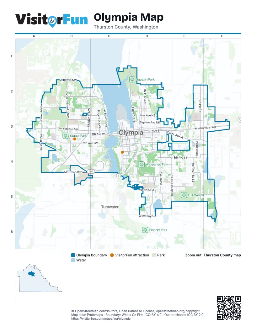
Street index of Olympia
Each street on the sheet and the grid squares it crosses.
- Harrison Avenue NorthwestA3, B3, C3
- Division Street NorthwestB2, B3
- Black Lake Boulevard SouthwestB3, A4, B4
- Martin Way EastE3, F3
- Pacific Avenue SoutheastD3, E3, F3
- 14th Avenue SoutheastC4, D4, E4, F4
- 4th Avenue EastC3, D3, E3
- 4th Avenue WestB3, C3
- State Avenue NortheastC3, D3, E3
- Capitol Way SouthC3, C4
- Capitol Way NorthC3
- Capitol Way SoutheastC3, C4
- Olympic Way NorthwestC3
- State Avenue NorthwestC3
- Water Street NorthwestC3
- College Street SoutheastF3
- 4th Avenue SouthC3
- Jim Moore Memorial ParkwayD4
- Henderson Boulevard SoutheastD4, D5, D6
- East Bay Drive NortheastD1, D2, D3
- Cooper Point Road SouthwestB3, B4, C4
- Cooper Point Road NorthwestB2, B3
- Plum Street SoutheastD3, D4
- Yelm Highway SoutheastD6
- Capitol Boulevard South EastC4, D4, D5
- Crosby Boulevard SouthwestC4
- Sleater Kinney Road SoutheastF3
- Boulevard Road SoutheastE3, E4, E5
- 18th Avenue SoutheastC4, D4, E4, F4
- Lilly Road NortheastE2, E3
- Deschutes Parkway SouthwestC3, C4
- West Bay Drive NorthwestC2, C3
- Morse-Merryman Road SoutheastE5
- 5th Avenue SoutheastC3, D3
- Legion Way SoutheastC3, D3
- 22nd Avenue SoutheastC4, D4, E4
- Bethel Street NortheastD2, D3
- Kaiser Road NorthwestA2, A3
- Eastside Street SoutheastD3, D4
- Central Street SoutheastD3, D4, D5
- Jefferson Street SoutheastC3, D3, D4
- Puget Street NortheastD2, D3
- 5th Avenue SouthwestB3, C3
- Olympia Avenue NortheastC3, D3, E3
- Central Street NortheastD2, D3
- Conger Avenue NorthwestB3, C3
- Union Avenue SoutheastD3, E3, C4, D4
- 8th Avenue SoutheastC3, D3, E3
- 11th Avenue SoutheastC4, D4
- 14th Avenue NorthwestA2, B2
- Rogers Street NorthwestC2, C3
- Capital Mall Drive SouthwestA3, B3
- Columbia Street SouthwestC3, C4
- McCormick Street SoutheastD3, D4, D5
- Eastside Street NortheastD2, D3
- Cain Road SoutheastD4, D5
- Hoffman Road SoutheastE4, E5
- 20th Avenue NorthwestA2, B2
- Wiggins Road SoutheastE4, E5
- 9th Avenue SouthwestA3, B3, C3
- Carlyon Avenue SoutheastD5
- Ensign Road NortheastE3, F3
- Log Cabin Road SoutheastD5, E5
- Wilson Street SoutheastD3, D4
- Sleater Kinney Road NortheastF2, F3
- Evergreen Park Drive SouthwestC4
- North Street SoutheastD5
- Decatur Street SouthwestC3, C4
- 26th Avenue NortheastD2, E2
- Franklin Street SoutheastC3, C4
- Eskridge Boulevard SoutheastD4
- San Francisco Avenue NortheastD2, D3
- Bowman Avenue NorthwestB3, C3
- Adams Street SoutheastC3, C4, D4
- Mottman Road SouthwestB4, C4
- 7th Avenue SouthwestA3, C3
- Fones Road SoutheastE3, E4
- Yauger Way NorthwestB3, B4
- Briggs Drive SoutheastD5, D6
- Walnut Road NorthwestB2
- Wheeler Avenue SoutheastD4
- 28th Avenue NorthwestB2
- Crestline Boulevard NorthwestC2
- Kaiser Road SouthwestA3
- Elliott Avenue NorthwestB2, C2
- Washington Street NortheastC3
- 21st Avenue SouthwestB4, C4
- Herman Road SoutheastE5, F5
- Maple Park Avenue SoutheastC4, D4
- Madison Avenue NorthwestB3, C3
- Columbia Street NorthwestC3
- Middle Street SoutheastD5
- 11th Avenue SouthwestB4, C4
- Yauger Way SouthwestB3
- Kenyon Street NorthwestB3
- Lilly Road SoutheastE3
- Evergreen Park Way SouthwestC4
- Bush Avenue NorthwestB3
- Lakeridge Drive SouthwestC4
- O Farrell Avenue SoutheastD4
- Galloway Street SoutheastD4
- 27th Avenue SoutheastC4, D4, E4
- 6th Avenue NortheastF3
- South Bay Road NortheastE3
- Irving Street SouthwestC4
- Pattison Street SoutheastE3
- R W Johnson Boulevard SouthwestB4
- Adams Street NortheastC3
- Somerset Hill Drive SouthwestB5
- Harbor View Road NorthwestC2
- Boston Harbor Road NortheastD1
- Legion Way SouthwestC3
- Elizabeth Street SoutheastE4
- Raft Avenue NorthwestC2
- Phoenix Street SoutheastE3
- Olympia Avenue NorthwestC3
- Overhulse Road NorthwestA3
- Union Avenue SouthwestC4
- Gull Harbor Road NortheastD2
- 15th Avenue NortheastF2
- Community College DriveC4
- Crites Street SouthwestB4
- Lakemoor Drive SouthwestA4, B4
- 7th Avenue SoutheastC3, D3, E3
- Thurston Avenue NortheastC3, D3, E3
- Fir Street SoutheastD3, D4, D5
- Quince Street NortheastD2, D3
- Goldcrest Drive NorthwestA2, B2
- Dr. Nels Hanson WayB4, B5
- Mall Loop DriveB3
- Thomas Street NorthwestC2, C3
- Marine Drive NortheastC2, C3, D3
- Washington Street SoutheastC3, C4
- Boundary Street SoutheastD3, D4, D5
- Bigelow Avenue NortheastD3, E3
- 9th Avenue SoutheastC3, D3, E3
- Tullis Street NortheastD2, D3
- 10th Avenue SoutheastC3, D3
- Prospect Avenue NortheastD3, E3
- Fir Street NortheastD2, D3
- Milroy Street NorthwestC2, C3
- Marion Street NortheastD2, D3
- Garrison Street NortheastD2, D3
- 28th Avenue SoutheastD4, E4
- Miller Avenue NortheastD2
- Quince Street SoutheastD3, D4, D5
- 6th Avenue SouthwestB3, C3
- Yew Avenue NortheastD3
- Pine Avenue NortheastD3
- Providence Street SoutheastE4, F4
- Fairview Street SoutheastD3, D4, D5
- 6th Avenue NorthwestA3, B3
- Frederick Street SoutheastD3, D4
- Ethridge Avenue NortheastD2
- Lybarger Street SoutheastD3, D4, D5
- Greenwood Drive SouthwestA3
- 12th Avenue SoutheastD4
- Water Street SouthwestC3, C4
- 12th Avenue SouthwestB4, C4
- Craig Road SoutheastE4
- Governor Stevens Avenue SoutheastD4, D5
- 13th Avenue SoutheastD4
- Jackson Avenue NorthwestB3, C3
- Garfield Avenue NorthwestB3, C3
- Crosby LoopB4, C4
- 17th Avenue SoutheastC4, D4
- Glass Avenue NortheastD3
- 15th Avenue SoutheastC4, D4, E4
- Park Drive SouthwestA4, B4
- 5th Avenue NorthwestA3, B3
- Langridge Loop NorthwestB3
- Pear Street NortheastD2, D3
- Amhurst Street SoutheastE4, E5
- Providence Lane NortheastE3
- Fern Street SouthwestB3, B4
- 30th Avenue SoutheastE4, E5
- Giles Avenue NorthwestB3, C3
- Cherry Street SoutheastD3, D4
- Archwood Drive SouthwestB3, B4
- Squaxin ParkD2
- Woodfield Loop SoutheastE4
- Carriage Loop SouthwestB4
- Kempton Street SoutheastE4
- Dickinson Avenue NorthwestB3, C3
- McPhee Road SouthwestA3
- Pear Street SoutheastD3, D5
- Plymouth Street SouthwestC3, C4
- Thomas Street SouthwestC3, C4
- Allen Road SoutheastE4
- Chambers Street SoutheastE3, E4
- Sawyer Street SoutheastD3, D4
- 40th Avenue SoutheastE5, F5
- 16th Avenue SoutheastD4, E4
- Hawthorne Street SoutheastD5
- Wilson Street NortheastD3
- Cedar Park Loop SoutheastD5, E5
- Chestnut Street SoutheastD3, D4
- Oak Avenue NortheastD3
- 21st Avenue SoutheastC4, D4, E4
- Leavenworth Avenue NortheastD3
- McCormick Street NortheastD2, D3
- Muirhead Avenue NorthwestB2, C2
- Burbank Avenue NorthwestB2, C2
- 15th Avenue SouthwestB4, C4
- Brawne Avenue NorthwestC3
- Langridge Avenue NorthwestB3, C3
- Cushing Street SouthwestB3, B4
- Sherman Street NorthwestC3
- Lybarger Street NortheastD3
- Moore Street SoutheastD4, D5
- Walnut Loop NorthwestB2, B3
- Limited Lane NorthwestB3
- Phoenix Street NortheastE3
- Franklin Street NortheastC3
- Nut Tree Loop SoutheastD4, E4
- Carriage Street SouthwestB4
- Bing Street NorthwestB2, B3
- Surrey Drive NortheastE2, F2
- Cooper Crest Drive NorthwestB2
- San Mar Drive NortheastF3
- Road 65 NorthwestA2
- Briar Lea Loop SoutheastE4
- Rogers Street SouthwestC3, C4
- 37th Avenue SoutheastD5, E5
- Mill Street NortheastE2, F2
- Percival Street NorthwestC3
- Devoe Street SoutheastE3
- East End Street NorthwestB2
- Pifer Road SoutheastD5
- Otis Street SoutheastD4
- Lakewood Drive SoutheastD5, E5
- 8th Avenue SouthwestB3, C3
- Hoadly Street SoutheastD4, D5
- Lorne Street SoutheastD4, D5
- Wedgewood Drive SoutheastD5, E5
- 24th Avenue NortheastE2, F2
- Brown Street SoutheastD4, E4
- 14th Avenue SouthwestB4, C4
- Maringo Road SoutheastD4, D5
- Decatur Street NorthwestC3
- Plymouth Street NorthwestC3
- Cushing Street NorthwestB3
- Jasper Avenue NortheastD2
- Van Epps Street SoutheastE4, E5
- Foote Street NorthwestC3
- Morse Road SoutheastE5
- Fairview Street NortheastD2, D3
- Burnaby Park Loop SoutheastD4
- Jefferson Street NortheastC3, D3
- Capitol GroundsC4
- Farwell Avenue NorthwestB2, C2
- 10th Avenue SouthwestC3, C4
- Goldcrest Heights NorthwestB2
- Cooper Crest Street NorthwestB2
- Rosewood Drive SouthwestA3
- 24th Avenue SoutheastC4, E4
- Black Hills Lane SouthwestA3, B3
- Devoe Street NortheastE3
- Devon Loop NortheastD2
- Karen Frazier Road SoutheastE4
- Cyrene Drive NorthwestB2
- Cardigan Loop NorthwestB3
- Chambers Street NortheastE3
- 20th Avenue SoutheastC4, D4
- Milroy Street SouthwestC3
- Vista Avenue SoutheastD5, E5
- Pattison Street NortheastE3
- Percival Street SouthwestC3
- Ames Road NortheastD1, D2
- 18th Avenue SouthwestB4, C4
- Ann Street NortheastD2
- Medallion Loop NorthwestB2
- 5th Way SouthwestA3
- 4th Way SouthwestA3
- Forestbrook Way SouthwestB4
- 13th Avenue SouthwestB4, C4
- 3rd Avenue NorthwestA3, B3
- Hudson Street NorthwestA2
- Fox Run Drive NorthwestB3
- Easthill Place NorthwestB2
- Ethel Street NorthwestB2, B3
- Park View Street NortheastF2
- Village Street NortheastF2
- Centerwood Drive SoutheastD5
- Hays Avenue NorthwestC3
- Edison Street SoutheastD3, D4
- Humphrey Street SoutheastE4, E5
- Caton Way SouthwestC3, B4, C4
- Turner Street NortheastD3
- Camden Park Drive SouthwestB4
- Pioneer Avenue NortheastD2
- Holiday Drive SoutheastD5
- Lakeridge Way SouthwestC4
- Springwood Avenue NortheastD2
- Ontario Street SoutheastE4
- Steele Street NortheastE3
- Eagle Bend Drive SoutheastD5
- 42nd Avenue SoutheastD5, E5
- Mary Elder Road NortheastE3
- 19th Avenue SoutheastC4, D4
Things to do on the Olympia map
Places on the map
- Black Lake Meadows
- Capital High School
- Capital Mall
- Capital Mall - Westfield
- Capital Village Shopping Center
- Capitol Lake
- Chambers Lake
- Chambers Lake Open Space
- Cooper Crest Forest Preserve
- Cooper Crest Open Space
- Decatur Woods Park
- East Bay
- Ellis Cove
- Fiddlehead Marina
- Field Loop Trail
- Fir Grove Business Park
- Garfield Elementary School
- Garfield Nature Trail
- George H. Andrews Grove
- Grass Lake
- Grass Lake Nature Park
- Green Cove Creek Preserve
- Hansen Elementary School
- Heritage Park
- Jefferson Middle School
- Kaiser Woods Park
- LBA Woods
- Mission Creek Nature Park
- Olympia High School
- Olympia Square
- Providence St. Peter Hospital
- Simmons Lake
- Smith Lake
- Squaxin Park
- Target Place
- Ward Lake
- Watershed Park
- West Bay
- West Bay Woods Preserve
- Yauger Park
Next to Olympia
© OpenStreetMap contributors, Open Database License, openstreetmap.org/copyright · Map data: Protomaps · Boundary: Who's On First (CC-BY 4.0); Quattroshapes (CC BY 2.0)















