

Wisconsin map
Green Bay map
About 106,311 people live here (Census Bureau, 2024 estimate). The sheet's index lists 300 streets; West Mason Street, East Mason Street and Main Street cross the most grid squares. Things to do inside the boundary: Bay Beach Amusement Park, Bay Beach Wildlife Sanctuary and Lambeau Field.
Open the map (PDF, US Letter)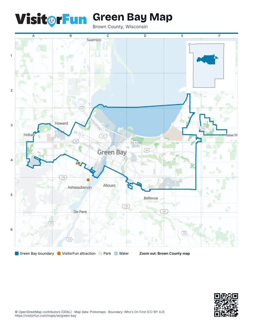
Street index of Green Bay
Each street on the sheet and the grid squares it crosses.
- Leo Frigo BridgeC3
- West Mason StreetA3, B3, A4, B4, C4
- Main StreetC4, D4, D5
- University AvenueD3, C4, D4
- Dousman StreetB3, C3, C4
- Shawano AvenueB3, C3, C4
- Velp AvenueB3, C3
- Algoma RoadE3, F3
- Mather StreetB3, C3
- East Walnut StreetC4
- Chicago StreetC4, D4
- South Monroe AvenueC4
- North BroadwayC3, C4
- South Quincy StreetC4
- West Walnut StreetC4
- North Monroe AvenueC4
- East Mason StreetC4, D4, E4, E5
- Huron RoadE4, E5
- Nicolet DriveE2, D3, E3
- Packerland DriveB3, B4
- Finger RoadD4, E4
- South Military AvenueB3, B4
- South Ashland AvenueC4
- East Shore DriveD3
- Bay Settlement RoadE3, E4
- North Webster AvenueC3, D3, C4
- Lombardi AvenueB4, C4
- North Military AvenueB3, C3
- South Webster AvenueC4
- Lime Kiln RoadD4, D5
- South Madison StreetC4
- Scottwood DriveE3
- Pine StreetC4
- South Jefferson StreetC4
- North Madison StreetC4
- University WayD4
- Military Access RoadB4
- North Jefferson StreetC4
- Nicolet RoadE2
- North Packerland DriveB3
- Humboldt RoadD4, E4
- 9th StreetB4, C4
- Deckner AvenueC4, D4
- South Oneida StreetC3, B4, C4
- South BroadwayC4
- West Point RoadA4, B4
- Crooks StreetC4, D4
- Alpine DriveD4, D5
- Atkinson DriveC3
- Danz AvenueD3, D4
- North Quincy StreetC3, C4
- South Taylor StreetB3, B4
- Hillcrest DriveA3, A4
- North Baird StreetD3, C4, D4
- South Baird StreetC4
- Porlier StreetC4
- Bellevue StreetC4, D4
- Hazelwood LaneA4, B4
- South Point RoadA4
- North Ashland AvenueC3, C4
- South Adams StreetC4
- North Taylor StreetB3
- Cormier RoadA4, B4
- South Washington StreetC4
- North Adams StreetC4
- Verlin RoadD5
- North Washington StreetC4
- North Danz AvenueD4
- Taylor StreetB3
- Washington WayC4
- Bond StreetB3, C3, C4
- Eastman AvenueC4, D4
- Biemeret StreetB4, C4
- Newberry AvenueD4
- Kellogg StreetB3, C3, C4
- Western AvenueB3, C4
- Langlade AvenueB4, C4
- Erie RoadE4, E5
- Mason Street Frontage RoadA3, B3, B4
- South Grandview RoadE4, E5
- Liberty StreetB4, C4
- Hurlbut StreetC3
- Cass StreetC4, D4
- South Northview RoadE4, E5
- North Irwin AvenueD3, C4, D4
- 12th AvenueB4, C4
- Radisson StreetC3, D3, D4
- Elmore StreetB3, C3, C4
- Division StreetB3, C3, C4
- South Ridge RoadB4
- Ontario RoadE4, E5
- 14th AvenueB4, C4
- Manitowoc RoadD4, D5
- 7th StreetB4, C4
- Smith StreetC4, D4
- 13th AvenueB4, C4
- Greenbriar RoadD5, E5
- South Fisk StreetB3, B4
- Hillside LaneD4
- Bader StreetD4, D5
- Farlin AvenueD4
- Sussex RoadE3
- Elizabeth StreetD3, D4
- South Jackson StreetC4
- Spartan RoadE3, E4
- Sitka StreetD4, E4
- North Clay StreetC3, C4
- Royal BoulevardC3
- Emilie StreetC4
- Larsen RoadB3
- Saint Agnes DriveB4
- Grignon StreetC4
- South Circle DriveE3
- Gross AvenueB4, C4
- Van Beek RoadD5
- North Locust StreetB3, C3
- South Clay StreetC4
- Eliza StreetC4
- South Roosevelt StreetC4
- South Irwin AvenueC4
- Cherry StreetC4
- Edgewood DriveD4, D5
- Skyline BoulevardD4
- Day StreetC4, D4
- North Platten StreetB3, C3
- Morrow StreetC4, D4
- 11th AvenueC4
- Doty StreetC4
- Oakwood DriveA4, B4
- Baird Creek RoadD4
- Parkwood DriveA4, B4
- Cedar StreetC4, D4
- Spence StreetB4
- Harvey StreetC4, D4
- South Locust StreetB3, B4
- Church RoadE3
- Saint George StreetD3, C4
- Pecan StreetD5
- South Chestnut StreetC4
- Bay Beach RoadC3, D3
- Voyager DriveD5, E5
- Leon Bond DriveE3
- 10th AvenueC4
- Superior RoadD4
- North Henry StreetD4
- Stuart StreetC4
- Hickory Hill DriveB4, C4
- Elm StreetC4, D4
- Laverne DriveD4, E4
- Rockdale StreetB4
- South Oakland AvenueC4
- South Van Buren StreetC4
- Park StreetC3
- Abrams StreetD4
- Country Club RoadA3, A4
- Mobile Home ParkB4, D4
- 8th StreetB4, C4
- South Norwood AvenueC4
- Gray StreetC3, C4
- North Circle DriveE3
- Roscoe StreetB4, C4
- Preble AvenueD4
- North Northview RoadE4
- East Circle DriveE3
- Durham RoadE3
- Hubble DriveD5
- South Maple AvenueC4
- Reed StreetB3, C3, C4
- Lawe StreetC4
- Indian Hill DriveA3, B3
- He Nis Ra LaneA4, B4
- North Maple AvenueC3, C4
- Howard StreetC4
- Harold StreetD4
- South Hemlock RoadF3
- Lacount RoadA3, A4
- Basten StreetD4
- North Van Buren StreetC3, C4
- Thrush StreetC3
- Weise StreetC3, D3, D4
- Challenger DriveE4, E5
- Clinton StreetC4
- Main Entrance DriveE3
- Irene StreetC4, D4
- Debra LaneC4, D4, D5
- Wilson AvenueC3
- Oregon StreetB3, C3, C4
- North Chestnut StreetC3, C4
- Sandia DriveA4
- Curry LaneD3, E3, D4
- Desnoyers StreetC3
- Luxemburg RoadE4
- North Grandview RoadE4
- Ferndale DriveA4
- Eastbound West Mason Frontage RoadA3, B3
- Reber StreetC4, D4
- Klaus StreetC3, D4
- Windland DriveE4
- Minahan StreetC3
- Student Center BoulevardA3, B3
- Lake Largo DriveE3, E4
- Christiana StreetB3, C4
- Columbia AvenueC3
- Fiesta LaneC4, D4, D5
- Amy StreetC4, D4
- Vanderbraak StreetC3, C4, D4
- Goodell StreetC4
- Bylsby AvenueC3
- Beth DriveD4, E4
- Brosig StreetD5
- Schwartz StreetD4
- Cornelius DriveE4
- Juniper DriveC4, D4, D5
- 6th StreetB4, C4
- Gershwin DriveE3
- Saint Anthony DriveD3, D4
- Lilac LaneC4, D4
- Haven PlaceA4
- Schoen StreetD4
- Saint Ann DriveD4
- Boland RoadB3
- Prairie AvenueC3
- Lowell DriveD5, E5
- 5th StreetC4
- Heyrman StreetC4, D4
- School PlaceC4
- Lakeside PlaceD3
- North Fisk StreetB3
- Trojan DriveA4, B4
- Cofrin DriveD4
- Shadow LaneB4
- State StreetC4
- Hutson RoadB3
- Aphrodite RoadD4, D5
- 3rd StreetC4
- Forestville DriveA4, B4
- Thorndale StreetB4
- Eastman ParkC4
- Sherry LaneD4
- Berner StreetC4, D4
- Redwood DriveB4, C4
- Beech Tree DriveB4
- Marquette AvenueB4, C4
- Thomas StreetC3
- Sunrise CourtD4
- Meacham StreetB4
- James StreetC3
- Donald StreetC3
- Edinburgh RoadE3
- North Buchanan StreetC3
- Kimball StreetC4, D4
- Swiss Hill DriveD4
- Winford AvenueC3
- Argonne DriveB4
- Badger StreetB3, C4
- Victoria StreetD4
- Wiesner StreetB4
- Edison StreetC4, D4
- Nancy AvenueB3
- North Jackson StreetC4
- Kenwood StreetB4
- Raleigh StreetB4
- Van Deuren StreetD4
- Walker DriveD5, E5
- Nicolet AvenueB4, C4
- Oakdale AvenueD4
- Ethel AvenueC3
- Lark StreetC3
- Dancing Dunes DriveA4
- Kepler DriveD5
- Colonial AvenueB4
- Open Gate TrailA3
- Ironwood DriveB4
- Marshall AvenueC3
- Mount Mary DriveD4
- Courier RoadE4
- Walter WayE3
- Gilbert DriveD4, E4
- Newtols StreetD4
- Huth StreetD4
- Wesley AvenueD4
- Yeager DriveE5
- Remington RoadD4
- Northern AvenueC3
- Kennedy DriveB4
- Sage DriveD4
- Wood LaneB4
- Wirtz AvenueB4, C4
- Richardson StreetC3
- Hinkle StreetB3
- Wiggins WayE3
- Hubbard StreetC4
- 15th AvenueC4
- West Mason St Frontage RoadA3
- John StreetC4, D4
- Hobart DriveB3, B4
- Wildwood DriveD4
- Moon Valley DriveD4
- Guns StreetD5
- Russell StreetB4
Things to do on the Green Bay map
Places on the map
- Admiral Flatley Park
- Arnie Wolff Sports Complex
- Astor
- Astor East
- Aurora BayCare Health Center
- Aurora BayCare Medical Center
- Baird Creek Greenway
- Barnia Parkway
- Bay Beach Wildlife Sanctuary
- Bellin Hospital Green Bay
- Brown County Jail
- Brown County Nursing Home
- Cofrin Arboretum
- Colburn
- Colburn Park
- David A Cofrin Library
- Downtown
- East Shore Drive
- Firemans Park
- Fort Howard
- Fritsch Park
- Joannes Park
- John Muir Park
- Ken Euers Nature Area
- King of Arms
- Lombardi
- MacArthur Heights
- Maple Arches
- Marquette Park
- Navarino
- Northwest Railway Gardens
- Olde Norwood
- Oneida Golf & Country Club
- Perkins Park
- Red Smith
- Seymour Park
- Sisters of Saint Francis
- Tank Park
- Western Corridor
- Whitney Park
Next to Green Bay
- Allouez
- Ashwaubenon
- Bellevue
- De Pere
- Hobart
- Howard
- New Franken
- Suamico
© OpenStreetMap contributors, Open Database License, openstreetmap.org/copyright · Map data: Protomaps · Boundary: Who's On First (CC-BY 4.0)