

Wisconsin map
Kenosha map
About 99,578 people live here (Census Bureau, 2024 estimate). The sheet's index lists 300 streets; 52nd Street, 67th Street and 74th Street cross the most grid squares. Also on it: Kenosha Regional Airport, Pennoyer Park and Poerio Park.
Open the map (PDF, US Letter)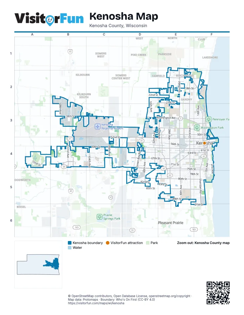
Street index of Kenosha
Each street on the sheet and the grid squares it crosses.
- 52nd StreetB3, C3, C4, D4, E4, F4
- Sheridan RoadF2, F3, F4, F5, F6
- 75th StreetA4, B4, E4, F4
- Washington RoadD3, E3, F3
- Green Bay RoadD3, D4, D5
- 63rd StreetC4, D4, E4, F4
- State Highway 50D4, E4
- Alford Park DriveF2, F3
- Roosevelt RoadE4, E5
- Burlington RoadB2
- 39th AvenueE1, E2, E3, E4, E5
- 88th AvenueC3, C4
- 60th StreetB4, C4, D4, E4, F4
- 22nd AvenueE1, E2, E3, E4, E5
- Wood RoadE1, E2, E3, E4
- 67th StreetA4, B4, C4, D4, E4, F4
- 7th AvenueF3, F4, F5
- 56th StreetD4, E4, F4
- 47th AvenueE2, E3, E4, E5
- 71st StreetB4, C4, D4, E4, F4
- 45th StreetC3, D3, E3, F3
- 50th StreetC3, D3, E3, F3
- 38th StreetB3, C3, E3, F3
- Pershing BoulevardE3, E4, E5
- 61st StreetC4, D4, E4, F4
- 74th StreetA4, B4, C4, D4, E4, F4
- 80th StreetD5, E5, F5
- 8th AvenueF3, F4, F5, F6
- 30th AvenueE4, E5
- 122nd AvenueB3, B4
- 120th AvenueB2, B3, B4
- 60th AvenueD4, D5
- 85th StreetD5, E5, F5
- 89th StreetE5, F5
- 27th StreetD2, E2, F2
- 104th AvenueC3, C4
- 52nd AvenueD2, D3, D4
- 54th StreetD4, E4, F4
- 58th StreetD4, E4, F4
- 6th AvenueF3, F4, F5
- 18th StreetE2, F2
- West Frontage RoadB2, B3, B4
- 15th StreetE2, F2
- 51st AvenueD3, D4
- 118th AvenueB4
- 77th AvenueD4
- 91st StreetF6
- 4th AvenueF3, F4
- Birch RoadE2, F2
- 14th StreetE2
- 125th AvenueB4
- 156th AvenueA4
- 123rd AvenueB4
- 59th PlaceF4
- Ring RoadF4
- 6th Avenue AF4
- 18th AvenueF1, F2, F3, F4, F5
- 17th AvenueF2, F3, F4, F5, F6
- 14th AvenueF2, F3, F4, F5
- 19th AvenueE2, E3, E4, F4, F5
- 32nd AvenueE2, E3, E4, E5
- 25th AvenueE2, E3, E4, E5
- 26th AvenueE2, E3, E4, E5
- 21st AvenueE2, E3, E4, E5
- 23rd AvenueE2, E3, E4, E5
- 20th AvenueE1, E2, E3, E4, E5
- 24th AvenueE2, E3, E4, E5
- 28th AvenueE2, E3, E4, E5
- 16th AvenueF2, F3, F4, F5, F6
- 34th AvenueE2, E3, E4, E5
- 55th StreetC4, D4, E4, F4
- 35th AvenueE2, E3, E4, E5
- 65th StreetB4, C4, D4, E4, F4
- 73rd StreetA4, C4, D4, E4, F4
- 69th StreetA4, B4, C4, D4, E4, F4
- 31st AvenueE3, E4, E5
- 29th AvenueE2, E3, E4, E5
- 40th AvenueE1, E2, E3, E4, E5
- 33rd AvenueE3, E4, E5, E6
- 27th AvenueE2, E3, E4, E5
- 68th StreetA4, C4, D4, E4, F4
- 43rd AvenueE2, E3, E4, E5
- 38th AvenueE2, E3, E4, E5
- 5th AvenueF3, F4, F5
- 79th StreetD5, E5, F5
- 64th StreetB4, C4, D4, E4, F4
- 37th AvenueE2, E3, E4, E5
- 53rd StreetD4, E4, F4
- 76th StreetD4, D5, E5, F5
- 10th AvenueF3, F4, F5
- 15th AvenueF2, F4, F5, F6
- 36th AvenueE2, E3, E4, E5
- 70th StreetA4, C4, D4, E4, F4
- 45th AvenueE2, E3, E4, E5
- 42nd AvenueE2, E3, E4, E5
- 43rd StreetC3, D3, E3, F3
- 46th AvenueE2, E3, E4, E5
- 78th StreetD5, E5, F5
- 24th StreetE2, F2
- 57th StreetD4, E4, F4
- 66th StreetB4, C4, D4, E4, F4
- 55th AvenueD2, D3, D4
- 11th AvenueF3, F4, F6
- 13th AvenueF3, F4
- 57th AvenueD3, D4, D5
- 3rd AvenueF4, F5
- 46th StreetD3, E3, F3
- 49th AvenueD4, E4, D5, E5
- 56th AvenueD3, D4
- 81st StreetD5, E5, F5
- 62nd StreetB4, C4, D4, E4, F4
- 72nd StreetA4, C4, D4, E4, F4
- 35th StreetD3, E3, F3
- 48th AvenueD2, E2, D3, E4, E5
- 50th AvenueD2, D3, D4, D5
- 29th StreetB2, B3, E3, F3
- 41st AvenueE2, E4, E5
- 128th AvenueB2, B3, B4
- 40th StreetD3, E3, F3
- 22nd StreetD2, E2, F2
- 83rd StreetD5, E5, F5
- 44th AvenueE2, E3, E4, E5
- 31st StreetD3, E3, F3
- 25th StreetD2, E2, F2
- 30th StreetE3, F3
- 87th PlaceE5, F5
- 48th StreetE3, F3
- Kennedy DriveF3
- 82nd StreetD5, E5, F5
- 59th StreetE4, F4
- 41st StreetD3, E3, F3
- 54th AvenueD3, D4
- 58th PlaceC4
- 51st StreetD3, E3, F3
- 26th StreetD2, E2, F2
- 95th AvenueC3, C4
- Lincoln RoadE5
- 28th StreetD2, E3, F3
- 144th AvenueA4
- 34th StreetD3, E3, F3
- 21st StreetE2, F2
- 16th PlaceE2, F2
- 70th AvenueD3, D4, D5
- 77th StreetD5, E5, F5
- 74th PlaceB4, C4, D4, E4, F4
- 2nd AvenueF4, F5
- 68th AvenueD3, D4, D5
- 88th PlaceE5, F5
- 96th AvenueC4
- 80th PlaceD5, E5, F5
- 87th StreetE5, F5
- 42nd StreetD3, E3, F3
- Campus DriveF2
- 99th AvenueC4
- 44th StreetE3, F3
- 66th PlaceA4, B4, D4, F4
- Ruth Harman DriveC3
- 53rd AvenueD3, D4
- 37th StreetE3, F3
- 94th AvenueC4
- 33rd StreetD3, E3, F3
- 32nd StreetD3, E3, F3
- 58th AvenueD4
- 20th PlaceE2
- 111th AvenueB4
- 12th AvenueF4, F5
- Wilson RoadE4
- 28th PlaceD3, E3
- Harding RoadE4
- 23rd StreetE2, F2
- 88th StreetE5, F5
- 13th CourtF3, F4
- 13th StreetE2, F2
- 64th AvenueD4, D5
- 59th AvenueD4
- 61st PlaceB4, C4
- 86th PlaceE5, F5
- 106th AvenueC4
- 86th StreetE5
- 27th CourtE3, E4
- 47th CourtD2, E2, E5
- 67th PlaceB4, C4, D4, E4, F4
- Taft RoadE4
- 115th AvenueB4
- 70th CourtD4
- 94th CourtC4
- 39th StreetD3, E3, F3
- 49th StreetD3, F3
- 84th StreetD5, E5, F5
- 92nd AvenueC4
- 13th PlaceE2, F2
- Harrison RoadE4
- 19th StreetE2, F2
- 60th PlaceB4, C4, E4
- Uline WayB3
- 16th StreetE2, F2
- 35th PlaceE3, F3
- 36th StreetE3, F3
- 90th StreetE5, F5
- 25th CourtE5
- 93rd AvenueC4
- 141st AvenueA4
- 83rd PlaceD5, E5
- 47th StreetE3, F3
- 63rd AvenueD4, D5
- 65th PlaceC4, D4
- 68th PlaceB4, E4, F4
- Southeast Service RoadE5
- 24th PlaceD2
- 82nd AvenueC4
- 1st AvenueF4
- 30th CourtE1, E2
- 17th StreetE2, F2
- 85th AvenueC4
- 61st AvenueD4, D5
- 103rd AvenueC4
- 85th PlaceE5
- 78th PlaceD5, E5, F5
- 114th AvenueB4
- 14th LaneE2
- 44th CourtE2, E3, E4
- 91st AvenueC3, C4
- 23rd PlaceD2, E2
- Buchanan RoadE5
- Walnut LaneF5
- 14th PlaceE2
- 62nd PlaceC4
- 89th PlaceE5, F5
- 100th AvenueC4
- 84th AvenueC4
- 108th AvenueB4
- 112th AvenueB4
- 97th AvenueC4
- 83rd AvenueC4
- Simmons Island RoadF3
- 40th CourtE2
- 152nd AvenueA4
- 15th PlaceE2, F2
- 150th AvenueA4
- 102nd AvenueC4
- 105th AvenueC4
- Madison RoadE2, F2
- Evergreen LaneF5
- 18th PlaceE2, F2
- 19th PlaceE2
- 82nd PlaceD5
- 155th AvenueA4
- Johnson RoadE5
- 55th CourtD3
- 154th AvenueA4
- Adams RoadD3
- 29th PlaceD3
- 87th AvenueC4
- 40th PlaceF3
- 65th AvenueD4, D5
- 130th AvenueB4
- Martin Luther King DriveE4, F4
- 53rd CourtD2, D4
- Hickory LaneF5
- 51st PlaceF3, F4
- 98th AvenueC4
- 38th CourtE2
- 32nd CourtE2
- 15th CourtF2
- Oakwood CircleF5
- 62nd AvenueD4, D5
- 9th AvenueF4
- 34th CourtE2
- 107th AvenueB4, C4
- 84th PlaceF5
- Van Buren RoadE5
- 29th CourtE2, E5
- 69th AvenueD5
- 145th AvenueA4
- 93rd CourtC4
- 31st CourtE5
- 75th PlaceD4
- 142nd AvenueA4
- 44th PlaceE3
- 147th AvenueA4
- 143rd CourtA4
- 63rd PlaceE4
- 73rd PlaceE4
- 148th AvenueA4
- 56th CourtD4
- 109th AvenueB4
- 13th LaneE2
- 71st PlaceA4
- 12th PlaceE1, F1
- 155th CourtA4
- 91st CourtC3
- Frontage RoadF4
- Poplar laneF5
- Chestnut LaneF5
- 95th StreetC4
- 28th CourtE2
- Birch LaneF5
- 14th CourtF4
- 9th CourtF5
- 53rd PlaceB4
Places on the map
- Alford Park
- Alford Park Beach
- Anderson Park
- Anderson Pond
- Aurora Medical Center
- Bose Elementary School
- Bullen Middle School
- Christian Life
- East Ramp
- Eichelman Beach
- Eichelman Park
- Forest Park Elementary School
- Froedtert Kenosha Hospital
- Greenridge Cemetery
- Harbor Park
- Harvey Elementary School
- Indian Trail High School
- Indian Trail Plaza
- Jeffery Elementary School
- Journey Church
- Kenosha Correctional Center
- Kenosha County Detention Center
- Kenosha Regional Airport
- Lance Middle School
- Lincoln Park
- Lowe's
- Mary D. Bradford High School
- Meijer
- North Ramp
- Pennoyer Beach
- Pennoyer Park
- Petzke Park
- Poerio Park
- Rust-Oleum
- Saint George Cemetery
- Simmons Island Beach
- Simmons Island Park
- South Ramp
- The Club at Strawberry Creek
- Washington Park
Next to Kenosha
- Birchwood
- Bissel
- Country Club
- Farfield
- Kilbourn
- Kilbourn South
- Lakeshore
- Parkside
- Parkside East
- Pike Creek
- Pike River West
- Pleasant Prairie map
- Somers Center East
- Somers Center West
- Somers West
- Southwest
- Woodworth
© OpenStreetMap contributors, Open Database License, openstreetmap.org/copyright · Map data: Protomaps · Boundary: Who's On First (CC-BY 4.0)















