

Wisconsin map
Kenosha County map
About 168,754 people live here (Census Bureau, 2024 estimate). The sheet's index lists 300 streets; 60th Street, 110th Street and 63rd Street cross the most grid squares. Things to do inside the boundary: Kenosha.
Open the map (PDF, US Letter)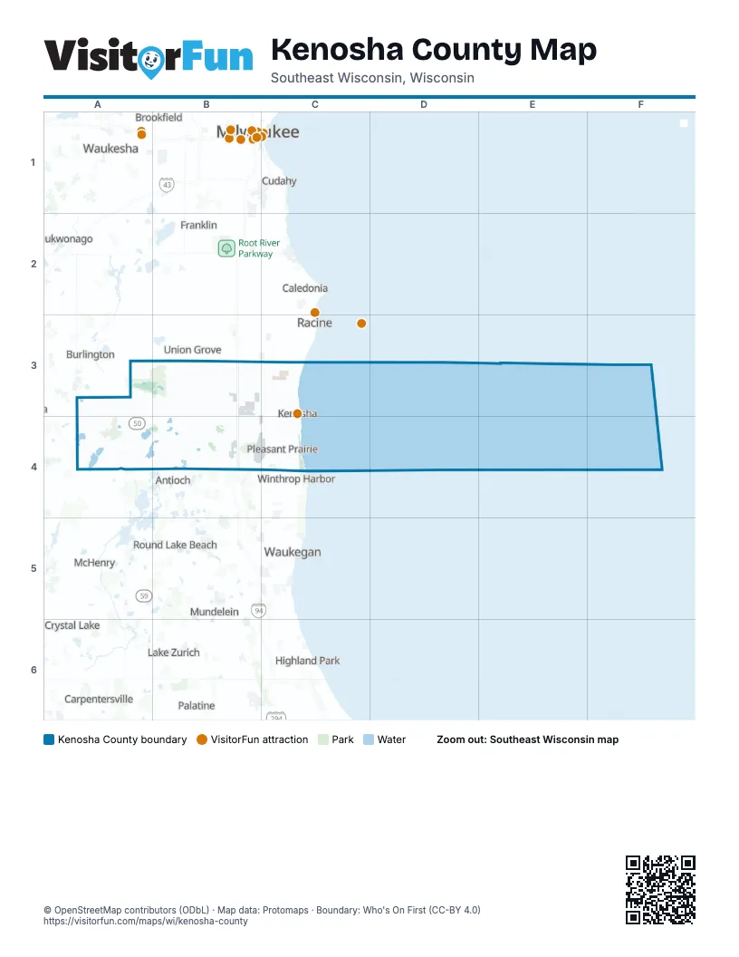
Maps inside Kenosha County
3 maps inside, from the street map of Kenosha County down.
City
Street index of Kenosha County
Each street on the sheet and the grid squares it crosses.
- 75th StreetB4, C4, D4, E4, F4
- Green Bay RoadE2, E3, E4, E5
- 104th StreetA4, C4, D4, E4, F4
- Burlington RoadC3, D3, E3, A5
- Sheridan RoadF2, F3, F4, F5
- 52nd StreetA3, B3, C3, E3, F3
- State Highway 50A3, B3, E4, F4
- 200th AvenueC2, D2, D3, D4
- Geneva RoadA3, B3, A4, B4
- Washington RoadE3, F3
- Antioch RoadC4, C5
- Bristol RoadD3, D4, D5
- 63rd StreetC3, D3, B4, C4, E4, F4
- State Highway 142B3, C3
- Roosevelt RoadA4, E4, F4
- Alford Park DriveF3
- State Highway 31E2
- State Highway 83B3
- North Green Bay RoadE5
- US Highway 45D5
- 120th AvenueE2, E3, E4, E5
- 88th AvenueE2, E3, E4, E5
- 12th StreetD3, E3, F3
- 39th AvenueF2, F3, F4, F5
- Fox River RoadB4, B5
- 122nd AvenueE3, E4, E5
- 288th AvenueB2, B3, B4, B5
- Bassett RoadA4, B4, C4
- County Highway PA3, A4
- State Highway 75C3, C4
- 368th StreetA3, A4
- County Line RoadE2, F2
- Richmond RoadA4, A5
- Lance DriveA4
- North Lake AvenueA4
- Cogswell DriveB4
- Frontage Road/120th AvenueE5
- East Main StreetA4
- North Cogswell DriveB4
- North Lewis AvenueF5
- 360th AvenueA4
- West Wilmot RoadB5
- North Kilbourn RoadE5
- McHenry StreetA3
- 60th StreetA3, B3, C3, D3, E3, F3, F4
- Wilmot RoadC4, D4, E4, A5, B5, C5
- 7th StreetB2, C2, D2, E2, F2, B4
- 31st StreetA3, B3, C3, D3, E3, F3
- 22nd AvenueF2, F3, F4, F5
- 116th StreetA5, B5, C5, D5, E5, F5
- 47th AvenueE2, E3, E4, F4, F5
- 45th StreetA3, B3, C3, D3, E3, F3
- 18th StreetC3, E3, F3
- Wood RoadF2, F3, F4
- 136th AvenueD2, D3, D4, D5
- West Frontage RoadE2, E3, E4
- 38th StreetD3, E3, F3
- 93rd StreetA4, C4, E4, F4
- 122nd StreetB5, C5, D5, E5, F5
- 67th StreetB4, C4, D4, E4, F4
- 7th AvenueF3, F4
- Salem RoadC3, C4, D4
- 72nd AvenueE2, E3, E4
- 128th StreetC5, D5, E5
- Old Green Bay RoadE2, E4, E5
- Springbrook RoadF4, E5
- 152nd AvenueD3, D4, D5
- 76th StreetB4, C4, E4, F4
- 312th AvenueB2, B3, B4
- 98th StreetB4, C4, D4, E4, F4
- 80th StreetB4, D4, E4, F4
- 224th AvenueC2, C3, C4, C5
- 56th StreetE3, F3
- 84th StreetA4, C4, D4, E4, F4
- 85th StreetA4, C4, E4, F4
- 110th StreetA4, B4, C4, E4, A5, E5, F5
- 83rd StreetC4, D4, E4, F4
- 73rd StreetB4, C4, D4, E4, F4
- 71st StreetB4, C4, D4, E4, F4
- 352nd AvenueB3, B4
- 8th AvenueF3, F4, F5
- 80th AvenueE3, E4, E5
- 172nd AvenueD2, D3
- 107th StreetB4, C4, D4, E4, F4
- 29th AvenueF3, F4
- 1st Street / County Line RoadC2, D2
- Wilmot AvenueA4, A5, B5
- 61st StreetC3, E3, E4, F4
- 50th StreetE3, F3
- 74th StreetC4, D4, E4, F4
- 104th AvenueE3, E4
- 336th AvenueB4, B5
- Russell RoadE5, F5
- Horton RoadD4, D5
- 240th AvenueC3, C4, C5
- 160th AvenueD4
- 77th StreetB4, C4, D4, E4, F4
- 184th AvenueD3, D4, D5
- 91st StreetA4, C4, D4, E4, F4
- 87th StreetA4, C4, D4, E4, F4
- 119th StreetA5, B5, C5, D5, F5
- 30th AvenueF2, F4
- Cooper RoadE4
- Pershing BoulevardF3, F4
- 125th StreetA5, B5, C5, E5, F5
- 89th StreetA4, D4, E4, F4
- 60th AvenueE2, E3, E4
- 176th AvenueD3, D4
- East Lake Shore DriveA4, A5
- County Highway WB3, B4
- 264th AvenueC2, C3, C4, C5
- 103rd StreetA4, B4, C4, D4, E4, F4
- 52nd AvenueE3, E4
- 232nd AvenueC3, C5
- Frontage RoadF3, E4, F5
- 256th AvenueC4, C5
- 328th AvenueB4
- Camp Lake RoadC4
- 4th AvenueF3, F4, D5, F5
- 296th AvenueB2, B3, B4
- 100th StreetB4, C4, E4, F4
- 94th AvenueE3, E4
- 27th StreetE3, F3
- Prairie Ridge BoulevardE4
- 95th StreetA4, C4, E4, F4
- County Highway CE4, B5
- 388th AvenueA4
- 46th StreetD3, E3, F3
- 109th StreetB4, C4, E4, F4, F5
- 180th AvenueD2, D3
- Silver Lake RoadC4
- 54th StreetB3, E3, F3
- 15th StreetE3, F3
- 58th StreetE3, F3
- 6th AvenueF3, F4
- 216th AvenueC3, C4, C5
- West Main StreetA4
- 108th StreetB4, C4, E4, F4
- 118th AvenueE3, E4
- Winfield RoadD4, D5
- Petrifying Springs RoadE2, E3, F3
- County Highway ND3
- 85th PlaceC4, E4, F4
- 14th StreetE3, F3
- 304th AvenueB4, B5
- 280th AvenueB3, B5
- 51st AvenueE3, E4
- 156th AvenueD3, D4
- 348th AvenueB3
- South English Settlement DriveB2
- Legion DriveA4, B4
- Bloomfield RoadA4
- West Russell RoadE5
- Tuttle RoadB4, B5
- 77th AvenueE4
- 1st StreetD2, E2, B4, A5, D5
- Birch RoadF3
- 125th AvenueD4
- 168th AvenueD4
- Rock Lake RoadC5
- 395th AvenueA4
- 6th PlaceE2, F2
- 123rd AvenueE4
- North Bloomfield RoadA4
- Holy Hill RoadA4
- 260th AvenueC5
- 258th CourtC4, C5
- North Hunt Club RoadD5
- Meachem RoadF2
- East Frontage RoadE3
- Dabbs Farm RoadE4
- North Deep Lake RoadC5
- South Lake AvenueA4
- 374th AvenueA3, A5
- North Crawford RoadD5
- 239th AvenueC3, C4, C5
- 258th StreetC5
- 258th AvenueC4, C5
- South RoadA5
- County Highway BA4
- 59th PlaceF3
- Ring RoadF3
- 6th Avenue AF3
- South Sylvania AvenueE2
- West North AvenueD5
- 32nd AvenueF3, F4, F5
- 43rd AvenueF2, F3, F4, F5
- 82nd StreetB4, C4, D4, E4, F4
- 26th AvenueF2, F3, F4, F5
- 100th AvenueE2, E3, E4
- 28th AvenueF2, F3, F4, F5
- 14th AvenueF3, F4, F5
- 18th AvenueF3, F4
- 25th AvenueF2, F3, F4, F5
- 81st StreetA4, B4, C4, D4, E4, F4
- 17th AvenueF3, F4
- 3rd AvenueF3, F4, D5, F5
- 19th AvenueF3, F4
- 128th AvenueD3, D4
- 23rd AvenueF2, F3, F4, F5
- 65th StreetA4, C4, E4, F4
- 24th AvenueF3, F4
- 35th AvenueF3, F4, F5
- 20th AvenueF2, F3, F4
- 21st AvenueF3, F4
- 34th AvenueF3, F4, F5
- 79th StreetB4, D4, E4, F4
- 69th StreetB4, C4, D4, E4, F4
- 55th StreetA3, E3, F3
- 45th AvenueE3, F3, F4, F5
- 16th AvenueF3, F4
- 42nd AvenueF3, F4, F5
- 68th StreetC4, D4, E4, F4
- 11th AvenueF2, F3, F4, F5
- 33rd AvenueF2, F3, F4
- Lakeshore DriveF4, F5
- 41st StreetB3, C3, E3, F3
- 41st AvenueF3, F4, F5
- 64th StreetB4, C4, E4, F4
- 37th AvenueF2, F3, F4, F5
- 38th AvenueF2, F3, F4, F5
- 27th AvenueF3, F4
- 31st AvenueF3, F4
- 40th AvenueF3, F4, F5
- 70th StreetB4, C4, D4, E4, F4
- 5th AvenueF3, F4, D5
- 13th AvenueF2, F3, F4
- 56th AvenueE2, E3, E4
- 144th AvenueD2, D3, D4
- 48th AvenueE3, E4
- 10th AvenueF3, F4, F5
- 43rd StreetE3, F3
- 49th AvenueE2, E3, E4
- 53rd StreetA3, E3, F3
- 55th AvenueE3, E4
- 78th StreetC4, D4, E4, F4
- 376th AvenueA3, A4
- 36th AvenueF3, F4, F5
- 113th StreetB5, C5, E5, F5
- 66th StreetC4, E4, F4
- 15th AvenueF3, F4
- 392nd AvenueA3, A4
- 46th AvenueE3, E4, F4
- 101st StreetA4, B4, C4, D4, E4, F4
- 57th StreetA3, B3, E3, F3
- Happy Acres RoadC3
- 248th AvenueC3, C4
- Bain Station RoadE4
- 86th StreetC4, D4, E4, F4
- 72nd StreetC4, D4, E4, F4
- 35th StreetE3, F3
- 368th AvenueA3
- 50th AvenueE3, E4
- 88th StreetA4, C4, E4, F4
- 106th StreetA4, B4, C4, D4, E4, F4
- 57th AvenueE2, E3, E4
- 24th StreetE3, F3
- 102nd StreetA4, B4, D4, E4, F4
- 62nd StreetC4, E4, F4
- 54th AvenueE3, E4
- 83rd PlaceC4, D4, E4, F4
- 87th PlaceA4, E4, F4
- 115th StreetB5, C5, F5
- 2nd AvenueF3, F4, D5, F5
- 63rd AvenueE3, E4, E5
- 44th AvenueF3, F4, F5
- 308th AvenueB3, B5
- 90th StreetA4, C4, D4, E4, F4
- 121st StreetC5, D5, F5
- 86th PlaceC4, D4, E4, F4
- 51st StreetB3, E3, F3
- 235th AvenueC3, C4, C5
- 269th AvenueC4, C5
- 9th StreetC2, F2
- 400th AvenueA4, A5
- 120th StreetB5, C5, D5, F5
- 118th StreetB5, C5, F5
- 22nd StreetE3, F3
- 4th StreetE2, F2, D5
- 112th StreetB5, C5, F5
- 64th AvenueE3, E4, E5
- 16th PlaceE3, F3
- 29th StreetE3, F3
- Kennedy DriveF3, A4
- Vandenboom RoadC2, C3
- 48th StreetB3, E3, F3
- University DriveF2, F3
- 97th StreetB4, C4, E4, F4
- Main StreetE4, F4
- 25th StreetE3, F3
- 236th AvenueC3, C4, C5
- 89th PlaceA4, C4, E4, F4
- 34th StreetE3, F3
- 40th StreetE3, F3
- 59th StreetB3, F3
- Wheatland Estates RoadB3
- 95th AvenueE3, E4
- 30th StreetE3, F3
- 286th AvenueB4, B5
- 1st CourtF5
Things to do on the Kenosha County map
Places on the map
- Benedict Lake
- Big Oaks Golf Course
- Brighton Dale Links
- Brighton Dale Park
- Bristol
- Bristol Oaks Golf Club
- Bristol Woods County Park
- Camp Lake
- Camp Sol R. Crown
- Center Lake
- Chiwaukee Prairie State Natural Area
- Country Club Trails
- Cross Lake
- Des Plaines River Open Space Land
- Fox River Park
- George Lake
- Great Lakes Dragaway
- Hooker Lake
- Kenosha
- Kenosha Country Club
- Kenosha Regional Airport
- Lake Andrea
- Lake Elizabeth
- Lake Mary
- Lake Shangrila
- Lily Lake
- Montgomery Lake
- New Munster Wildlife Area
- Nippersink Resort
- Paddock Lake
- Pennoyer Park
- Petrifying Springs County Park
- Petrifying Springs Golf Course
- Pleasant Prairie
- Poerio Park
- Powers Lake
- Prairie Springs Park
- Richard Bong State Recreation Area
- Salem Lakes
- Silver Lake
Next to Kenosha County
- Antioch
- Beach Park
- Burlington map
- Lindenhurst
- Mount Pleasant map
- Racine map
- Union Grove
- Winthrop Harbor
- Zion
© OpenStreetMap contributors, Open Database License, openstreetmap.org/copyright · Map data: Protomaps · Boundary: Who's On First (CC-BY 4.0); Quattroshapes (CC BY 2.0)















