

Wisconsin map
Pleasant Prairie map
About 21,802 people live here (Census Bureau, 2024 estimate). The sheet's index lists 283 streets; 120th Avenue, 104th Street and 122nd Street cross the most grid squares. Also on it: Big Oaks Golf Course, Chiwaukee Prairie State Natural Area and Des Plaines River Open Space Land.
Open the map (PDF, US Letter)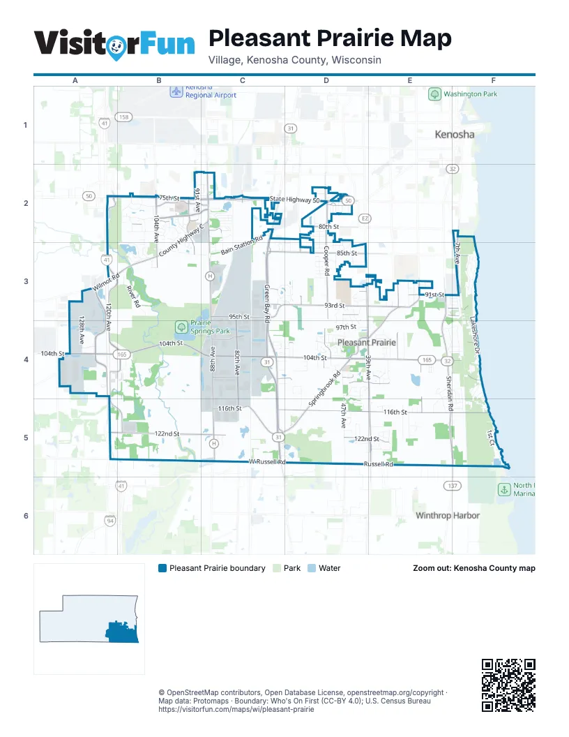
Street index of Pleasant Prairie
Each street on the sheet and the grid squares it crosses.
- 118th AvenueA2
- 120th AvenueA2, A3, B3, A4, B4, A5, B5
- 75th StreetA2, B2, C2
- 100th AvenueB2
- 102nd AvenueB2
- 103rd AvenueB2, B3
- 104th AvenueB2, B3
- 105th AvenueB2, B3
- 107th AvenueB2, B3
- 108th AvenueB2, B3
- 109th AvenueB2
- 111th AvenueB2, B3
- 112th AvenueB2
- 113th PlaceB2
- 115th AvenueB2
- 117th AvenueB2
- 67th StreetB2, C2
- 70th StreetB2, C2
- 74th StreetB2, C2, D2
- 76th StreetB2, C2, D2
- 77th PlaceB2
- 77th StreetB2, D2
- 78th StreetB2, D2
- 79th PlaceB2
- 79th StreetB2, C2, D2
- 80th AvenueB2, C3, C4, C5
- 80th PlaceB2
- 80th StreetB2, C2, D2
- 81st PlaceB2
- 81st StreetB2, D2
- 82nd PlaceB2, D2
- 82nd StreetB2, C2, D2, F2
- 83rd PlaceB2, C3, D3
- 83rd StreetB2, D2, C3, D3
- 84th PlaceB2, B3
- 84th StreetB2, B3, C3, D3
- 91st AvenueB2
- 94th AvenueB2, B3
- 94th CourtB2, B3
- 96th AvenueB2
- 97th CourtB2
- 98th AvenueB2, B3
- 98th CircleB2
- 99th AvenueB2
- Ashbury LaneB2, B3
- County Highway CB2, C2, B3
- East Ridge DriveB2, B3
- Oak Hi CircleB2, A3, B3
- Prairie Ridge BoulevardB2, C2
- Ridgeway CourtB2
- Seasons PlaceB2
- St. Catherine DriveB2
- West Ridge DriveB2
- 64th CourtC2, D2, D3
- 66th AvenueC2, C3, C4
- 68th StreetC2
- 69th AvenueC2
- 70th AvenueC2
- 70th CourtC2
- 73rd StreetC2, D2
- 75th PlaceC2
- 77th AvenueC2
- 78th PlaceC2
- 83th StreetC2, C3
- 85th AvenueC2, C3, C5
- 88th AvenueC2, C3, C4, C5
- 89th AvenueC2
- Bain Station RoadC2, B3, C3
- Birch DriveC2
- Cedar LaneC2
- Elm CircleC2
- Evergreen DriveC2, E4
- Green Bay RoadC2, C3, C4, C5
- Lexington PlaceC2
- Maple RoadC2
- Mary Ann DriveC2
- McDowell DriveC2
- Oak StreetC2
- Old Green Bay RoadC2, C3, C4, C5
- Pine StreetC2
- Sherry LaneC2
- State Highway 50C2, D2
- Westwood DriveC2
- 43rd AvenueD2, D3, D4, D5
- 45th AvenueD2, D3, D4, D5
- 46th AvenueD2
- 47th AvenueD2, D3, D4, D5
- 47th CourtD2, D3, D4
- 48th AvenueD2, D3, D4
- 49th AvenueD2, D3, D4
- 50th AvenueD2, D3, D4
- 51st AvenueD2
- 52nd AvenueD2, D4
- 54th AvenueD2, D3
- 55th AvenueD2, D4
- 56th AvenueD2, D3
- 57th AvenueD2, D3, D4
- 60th AvenueD2, D3
- 63rd AvenueD2, D3, D4
- 73rd PlaceD2
- Cooper RoadD2, D3, D4
- Harrison RoadD2
- 7th AvenueF2, F3
- 122nd AvenueA3, A4
- 128th AvenueA3, A4
- Frontage RoadA3, E5
- Wilmot RoadA3, B3
- 106th AvenueB3
- 110th AvenueB3
- 113th AvenueB3
- 86th PlaceB3, D3, F3
- 86th StreetB3, D3, F3
- 87th StreetB3, F3
- 88th StreetB3, D3, F3
- 89th PlaceB3, D3, E3
- 89th StreetB3, D3
- 93rd PlaceB3, C3, D3
- Park DriveB3, B4
- River RoadB3
- 65th AvenueC3, D4
- 66th CourtC3
- 72nd AvenueC3, C4
- 85th StreetC3, D3, F3
- 87th AvenueC3, C5
- 91st StreetC3, D3, E3, F3
- 93rd StreetC3, D3, E3, F3
- 95th StreetC3, D3, E3, F3
- Creekside CircleC3, D3
- Dabbs Farm RoadC3
- Terwall TerraceC3, B4, C4
- 39th AvenueD3, D4, E4, E5
- 41st AvenueD3, D4, D5
- 42nd AvenueD3, D4, D5
- 42nd CourtD3, D4
- 49th CourtD3, D4
- 62nd Avenue 82nd AvenueD3
- 62nd CourtD3
- 85th PlaceD3
- 87th PlaceD3, F3
- 90th StreetD3, E3, F3
- 91st PlaceD3, E3, F3
- 92nd PlaceD3, E3, F3
- 94th PlaceD3, E4
- 94th StreetD3, E3, F3
- 96th PlaceD3, D4
- 96th StreetD3, D4, F4
- Beverly LaneD3
- Prairie Village DriveD3
- 11th AvenueE3, E4, F4, F5
- 17th AvenueE3
- 20th AvenueE3
- 22nd AvenueE3, E4, E5
- 24th AvenueE3
- 25th AvenueE3, E5
- 26th AvenueE3, E5
- 27th AvenueE3
- 29th AvenueE3, E4
- 30th AvenueE3
- 32nd AvenueE3, E4, E5
- 34th AvenueE3, E4
- 92nd StreetE3, F3
- Sheridan RoadE3, E4, E5, F5
- Springbrook RoadE3, D4, E4, C5, D5
- 2nd AvenueF3, F4, F5
- 3rd AvenueF3, F4, F5
- 4th AvenueF3, F4, F5
- 4th CourtF3
- 5th AvenueF3
- 8th AvenueF3, F4, F5
- Lakeshore DriveF3, F4, F5
- 104th StreetA4, B4, C4, D4, E4, F4
- 108th StreetA4, B4, D4, E4, F4
- Aurora DriveA4
- Goldbear DriveA4
- Uline DriveA4
- Uline PlaceA4
- 110th StreetB4, C4, D4, E4, F4
- 113th StreetB4, C4, D4, F4
- 116th AvenueB4
- Corporate DriveB4
- 100th PlaceC4, D4
- 100th StreetC4, D4, E4, F4
- 102nd StreetC4, D4, E4, F4
- 105th StreetC4, D4, F4
- 107th StreetC4, D4, E4, F4
- 109th StreetC4, D4, E4
- 78th AvenueC4
- 82nd AvenueC4
- 86th AvenueC4
- 99th PlaceC4
- 99th StreetC4, D4, E4
- Jelly Belly LaneC4
- Meadowlands CircleC4, D4
- 101st PlaceD4, E4
- 101st StreetD4, E4, F4
- 103rd StreetD4, E4, F4
- 105th PlaceD4
- 106th StreetD4, F4
- 107th PlaceD4
- 111th StreetD4, E4, F4
- 40th AvenueD4
- 44th AvenueD4, D5
- 50th CourtD4
- 51st CourtD4
- 53rd CourtD4
- 59th AvenueD4
- 61st AvenueD4, D5
- 64th AvenueD4, D5
- 97th StreetD4, E4, F4
- 98th StreetD4, F4
- Main StreetD4, E4
- MeadowdaleD4
- South Cottage LaneD4
- Springbrook CourtD4
- 106th PlaceE4
- 108th PlaceE4
- 109 StreetE4
- 112th StreetE4, E5
- 14th AvenueE4, E5
- 14th CourtE4
- 28th AvenueE4, E5
- 33rd AvenueE4
- 33rd CourtE4, E5
- 35th AvenueE4, E5
- 36th CourtE4
- 37th AvenueE4, E5
- 38th AvenueE4, E5
- 98th PlaceE4
- Center Street(Pine Lane)E4
- East StreetE4
- North StreetE4
- South Street (Willow Lane)E4
- Tyler RoadE4
- 10th AvenueF4, F5
- 1st AvenueF4, F5
- 1st CourtF4, F5
- 9th AvenueF4, F5
- 120th CourtA5
- 122nd StreetA5, B5, C5, D5, E5, F5
- 116th StreetC5, D5, E5, F5
- 123rd PlaceC5, D5
- 124th StreetC5, D5, E5
- 125th PlaceC5, D5, E5
- 125th StreetC5, E5, F5
- 126th StreetC5, D5, F5
- North Green Bay RoadC5
- North Kilbourn RoadC5
- Timber Ridge DriveC5, D5
- Trumpet Park DriveC5
- West Russell RoadC5, D5
- 114th StreetD5, F5
- 118th StreetD5
- 120th StreetD5
- 121st StreetD5, E5, F5
- 123rd StreetD5
- 126th PlaceD5
- 127th StreetD5, F5
- North Lynndale DriveD5
- North Oakcrest LaneD5
- Russell RoadD5, E5, F5
- 114th PlaceE5
- 115th StreetE5, F5
- 119th StreetE5
- 120th PlaceE5
- 121st PlaceE5
- 23rd AvenueE5
- 24th CourtE5
- 25th CourtE5
- 36th AvenueE5
- Cavin AvenueE5
- College AvenueE5
- Garnett AvenueE5
- Geddes AvenueE5
- Holdridge AvenueE5
- Kirkwood AvenueE5
- North AvenueE5
- North Lewis AvenueE5
- Old Darby LaneE5
- Russell AvenueE5
- Thompson AvenueE5
- Willow Hollow LaneE5
- 9th CourtF5
- Oakdale AvenueF5
Places on the map
- 102nd Street
- All Saints Cemetery
- Aurora Health Center - Pleasant Prairie
- Big Oaks Golf Course
- BMO
- BP Shop
- Chase
- Cheddar's
- Chick-fil-A
- Chili's
- Chiwaukee Prairie State Natural Area
- Corner Bakery
- Costco
- Culver's
- Des Plaines River Open Space Land
- Dick's Sporting Goods
- Dollar Tree
- DoubleTree
- East Plaza
- El Camino
- Fairfield Inn & Suites Kenosha Pleasant Prairie
- Froedert Pleasant Prairie Clinic
- Froedtert Pleasant Prairie Hospital
- Froedtert Pleasant Prairie Hospital Heliport
- Kenosha Rest Area 26 (I-94 WB)
- Lake Andrea
- Lakeview RecPlex
- North Plaza
- Pleasant Prairie Premium Outlets
- Prairie Ridge Clinic
- Prairie Springs Park
- South Plaza
- The UPS Store
Next to Pleasant Prairie
- Kenosha map
- Winthrop Harbor
© OpenStreetMap contributors, Open Database License, openstreetmap.org/copyright · Map data: Protomaps · Boundary: Who's On First (CC-BY 4.0); U.S. Census Bureau















