

Wisconsin map
Oak Creek map
About 38,373 people live here (Census Bureau, 2024 estimate). The sheet's index lists 300 streets; North-South Freeway, South Howell Avenue and South 27th Street cross the most grid squares. Also on it: Oak Creek Parkway, Bender Park and Drexel Town Square.
Open the map (PDF, US Letter)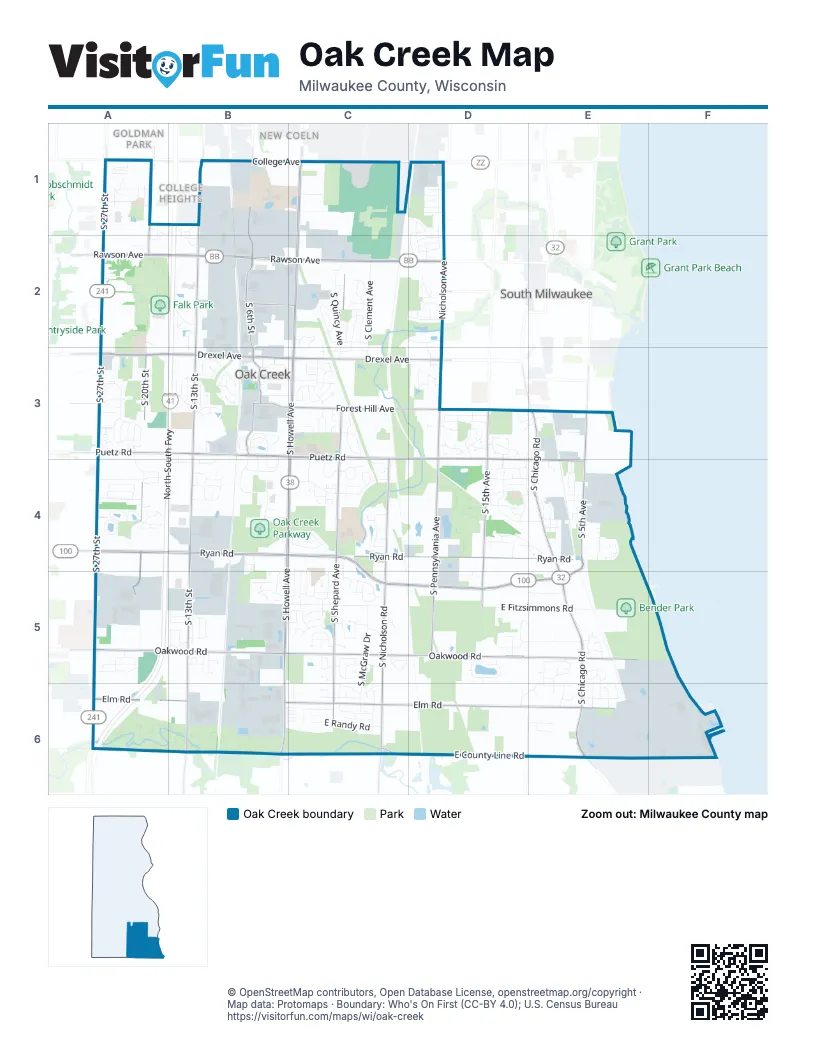
Street index of Oak Creek
Each street on the sheet and the grid squares it crosses.
- North-South FreewayB1, B2, A3, B3, A4, A5, A6
- South Howell AvenueC1, C2, C3, B4, C4, B5, B6
- West Ryan RoadA4, B4, C5, D5, E5
- South 27th StreetA1, A2, A3, A4, A5, A6
- South Chicago RoadE3, E4, E5, E6
- East Ryan RoadB4, C4, D4, E4, C5
- Douglas AvenueE6
- State Highway 38B6
- South 13th StreetB1, B2, B3, B4, B5, B6
- West Rawson AvenueA2, B2, C2
- East Rawson AvenueC2, D2
- Nicholson AvenueD1, D2, D3
- West College AvenueA1, B1, C1
- East College AvenueC1, D1
- West Drexel AvenueA3, B3, C3
- East Oakwood RoadB5, C5, D5, E5
- East Puetz RoadC3, D3, D4, E4
- South Shepard AvenueC2, C3, C4, C5, C6
- East Elm RoadB6, C6, D6, E6
- South Nicholson RoadC3, C4, C5, C6
- West Puetz RoadA3, B3, C3
- South 20th StreetA1, A2, A3, A4, A5
- South Pennsylvania AvenueD3, D4, D5
- South 6th StreetB1, B2, B3
- South 5th AvenueE3, E4, E5
- West Oakwood RoadA5, B5
- East County Line RoadC6, D6, E6
- East Forest Hill AvenueC3, D3
- South 15th AvenueD3, D4, D5
- East Drexel AvenueC3, D3
- West Elm RoadA6, B6
- South Liberty LaneB3
- West Forest Hill AvenueA3, B3, C3
- West Marquette AvenueB2, C2
- Foley RoadD6
- County Highway VB6
- 15th AvenueD5
- Milwaukee AvenueD2
- Drexel BoulevardD3
- Nicholson RoadC6
- East Fitzsimmons RoadB5, C5, D5, E5
- South 10th StreetB1, B2, B3
- West Oakview ParkwayB5, B6
- East Lake Vista BoulevardE4
- South McGraw DriveC5, C6
- South Clement AvenueC2, C3
- South Ikea WayA2, A3
- South Patricia BoulevardD3, D4
- East O'Brien RoadD5, E5
- South Quincy AvenueC2, C3
- East Oak LaneC5, D5, E5
- South Austin StreetC4, C5, C6
- South Verdev DriveC3
- West Hilltop LaneA4
- Southbranch BoulevardA5
- South Crane DriveD1, D2
- East Randy RoadC6
- East American AvenueD4, E4
- South Wildwood DriveB3
- South Apple Creek DriveA3, A4
- West Town Square WayB3, C3
- Fishing Pier RoadE5, E6
- South 11th AvenueD4, E4, D5
- East Oak StreetC1, D1
- South 1st StreetC1, B2
- Briarwood LaneA4
- East Sommers DriveC6
- East Centennial DriveC4
- East Groveland DriveC3
- North Bowl RoadE6, F6
- South 22nd StreetA1, A2, A4
- South Lenox AvenueC2, C3
- East Mahn CourtC2
- West Meyer LaneA4
- South Logan AvenueC2
- East Parkway Estates DriveB4, C4
- South Meyer LaneA4
- East Marquette AvenueC2
- West Violet DriveB3, B4
- East Prairie View DriveC5
- East Golden LaneC4
- South 10th AvenueD6, E6
- South 6th AvenueE4
- East Montana AvenueC2, D2
- East Stonefield DriveD3
- East Bonnie DriveD4, E4
- South Orchard Park CircleA4
- East Quail RunC5
- West Minnesota AvenueA2
- Service RoadC4, B6, C6, E6
- South Richard RoadC6
- West Grays LaneA4
- East Mary LaneC6
- West Timber Ridge LaneA1, B1, A2
- South Aspen DriveB4
- East Emily AvenueD3
- South Manitowoc AvenueC2
- West Carrington AvenueA1
- South Burrell StreetC3, C4, C5
- South Orchard WayA3
- South Golden Fields DriveC3
- West Summerhill PlaceB5
- West Briar Lake WayA4
- South Wood Creek DriveB3, B4
- East Carollton DriveD4
- East Fieldstone CircleC2, C3
- South Ash StreetD1, D2
- South Oak Park DriveC3, C4
- West Sycamore AvenueA1
- South Springbrook BoulevardB3
- East Mackinac AvenueC3
- East Studio LaneE6
- South Jessica DriveC5, C6
- South 21st StreetA1, A4
- South Reinhart DriveA5
- East Estates PlaceB5, C5
- East Garden PlaceE5
- West Saint Johns WayA5
- South Woodridge DriveB3
- South Breakwater BoulevardE4
- South 4th AvenueE5, E6
- South Rosemont LaneE5, E6
- East Manitowoc AvenueC2
- South Long Meadow DriveD3
- East Arbor CircleC4
- West Centennial DriveB4, C4
- East Depot RoadE4
- East Hidden Creek CourtD2
- Woodman's WayB3, C3
- South Veronica DriveC4, C5
- West Vista Bella DriveA3
- South Arbor Creek DriveC4
- South Delaine DriveD2
- West Sunnyview DriveB4
- South 26th StreetA1, A4
- West Heaven View LaneA5
- West Honadel BoulevardA3
- East Stonegate DriveC4
- West Rainbow Ridge DriveB3
- South Maize DriveC3
- South Juniper DriveD1, D2
- East Carol CourtD4
- South Annette PlaceE4
- South Pine AvenueC2
- West Riverside DriveB4
- East Meadowview DriveC5
- South 3rd AvenueE5, E6
- East Woodview AvenueD4
- West Willow DriveB3
- South Sharon DriveD3
- West Carroll AvenueA1
- South Nicholas DriveB2
- South Barrington DriveE5
- East Connie LaneC6
- East Michigan AvenueC2, D2
- East Jordan LaneC6
- East Village Green CourtC4
- West Potomac DriveB4
- South Cortland DriveA3
- West Franklin TerraceA4
- South 8th AvenueE4, E5
- Rolling Meadows CourtD1, D2
- West Southland DriveA4
- East Park BoulevardC4
- West Trillium TerraceB5
- South Ventana DriveB3
- East Chestnut DriveD2
- South Parkside DriveC4
- East Lindy LaneD5
- South Carollton DriveD4
- South Market PlaceE3, E4
- East Honeysuckle DriveD3
- West York StreetB4
- West Swan CircleB3
- East James DriveD5
- East Marshall AvenueC2
- East Fenway DriveD3
- West Woodward DriveA4
- South Emerald Meadows DriveE5, E6
- South Mayhew DriveC3, C4
- East Becker RoadE6
- East Bluestem DriveE5
- South Bedford WayA3
- South Wynona DriveB3
- South Ridgeview DriveA5
- West Greenbriar CourtA4
- West Red Oak LaneA3
- East Susan DriveC3
- Springbrook BoulevardB3, B4
- South Knights PlaceC3
- South Highfield DriveD1, D2
- South Newbury DriveD3, E3
- West Oak Leaf DriveB4, C4
- South Deerpath DriveB5
- South Jasper StreetC4, C5
- West Jonathan DriveA3
- West Orchard WayA3
- South Drexel Ridge WayD2, D3
- West Lindenwood AvenueA1
- South Judith PlaceA5
- South Shangrila CourtD6
- East Barton RoadE5
- West Opus DriveB5
- East Oak View LaneC4
- West Burkhard CourtB2
- West Corporate Preserve DriveA5
- South Wilding DriveB3
- East Jewell StreetC1
- East Gracie LaneD4
- East Normandy DriveD3
- East Green Meadows DriveE6
- South Cindy LaneC5
- West Highgate AvenueB2, B3
- East Evandale DriveC3
- South George DriveD5
- South Main StreetB3
- West Buckingham DriveB5
- West Daniel LaneB5
- South Longwater DriveB2
- South Orchard View LaneD3
- South Shepard Hills DriveC5
- South Monardy LaneE5
- South Roxbury WayA3
- South Stratford RoadA3
- West Lagoon LaneB3
- East Arthur DriveC5
- South River Edge DriveB4
- South Melrose DriveA3
- South White Oak DriveB3
- South Hummingbird LaneB5
- East Wynbrook DriveC3
- South 12th AvenueD5
- East Stargrass LaneE5
- Hickory DriveD2
- South Amanda CourtD3
- South Parknoll DriveD3
- East Robert RoadC5
- South Delaware DriveB4
- West Armann WayB5
- West Weatherly DriveB3
- West Fairfield CourtB5
- East Lisa DriveB5, C5
- South Spartan LaneC5
- West Anderson CourtB1
- West Hy-View AvenueA1
- East Spruce CourtD1
- South 15th StreetB3, B4, B5
- South Country DriveB3, B4
- South Settlers WayB5
- South Windsor DriveB5
- East Kender LaneD4
- South Manor AvenueC2
- West Northbranch DriveB2
- South Macintosh LaneC5
- South Regency DriveD4, E4
- East Oak Creek DriveD4
- East Manitoba AvenueC2
- South Chapel DriveD2
- South Hampton DriveB5
- South Darlene LaneC5
- South Mustang PlaceC5
- East Farmington LaneD3
- South Warwick DriveB5
- South Kelly DriveC5
- East Addison LaneE3
- South Christina CourtC6
- South Katie DriveC5
- South Southfield BoulevardB1, B2
- East Laverne DriveC3
- West Mildenahll DriveA4
- South Glenfield DriveC3
- South Ashley LaneC5
- South Chicago CourtE4
- West Hope LaneA5
- East Bonita DriveC3
- East Bridlewood LaneC5
- South Timber Ridge LaneA1, B1, A2
- West Mario LaneB5
- South Bridgewater DriveC5
- East Pine Hollow LaneC2
- South Fox RunB5
- Glen Oaks DriveB6
- South Willow Creek CircleC5
- South Redwood LaneC5
- East Darlene LaneC5
- East Maass DriveC6
- West Lois LaneB5
- East Lakeview DriveC3
- East Milwaukee AvenueC2
- South Breaburn DriveA3
- South Cypress PlaceE4
- East Meadow TerraceC4
- South Willow DriveB3
- South Mockingbird LaneB5
- East Diane DriveD3
- East Belmont PlaceD3
- West Orchard Hills DriveA3
- South Jennifer LaneC5
- East Deer Ridge PassC3
- South Waring DriveB3
Places on the map
- Abandoned Ladish Sand Pit
- Abendschein Community Park
- Amazon Center MKE2
- American Legion Post 434
- Bender Park
- Camelot Park
- Carollton Park
- Chapel Hills Park
- Cudahy Nature Preserve
- Discover Church
- Drexel Town Square
- Emerald Preserve Park
- Falk Park
- Forest Hill Memorial Park
- Forest Ridge Elementary School
- Greenlawn Park
- Henry Miller Park
- IKEA
- Johnstone Park
- Kickers Creek Park
- Lake Vista Park
- Love's Travel Stop
- Manor Marquette Park
- Market Place Village
- Meadowview School Park
- Meijer
- Menards
- Oak Creek Centre
- Oak Creek East Middle School
- Oak Creek High School
- Oak Creek High School Park
- Oak Creek Little League Complex
- Oak Creek Parkway
- Oak Creek Public Library
- Oak Creek West Middle School
- Oak Hills Golf Course
- Oak Leaf Park
- Pilot Travel Center
- PostalAnnex
Next to Oak Creek
- College Heights
- Goldman Park
- New Coeln
- South Milwaukee map
© OpenStreetMap contributors, Open Database License, openstreetmap.org/copyright · Map data: Protomaps · Boundary: Who's On First (CC-BY 4.0); U.S. Census Bureau















