

Wisconsin map
Town of Onalaska map
About 19,898 people live here (Census Bureau, 2024 estimate). The sheet's index lists 208 streets; County Highway D, Hossfeld Road and County Highway W cross the most grid squares. Also on it: Brice Prairie, Coulee Region Riders Club and Lake Onalaska.
Open the map (PDF, US Letter)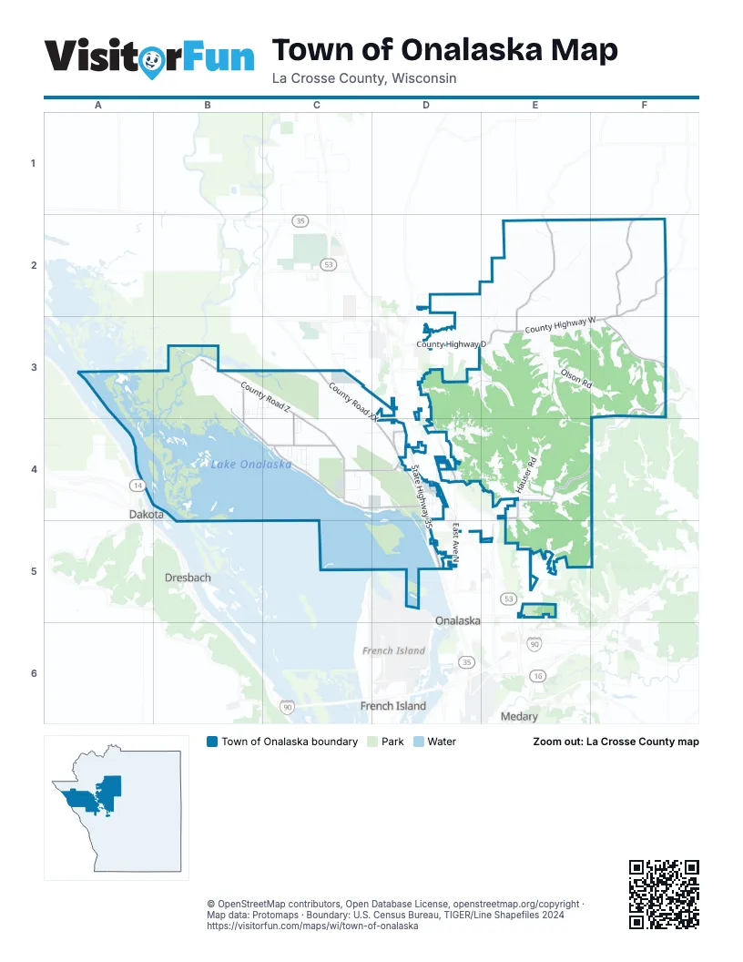
Street index of Town of Onalaska
Each street on the sheet and the grid squares it crosses.
- Keppel RoadD2
- Anderson RoadE2
- County Highway DE2, D3, E3
- Hossfeld RoadE2, D3, E3
- Knudson RoadE2, E3
- M Johnson RoadE2
- O Nelson RoadE2
- Skoug RoadE2
- Woodhollow RoadE2
- Bringe RoadF2
- County Highway MF2, F3
- County Highway WF2, E3, F3
- County Road WF2, F3
- Dokkebaken RoadF2, F3
- J O Johnson RoadF2, F3
- O L Olson RoadF2
- Sweden Coulee RoadF2
- County Road ZB3, C3, C4
- County Road ZBB3, B4, C4
- Desolation RowB3
- Dutton DriveB3
- Eric AvenueB3, B4
- Fairview StreetB3, C3
- Forest DriveB3, C3
- Homestead PlaceB3
- Jason StreetB3, C3, B4
- Lytle RoadB3
- Northshore DriveB3, B4, C4
- Prairie Pine LaneB3
- Rivertrail WayB3
- Rose LaneB3
- Sportsman Club RoadB3
- Tower StreetB3, C3
- Woodview DriveB3, B4
- Briggs RoadC3
- County Highway ZZC3, C4
- County Road XXC3, D3, D4
- Fox StreetC3, C4
- Maple DriveC3, C4
- Prairie DriveC3, C4
- Apple Valley RoadD3, D4
- Cole CourtD3
- Deerwood StreetD3
- Filler CourtD3, D4
- Forest View DriveD3
- Granum StreetD3
- Hidden Valley RoadD3
- Maplewood LaneD3, E3
- Oakwood CircleD3
- Red Oak GlenD3, D4
- Remus RoadD3, D4
- Riverview DriveD3, D4, E4
- Sand Lake RoadD3, D4, E5
- Summerglow TrailD3, D4
- Sun Valley DriveD3
- Three Party RoadD3
- Village View LaneD3
- Wildwood Valley CourtD3
- Wildwood Valley RoadD3, E3
- Willow Wood CourtD3
- Deichelbohrer RoadE3
- Forest CourtE3
- Freier RoadE3
- Glens PlaceE3, F3
- Johnson Coulee RoadE3, E4
- McCurdy PlaceE3
- McCurdy RoadE3, F3
- Olson RoadE3, F3
- Pinewood DriveE3
- Roberts RoadE3
- Ronnie RoadE3
- Valley PlaceE3
- A Miller RoadF3
- County Highway SF3, E4, F4
- Ed Severson RoadF3
- L Nelson RoadF3
- Shefelbine RoadF3
- Beacon StreetB4, C4
- Balduzzi DriveC4
- Bernard StreetC4
- Cottage LaneC4
- County Highway ZC4, D4
- County Road ZNC4, D4
- Dynamic WayC4
- Eagle Circle LaneC4
- Elm StreetC4
- Hawthorne StreetC4
- Huntington CourtC4
- Lake Park DriveC4
- Lakeview Court EastC4
- Lakeview Court WestC4
- Lark AvenueC4
- Mulder LaneC4
- Northshore LaneC4, D4
- Park StreetC4
- Paudler PlaceC4, D4
- Prairie LaneC4
- Rivendell CourtC4
- Robin StreetC4
- Schaller DriveC4
- Tabbert StreetC4
- Theron CourtC4
- 2nd StreetD4
- Abbey RoadD4
- Alpine WayD4
- Ann StreetD4
- Apache CourtD4
- Apple Blossom TrailD4
- Birchview DriveD4
- Carefree DriveD4
- Cass StreetD4
- Cheyenne DriveD4
- Circle Drive EastD4
- Circle Drive WestD4
- Cloverdale RoadD4
- Commerce RoadD4
- Cottonwood PlaceD4
- County Highway OTD4
- County Highway ZMD4
- County Road OTD4
- Evergreen WayD4
- Front StreetD4
- Frontage RoadD4
- Goose Pond CourtD4
- Grayhawk DriveD4
- Hanson RoadD4
- Haull StreetD4
- Hilltop DriveD4
- Holley DriveD4
- Industrial BoulevardD4
- Josie StreetD4
- Kylawn CourtD4
- La Crosse County LandfillD4
- Lake Forest DriveD4
- Lumber PlaceD4
- Meadow PlaceD4
- Michigan StreetD4
- Mohican TrailD4
- Navaho PassD4
- North CourtD4
- Oak Hills DriveD4
- Orchard LaneD4
- Park DriveD4
- Paula DriveD4
- Penney LaneD4
- Pertzsch DriveD4
- Pineview DriveD4
- Prairie Fire TrailD4
- Prairieview DriveD4
- Quarterdeck DriveD4
- Raptor RoadD4
- Reef RoadD4
- Sandpiper DriveD4
- Schilling RoadD4, E4
- Spruce StreetD4
- State Highway 35D4, D5
- Strawberry RoadD4
- Sugar LaneD4
- Sunset DriveD4
- Terrace DriveD4
- Trussoni CourtD4, E4
- Ulman StreetD4
- Walden CourtD4
- Walden PlaceD4
- Wendtland RoadD4, E4
- Westview DriveD4
- Winona CourtD4
- Woodland PassD4
- Abnet RoadE4
- Aspen RoadE4
- Bucklin RoadE4
- Clover CourtE4, E5
- Hauser RoadE4
- Kings RoadE4
- Koss RoadE4
- Krause RoadE4
- Kurt BoulevardE4
- Marco RoadE4, E5
- Moos RoadE4
- North Innsbruck RoadE4, F4, E5
- Oakwood DriveE4
- Risberg CourtE4, E5
- Riverview Drive EastE4
- Ruth LaneE4
- Rylla StreetE4
- Schultz LaneE4
- Sobkowiak RoadE4
- William DriveE4
- Winesap DriveE4
- East Avenue NorthD5
- Hurricane CourtD5
- Kramer RoadD5
- Lawrence PlaceD5
- Mason StreetD5
- Riders Club RoadD5
- Schnick RoadD5
- Stuhr CourtD5
- Sunset Vista RoadD5
- Aspenwood TrailE5, F5
- Clearwater DriveE5
- Clifford DriveE5
- East Main StreetE5
- Fair Meadow WayE5
- Green Coulee LaneE5
- Green Coulee RoadE5
- Innsbruck RoadE5, F5
- Shamrock LaneE5
- Superior StreetE5
Places on the map
- Apple Valley Bluff
- Asbury Cemetery
- Black Lotus Custom Tattoos & Body Piercing
- Brice Prairie
- Brice Prairie Bar & Grill
- Brice Prairie EMS
- Carlson Point
- Clearwater Cabins
- Cordell's Automotive Service & Tire
- Corto's Ona-Lakehouse Rental, LLC
- Coulee Golf Bowl
- Coulee Region Riders Club
- Emma's
- Empire Quarry
- Fred Funk Boat Landing
- Halfway Creek Cemetery
- Halfway Creek Lutheran Church
- Halfway School
- LaCrosse Country
- Lake Onalaska
- Luther College
- Lytle
- Maple Shade School
- Midway Railroad Prairie State Natural Area
- Mosey's Landing
- Red Pines Bar & Grill
- Relic Road
- Sandy Knolls Park
- Scandinavian Baptist Church Cemetery
- Schafer's Boat Livery
- Schafer's River Rentals
- Sugarloaf
- Swarthout Park
- Thunderbird Hills Park
- Visitor Center
- Weverstad Cemetary
Next to Town of Onalaska
- Dakota
- Dresbach
- French Island
- Medary
- Onalaska map
© OpenStreetMap contributors, Open Database License, openstreetmap.org/copyright · Map data: Protomaps · Boundary: U.S. Census Bureau, TIGER/Line Shapefiles 2024















