

Wyoming map
Park County map
About 31,082 people live here (Census Bureau, 2024 estimate). The sheet's index lists 300 streets; Grand Loop Road, Lane 11 H and North Fork Highway cross the most grid squares. Things to do inside the boundary: Buffalo Bill Center of the West, Cody Nite Rodeo and Grand Canyon of the Yellowstone.
Open the map (PDF, US Letter)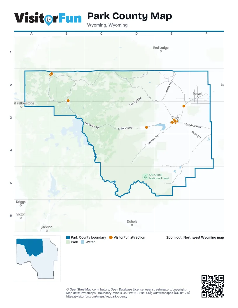
Street index of Park County
Each street on the sheet and the grid squares it crosses.
- North Fork HighwayC3, D3, E3
- Belfry HighwayE2, E3
- Greybull HighwayE3, F3
- Powell HighwayE3
- Medicine Wheel PassageF2
- Gallatin RoadA2
- Black and White RoadE2, E3
- Sheridan AvenueF2, E3
- Bighorn AvenueE3
- East Coulter AvenueF2
- Yellowstone AvenueE3
- 16th StreetE3
- West Coulter AvenueF2
- Main StreetF2, E3, F3
- West Yellowstone AvenueE3
- 17th StreetE3
- 8th StreetE3
- State StreetE4, F4
- Ash StreetF2, E3
- Depot DriveE3
- WY 114F2
- Grand Loop RoadA2, B2, A3, B3
- Chief Joseph HighwayD2, E2, E3
- Southfork RoadE3, D4, E4
- Northeast Entrance RoadB2, C2
- East Entrance RoadB3, C3
- Beartooth HighwayD2
- Pitchfork RoadE4, F4, E5
- Norris-Canyon RoadB2, B3
- Lane 13F3
- State Highway 295F2, F3
- Beartooth Scenic BywayC2, D2
- Southfork HighwayE3
- County Highway R18E2
- Badger Basin RoadE2, E3
- State Highway 294E2
- Beacon Hill RoadE3
- 11th StreetE3
- Temporary North Entrance RoadB2
- Stampede AvenueE3
- West Entrance RoadA3
- Roger Sedam DriveE3
- East South StreetF2
- Park AvenueE3, F4
- Albright AvenueB2
- South Bent StreetF2
- Parade Ground RoadB2
- Hayes AvenueF4
- South Fair StreetF2
- South Fork AvenueE3
- West South StreetF2
- North Entrance RoadB2
- Wood River RoadE4, E5
- Lower Greybull RoadF4
- Lane 10E2, F2
- Road 1AbE2
- Lane 11F2
- Road 8VeE2
- Road 2ABE3
- Canyon RoadE2
- Road 11F2, F3
- Road 8WcE2
- Road 9F2, F3
- Mountain View DriveE3
- 12th StreetE3
- Road 1 NorthF2
- Skyline DriveE3
- 19th StreetE3
- Beck AvenueE3
- North Absaroka StreetF2
- River View DriveE3
- 29th StreetE3
- Blackburn StreetE3
- 23rd StreetE3
- North Clark StreetF2
- East 3rd StreetF2
- Salsbury AvenueE3
- North Bent StreetF2
- Cody AvenueE3
- East 1st StreetF2
- South Absaroka StreetF2
- South Clark StreetF2
- Canyon AvenueE3
- Burlington Meeteetse HighwayF4
- Sunlight RoadD2, D3
- McCullough Peaks RoadE3, F3
- Lane 9E2, F2
- Road 3FkE3, F3, E4
- Stagecoach TrailD3, E3
- Road 7RpE2
- Carter Mountain Access RoadE4
- Road 3JUF3, F4
- Meeteetse Creek RoadE4, F4
- Lane 8E2, F2
- Little Sand Coulee RoadE2
- Rattlesnake Creek RoadD3, E3
- Monument Hill RoadE3
- Lane 7F2
- Road 7F2, F3
- Lane 11 HE2, F2, E3, F3
- Road 10F2, F3
- Road 4CpE5, F5
- Road 5WtE4, E5
- Lane 14E3, F3
- Clark AvenueE2, F2
- Road 5F2, F3
- Road 19E2, E3
- Sawmill RoadE5
- Lane 5F2
- Road 6F2, F3
- Road 20E2, E3
- Road 1AfE2
- Road 2F2, F3
- Spring Creek RoadE4
- Road 8F2, F3
- Blacktail Plateau DriveB2
- 1Vae RoadF2
- Diamond Basin RoadE3
- Road 3F2
- Road 4EuE4
- Road 1 X GF2
- Road 1VaF2
- Hunter Creek RoadD4
- Lane 13 HE3, F3
- 4Cp RoadE5
- Lane 8 HF2
- Half Moon RoadE4
- 60RE4
- Road 1XgF2
- Road 6NsE3, E4
- Bald Ridge Access RoadD2, E2
- Forest Service Road 202E5
- Road 1WawF2
- Lower Southfork RoadE3, E4
- Road 1OdF2
- Spirit Mountain RoadE3
- Road 2AbnE3
- Road 12F2
- Lane 6F2
- Road 1NGE2, F2
- Road 1BfE2
- Road XUXD2
- Road 2ABWE3
- Road 1VanF2
- North Tolman RoadE2
- Road 6BUD3
- Hoo Doo Ranch RoadE4
- Lane 12E3, F3
- Logan Mountain RoadE3
- Road 3NgF4
- Jim Mountain RoadD3
- Road 6RtE3
- Conoco RoadF2
- Bennet Creek RoadE2
- Road 5XsE5
- Road 8UcE2
- Lane 15E3, F3
- Squaw Teats RoadF5
- Road 3EmE4
- Lane 3F2
- Lane 16E3
- Road 4F2, F3
- Road 3SlF4
- Road 14F2, F3
- Road 6EhD4
- 3Cxs RoadE3
- Lane 10 HF2
- Lane 4F2
- Road 22E2, E3
- Road 5NF2
- Sage Creek RoadE3
- Big Sand Coulee RoadE2
- Road 3LdF4
- Lodgepole Creek RoadD2
- Forest Service Road 203E5
- Wood RiverE5
- Kirwin TrailE5
- Road 3DXE3
- Peterson Ranch RoadD2
- LP Oil Field RoadF2
- Road 17E2
- Forest Service Road 206E4, E5
- County Lane 40 1/2F4
- Road 7WcE3
- Road 16E2
- North Rim DriveB2
- Road 6PrE3, E4
- Cannonball TrailD3
- Big Horn AvenueF2, E3
- Old North Entrance RoadB2
- Road 21E2
- Carter View DriveE3
- Whit Creek RoadD3
- Chittenden Loop TrailB2
- Virginia Cascade DriveB2, B3
- Louis l'Amour LaneE2
- Little Rock RoadE2
- Road 3XqF4
- South Rim DriveB2, B3
- Road 6JmD4
- Stagecoach RoadB2
- Road 174D2
- Road 13F2, F3
- Sunset RimE3
- Hidden Valley RoadE3
- Bear Creek RoadE3, E4
- Upper Terrace DriveB2
- Canal RoadE2, F3
- Road 3CqE4
- Morgan RoadD3, E3
- Nielson RoadE4
- Stillwater DriveD3
- Lane 9 HF2
- Panther BoulevardF2
- Road 8 HF2
- The Way WestD2
- L 6F2
- L17 RoadE3
- Road 19 1/2E3
- Road 8RaE2
- Copperleaf DriveD3
- Boulder DriveD3
- Green Creek RoadD3
- Road 1SgF2
- Norquist Ranch RoadD2
- Mountain View StreetF2
- Lane 7HF2
- Jim Creek RoadD3
- Road 5RuE4
- E AvenueE3
- Sage DriveE3
- Marquette DriveE3
- Cliff DriveE4
- Road 1BhE2
- Arrow AvenueE3
- Chittenden RoadB2
- Jr StreetE3
- Yellow Knife TrailE2
- Cooper LaneE3
- Road R1F2
- Cloudy DriveD3
- Road 2FeE3
- Valley Ranch RoadD4
- Lane 1F2
- Road 1F2, F3
- Bartlett LaneE3
- West 7th StreetF2
- Dunn Creek RoadD3
- Road 2EEE3
- Elk RoadD3
- North Crandall RoadD2
- Wapiti Estates DriveD3
- South Tolman RoadE2
- Hawk DriveD3
- Lane 17E3
- Road 2AcE3
- Shining Mountain RoadE2
- Road 2BcE3
- Cody Landfill RoadE3
- Road 12 HF2, F3
- Appaloosa LaneE3
- Davis Draw RoadE4
- Meadow Lane AvenueE3
- Lane 18E3
- Road 6SrE3
- Beverly DriveE3
- Lane 7 HF2
- Forest Service Road 414D3
- Shirley DriveE4, F4
- North Division StreetF2
- Central AvenueE3
- Road XvwD2
- County Highway L17E3
- Wyoming AvenueF2, E3, F4
- Road 2DawE3
- Chance RoadE2
- Rolling Hills DriveE3
- Road 2BeE3
- L Bar T Ranch RoadD2
- Big Creek DriveD3
- Lane 6 HF2
- Panorama LaneE3
- Cemetery RoadF2
- Sun Burst DriveE3
- Derby Ranch RoadE2
- Schneider RoadE3
- Wapiti Heights DriveD3
- Road 3KdF4
- Road 2DAE3
- Forest Service Road 409D3
- Absaroka View DriveF4
- Road 22 HE2
- Cougar AvenueE3
- Eaglenest TrailE3
- Road 6NqE3, E4
- 26th StreetE3
- Canyon Lake DriveE3
- Road 6 MrE3
- Black Diamond DriveE4
- Powerhouse RoadB2
Things to do on the Park County map
- Buffalo Bill Center of the West
- Cody Nite Rodeo
- Grand Canyon of the Yellowstone
- Mammoth Hot Springs
- Yellowstone National Park
- Yellowstone Safari Company
- Cody Cattle Company
- Cody Trolley Tours
- East Yellowstone Valley
- Fireworks Factory Outlet
- Heart Mountain Interpretive Center
- Historic Cody Mural and Museum
- Old Trail Town
- Rocky Mountain Dance Theatre
- Wyoming River Trips
Places on the map
- Beartooth Lake
- Beauty Lake
- Beck Lake
- Becker Lake
- Buffalo Bill Reservoir
- Buffalo Bill State Park
- Camp Buffalo Bill
- Canyon Campground
- Chain Lakes
- Cody
- Cody Shooting Complex
- Deaver Reservoir
- Deep Lake
- Fantan Lake
- Fern Lake
- Fishing Bridge RV Park
- Frannie
- Gardner Lake
- Garland
- Granite Lake
- Grebe Lake
- Grizzly Lake
- Hector Knob
- High Lakes Wilderness Study Area
- Highline Trail Lakes
- Ice Lake
- Island Lake
- Ivy Lake
- Lake Reno
- Little Bear Lake
- Long Lake
- Lower Sunshine Reservoir
- McBride Lake
- McCullough Peaks Wilderness Study Area
- North Absaroka Wilderness
- Northwest College
- Powell Municipal Airport
- Shoshone National Forest
- Washakie Wilderness
- Yellowstone National Park
Next to Park County
- Driggs
- Dubois
- Jackson
- Red Lodge
- Victor
- West Yellowstone
© OpenStreetMap contributors, Open Database License, openstreetmap.org/copyright · Map data: Protomaps · Boundary: Who's On First (CC-BY 4.0); Quattroshapes (CC BY 2.0)















