

Alabama map
Birmingham map
About 196,357 people live here (Census Bureau, 2024 estimate). The sheet's index lists 300 streets; John M. Harbert III Freeway, 1st Avenue North and 2nd Avenue North cross the most grid squares. Things to do inside the boundary: 16th Street Baptist Church, Alabama Jazz Hall of Fame and Arlington Antebellum Home & Gardens.
Open the map (PDF, US Letter)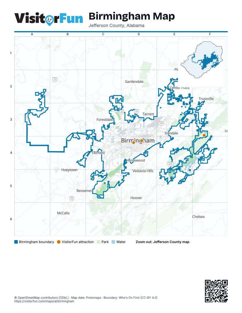
Street index of Birmingham
Each street on the sheet and the grid squares it crosses.
- John M. Harbert III FreewayF2, F3, E4, D5, E5
- Red Mountain ExpresswayC4, D4
- 1st Avenue NorthD3, E3, C4, D4, A5
- 1st Avenue SouthD3, E3, C4, D4
- 5th Avenue SouthD3, E3, C4, D4
- 4th Avenue SouthD3, E3, C4, D4
- 3rd Avenue SouthD3, E3, C4, D4
- Crestwood BoulevardF3, D4, E4
- Pinson Valley ParkwayE1, D2, E2
- 2nd Avenue NorthD3, E3, C4, D4, A5
- Gadsden HighwayF2, E3, F3
- 3rd Avenue NorthD3, E3, C4, D4
- Parkway EastE2, E3
- Finley BoulevardC3, C4
- 4th Avenue NorthD3, E3, C4
- Bessemer RoadB4, C4, B5
- Decatur HighwayC3
- Vanderbilt RoadD3, D4
- Carraway BoulevardC3, C4, D4
- 24th Street NorthC3, C4
- Bankhead Highway WestB3, C3, C4
- Arkadelphia RoadC4
- United States Highway 280D5, E5
- Edwards Lake RoadE2, F2
- 34th Street NorthC3, D3, D4
- Center Point ParkwayE1, E2
- 35th Street NorthC3, D3, D4
- 4th Street WestC3, C4
- 3rd Avenue WestC4
- Forestdale BoulevardB3
- 12th Street NorthC3, C4
- Bessemer Super HighwayB5
- 3rd Street WestC3, C4
- 7th Street WestC4
- 13th Street NorthC3, C4
- 5th Street WestC3, C4
- 24th Street SouthC4, D4
- 11th Street NorthC4
- Roebuck ParkwayE3
- Tallapoosa StreetD3
- 4th Place WestC3, C4
- 9th Street NorthC4
- 35th Street SouthD4
- 8th Street WestC4
- 64th Street SouthD3, D4
- 2nd Place WestC3, C4
- 36th Street SouthD4
- Parkway Drive SouthwestF3
- 3rd Place WestC4
- 10th Street NorthC4
- 3rd Court SouthD3, D4
- 64th Street NorthD3
- Resource Center ParkwayE6
- Key DriveE5, E6
- Lakeshore ParkwayB5, C5, B6
- Birmingport RoadA3, A4, B4
- 6th Avenue SouthD3, E3, C4, D4
- Messer Airport HighwayD3, D4
- Jefferson Avenue SouthwestC4, B5, C5
- Coalburg RoadC2, C3
- 10th Avenue SouthE3, C4, D4
- 5th Avenue NorthD3, E3, C4, D4
- F. L. Shuttlesworth DriveC3, D3, C4
- Montclair RoadD4, E4
- 6th Avenue NorthD3, E3, C4, D4
- 7th Avenue NorthD3, E3, C4, D4
- Richard Arrington Jr Boulevard NorthD3, C4, D4
- Cahaba Valley RoadE5, F5, E6
- Oporto-Madrid Boulevard SouthD3, E3, E4
- John Rogers DriveE3, F3
- University BoulevardC4, D4
- Daniel Payne DriveB3, C3
- Avenue IB4, B5
- West Lakeshore ParkwayC5
- 18th Street NorthC3, C4
- Grants Mill RoadF4, F5
- Avenue WB4
- 22nd Street NorthC3, C4
- 25th Street NorthC3, C4
- Reverend Abraham Woods Jr BoulevardC4, D4
- 19th Street NorthC3, C4
- Carson RoadE1, E2
- 20th Street NorthC3, C4
- Montevallo RoadD4, E4, C5
- 20th Street EnsleyB4
- Lomb AvenueB4, C4
- Avenue VB4
- Huffman RoadE2
- 8th Avenue WestC4
- Richard Arrington Jr Boulevard SouthC4, D4
- Eastern Valley RoadF4, F5
- Green Springs Highway SouthC4, C5
- Graymont Avenue WestC4
- West Oxmoor RoadC5, C6
- 21st Street EnsleyB4, C4
- Dugan AvenueB3, B4
- 22nd Street SouthC4, D4
- Dennison Avenue SouthwestC5
- Cahaba River RoadD5, E5, E6
- Tarrant Huffman RoadD3, E3
- Ensley 5 Points West AvenueB4
- Springville RoadE2
- 20th Street SouthC4, D4
- 19th Street EnsleyB4
- Cleburn Avenue SouthwestC4, B5, C5
- Green Springs Avenue SouthC4, C5
- Palisades BoulevardC5
- Derby ParkwayF3
- 21st Avenue SouthC4, D4, C5
- Alemeda Avenue SouthwestC4, B5, C5
- Montevallo Road SouthwestC4, C5
- Bush BoulevardB4, C4
- Adamsville Ensley RoadB3, B4
- Martin Luther King Jr DriveC4, C5
- Valley RoadE3, B4
- 5th Court NorthD3, E3, C4, D4
- 32nd Street SouthD4
- Red Lane RoadE3
- Bush Boulevard WestC4
- Green Springs HighwayC4, C5
- Daniel Payne Drive WestC3
- Graymont Avenue NorthC4
- Valley AvenueD4, C5
- Milan ParkwayB5
- Oxmoor RoadC5
- 13th Avenue NorthwestE2
- 4th Street SouthwestC4
- 6th Avenue SouthwestC4
- Palisades DriveC5
- Brighton RoadB5
- I-59 Access RoadB4
- Green Springs Avenue SouthwestC5
- I-20 Frontage RoadE4
- Washington Avenue SouthwestC4
- Country Club Road SouthD4
- Oporto-Madrid Boulevard NorthD3
- Pawnee Avenue SouthD4
- 96th Street NorthE3
- 7th Street SouthwestC4
- 26th Street SouthD4
- Niazuma Avenue SouthD4
- Princeton ParkwayC4
- 21st Street SouthD4, B5
- Barber CourtC5
- Madrid AvenueE3
- 77th Street NorthD3
- Allison-Bonnett Memorial DriveA5
- Princeton Parkway WestC4
- Jefferson AvenueB5
- Princeton Parkway SouthwestC4
- Woodward RoadB5
- Carson Road NorthwestE2
- 2nd Avenue SouthD3, E3, C4, D4
- 7th Avenue SouthE3, C4, D4
- Clairmont Avenue SouthD4
- East Lake BoulevardD3
- Highland AvenueE3, D4
- 12th Avenue NorthD3, C4, D4
- Rex Lake RoadF4
- 9th Avenue NorthD2, D3, C4, D4
- 16th Street NorthC3, C4
- 35th Avenue NorthC3, D3
- 29th Street NorthC3, C4, D4
- 11th Avenue SouthC4, D4
- 11th Avenue NorthD3, C4, D4
- 15th Avenue NorthC3, D3, C4
- Wenonah Oxmoor RoadB5, C5
- Avenue FB4
- Avenue EastB4
- Avenue UB3, B4
- 16th Avenue SouthE3, C4, D4
- Alton RoadE3, F3
- Lawson RoadD2, E2
- 28th Street NorthC3, C4, D4
- Wenonah Road SouthwestB5, C5
- Georgia RoadD3, E3
- Tin Mill RoadA4, B4, A5
- 17th Street NorthC3, C4
- 9th Avenue SouthE3, C4, D4
- Pike RoadB4, C4
- Center Street NorthC3, C4
- 40th Street NorthD3, D4
- 31st Street NorthC3, C4, D4
- 27th Street NorthC3, C4
- 10th Avenue NorthD3, C4
- Pearson Avenue SouthwestC4, B5
- Sicard Hollow RoadF4, E5
- Lexington StreetB4
- 18th Street SouthwestC4, C5
- Colonnade ParkwayD5, E5
- Warrior RoadB4
- 27th Avenue NorthC3, D3
- 68th Street NorthD3
- 32nd Avenue NorthC3, D3
- 41st Avenue NorthC3, D3
- 17th Street SouthwestC4, C5
- 23rd Street NorthC3, C4
- 30th Street NorthC3, C4, D4
- Tuscaloosa AvenueC4
- Pratt HighwayB3, B4
- Westchester DriveE1
- 47th Avenue NorthC3, D3
- 31st Avenue NorthC3, D3
- Cotton Avenue SouthwestC4
- Roebuck DriveE2, E3
- Cherry AvenueB3, B4
- 12th Avenue SouthE3, C4, D4
- Five Mile RoadE2
- 2nd StreetB4, C4, A5
- O AvenueB4, B5
- Old Mulga Loop RoadA3, A4
- 25th StreetB4, C4
- 32nd Street NorthC3, C4, D4
- 19th Street SouthC4, D4
- Summit BoulevardD5
- 21st Street SouthwestB4, B5
- Ensley Pleasant Grove RoadA4, B4
- 5th Street NorthC4
- Brook Highland ParkwayE5, E6
- Valley Crest DriveD2, E2
- 14th Street SouthC4
- Sunhill Road NorthwestE1, E2
- 14th Avenue SouthC4, D4
- 24th Street SouthwestB5
- 13th Street SouthC4
- Pleasant Grove RoadA4, A5
- Shannon Wenonah RoadB5, B6
- Airport RoadD2, D3
- 23rd Street SouthC4, D4
- Woodland Avenue SouthwestB4, C4
- 31st Street SouthwestB5
- 6th Street NorthwestE1, E2
- 48th StreetB4, B5
- Shannon RoadB6
- 35th StreetB4
- 15th Street NorthC3, C4
- Goldwire Street SouthwestC4, C5
- 18th Street SouthC4, D4
- Center Street SouthC4, C5
- Sheridan RoadB3, B4
- Wilson Road SouthwestB5
- 52nd Street SouthD4
- Avenue KB4, B5
- Avenue MB4, B5
- 7th AvenueE3, B4
- 14th Street SouthwestC4, C5
- Lewisburg RoadC3
- Spaulding Ishkooda RoadC5
- 56th Street SouthD3, D4
- 16th Street SouthC4
- Shannon Oxmoor RoadC5, C6
- Ruffner RoadE3
- Zion City RoadD2, D3
- 65th Street NorthD3
- 12th Street SouthC4
- Rugby AvenueE3
- 1st Street SouthC4, A5, C5
- Pine Tree DriveE2
- Park PlaceE2, C4
- 8th AvenueB4
- Amber Hills RoadF3
- Red Mill RoadE2
- 29th Street SouthD4
- West BoulevardE3
- Cahaba RoadD4
- Aviation AvenueD3
- Altamont RoadD4
- 1st StreetF3, B4, C4, A5, C6
- 57th StreetB4, B5
- Vinesville RoadB5
- Erie StreetB4
- 14th Street NorthC3, C4
- 86th Street SouthE3
- 85th Street SouthE3
- 9th AvenueB4
- Main StreetE3, F3
- 38th Street SouthD4
- Beacon Parkway WestC5
- 17th Street SouthC4
- New Mulga Loop RoadA3, A4, B4
- Overton RoadE4
- Carline AvenueB4, B5
- 12th Court NorthD3, C4
- 15th Street SouthC4
- Mulga Loop RoadA3, B3, B4
- Shades Crest RoadC6
- 40th StreetD3, B4
- Ishkooda Road SouthwestB5, C5
- Shady Grove RoadC2
- Venice RoadB5
- 10th AvenueB4
- Cairo AvenueB5
- 83rd Street SouthE3
- Republic RoadB2
- 68th Street SouthD3, E3
- 58th Street SouthD4
- 27th Street SouthD4
- Queenstown RoadF3
- 4th Place NorthC4
- Beacon Parkway EastC4, C5
Things to do on the Birmingham map
- 16th Street Baptist Church
- Alabama Jazz Hall of Fame
- Arlington Antebellum Home & Gardens
- Barber Vintage Motorsports Museum
- Birmingham Civil Rights Institute
- Birmingham Civil Rights National Monument
- Birmingham Museum of Art
- Birmingham Zoo
- McWane Science Center
- Sloss Furnaces
- Southern Museum of Flight
- The Summit
- Vulcan Park & Museum
Places on the map
- Altamont Park
- Avondale Park
- Barber Motorsports Park
- Barber Motorsports Parkway
- Birmingham Botanical Gardens
- Birmingham Eastern Landfill
- Birmingham Zoo
- Birmingham-Shuttlesworth International Airport
- Central City
- City Walk BHAM
- Colonnade
- Cooper Green Park
- Crestwood Festival Center
- East Lake
- East Lake Park
- East Thomas Yard
- Elmwood Cemetery
- Ensley Park
- FedEx
- Flora Johnston Nature Park
- Flora Johnston Trail
- Forest Hill Cemetery
- George Ward Park
- Goat Island
- Grace Hill Cemetery
- Grandview Medical Center
- Greenwood Park
- Highland Park Golf Course
- Huffman High School
- Kart/Motocross
- Lake Purdy
- McLendon Park
- Red Mountain Park
- RTJ Oxmoor Valley Golf
- Ruffner Mountain
- The Summit
- Vulcan Trail
- Wade Sand & Gravel
Next to Birmingham
- Bessemer
- Brookside
- Cahaba Heights
- Center Point
- Edgewater
- Fairfield
- Forestdale
- Gardendale
- Graysville
- Homewood
- Hoover map
- Hueytown
- Irondale
- McDonald Chapel
- Mountain Brook
- Mulga
- Pinson
- Tarrant
- Trussville
- Vestavia Hills
© OpenStreetMap contributors, Open Database License, openstreetmap.org/copyright · Map data: Protomaps · Boundary: Who's On First (CC-BY 4.0); Quattroshapes (CC BY 2.0)