

Arkansas map
North Little Rock map
About 64,498 people live here (Census Bureau, 2024 estimate). The sheet's index lists 300 streets; I-40 Frontage Road, Crystal Hill Road and Maumelle Boulevard cross the most grid squares. Also on it: ADESA Little Rock, Arkansas Surgical Hospital and Baptist Health Medical Center - North Little Rock.
Open the map (PDF, US Letter)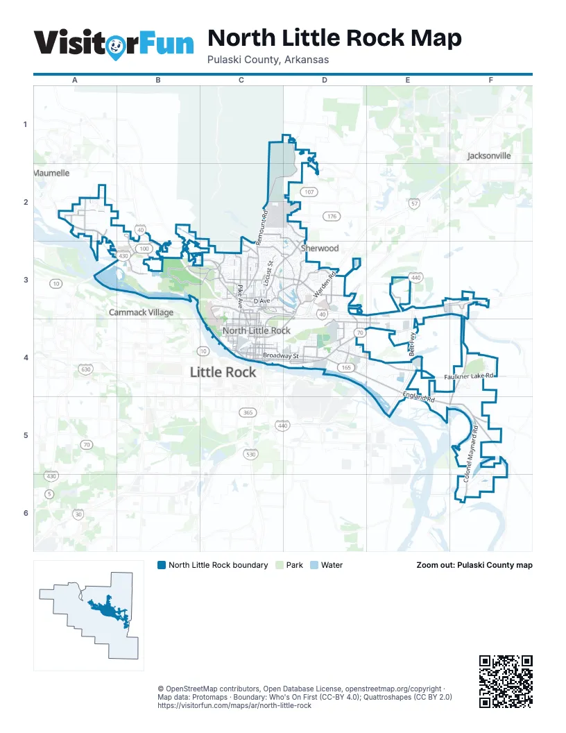
Street index of North Little Rock
Each street on the sheet and the grid squares it crosses.
- East Belt FreewayE4, E5
- North Belt FreewayE3, E4
- Crystal Hill RoadA2, A3, B3
- Maumelle BoulevardA2, A3, B3
- East Broadway StreetC4, D4
- John F. Kennedy BoulevardD2, C3, D3
- Colonel Maynard RoadF5, F6
- England RoadE4, E5, F5
- Pike AvenueC3, C4
- McCain BoulevardC3, D3
- East McCain BoulevardC3, D3
- Old England HighwayD4, F5
- Mac Arthur DriveC3
- Riverfront DriveC4
- MacArthur DriveB3, C3
- Baucum PikeD4, E4
- Brother Paul DriveC4, D4
- West Riverfront DriveC4
- West Broadway StreetC4
- North Broadway StreetC4
- Fairfax DriveD3
- North Hills BoulevardD2, D3, C4
- Faulkner Lake RoadE4, F4
- Camp Robinson RoadC2, C3
- North Locust StreetC3, C4
- North Main StreetC3, C4
- West Pershing BoulevardC3
- North Maple StreetC3, C4
- North Cypress StreetC3, C4
- Clubhouse at Stone Links North Little Rock ArkansasF4, F5
- Valentine RoadF3, F4
- Lynch DriveD4, E4
- Warden RoadD3
- West 16th StreetC4
- Randolph RoadC3, D3
- Counts Massie RoadA2
- West 18th StreetC4
- Bishop Lindsey AvenueC4
- West 47th StreetC3
- I-40 Frontage RoadC3, D3, C4, D4
- Jacksonville HighwayD3, D4
- Calvary RoadC3, D3
- Percy Machin DriveC3, C4
- Landers RoadD3
- Jacksonville BoulevardD3, C4, D4
- East 19th StreetC4, D4
- East 13th StreetC4
- White Oak CrossingA2
- Sa Jones DriveC4
- Springhill DriveD3
- Dick Jeter RoadF3
- Burks AvenueC3
- West 7th StreetC4
- State Highway 161D3
- West 37th StreetC3
- West 33rd StreetC3
- Frontage RoadD3
- US Hwy 67 Access RoadD3
- Doyle Venable DriveC3
- I-30 Frontage RoadC4
- Commerce CoveA2
- Lake View RoadD3
- Barbara DriveD3
- Riverfront PlaceC4
- South Cypress StreetC4
- East Pershing BoulevardC3
- Batesville PikeD1, C2, D2
- East Washington AvenueC4, D4
- Arlene Layman DriveB3, C3
- Division StreetC3, C4
- North Magnolia StreetC3, C4
- Allen StreetC3, C4
- Skyline DriveC3, D3
- Fairway AvenueC3, D3
- Paul Eells DriveA2
- North Poplar StreetC3, C4
- Eanes RoadE3, E4
- Parkway DriveC3
- Remount RoadC2, C3
- Maybelline RoadE3, F3
- West Bethany RoadD4
- Kierre DriveC3, D3
- North Willow StreetC3, C4
- River RoadC4
- Sycamore StreetC3, C4
- East Valentine RoadF3
- Bridgeway RoadB2, B3
- Northshore DriveB3
- Osage DriveC2, D2, D3
- Smokey LaneD3
- West Military DriveC3
- Crutcher StreetC3, C4
- West Maryland AvenueC2, D2
- West 19th StreetC4
- Waterside DriveC3, D3
- Joe Poch RoadB3, C3
- West 22nd StreetC4
- West 13th StreetC4
- West 35th StreetC3
- North Orange StreetC3
- Funland DriveB3, C3
- Dixie StreetD4
- Mission RoadC2
- East Bethany RoadD4, E4
- North Beech StreetC4
- Mills StreetD4
- Diamond DriveF3
- Lincoln AvenueD4
- Cherry Hill DriveC3
- East 15th StreetC4
- Old Highway 30F5
- West 4th StreetC4
- Kellogg Acres RoadD1, D2
- Idlewild AvenueC3
- Arkansas AvenueC2, D4
- 1st StreetC3, C4
- Edmonds StreetD4
- Somers AvenueD3
- East Military DriveC3
- West D AvenueC3
- Foxboro DriveC3
- West 9th StreetC4
- West F AvenueC3
- White Oak DriveB3
- Eureka Garden RoadE3, E4
- Rockwater BoulevardC4
- Charles H Boyer DriveC3
- Sam Evans DriveD4
- Donovan Briley BoulevardC3
- Texas AvenueC3
- Lindenhurst DriveC3
- Avondale RoadC3
- East Lincoln AvenueD4
- Dewafelbaker LaneA2, A3
- West 29th StreetC3
- North Buckeye StreetD4
- West 10th StreetC4
- Landski DriveC3
- Range Line AvenueD4
- Vestal BoulevardA2
- Ira StreetD4
- North Smothers StreetC4
- West Lee AvenueD2
- Crestview DriveC3
- A AvenueC3
- Lakewood DriveD3
- Richardson DriveA2
- Glenview LaneD4
- North Redwood StreetD4
- Park DriveC4
- East D AvenueC3
- Indian Hills DriveD2, D3
- Roundtop DriveD3
- West Kiehl AvenueD2
- South Locust StreetC4
- South Redwood StreetD4
- South Buckeye StreetD4
- Maple StreetC4
- Short Main StreetC3
- Miller RoadD2
- Military RoadC3
- Lakeview RoadC3, D3
- East 2nd StreetC4, D4
- Parker StreetC3, C4
- Tournament DriveB3
- Smarty Jones DriveF5, F6
- North Olive StreetC3, C4
- Marion StreetC3, C4
- Wilcox RoadF5, F6
- North Vine StreetC3, C4
- Schaer StreetC3, C4
- Glenmere RoadC3, D3
- Chandler StreetC3, C4
- East 5th StreetC4, D4
- Willow Beach RoadE5, F5
- East 4th StreetC4, D4
- Lakeshore DriveC3, D3
- North Pine StreetC3, C4
- West Scenic DriveC3
- Lochridge RoadC3, D3
- Silverwood TrailC2, C3
- Pontiac DriveD2, D3
- Ridge RoadC3
- North Cedar StreetC3, C4
- Crestwood RoadC3, D3
- Orange StreetC4
- Fort Roots DriveC4
- Frank StreetC3, C4
- West 15th StreetC4
- West 58th StreetC3
- Sunset DriveB3, C3
- West 20th StreetC4
- Franklin StreetC3, C4
- West 36th StreetC3
- Young RoadB3, D4
- Industry DriveE4
- Bay Oaks DriveC3
- West 21st StreetC4
- McCain Park DriveD3
- Flint Rock RoadC2, D2, C3
- Moss StreetC3, C4
- West 38th StreetC3
- Calico Creek DriveD3
- Healy StreetD4
- Saunders DriveD4, E4
- Water StreetD4
- Faulkner Crossing DriveF4
- Aztec DriveD2
- Rose LaneD4
- Toltec DriveD2
- West Long 17th StreetC4
- West B AvenueC3
- Bunker Hill DriveD3
- East 10th StreetC4, D4
- Edgemere StreetC3
- West 55th StreetC3
- East 8th StreetC4, D4
- North Gum StreetC3, C4
- East 16th StreetC4
- East 17th StreetC4
- Atkins StreetD4
- Nicole DriveC3
- Heritage Park CircleD3
- Bayou RoadB2, F6
- West Short 17th StreetC4
- North Palm StreetD4
- West 44th StreetC3
- Central Airport RoadE3, E4
- Alpha StreetD4
- West 52nd StreetC3
- Cedar StreetC3
- West 51st StreetC3
- North Walnut RoadC3
- Secretariat DriveF5, F6
- West 8th StreetC4
- Nannette StreetC3, C4
- East 14th StreetC4
- Campbell RoadD4, E4
- Prospect TrailB3
- Cedar Creek RoadD3
- Greenway DriveD3
- East 6th StreetC4
- Rogers StreetD4
- Garland AvenueC3, D3
- Arlington DriveD3
- Lynn LaneC3
- Augusta StreetC3, C4
- Allwood DriveC3
- Gregory StreetC4, D4
- North Hickory StreetC4
- West DriveC3, C4
- West 24th StreetC3
- East 12th StreetC4
- Lakewood Village DriveD3
- East Spriggs RoadC2
- Southwind DriveB3
- Cook's Landing RoadB3
- Richards RoadD3
- Championship DriveB3, C3
- West 23rd StreetC3
- West 17th StreetC4
- Veteran's HospitalC4
- East H AvenueC3
- West 34th StreetC3
- Citation DriveF6
- East 18th StreetC4
- Shamrock DriveC3
- Graham AvenueD4
- Desoto CircleD3
- Goshen AvenueC3
- Middle StreetD4
- Parkdale StreetD4
- Francis StreetC3
- West M AvenueC3
- Chimney Rock DriveD3
- West 50th StreetC3
- Gribble StreetD4
- Stone Links DriveF4
- North DriveC3, C4
- Crysyal Bay CircleA2
- Sierra Madre DriveC3
- Memorial DriveC3, C4
- Westwind DriveB2, B3
- Steel Bend RoadF6
- West 25th StreetC3
- Mine RoadD1, D2
- School StreetD4
- Flora StreetC3, C4
- War Eagle DriveD2
- Haywood StreetD4
- West A AvenueC3
- Denton RoadD2
- Kim DriveA2
- Foothills ApartmentsD3
- Arrowhead RoadC3
- Seminole TrailD3
- Collins Industrial PlaceA2
- Navajo TrailD3
- West 41st StreetC3
- Oakridge RoadD2
Places on the map
- ADESA Little Rock
- Arkansas Surgical Hospital
- Baptist Health Medical Center - North Little Rock
- Baucum Cemetery
- Big Rock Mountain
- Big Rock Quarry Park
- Burns Park
- Burns Park - RV Campground
- Burns Park Golf Course
- Campbell Lake Park
- Central Arkansas Christian High School
- Conley Park
- Cooks Landing Park
- Dickey-Stephens Park
- Downtown Riverside RV Park
- Edgewood Cemetery
- Emerald Park
- Eugene J. Towbin Healthcare Center;VA Medical Center
- Green Loop Trail
- Lakewood Lake Number One
- Lakewood Lake Number Six
- Lakewood Lake Number Three
- Lakewood Lake Number Two
- Lakewood Sports Complex
- Little Indian Lake Number One
- Little Indian Lake Number Two
- Love's Travel Stop
- Matthews Lake
- McCain Mall
- McConnell Lake Dam
- North Little Rock Municipal Airport
- Petro Stopping Centers
- Pfeifer Loop Trail
- Pilot Travel Center
- Red Hill
- Red Loop Trail
- Riverfront Park
- The Other Center
- Wild River Country
- Willow Beach Lake
Next to North Little Rock
- Cammack Village
- Jacksonville
- Little Rock map
- Maumelle
- Sherwood
© OpenStreetMap contributors, Open Database License, openstreetmap.org/copyright · Map data: Protomaps · Boundary: Who's On First (CC-BY 4.0); Quattroshapes (CC BY 2.0)