

Arkansas map
Little Rock map
About 204,774 people live here (Census Bureau, 2024 estimate). The sheet's index lists 300 streets; Cantrell Road, I-30 Frontage Road and Chenal Parkway cross the most grid squares. Things to do inside the boundary: Arkansas Museum of Fine Arts, Little Rock Central High School National Historic Site and Little Rock National Cemetery.
Open the map (PDF, US Letter)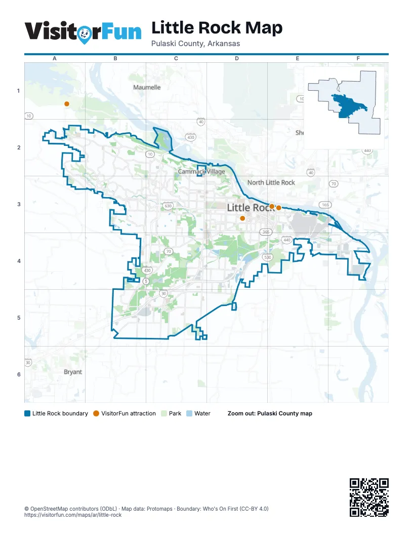
Street index of Little Rock
Each street on the sheet and the grid squares it crosses.
- Wilbur D. Mills FreewayC3, D3, E3
- East Belt FreewayD4, E4, F4
- Financial Centre ParkwayC3
- Cantrell RoadA2, B2, C2, C3, D3
- Chenal ParkwayA2, B2, B3, C3
- Stagecoach RoadB4, C4, B5
- East Roosevelt RoadD3, E3, E4, F4
- Colonel Glenn RoadB4, C4
- West Roosevelt RoadD3
- Asher AvenueD3, C4, D4
- South Broadway StreetD3, D4
- Frontage RoadE3, C4, E4
- La Harpe BoulevardD3, E3
- Scott StreetD3, E3, D4
- Cumberland StreetE3
- East Capitol AvenueE3
- Hermitage RoadB3, C3
- Sherman StreetE3, E4
- South Cumberland StreetE3, D4, E4
- North Broadway StreetD3
- West 11th Street SouthD3
- West 11th Street NorthD3
- East 11th Street SouthD3, E3
- I-30 Frontage RoadE3, C4, D4, B5, C5
- South University AvenueC3, C4, C5
- West Markham StreetB3, C3, D3, E3
- Mabelvale PikeC4, D4, C5
- Baseline RoadC5, D5
- Kanis RoadB3, C3
- Geyer Springs RoadC4, C5
- South Shackleford RoadC3, C4
- Rahling RoadB2, B3
- West 12th StreetC3, D3
- North Rodney Parham RoadC2, C3
- Arch StreetD3, D4, D5
- West 10th StreetC3, D3
- West 65th StreetC4, D4
- Chicot RoadC4, C5
- West 7th StreetD3, E3
- South Bowman RoadB3, C3, B4
- South Chester StreetD3, D4
- North University AvenueC2, C3
- Hinson RoadB2, B3, C3
- John Barrow RoadC3, C4
- West 11th StreetD3
- East 9th StreetD3, E3
- Lindsey RoadE4, F4
- West 17th StreetC3, D3
- Fair Park BoulevardD3, D4
- West 3rd StreetC3, D3, E3
- East 6th StreetE3
- West Baseline RoadB4, B5, C5
- Dr Martin Luther King DriveD3, D4
- West Capitol AvenueC3, D3, E3
- West 8th StreetD3
- South Main StreetD3, E3, D4
- South Izard StreetD3, D4
- Springer BoulevardE3, E4
- Young RoadC4, D4
- West 2nd StreetD3, E3, C5
- Mann RoadC5
- South Woodrow StreetD3, D4
- South Cedar StreetD3, D4
- South Pine StreetD3
- Reservoir RoadC2, C3
- Wright AvenueD3
- East 17th StreetD3, E3
- Taylor Loop RoadB2
- North Shackleford RoadC3
- South Arch StreetD3, D4
- Jones StreetD3, E4
- Mabelvale West RoadB5, C5
- Airport RoadE3, E4
- Napa Valley DriveB3, C3
- South Rodney Parham RoadC3
- East 4th StreetE3, B5
- Chenonceau BoulevardA2, B2
- East 8th StreetD3, E3
- Temple StreetE3
- East 3rd StreetE3
- East 11th StreetD3, E3
- Barber StreetE3, E4
- Interstate DriveD4
- East 2nd StreetE3, C5
- North Mississippi StreetC3
- West 9th StreetD3
- Otter Creek RoadB5
- College StreetE3
- East 12th StreetD3, E3
- Forbing RoadC4
- 3 M RoadE4
- South Victory StreetD3
- Lamar StreetD3
- South Mississippi StreetC3
- UAMS BoulevardD3
- Collins StreetE3
- Mabievale PikeC4
- Bankhead DriveE4
- North Mississippi AvenueC3
- Mabelvale Main StreetC5
- State Highway 300A2
- North Main StreetE3
- Picron StreetE3
- North Bowman RoadB3, C3
- West 10th Street NorthD3
- Wright Ave BypassD3
- Boone StreetD3
- North Alexander RoadB5
- Rector StreetE3
- East Markham StreetE3
- AR 365E4
- North Chester StreetD3
- Chenal Valley DriveA2, B2, A3, B3
- Frazier PikeE4, F4
- Rebsamen Park RoadC2, D2, D3
- Kavanaugh BoulevardC3, D3
- West 36th StreetB4, C4, D4
- Alexander RoadB5, C5
- West 22nd StreetC3, D3
- West Charles Bussey AvenueC3, D3
- West 13th StreetC3, D3
- West 18th StreetC3, D3
- Fourche Dam PikeE3, F3, E4, F4
- West 28th StreetC3, D3, D4
- West 19th StreetC3, D3
- Pleasant Valley DriveC2
- Scott Hamilton DriveD4, D5
- West 15th StreetD3
- David O Dodd RoadB4, C4
- Riverfront DriveD3
- West 33rd StreetC4, D4
- Mabelvale Cut Off RoadC5
- South Cross StreetD3, D4
- West 29th StreetC3, D3, D4
- West 6th StreetC3, D3, E3
- Evergreen DriveC3, D3
- South Battery StreetD3, D4
- Sardis RoadC5
- South State StreetD3, D4
- South Gaines StreetD3, D4
- Center StreetD3, D4
- South Louisiana StreetD3, D4
- Breckenridge DriveC2, C3
- Lee AvenueC3, D3
- Lamarche DriveB2
- South Ringo StreetD3, D4
- Vimy Ridge RoadB5
- H StreetC3, D3
- West Daisy L Gatson Bates DriveD3
- Marshall StreetD3, D4
- Kirk RoadB3
- Heinke RoadC5
- Pebble Beach DriveB2
- Bond StreetE3, E4
- St Charles BoulevardB3, C3
- Denny RoadA2, A3
- Woodlands TrailB3
- Pleasant Forest DriveB2, C2
- West 4th StreetD3, E3
- Washington StreetD3, D4
- Wellington Hills RoadB3
- Walker StreetC3, C4
- South Harrison StreetD3, D4
- South Monroe StreetD3, D4
- Peyton StreetD3
- Lancaster RoadD4
- Rock StreetE3
- North Hughes StreetC3
- Loyola DriveB3
- Wellington Village RoadB3
- Chalamont DriveA2
- Wimbledon LoopB5
- Otter Creek ParkwayB5
- Green Mountain DriveC3
- Old Forge DriveC3
- Pleasant Hill RoadB5
- Crystal Valley RoadB4
- East 15th StreetD3, E3
- Commerce StreetE3
- Pinnacle Valley RoadB2
- South Loop RoadC5
- Capitol Hill BoulevardB3
- Colonel Miller RoadB4, B5
- Industrial Harbor DriveF4
- Hindman Park WayC4
- Thibault RoadF4
- Peach Tree DriveC3
- Champagnolle DriveB3
- South Jackson StreetD3
- Potter StreetC3, C4
- East 21st StreetD3, E3
- South Hughes StreetC3
- North Van Buren StreetD3
- Leawood BoulevardC3
- Stanton RoadD4, D5
- Cooper Orbit RoadB3
- Jonesboro DriveD3
- Gum Springs RoadD4
- Bragg StreetE3
- Patterson RoadD4
- Mara Lynn RoadC3
- Sienna Lake DriveB4
- Kirby RoadB3
- Atkins RoadB3
- Kellett RoadE3, F3
- Parkway Place DriveB3
- Treasure Hill RoadC3
- Mabelvale Plaza DriveC4, C5
- Merrill DriveC3
- Dave Grundfest RoadE3, E4
- Brodie Creek TrailB3
- McAlmont StreetE3, E4
- North Cedar StreetD3
- North Pine StreetD3
- Woodland Heights RoadC2
- Northfield DriveA2
- Autumn RoadC3
- President Clinton AvenueE3
- Arkansas Valley DriveC2, C3
- Fletcher StreetE3
- St. Vincent WayB3
- East Daisy L Gatson Bates DriveD3, E3
- Arkansas Systems DriveB3
- Mabelvale Plaza LaneC5
- Keightly DriveC2, C3
- East 13th StreetD3, E3
- Portsmouth DriveD4
- Carolina DriveC4
- East 31st StreetD4, E4
- Arcade DriveC3
- Woodlane StreetD3
- Father Tribou StreetC3
- Technology DriveB3
- World AvenueE3
- Saint Charles BoulevardB3
- Old Cantrell RoadD3
- West 53rd StreetC4
- Shall AvenueE3
- Rushmore AvenueB3
- Founders DriveB3
- Lawson RoadB4
- James R. Rodgers Sr DriveE4
- Green RoadC5
- Mablevale Plaza BoulevardC5
- Mahlon Martin StreetE3
- Battery StreetD3
- Bond AvenueE3
- Woodlands TrlTrailB3
- Alexander StreetB5
- West 16th StreetC3, D3
- West 24th StreetC3, D3
- West 32nd StreetC3, C4, D4
- West 26th StreetC3, D3, D4
- West 31st StreetC3, D3, D4
- Valley Club CircleB2, C2, B3, C3
- West 23rd StreetC3, D3
- Rivercrest DriveB2, C2
- West 21st StreetD3
- West 27th StreetD3, D4
- South Spring StreetD3, D4
- West 34th StreetC4, D4
- Maryland AvenueD3
- Wolfe StreetD3, D4
- South Summit StreetD3, D4
- West 30th StreetC3, D3, D4
- South Schiller StreetD3, D4
- West 14th StreetC3, D3
- South Pulaski StreetD3, D4
- South Maple StreetD3, D4
- Boyle Park RoadC3, C4
- Sibley Hole RoadC4, C5
- Southridge DriveB2, C2
- North Pierce StreetD2, D3
- South Oak StreetD3
- South Park StreetD3
- South Elm StreetD3, D4
- Valley DriveC5, D5
- North Taylor StreetD2, D3
- West 25th StreetC3, D3
- North Harrison StreetD2, D3
- South Taylor StreetD3, D4
- Valmar StreetD3
- South Valentine StreetD3
- South Tyler StreetD3, D4
- North Tyler StreetD3
- Hawthorne RoadC3, D3
- North Jackson StreetD3
- Bishop StreetD3, D4
- Murray StreetD4
- Beechwood StreetD3
- Woodlawn DriveC3, D3
- Romine RoadC3, C4
- Pine Valley RoadC2, C3
- Hilaro Springs RoadC5, D5
- Westwood AvenueC4
- Gamble RoadB3
- Madison StreetD3, D4
- Leander DriveC3
- The Divide ParkwayA2
- Aldersgate RoadC3
Things to do on the Little Rock map
Places on the map
- Allsopp North Park
- Allsopp Park
- Arkansas Children's Hospital
- Arkansas State Fairgrounds
- Baptist Health Extended Care Hospital
- Baptist Health Rehabilitation Institute
- Benny Craig Park
- Big Dickinson Lake
- Big Rock Settling Pond
- Big Rock Township
- Bill and Hillary Clinton National Airport
- Boyle Park
- Chenal Country Club
- CHI St. Vincent Infirmary
- Conner Park
- Eighteens at the Pond
- Episcopal Collegiate School
- Fourche Creek
- Gardner Company Lake
- Gateway Town Center
- Gillam Park
- Golf World
- Hindman Park
- Interstate Park
- Jackson Reservoir
- Knoop Park
- Little Maumelle River
- Little Rock Christian Academy
- Little Rock Reservoir Park
- Murray Park
- Otter Creek Park
- Park Avenue Shopping Center
- Pleasant Ridge Town Center
- Pleasant Valley Country Club
- Rebsamen Golf Course
- River Mountain Park
- Rock Creek Trail Park
- Two Rivers Park
- War Memorial Park
- William J Clinton Presidential Park
Next to Little Rock
- Bryant
- Cammack Village
- Maumelle
- North Little Rock map
- Sherwood
© OpenStreetMap contributors, Open Database License, openstreetmap.org/copyright · Map data: Protomaps · Boundary: Who's On First (CC-BY 4.0); Quattroshapes (CC BY 2.0)