

California map
Coronado map
About 18,031 people live here (Census Bureau, 2024 estimate). The sheet's index lists 200 streets; Silver Strand Boulevard, 2nd Street and 3rd Street cross the most grid squares. Things to do inside the boundary: Hotel del Coronado.
Open the map (PDF, US Letter)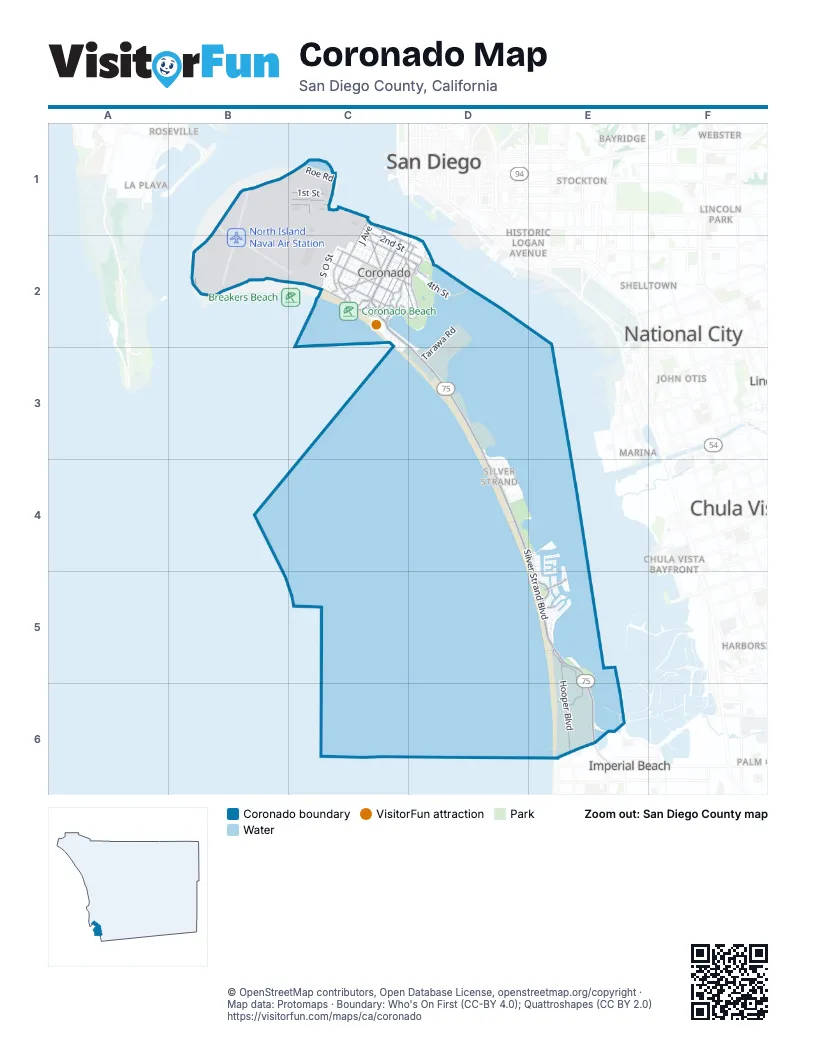
Street index of Coronado
Each street on the sheet and the grid squares it crosses.
- ChicaneB1, C1
- Coronado ChicaneB1
- Curtis StreetB1
- F RoadB1
- F Road WestB1
- Hanger RoadB1
- McCain West BoulevardB1
- Read RoadB1, C1
- Roe RoadB1, C1
- Runway RoadB1
- Saufley StreetB1, C1
- Vought StreetB1, C1
- 1st StreetC1, B2, D2
- 2nd StreetC1, B2, C2, D2
- 3rd StreetC1, B2, C2, D2
- 4th StreetC1, C2, D2
- A Road WestC1
- Alameda BoulevardC1, C2
- B Road EastC1, C2
- B Road WestC1
- Carson StreetC1
- Colorado StreetC1
- Corry StreetC1
- E AvenueC1, C2
- F AvenueC1, C2
- Flagpole CircleC1
- G AvenueC1, C2
- Gowan StreetC1
- H AvenueC1, C2
- I AvenueC1, C2
- J AvenueC1, C2
- Maxfield BoulevardC1
- McCain BoulevardC1, C2
- Murray StreetC1
- North 4th StreetC1
- Palm AvenueC1, C2
- Quay RoadC1
- Quentin Roosevelt BoulevardC1, B2, C2
- Rogers RoadC1, B2, C2
- South N AvenueC1, C2
- South R AvenueC1, C2
- Stockdale BoulevardC1
- Utgoff AvenueC1
- Wright AvenueC1
- Wright RoadC1, C2
- J Road EastB2, C2
- K RoadB2, C2
- Moffett RoadB2
- 10th StreetC2
- 5th StreetC2, D2
- 6th StreetC2, D2
- 7th StreetC2
- 8th StreetC2
- 9th StreetC2
- A AvenueC2, D2
- Acacia WayC2
- Adella AvenueC2
- Alder StreetC2
- Avenida de Las ArenasC2
- Avenida del MundoC2, C3
- Avenida del SolC2
- Avenida LunarC2, C3
- B AvenueC2, D2
- Balboa AvenueC2
- C AvenueC2
- Cabrillo AvenueC2
- Cajon PlaceC2, D2
- Carob WayC2
- Churchill PlaceC2
- Coronado AvenueC2
- Country Club LaneC2
- D AvenueC2
- Duffer LaneC2
- Encino LaneC2
- Encino RowC2
- F Road EastC2
- Flora AvenueC2
- G Road EastC2
- Glorietta BoulevardC2, D2
- Glorietta PlaceC2, D2
- Guadalupe AvenueC2, D2
- H Road EastC2
- I Road EastC2
- Isabella AvenueC2
- Jacinto PlaceC2
- Loma AvenueC2
- Loma LaneC2
- Margarita AvenueC2, D2
- Maria PlaceC2
- Marina AvenueC2
- Miguel AvenueC2, D2
- Monterey AvenueC2, D2
- Ocean BoulevardC2
- Ocean CourtC2
- Ocean DriveC2
- Olive AvenueC2
- Olive LaneC2
- Orange AvenueC2
- Park PlaceC2
- Park View PlaceC2
- Pine CourtC2
- Pine StreetC2
- Pomona AvenueC2, D2
- R.H. Dana PlaceC2
- San Luis Rey AvenueC2, D2
- Sherman RoadC2
- Silver Strand BoulevardC2, D2, D3, D4, E4, E5, E6
- South M AvenueC2
- South O StreetC2
- Star Park CircleC2
- Strand WayC2, D2, D3
- Tolita AvenueC2
- Ynez PlaceC2
- Attu RoadD2, D3
- Bay CircleD2
- Bougainville RoadD2, D3
- Eniwetok RoadD2
- Glorietta PlazaD2
- Glorietta RoadD2
- Guadalcanal RoadD2, D3
- Inchon RoadD2
- Kwajalein RoadD2
- Makin RoadD2, D3
- Marine WayD2
- Mullinex DriveD2
- Prospect PlaceD2
- Rio RoadD2, D3
- Soledad PlaceD2
- Tarawa RoadD2, D3
- Tulagi RoadD2, D3
- Visalia RowD2
- Vista PlaceD2
- South Seal WayC3, D3
- Admiralty RoadD3
- Desert StormD3
- Lae RoadD3
- Munda RoadD3
- Rendova CircleD3
- Rendova RoadD3
- Trident WayD3
- Vella Lavella RoadD3
- Attu AvenueD4
- Da Nang DriveD4
- Inchon CourtD4
- Leyte RoadD4
- Okinawa RoadD4
- Palau CircleD4
- Palau RoadD4
- Saipan RoadD4
- TunnelD4, E4
- Wake RoadD4
- Admiralty CrossE4, E5
- Coronado Bay RoadE4
- Coronado Cays BoulevardE4, E5
- Gingertree LaneE4
- Green Turtle RoadE4, E5
- Half Moon BendE4
- Jamaica Village RoadE4
- Montego CourtE4
- North Caribe Cay BoulevardE4, E5
- Sandpiper StrandE4
- Sixpence WayE4
- The PointE4
- Antigua CourtE5
- Aruba BendE5
- Bahama BendE5
- Blue Anchor Cay RoadE5
- Bridgetown BendE5
- Buccaneer WayE5
- Catspaw CapeE5
- Delaport CourtE5
- Delaport LaneE5
- Delaport PlaceE5
- Delaport WayE5
- Grand Caribe CausewayE5
- Halfpenny LaneE5
- Hooper BoulevardE5, E6
- Johnson StreetE5, E6
- Kingston Court EastE5
- Kingston Court SouthE5
- Kingston Court WestE5
- Kurtz CourtE5
- Mardi Gras CourtE5
- Mardi Gras RoadE5
- Port of Spain RoadE5
- Port Royale RoadE5
- Redman StreetE5
- Rowcliff BoulevardE5, E6
- Saint Christophers LaneE5
- Saint Kitts WayE5
- South Cays CourtE5
- Spinnaker WayE5
- Stone StreetE5, E6
- The InletE5
- Tobago WayE5
- Trinidad BendE5
- Tunapuna LaneE5
- Carnation AvenueE6
- Seacoast DriveE6
- Silver StrandE6
Things to do on the Coronado map
Places on the map
- 1906 Lodge
- Administration Building
- Bachelor's Officer's Quarters
- Bank of America
- Best Western Plus Suites Hotel Coronado Island
- Camp Surf
- Centennial Park
- Chase
- Coronado Beach
- Coronado Cays Park
- Coronado Ferry Landing
- Coronado Golf Course
- Coronado High School
- Coronado Post Office
- Coronado Tidelands Park
- Fiddlers Cove RV Park
- Hotel Del Coronado
- Naval Air Station North Island
- Naval Amphibious Base Coronado
- North Island Naval Air Station
- Pond 10
- Pond 11
- Sea 'N Air Golf Club
- Sharp Coronado Hospital
- Silver Strand Natural Preserve
- Silver Strand State Beach
- Silver Strand Training Complex (North)
- Silver Strand Training Complex (South)
- South Bay County Biological Study Area
- The UPS Store
- The Victorian
Next to Coronado
- Bayridge
- Chula Vista map
- Chula Vista Bayfront
- Cortez Hill
- Egger Highlands
- Gaslamp Quarter
- Grant Hill
- Harbor District
- Harborside
- Historic Logan Avenue
- Imperial Beach map
- John Otis
- La Playa
- Lincoln Park
- Lower Sweetwater
- Marina
- National City map
- Olivewood
- Palm City
- Rancho de la Nación
- Roseville map
- San Diego map
- Shelltown
- Stockton
- Third Avenue Village
- Valencia Park
- Webster
© OpenStreetMap contributors, Open Database License, openstreetmap.org/copyright · Map data: Protomaps · Boundary: Who's On First (CC-BY 4.0); Quattroshapes (CC BY 2.0)















