

California map
San Diego map
About 1,404,452 people live here (Census Bureau, 2024 estimate). The sheet's index lists 33 streets; Escondido Freeway, Jacob Dekema Freeway and San Diego Freeway cross the most grid squares. Things to do inside the boundary: Balboa Park, Bazaar Del Mundo and Belmont Park.
Open the map (PDF, US Letter)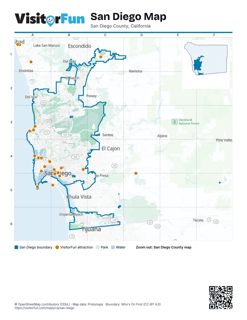
Street index of San Diego
Each street on the sheet and the grid squares it crosses.
- Escondido FreewayB1, B2, B3, B4, B5
- Carmel Valley RoadA2
- San Diego FreewayA2, A3, A4, B4
- Ted Williams FreewayA2, B2, A3
- Tony Gwynn Memorial FreewayB2, B3
- Jacob Dekema FreewayA3, B3, B4, B5, C6
- La Jolla ParkwayA3
- Soledad FreewayA3, B3
- Cabrillo FreewayB3, B4
- Hillery DriveB3
- San Clemente Canyon FreewayB3, C3
- Semper Fi HighwayB3
- Mission Valley FreewayA4, B4, C4
- Ocean Beach FreewayA4
- Cabrillo ParkwayB4
- John J. Montgomery FreewayB4, B5, B6, C6
- Martin Luther King Junior FreewayB4, B5
- Route 75B5
- South Bay FreewayB5, C5
- Avenida InternacionalB6, C6
- Otay Mesa FreewayB6, C6
- All Travelers LaneC6
- Boulevard Garita de OtayC6
- Carretera TranspeninsularC6
- Carril ListoC6
- Carril SENTRI de entrada globalC6
- Global Entry SENTRI LaneC6
- Linea Global Entry SENTRIC6
- Linea NormalC6
- Ready LaneC6
- Ready Lane (Línea)C6
- Route 11C6
- South Bay ExpresswayC6
Things to do on the San Diego map
- Balboa Park
- Bazaar Del Mundo
- Belmont Park
- Big Blue Photo Boat
- Birch Aquarium at Scripps
- Cabrillo National Monument
- Ciné Café
- Cruise San Diego
- Fiesta de Reyes
- Gaslamp BBQ
- Liberty Public Market
- Maritime Museum of San Diego
- Navy SEAL Museum San Diego
- Old Town San Diego
- Old Town San Diego State Historic Park
- Old Town Trolley Tours of San Diego
- Old Town Trolley Tours San Diego
- Petco Park Tour
- Ringer's Roller Rink
- San Diego Model Railroad Museum
- San Diego Natural History Museum
- San Diego Watercolor Society Gallery
- San Diego Whale Watch
- San Diego Zoo
- San Diego Zoo Safari Park
- SeaWorld San Diego
- Spanish Village Art Center
- Surf Diva
- The Old Globe Theatre
- USS Midway Museum
- Weekend Outside
- Whaley House Museum
- Wild Pacific Whale Watch
Places on the map
- 34th Street Canyon Open Space
- Aero Court Naval Housing
- Alexandria Campus Point
- Alvarado Estates
- Arero Ridge
- Balboa Park
- Black Mountain Open Space Park
- Black Mountain Ranch
- Border Field State Park
- Cabrillo National Monument
- Carlton Oaks Golf
- Carmel Mountain Preserve
- Carmel Valley
- Carroll Canyon Quarry
- Championship Course
- Chollas Operations Yard
- Chollas Park
- Chollas Parkway Open Space
- Chollas Radio System
- Core–Columbia
- Cortez Hill
- Crest Canyon Open Space Park
- Del Mar Heights
- Del Mar Mesa
- Downtown San Diego
- East Village
- Egger Highlands
- Elliott Chaparral Reserve
- Fairbanks Ranch Country Club
- Fiesta Island Dog Park
- Flinkote Torrey Pines Trail
- General Dynamics
- Gonzales Canyon Open Space
- Jamacha
- Junipers
- Kensington
- La Jolla
- La Jolla Shores Beach
- Lake Hodges
- Lake Miramar
Next to San Diego
- 4S Ranch
- Alpine
- Bonita
- Chula Vista map
- Coronado
- Del Dios
- Del Mar
- El Cajon
- Encinitas
- Escondido
- Imperial Beach
- Julian
- La Mesa
- La Presa
- Lake San Marcos
- National City
- Pine Valley
- Poway
- Ramona
- Rancho Santa Fe
- San Diego Country Estates
- San Marcos
- Santee
- Spring Valley
- Tecate
- Tijuana
© OpenStreetMap contributors (ODbL) · Map data: Protomaps · Boundary: Who's On First (CC-BY 4.0)