

Colorado map
Westminster map
About 115,302 people live here (Census Bureau, 2024 estimate). The sheet's index lists 300 streets; Denver–Boulder Turnpike, West 112th Avenue and West 108th Avenue cross the most grid squares. Also on it: Big Dry Creek Open Space, Hyland Ponds Open Space and Ketner Open Space.
Open the map (PDF, US Letter)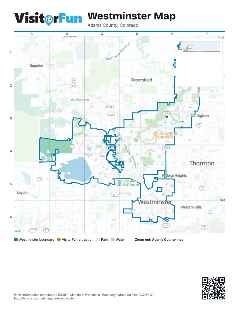
Street index of Westminster
Each street on the sheet and the grid squares it crosses.
- Denver–Boulder TurnpikeC3, C4, D4, D5, E5, E6
- Dwight D. Eisenhower HighwayF1, F2, F3
- North Federal BoulevardE3, E4, E5, E6
- North Sheridan BoulevardD3, D4, D5, D6
- West 104th AvenueB4, C4, D4, E4
- West 120th AvenueD3, E3, F3
- West 92nd AvenueC5, D5, E5
- North Wadsworth ParkwayC3, C4, C5
- West 88th AvenueB5, C5, D5, E5
- West 72nd AvenueD6, E6
- Church Ranch BoulevardC4, D4
- West 136th AvenueE2, F2
- West 144th AvenueE1, F1
- North Wadsworth BoulevardC3, C4, C5
- Sheridan BoulevardD3, D6
- West 86th ParkwayC5
- Jason DriveE1
- East 144th AvenueF1
- Federal BoulevardE5, E6
- North Huron StreetF1, F2, F3
- North Westminster BoulevardD3, D4, D5
- North Lowell BoulevardE3, E4, E5, E6
- West 112th AvenueB3, C3, D3, E3, F3
- West 100th AvenueB4, C4, D4, E4
- North Simms StreetB3, B4
- North Zuni StreetE2, E3, E5
- West 128th AvenueE2, F2
- West 84th AvenueD5, E5
- West 80th AvenueD5, E5
- Lowell BoulevardE3, E6
- North Indiana StreetA4
- North Federal ParkwayE2, E3
- Zuni StreetE2, E5, E6
- Huron StreetF3
- East 128th AvenueF2
- East Midway BoulevardE2
- Community Center DriveF3
- West 108th AvenueE3, B4, C4, D4, E4
- North Orchard ParkwayF1, F2
- West 94th AvenueC4, D4, E4, C5, D5
- West 96th AvenueA4, B4, C4, D4, E4
- North Pecos StreetE1, E2, E3
- West 99th AvenueC4, D4, E4
- West 73rd AvenueD6, E6
- West 74th AvenueD6, E6
- West 98th AvenueC4, D4, E4
- North Irving StreetE4, E5, E6
- West 76th AvenueD6, E6
- West 90th AvenueC5, D5, E5
- North Pierce StreetD4, D5
- West 103rd AvenueB4, C4, D4, E4
- West 101st AvenueB4, C4, D4, E4
- North Yates StreetD5, D6
- Legacy Ridge ParkwayE3, D4, E4
- Wolff StreetD3, D4, D5
- West 116th AvenueD3, E3
- West 122nd AvenueE3, F3
- West 118th PlaceD3, E3
- West 132nd AvenueE2, F2
- West 115th AvenueD3, E3, F3
- West 106th AvenueB4, C4
- Eaton StreetD3, D4
- North Delaware StreetF1, F2, F3
- West Westmoor DriveB3, C3, C4
- North Eaton StreetD5, D6
- Oak StreetB4
- Countryside DriveB4, C4
- West Turnpike DriveD5, E5, E6
- North Utica StreetD3, D4, D5, D6
- West 91st AvenueC5, D5, E5
- Independence StreetC4, C5
- West Westcliff ParkwayC4, D4
- Independence DriveC4, C5
- Garrison StreetC4, C5
- North City Center DriveD4, D5
- North Harmony ParkwayE2
- Hooker StreetE4, E5
- West 104th DriveB4, C4, D4, E4
- Lamar StreetD3, D4, D5, D6
- Huntington Trails ParkwayE1, F1
- North Bradburn BoulevardD5, D6
- West Promenade Drive NorthC4, D4
- West Promenade Drive SouthD4
- West 70th AvenueD6, E6
- Moore StreetB4, C4
- North Park Centre DriveE3
- Kendall StreetD3, D4, D5
- North Harlan StreetD5, D6
- Stratford Lakes DriveE3
- North Alkire StreetB4, B5
- West 134th AvenueE2, F2
- Northpark AvenueE4
- Bruchez ParkwayE4
- West 124th AvenueE2, F2, E3, F3
- North Vance StreetC5
- West 88th PlaceC5, D5
- Garland StreetC4, C5
- Stuart StreetD3, D4
- Vrain StreetD3, D4, D5
- Yarrow StreetC3, C4, C5
- West Westmoor CircleB3
- North Reed StreetC4, D4
- Alcott StreetE3, E4
- West 68th AvenueD6, E6
- West 130th DriveE2
- Teller StreetC4, C5, D5
- West Oakwood DriveD5
- North Quivas StreetE2
- Field StreetC5
- North Bradburn DriveD5, E5
- Johnson StreetC4
- West 146th AvenueF1
- Grove LoopE4
- North Kalamath StreetE2
- 8600 WestC4
- West 125th AvenueF2
- West 142nd AvenueF1
- Cody StreetC5
- Independence WayC4, C5
- Skyestone ParkwayB4
- West 138th AvenueF2
- Lamar DriveD5
- Kalamath StreetE2
- West 110th AvenueC3, D3, E3
- West 95th AvenueC4, D4, E4
- West 105th AvenueB4, C4, D4, E4
- West 113th AvenueD3, E3
- North Raleigh StreetD4, D5, D6
- North Newton StreetE4, E5, D6, E6
- West 93rd AvenueD4, E4, C5, D5, E5
- West 111th AvenueC3, D3, E3
- West 107th PlaceB4, C4, D4, E4
- North Osceola StreetD4, E4, D5, E5, D6
- West 102nd AvenueB4, C4, D4, E4
- West 108th CircleC3, C4, D4
- Grove StreetE3, E4, E5
- Dover StreetC3, C4, C5
- North Meade StreetE4, E5, E6
- North Stuart StreetD5, D6
- North Clay StreetE3, E4, E5, E6
- West 92nd PlaceE4, C5, D5, E5
- West 97th AvenueC4, D4, E4
- West 107th DriveC4, D4, E4
- West 109th CircleD3, E3, D4, E4
- West 75th AvenueD6, E6
- West 86th AvenueC5, E5
- King StreetE3, E4
- North Bryant StreetE3, E5, E6
- North Julian StreetE5, E6
- Ingalls StreetD3, D4, D5
- North Decatur StreetE3, E4, E5, E6
- West 109th AvenueC3, D3, E3, D4
- West 94th PlaceC4, D4
- West 107th AvenueB4, C4, E4
- West 117th AvenueD3
- West 110th PlaceC3, D3, E3
- West 105th DriveB4, D4, E4
- West 91st PlaceC5, D5, E5
- North Tejon StreetE2, E3
- North Tennyson StreetD5, D6
- West 102nd PlaceB4, C4, D4, E4
- West 121st AvenueE3, F3
- West 114th CircleE3
- Owens StreetB4
- North Alcott StreetE3, E5, E6
- West 148th AvenueE1, F1
- North Quivas WayE3
- North Knox CourtE5, E6
- North Winona CourtD5, D6
- North Yates DriveD3, D4, D5
- West 111th DriveE3
- West 109th PlaceC3, D3, D4, E4
- West 78th AvenueD5, E5, D6
- West 87th PlaceC5, E5
- West 97th PlaceC4, D4
- North Grove StreetE5, E6
- Decatur StreetE3, E4, E5
- Ames StreetD4
- North Depew StreetD6
- Otis StreetD3, D4, D6
- Yukon StreetC3, C4, C5
- West 81st AvenueD5, E5
- Gray StreetD3, D4
- Benton StreetD3, D4, D6
- West 104th PlaceB4, C4, D4, E4
- Jay StreetD3, D4, D6
- North Perry StreetD4, D5
- West 108th PlaceC3, D3, E3, C4, D4
- West 106th PlaceB4, C4, E4
- Perry StreetD3, D4
- Cotton Creek DriveD3, D4
- Harlan StreetD3, D4, D5
- West 99th PlaceC4, D4, E4
- West 105th WayB4, C4, D4
- Lexington AvenueE1, E2, F2
- North Canosa CourtE6
- North Hooker StreetE5, E6
- Quitman StreetD3, D4, D5
- North Wolff StreetD6
- West 100th CircleC4
- West 73rd PlaceD6, E6
- West 90th PlaceC5, E5
- Decatur DriveE3
- Newland StreetD3, D4
- West 82nd AvenueD5, E5
- Irving StreetE3, E4, E5, E6
- West 112th PlaceD3, E3
- West Country Club LoopE3
- North Xavier StreetD5, D6
- West 96th DriveC4, D4
- West 89th AvenueC5, D5
- West 119th AvenueE3, F3
- Pecos StreetE1
- West 111th LoopE3
- West 90th DriveC5, D5
- North Vrain StreetD5, D6
- Ranch Reserve ParkwayE3
- West 95th DriveC4
- Chase StreetD3, D4, D6
- North Raritan StreetE2, E3
- Hoyt StreetC4, C5
- West 115th PlaceD3, E3
- West 118th AvenueD3, E3, F3
- Carr StreetC4, C5
- West 111th PlaceD3, E3
- North Quitman StreetD5, D6
- West 71st AvenueD6, E6
- Owens CircleB4
- West 105th PlaceB4, C4, D4, E4
- West 98th PlaceC4, D4, E4
- West 100th PlaceB4, C4, D4, E4
- West 72nd DriveD6
- North Circle DriveD5
- West 103rd DriveB4, D4, E4
- King CourtE3, E4
- West 103rd PlaceB4, D4, E4
- Brentwood WayC4, C5
- West 107th CircleB4, C4, D4
- Julian StreetE3, E4
- North Raleigh PlaceD5
- North King StreetE5, E6
- Marshall StreetD3, D6
- Routt StreetB4
- North Green CourtE5
- Lexington PlaceE1, E2
- West 101st PlaceB4, C4, E4
- North Osage StreetE1, E2, E3
- Wolff CourtD3, D4, D5
- West 95th PlaceD4, E4
- North Home Farm DriveE2, F2
- West 116th WayD3, E3
- North Vallejo CircleE2
- Winona CourtD3, D4
- West 71st PlaceD6, E6
- Bradburn BoulevardD3, E3
- North Mariposa StreetE1, E2, E3
- West Harmony Park DriveE2
- Osceola StreetD3, D6
- West 69th AvenueD6, E6
- North Zenobia StreetD5, D6
- West 79th AvenueD5, E5
- Chase WayD3
- West 100th DriveB4, E4
- West 133rd CircleE2, F2
- West Skyline DriveE6
- Lexington CircleE1
- Garrison DriveC4, C5
- Xavier DriveD3
- North Navajo StreetE1, E2, E3
- West 86th DriveC5, E5
- Main StreetD3, E3
- Hobbit LaneE4
- Balsam StreetC3, C4, C5
- West 141st CircleE1
- West 133rd WayE2
- West 87th AvenueE5
- North Benton StreetD5, D6
- Holland StreetC4, C5
- West 77th AvenueD6, E6
- Newton StreetD3, E3
- Jellison WayC4
- Flower StreetC4, C5
- West 116th PlaceD3, E3, F3
- North Beach StreetE3, E6
- West 75th PlaceD6, E6
- Zephyr StreetC3, C4
- Marshall CourtD3, D5
- Bryant StreetE3, E4
- Nelson StreetB4, C4
- North Umatilla CourtE2
- Turnpike DriveD5
- West 135th PlaceE2
- Meade CourtE3, E4
- West 107th CourtC4, D4, E4
- Carr CircleC4, C5
- West 87th DriveC5
- North Turnpike DriveD5
- West 104th CircleB4, C4, E4
- Eliot CircleE4, E6
- West 135th AvenueE2
Places on the map
- Big Dry Creek Open Space
- Bradburn
- Caroll Butts Park
- Church Ranch Office Park
- Country Club Village
- Coyote Gulch Campground
- Devereux Cleo Wallace
- Hyland Ponds Open Space
- Jackson Lake
- Ketner Open Space
- Ketner Reservoir
- Legacy Ridge
- Legacy Ridge Clubhouse
- Lower Church Lake Open Space
- McKay Lake
- McKay Lake Open Space
- Metzger Farm Open Space
- Middle Hylands Creek Open Space
- Mountain Range High School
- Oakhurst Park
- Overland Trail Open Space
- PAM Health Rehabilitation Hospital of Westminster
- Quail Creek Open Space
- Ranch Creek Open Space
- Ranch Open Space
- Rocky Mountain Shopping Center
- Standley Lake
- Standley Lake Regional Park
- Tanglewood Creek Open Space
- The Orchard Town Center
- The Ranch Country Club
- Walmart Retail Center
- Walnut Creek
- Walnut Creek Golf Preserve
- Walnut Creek Open Space
- Westminster Crossing
- Westminster Hills Open Space
- Westminster Hills Trail
- Westminster Open Space
- Westminster Promenade
Next to Westminster
- Broomfield map
- Federal Heights map
- Flatiron Crossing
- Interlocken
- Leyden
- Northglenn map
- Sherrelwood
- Superior map
- Thornton map
- Twin Lakes
- Western Hills
© OpenStreetMap contributors, Open Database License, openstreetmap.org/copyright · Map data: Protomaps · Boundary: Who's On First (CC-BY 4.0); Quattroshapes (CC BY 2.0)















