

Colorado map
Broomfield map
About 78,323 people live here (Census Bureau, 2024 estimate). The sheet's index lists 300 streets; Northwest Parkway, Denver–Boulder Turnpike and Dwight D. Eisenhower Highway cross the most grid squares. Things to do inside the boundary: FlatIron Crossing.
Open the map (PDF, US Letter)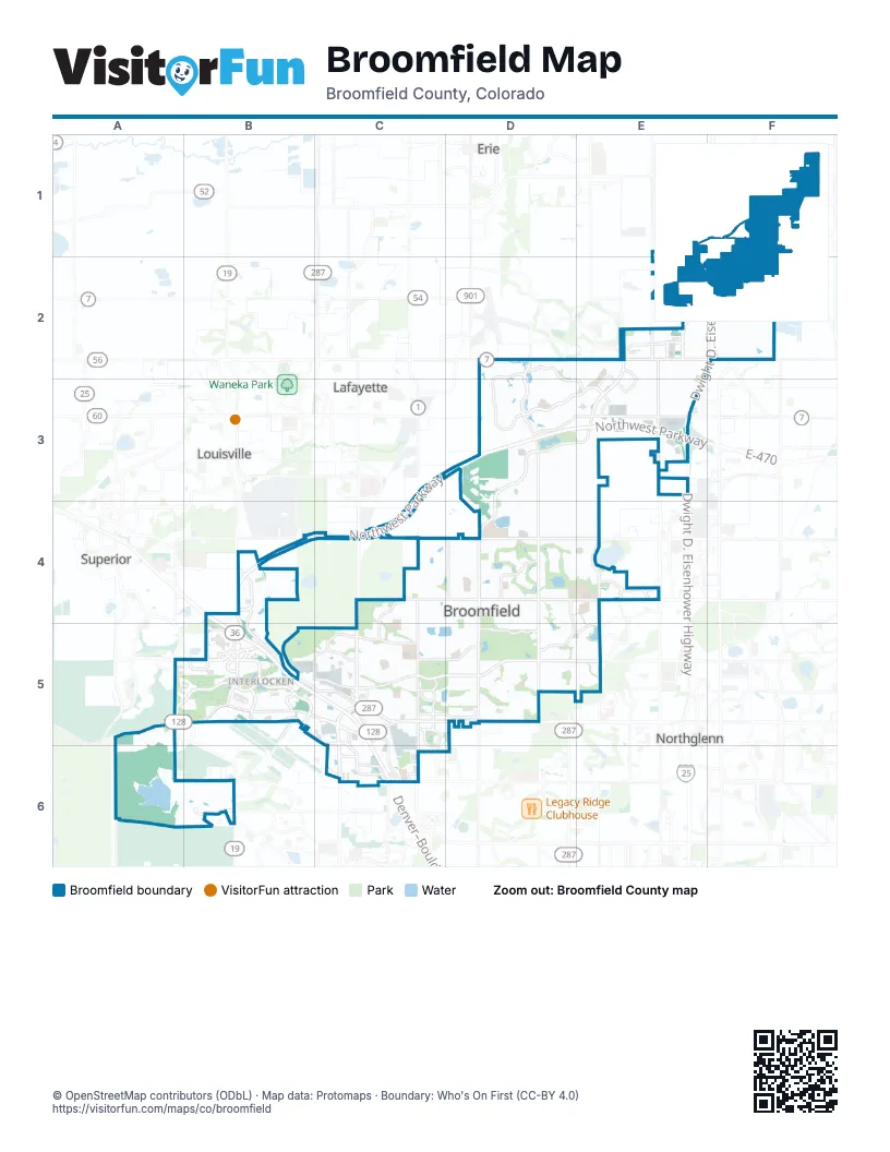
Street index of Broomfield
Each street on the sheet and the grid squares it crosses.
- Northwest ParkwayC3, D3, E3, B4, C4, B5
- Denver–Boulder TurnpikeB4, B5, C5, C6
- Dwight D. Eisenhower HighwayF1, E2, F2, E3
- E-470E3
- Sheridan ParkwayE2, D3, E3, D4
- Interlocken LoopB5, C5
- West 120th AvenueB5, C5, D5
- Sheridan BoulevardD4, D5
- West 144th AvenueD4, E4
- State Highway 7D2, E2, F2
- West Dillon RoadB4, C4, D4
- Wadsworth ParkwayC5, C6
- Via VarraB4
- 96th StreetB4
- South 112th StreetC4
- North Sheridan BoulevardD5
- Tennyson WayD5
- Lowell BoulevardD2, D3, D4, D5
- East Midway BoulevardC5, D5, E5
- West 136th AvenueC4, D4, E4
- Huron StreetE2, E3
- Zuni StreetE3, E4, E5
- West Midway BoulevardB4, B5, C5
- Interlocken BoulevardB5
- Eldorado BoulevardA5, B5
- Main StreetC4, C5, C6
- West Flatiron Crossing DriveB5
- Uptown AvenueC5, C6
- Summit BoulevardF1, A5, B5
- West 112th AvenueA6, B6, C6
- Promenade StreetE2, E3
- Coalton RoadA5, B5
- North Indiana StreetA6
- North Zuni StreetE4, E5
- East 168th Avenue / County Road 2F2
- East Flatiron Crossing DriveB5
- South 120th StreetC3, C4
- North Huron StreetE3
- North Simms StreetA5
- West 128th AvenueE5
- County Road 7E2
- North Federal ParkwayE5
- North Westminster BoulevardC6
- Preble Creek ParkwayD3, E3
- East I-25 Frontage RoadF1, F2
- West 160th AvenueD3, E3
- Indian Peaks ParkwayD2, D3, E3
- Anthem Ranch RoadD2, D3
- Aspen StreetD4, D5
- Kohl StreetC4, C5
- East 1st AvenueC5, D5
- Miramonte BoulevardC5
- Broadlands DriveD4
- Skyestone ParkwayB6
- Industrial LaneB5, C5
- West Flatiron CircleB5
- West 169th AvenueE2
- Wadsworth BoulevardC5, C6
- Westlake DriveD4, D5
- West 10th AvenueC5
- Greenway DriveC5, C6
- Alcott WayE2, E3, E4, E5
- County Road 6F1
- East 10th AvenueC5, D5
- West 138th AvenueE4
- Broomfield County Commons DriveD5
- Network ParkwayB5
- Spader WayC5
- Commerce StreetC5, C6
- Interlocken ParkwayB5
- West 116th AvenueC6
- Arista PlaceC6
- Flatiron BoulevardB5
- Destination DriveC5, C6
- Parkland StreetC6
- East 3rd AvenueC5, D5
- Nickel StreetC5
- Airport WayB5
- Palisade ParkwayE2
- Metro Airport AvenueB5, C5
- West 132nd AvenueD5, E5
- West 167th AvenueE2, E3
- Oak Circle SouthB5, C5
- Reed WayC6
- East 13th AvenueD5
- Zang StreetB5
- Vrain StreetD5
- Hoyt StreetB5, C5
- Flatiron Marketplace DriveB5
- North Greenway DriveC5
- West 119th AvenueC5
- Quivas StreetE4
- Descombes DriveC5
- Misty StreetD4, D5
- West 118th AvenueC5, D5
- Kalamath StreetE4
- Ridge View DriveE2
- Lamar StreetC5
- West 113th PlaceC6
- Greenway Drive WestC5
- Bonanza DriveD2
- Chase StreetD5
- Paul Derda Rec Ctr DriveD5
- Paul Derda Rec. Center DriveD5
- North Harmony ParkwayE5
- West 120th WayB5
- Greenway Drive NorthC5
- Jeffco Airport AvenueB5
- South Tyler DriveB5
- Kendall StreetC6
- York StreetF1
- North Quivas StreetE4
- County Road 11F1, F2
- Ridge ParkwayA5
- Raven RunD3
- West 152nd AvenueD3, E3
- West 6th AvenueC5
- Opal StreetC5
- Irving StreetD3, D4, D5
- Daphne StreetC4, C5
- Red Deer TrailD4, D5
- Emerald StreetC4, C5
- Birch StreetD4, D5
- Silver Feather CircleD3
- Rabbit Mountain RoadD4, D5
- East 14th AvenueC4, D4, C5
- West I-25 Frontage RoadF1, F2
- Netta DriveE2, F2
- Aspen Creek DriveD4
- West 1st AvenueC5
- Alter StreetC5
- Ridge DriveC5
- West 124th AvenueD5
- Waterside LaneE4
- Perry StreetD5
- West 149th AvenueD3, E3
- Windom LoopD2, E2, D3, E3
- Front Range CircleE5
- Olive StreetE2
- Federal BoulevardD3, D4
- Boulder CircleD4
- Ash StreetD5
- Hemlock WayC4, C5
- Lilac StreetC5
- McKay Park CircleE4
- Iris StreetC4, C5
- Dexter StreetD4, D5
- Grove WayD4, D5, E5
- Alcott StreetE4, E5
- Laurel StreetC5
- Lake Song LaneE4
- West 134th PlaceD4, E4, D5, E5
- Shannon DriveD4
- Prospect LaneE2, E3
- Pikes Peak DriveD3
- Cedar StreetD4, D5
- West 126th AvenueD5, E5
- Garnet StreetC4, C5
- West 123rd PlaceD5
- East 12th AvenueC5, D5
- Spinnaker WayE2
- Spruce Meadows DriveE3
- Whistlepig LaneC4, D4
- Plaster CircleD4
- Yale DriveD3
- Cottonwood StreetD4, D5
- Aspen Lodge WayD3
- West 127th AvenueD5
- West 135th AvenueD4, E4
- Augusta DriveD4
- Clay StreetE3, E4
- Park Cove DriveD4, E4
- West 128th PlaceD5, E5
- Belford CircleD3
- Garden CenterC5
- Dover StreetD4, D5
- Outlook TrailC4
- South Princess CircleD5
- High Prairie WayD3, E3
- Broadlands LaneD4
- Wild Horse DriveD3
- Highland Park DriveD5
- Burbank StreetC5
- Antero CircleD2, D3
- Teller StreetC5, C6
- Bryant CircleE5
- King CircleD5
- Mariposa StreetE2, E4
- Trinity LoopD2, E2
- Lowell LaneE2
- West 125th AvenueD5, E5
- Willow Run ParkwayE5
- Spruce StreetD3, E3
- Mountain View CircleD3, E3
- West 133rd AvenueD5, E5
- West 134th CircleD4, E4
- Flint WayC5
- West 119th PlaceC5
- West 116th CircleC6
- Deer Mountain CircleD3
- Wolff StreetD5
- Drake StreetE2
- Longs Peak DriveC5
- Wild Basin WayD4, D5
- Marble StreetC5
- Legend WayD4
- Quantum ParkwayB6
- Crestone CircleD4
- Maria CircleD5
- Ute Peak WayE2, D3, E3
- Clubhouse DriveC5
- Patty Gabriel WayD4
- Agate WayC5
- 176th AvenueE2
- County Road 4E2
- Whitney CircleD4
- West Montane DriveA6, B6
- Legend TrailD4
- Interlocken CrescentB5
- Elmwood StreetD4, D5
- 10th AvenueC5
- Quail Creek DriveD4, E4
- Jade StreetC5
- Promontory LoopD3, E3
- Quandary LoopD3
- Grizzly Peak DriveD3
- West 166th AvenueE2, E3
- Tiverton AvenueE4
- Pinehurst CircleD4
- Meadowlark LaneB6
- Bellaire StreetD4, D5
- Himalaya AvenueC4
- Parkside Center DriveD2, D3
- Clay CircleE5
- Hemlock StreetC5
- McIntosh AvenueD5
- West 3rd AvenueC5
- Columbine AvenueC4
- Environmental WayB5
- White Rock DriveD3
- Utica StreetD5
- Irving CourtD3, D4, D5
- Stonehaven AvenueD5
- Bear Cub DriveA6
- Piney River RoadD4
- Briarwood DriveD4, D5
- Nelson DriveD4
- West 133rd CircleE4, D5, E5
- Transit WayC6
- West 2nd AvenueC5
- East 9th AvenueD5
- Sandstone DriveA6, B6
- Silver Mountain LoopD3
- Beryl WayC5
- Service access roadE3
- South 104th StreetB4
- Dogleg LaneD4
- West 7th Avenue DriveC5
- Berthoud TrailC4
- Alexander WayD2, D3
- Durango AvenueC4, D4
- Mulberry CircleC5, C6
- Avalanche RunD3, E3
- Longs CourtD4
- Hope CircleD3
- East 11th AvenueC5, D5
- Broadmoor LoopD4
- Williams PlaceD3
- Inverness StreetD5
- Fairway LaneD4
- Delaware StreetE2, E3
- Bierstadt LoopD2
- San Luis WayD3
- Alcott CircleE4, E5
- Alley AE4
- McKay Landing ParkwayE4
- West 3rd Avenue DriveC5
- Snowy Owl DriveC4, D4
- Vestal LoopD2
- West 10th Avenue PlaceB5, C5
- Brainard DriveB4, B5
- Stuart CourtD4, D5
- Traver DriveD2
- Gunnison WayC4
- Aberdeen DriveD5
- Eagle River LoopD3, D4
- Kestrel DriveD3
- South Brainard DriveB4, B5
- Buffalo Grass LoopD3
- Oak Circle NorthB5, C5
- Telluride DriveC4
- King Lake TrailD4, D5
- Sun Blaze LoopD4
- Community Park RoadC5
- Abilene DriveC5
- West 126th DriveD5
- Colony CircleC6
- King CourtD3
- Castle CircleD4
- Star Creek DriveD4, E4
Things to do on the Broomfield map
Places on the map
- Alex & Michaels Park
- Anthem Community Park
- Arista 36
- Aspen Creek PK-8 School
- Atria
- Brandywine North Park
- Brandywine South Park
- Broadlands Golf Course
- Broadlands Shopping Center
- Broadlands West Park
- Bronco Park
- Broomfield Community Park
- Broomfield Corners
- Broomfield Corners Subsidiary
- Broomfield County Commons Open Space
- Broomfield County Commons Park
- Broomfield Industrial Park
- Broomfield Marketplace
- Broomfield Town Centre
- Cobblestone Crossing
- Country Vista Park
- Flatiron Crossing
- Flatiron Marketplace
- Frank Varra Park
- Garden Center
- Great Western Reservoir
- Holy Family High School
- Interlocken
- Interlocken Golf Course
- Lac Amora Open Space
- Legacy High School
- Mathew Glasser Reservoir
- North Midway Park
- Plaster Open Space
- Prospect Ridge Academy
- Rocky Mountain Metropolitan Airport
- Shops at Quail Creek
- Siena Reservoir
- The Field Open Space
- Willow Run Open Space
Next to Broomfield
© OpenStreetMap contributors, Open Database License, openstreetmap.org/copyright · Map data: Protomaps · Boundary: Who's On First (CC-BY 4.0); Quattroshapes (CC BY 2.0)















