

Florida map
Jacksonville Metro Area map
The sheet's index lists 23 highways; I-95, US 1 and I-295 cross the most grid squares. Things to do inside the boundary: Amelia Island Museum of History, Amelia Island State Park and Anastasia State Park. Also on it: Callahan, Durbin and Fernandina Beach.
Open the map (PDF, US Letter)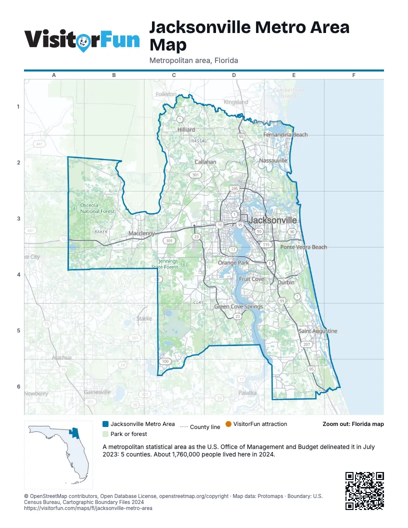
Highway index of Jacksonville Metro Area
Each highway on the sheet and the grid squares it crosses.
- I-10A3, B3, C3, D3
- I-95D1, D2, D3, D4, E4, E5, E6, F6
- I-295D2, D3, D4, E3, E4
- US 1C1, C2, D2, D3, E4, E5
- US 17D3, D4, D5
- US 23C1, C2, D2, D3
- US 90D3, E3
- US 301C1, C2, C3, C4, D2
- GA 4C1
- SR 9BE4
- SR 10D3, E3
- SR 13D3, D5, E5
- GA 15C1
- SR 16D5, E5
- SR 23C3, C4, D4, D5
- SR 100C6
- SR 113E3
- SR 115D3, E3, E4
- SR 126D3
- SR 200D2, E2
- SR 202D3, E3
- SR 207E5, E6
- SR 228C4, D3
Things to do on the Jacksonville Metro Area map
- Amelia Island Museum of History
- Amelia Island State Park
- Anastasia State Park
- Castillo de San Marcos National Monument
- Fort Caroline National Memorial
- Fort Mose Historic State Park
- James Weldon Johnson Park
- Lightner Museum
- Lincolnville Museum and Cultural Center
- Military Museum of North Florida
- Museum of Contemporary Art Jacksonville
- Spanish Military Hospital Museum
- St. Augustine Alligator Farm Zoological Park
- St. Augustine National Cemetery
- St. Augustine Visitor Information Center
- St. George Street
- Timucuan Ecological and Historic Preserve
Places on the map
- Callahan
- Durbin
- Fernandina Beach
- Fruit Cove
- Green Cove Springs
- Hilliard
- Jacksonville
- Macclenny
- Nassauville
- Orange Park
- Ponte Vedra Beach
- Saint Augustine
© OpenStreetMap contributors, Open Database License, openstreetmap.org/copyright · Map data: Protomaps · Boundary: U.S. Census Bureau, Cartographic Boundary Files 2024