

Florida map
Miami Beach map
About 83,251 people live here (Census Bureau, 2024 estimate). The sheet's index lists 300 streets; Collins Avenue, Alton Road and Meridian Avenue cross the most grid squares. Things to do inside the boundary: Art Deco Historic District & Ocean Drive, Collins Park and Fontainebleau Miami Beach.
Open the map (PDF, US Letter)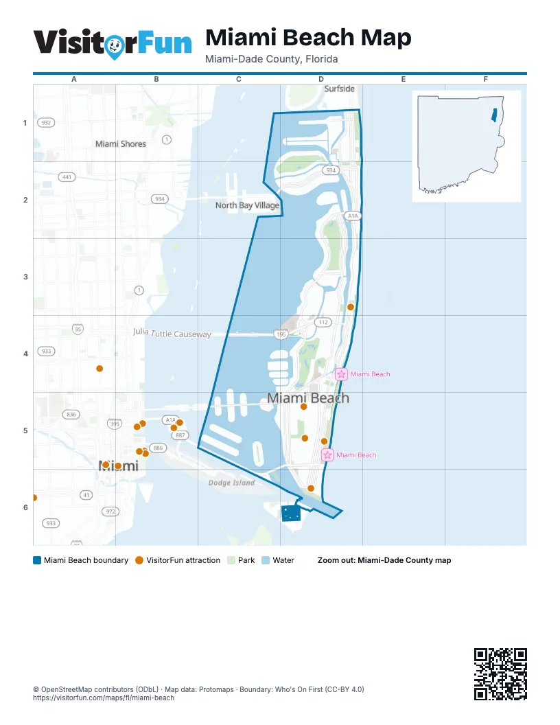
Street index of Miami Beach
Each street on the sheet and the grid squares it crosses.
- Julia Tuttle CausewayC4, D4
- Alton RoadD2, D3, D4, D5, D6
- Collins AvenueD1, D2, D3, D4, D5, D6
- MacArthur CausewayC5, D5, C6
- Indian Creek DriveD2, D3, D4
- Harding AvenueD1, D2
- 71st StreetD2
- 5th StreetD5
- Normandy DriveD2
- Abbott AvenueD1, D2
- 41st StreetD4
- West 63rd StreetD2
- West 44th StreetD3, D4
- John F. Kennedy CausewayC2, D2
- 63rd StreetD2
- 43rd StreetD4
- 26th StreetD4
- 5500 BlockD3
- 5455 ExitD3
- 5875 BlockD2
- 5300 BlockD3
- 4700 BlockD3
- 5455 EntranceD3
- 5330 BlockD3
- 5000 BlockD3
- 5200 BlockD3
- 5700 BlockD2
- 4900 BlockD3
- 4600 BlockD3
- 4500 BlockD3
- Pine Tree DriveD2, D3, D4
- Washington AvenueD4, D5, D6
- La Gorce DriveD2, D3
- Venetian WayC5
- Dade BoulevardD4, C5, D5
- 23rd StreetD4
- Fisher Island DriveD6
- Ocean DriveD5, D6
- West AvenueD4, D5
- Collins Avenue Service RoadD2, D3
- Byron AvenueD1, D2
- Jefferson AvenueD4, D5, D6
- 17th StreetD5
- 11th StreetD5
- 73rd StreetD1, D2
- South Pointe DriveD6
- Dickens AvenueD1, D2
- West 51st StreetD3
- 85th StreetD1
- Tatum Waterway DriveD1
- Terminal IslandC6
- 2nd StreetD6
- Convention Center DriveD4, D5
- 72nd StreetD2
- Commerce StreetD6
- Fisher Island Ferry AccessC6, D6
- 5600 BlockD3
- North Bay RoadD2, D3, D4
- Prairie AvenueD3, D4
- Bay DriveC2, D2
- Michigan AvenueD4, D5, D6
- Meridian AvenueD3, D4, D5, D6
- Palm AvenueC5
- North Shore DriveC1, D1, C2, D2
- Ed Sullivan DriveD4
- Collins CourtD5, D6
- Sheridan AvenueD3, D4
- Royal Palm AvenueD3, D4
- Ocean CourtD5, D6
- Euclid AvenueD5, D6
- Biarritz DriveC2, D2
- South Shore DriveD1, C2, D2
- Lenox AvenueD5
- Fairway DriveD1, C2, D2
- Flamingo DriveD4
- Alton CourtD5
- Marseille DriveD2
- 16th StreetC5, D5
- North Michigan AvenueD3, D4, D5
- North Meridian AvenueD3, D4
- Chase AvenueD3, D4
- 15th StreetD5
- Allison RoadD2
- Lagorce CircleD2
- 18th StreetC5, D5
- Sunset DriveC4, D4
- Cleveland RoadD1
- Daytonia RoadD1
- Stillwater DriveD1
- 14th StreetD5
- Bay RoadD4, D5
- West 47th StreetD3
- Star Island DriveC5
- 9th StreetD5
- Lincoln RoadC5, D5
- West 28th StreetC4, D4
- 19th StreetD4
- North Hibiscus DriveC5
- Carlyle AvenueD1, D2
- South Hibiscus DriveC5
- Lakeview DriveD3
- 12th StreetD5
- East Di Lido DriveC4, C5
- West Di Lido DriveC4, C5
- Crespi BoulevardD1
- Trouville EsplanadeD2
- 7th StreetD5
- Hawthorne AvenueD1
- 20th StreetC4, D4
- Nautilus DriveD3, D4
- 4th StreetD5, D6
- Lincoln Lane NorthD5
- Calais DriveC2, D2
- West 46th StreetD3
- 1st StreetD6
- 77th StreetD1
- Lincoln Lane SouthD5
- Lenox CourtD5
- Fountain StreetC5
- Post AvenueD3, D4
- Drexel AvenueD5
- West 24th StreetC4, D4
- West 23rd StreetC4, D4
- East Rivo Alto DriveC5
- West 25th StreetC4, D4
- West Rivo Alto DriveC5
- West 40th StreetD4
- 79th StreetD1
- South Biscayne Point RoadD1
- 75th StreetD1
- West 42nd StreetD4
- Park AvenueD4
- West 34th StreetD4
- 84th StreetD1
- 80th StreetD1
- West 27th StreetC4, D4
- 86th StreetD1
- 78th StreetD1
- 81st StreetD1
- 3rd StreetD6
- North Adams AvenueD3
- North Jefferson AvenueD3
- West San Marino DriveC5
- West 45th StreetD3
- 83rd StreetD1
- East San Marino DriveC5
- 6th StreetD5
- 74th StreetD1
- North View DriveC4, D4
- Pennsylvania AvenueD5
- North Coconut LaneC5
- 82nd StreetD1
- 69th StreetD2
- 76th StreetD1
- Española WayD5
- Rue Notre DameD2
- James AvenueD4, D5
- Noremac AvenueD1
- North Biscayne Point RoadD1
- West 47th CourtD3
- 21st StreetD4
- West 37th StreetD4
- Rue GranvilleD2
- West 29th StreetD4
- West 43rd StreetD3, D4
- West 54th StreetD3
- West 50th StreetD3
- 29th StreetD4
- Cherokee AvenueD3
- West 49th StreetD3
- South Coconut LaneC5
- Lake AvenueD4
- West 44th CourtD3
- 22nd StreetD4
- 13th StreetD5
- Purdy AvenueC4, C5
- Lucerne AvenueC4
- Regatta AvenueD4
- 8th StreetD5
- Bridge RoadC5, C6
- West 31st StreetD4
- Rue BordeauxD2
- Bonita DriveD2
- West 21st StreetC4, D4
- West 30th StreetD4
- Garden AvenueD4
- Liberty AvenueD4
- 10th StreetD5
- Fisher Island Parking Garage AccessC6
- West 22nd StreetC4, D4
- Pine Tree LaneD2
- West 48th StreetD3
- Wayne AvenueD1, D2
- Mai Monides StreetD2
- West 60th StreetD2
- Island Avenue WestC5
- West 56th StreetD3
- Gary AvenueD1, D2
- West 58th StreetD2
- Island Avenue EastC5
- West Bay AvenueC4
- West 53rd StreetD3
- 14th PlaceD5
- Flamingo PlaceD4
- West 51st TerraceD3
- West 59th StreetD2
- Delaware AvenueD3
- West 43rd CourtD3
- Windsor LaneD2
- Rue VersaillesD2
- Roxbury LaneD2
- Atlantic WayD1
- Biscayne Point CircleD1
- 15th TerraceD5
- 30th StreetD4
- Sheffield LaneD2
- West 57th StreetD3
- Beatriz CourtD2
- West 52nd StreetD3
- 31st StreetD4
- 27th StreetD4
- West 62nd StreetD2
- 38th StreetD4
- 39th StreetD4
- West 39th StreetD4
- Pinetree Drive CircleD2
- Arrivals DriveD3
- 37th StreetD4
- Shelter AvenueC4
- Departures DriveD3
- 32nd StreetD4
- 40th StreetD4
- Barry StreetD4
- 36th StreetD4
- West 33rd StreetD4
- 67th StreetD2
- Aqua AvenueD2
- West 26th StreetD4
- 79th TerraceD1
- Fairgreen DriveD4
- West 35th StreetD4
- 42nd StreetD4
- 4th Rivo Alto TerraceC5
- 1st Rivo Alto TerraceC5
- 2nd Rivo Alto TerraceC5
- 3rd Rivo Alto TerraceC5
- Verdun DriveD2
- Nautilus CourtD3
- 65th StreetD2
- 35th StreetD4
- Jackie Gleason DriveD5
- Lake Pancoast DriveD4
- Brevity LaneD2
- 34th StreetD4
- Lakeview CourtD3
- Rue VendomeD2
- Normandy CourtD2
- West 24th TerraceD4
- Mitchell StreetD1
- West Laguna DriveD2
- Sarazen StreetD1
- Vardon StreetD1
- West 61st StreetD2
- 28th StreetD4
- Miami Beach DriveD4
- Brest EsplanadeD2
- Henedon AvenueD1
- Washington CourtD4
- Farrey LaneC5
- East Palm Midway StreetC5
- Harbor LaneC5
- 14th TerraceD5
- Bayside LaneD1
- Flamingo WayD5
- Tree DriveD4
- West Palm Midway StreetC5
- 14th CourtD5
- 24th StreetD4
- Harding CourtD2
- West 55th StreetD3
- North Shore TerraceC2
- Meridian CourtD5
- Lincoln CourtC5
- Century LaneC5
- Espanola WayD5
- Cecil StreetD1
- Fowler StreetD1
- Vichy DriveD2
- Rue Versailles DriveD2
- Versilles CourtD2
- Shore LaneC2
- Black Hawk AvenueD3
- Ocean TerraceD1
- Zoe LaneD2
- Lincoln TerraceC5, D5
- Verdun CourtD2
- 1st Di Lido TerraceC5
- 2nd Di Lido TerraceC5
- 2nd San Marino TerraceC5
- 3rd Di Lido TerraceC5
Things to do on the Miami Beach map
Places on the map
- 1 Hotel South Beach
- Abbey Hotel
- Andaz Miami Beach Resort & Spa
- Ansonia Hotel South Beach
- Aqua Hotel Miami Beach
- Arlen Beach Condominium
- Armani Exchange
- Ashley Condominiums
- Bass Museum of Art
- Bayshore Park
- Beds & Drinks
- Belle Isle
- Beth Israel Congregation
- Blue Moon Hotel
- Cadet Hotel
- Collins Canal
- Corinthian Condominium
- Fifty Six Hundred Condominiums
- Fiftysixsixty Condominium
- La Gorce Country Club
- Lincoln Road Mall
- Macy's
- Maison Grande Condominium
- MEi Condominium
- Miami Beach Golf Club
- Miami Beach Marina
- Mount Sinai Medical Center
- Nobe 63 Condominium
- Normandy Shores Golf Club
- North Beach
- North Beach Oceanside Park
- Oceanside Plaza Condominium
- Old City Hall
- Queen Miami Beach
- Rivo Alto Island
- South Beach
- Star Island
- Surf Condominiums
- Sweet Liberty Drinks & Supply
- TowerHouse Condominium
Next to Miami Beach
- Indian Creek
- Miami map
- Miami Shores
- North Bay Village
- Surfside
© OpenStreetMap contributors, Open Database License, openstreetmap.org/copyright · Map data: Protomaps · Boundary: Who's On First (CC-BY 4.0)