

Florida map
West Palm Beach map
About 127,744 people live here (Census Bureau, 2024 estimate). The sheet's index lists 300 streets; Okeechobee Boulevard, Embassy Drive and Florida's Turnpike cross the most grid squares. Things to do inside the boundary: Kravis Center for the Performing Arts, Cox Science Center & Aquarium and Discover The Palm Beaches.
Open the map (PDF, US Letter)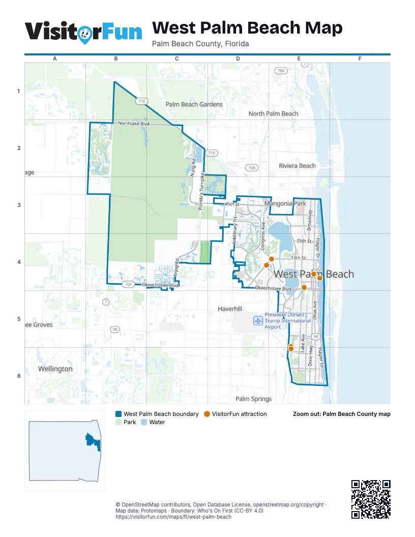
Street index of West Palm Beach
Each street on the sheet and the grid squares it crosses.
- Florida's TurnpikeC2, C3, C4
- Okeechobee BoulevardB4, C4, D4, E4
- Palm Beach Lakes BoulevardD4, E4
- South Flagler DriveE4, E5, E6
- South Dixie HighwayE4, E5, E6
- BroadwayE3, E4
- Belvedere RoadE5
- Southern BoulevardE5
- Quadrille BoulevardE4
- Bee Line HighwayC2
- Dixie HighwayE4, E6
- North Dixie HighwayE4
- 25th StreetE4
- Lakeview AvenueE4
- Flagler Memorial BridgeE4
- Royal Park BridgeE4
- 24th StreetE4
- 45th StreetC3, D3, E3
- Northlake BoulevardB2, C2
- North Jog RoadC2, C3, C4
- North Australian AvenueE3, E4
- North Military TrailD3, D4
- South Australian AvenueE4, E5
- Olive AvenueE4, E5, E6
- Forest Hill BoulevardE6
- Greenwood AvenueE3, E4
- Australian AvenueE5
- Village BoulevardD3, D4
- North Flagler DriveE3, E4
- Georgia AvenueE5, E6
- Parker AvenueE4, E5, E6
- North Congress AvenueD3, D4, E4
- South Olive AvenueE4, E5
- Haverhill RoadD2, D3, D4
- Cumberland DriveD3
- North Tamarind AvenueE4
- Roebuck RoadC4, D4
- Washington RoadE5, E6
- Executive Center DriveD4, E4
- Congress AvenueD3
- 36th StreetE3
- Saratoga RoadD3, D4
- Old Okeechobee RoadE4, E5
- Shenandoah RoadD4
- Shiloh DriveD3
- Banyan BoulevardE4
- Mercer AvenueE5
- Centrepark BoulevardE5
- Gregory RoadE6
- Nottingham BoulevardE5
- North Olive AvenueE4
- North State Road 7B2
- Summit BoulevardE6
- Fern StreetE4
- Poinsettia AvenueE3, E4
- Maddock StreetE6
- South Tamarind AvenueE4
- South Congress AvenueD4, E4
- Bunker RoadE6
- North Florida Mango RoadE4, E5
- Spencer DriveD4
- 59th StreetE3
- Worthington RoadE5
- Church StreetE4
- Community DriveD4
- Benoist Farms RoadC4
- Skees RoadC4
- Perimeter RoadE5
- Lakeside Green BoulevardD4
- Jog RoadC4
- James L Turnage BoulevardE5
- Sansburys WayB4
- North Benoist Farms RoadC4
- Riverwalk CircleC4
- Spruce AvenueE3, E4
- Lake AvenueE5, E6
- Sandhill Way EastB2
- Sandhill Way WestB2
- Embassy DriveD3, E3, D4, E4
- Baywinds DriveB4
- Pinewood AvenueE3, E4
- Windsor AvenueE3, E4
- Ibis BoulevardB2
- Hillcrest Memorial Park CemE6
- 7th StreetE4
- Grande BoulevardB2, B4
- Brandywine RoadD4
- Florida AvenueE4, E5
- Garden AvenueE5, E6
- 8th StreetE4
- Division AvenueE4
- Portofino WayD3
- 6th StreetE4
- 9th StreetE4
- 13th StreetE4
- Ironhorse BoulevardC2
- 27th Court NorthD4
- Dreher Trail NorthE5, E6
- 42nd StreetE3
- 39th StreetE3
- 10th StreetE4
- 43rd StreetE3
- 11th StreetE4
- Green Pine BoulevardD4
- Presidential WayD4, E4
- 40th StreetE3
- 54th StreetE3
- Northpoint ParkwayD3
- Sunset RoadE5
- 15th StreetE4
- Audubon Trace WestB2, B3
- 44th StreetE3
- Lakes BoulevardB2
- Northwood University DriveD4
- North Sapodilla AvenueE4
- Lake Tahoe CircleD3, D4
- Palmetto StreetE6
- Catalina Centre North DriveD3, D4
- Macy StreetE6
- Saratoga Bay DriveD3, D4
- Brevard AvenueE6
- Upland RoadE5
- Norton AvenueE6
- 30th StreetE4
- Andros IsleB4
- 27th StreetD4, E4
- Bear Island DriveD4
- North Mangonia DriveE4
- Webster AvenueE5, E6
- 23rd StreetE4
- 35th StreetE3
- 37th StreetE3
- South Lake AvenueE5, E6
- 31st StreetE3
- Lytle StreetE6
- Douglas AvenueE4
- Martin AvenueE6
- 26th StreetE4
- Bear Lakes CourtD4
- 29th StreetE4
- Hillcrest BoulevardE5
- 33rd StreetE3
- Ardmore RoadE5
- Churchill RoadE6
- San Marino BoulevardD3, D4
- Celebration BoulevardC4
- Tecumseh DriveD3, D4
- 34th StreetE3
- Flamingo DriveE5
- Golf AvenueE4
- Caribbean BoulevardD3
- Datura StreetE4
- Hampton RoadE5
- Hunter StreetE6
- 32nd StreetE3
- 14th StreetE4
- Clematis StreetE4
- Wildcat RunB3
- Valley Forge RoadE6
- Colonial RoadE6
- Evernia StreetE4
- 3rd StreetE4
- North Rosemary AvenueE4
- Riverwalk BoulevardC4
- 21st StreetE4
- Nathan Hale RoadE6
- Franklin RoadE6
- Whitehall DriveD3
- Chagall CircleD4
- Avon RoadE5
- North Shore DriveE3
- Earnest StreetC4, D4
- Bay Harbour CircleB4
- 20th StreetE4
- Winters StreetE6
- Palmbrooke CircleD3
- Electronics WayE3, E4
- Summa StreetE6
- Victoria CircleD3
- Dreher Trail SouthE6
- Forum PlaceE4
- 19th StreetE4
- Loring DriveD3
- East AvenueE3
- Monroe DriveE5
- East Lakewood RoadE5, E6
- Bay Point CircleB4
- 28th StreetE4
- Clare AvenueE5
- Hawks Landing DriveB2
- Conniston RoadE5
- San AndrosB4
- Pinehurst DriveD3, E3
- Lantern Bay CircleB4
- 4th StreetE4
- Hank Aaron DriveE4
- Ware DriveD4, E4
- Corporate WayD3
- Omar RoadE5
- Plymouth RoadE6
- South Mangonia CircleE4
- Egret Meadow LaneB2
- Easley DriveD3, C4
- 38th StreetE3
- Exchange CourtD4
- 49th StreetE3
- Hamilton KeyC4
- Victoria PointB4
- 5th StreetE4
- Turtle CoveC4
- South Chillingworth DriveD4, E4
- McIntosh StreetE6
- Green StreetE5, E6
- Hansen StreetE6
- Banyan Resort WayD4, E4
- The Pointe DriveD4
- Almeria RoadE5
- Arlington RoadE6
- South Sapodilla AvenueE4
- 22nd StreetE4
- Sandy CayB4
- Francis StreetE5
- Monceaux RoadE5
- Pine CayB4
- Woodstock DriveD4
- El Camino RealD3
- Cranes Pointe WayB2
- Gardenia StreetD4, E4
- North Mangonia CircleE4
- West Lakewood RoadE5
- Henrietta AvenueE4
- Malibu Bay DriveD4, E4
- Torres CircleD4
- Puritan RoadE6
- Centrepark Drive EastE5
- Palm StreetE5
- 41st StreetE3
- El VedadoE5
- Egret Lakes LaneB2
- Park PlaceE5
- Selkirk StreetE6
- Pilgrim RoadE6
- Alhambra PlaceE6
- Claremore DriveE5
- South Heritage WayD3
- Allendale RoadE5
- Australian CourtE3
- Egret Pointe LaneB2
- 52nd StreetE3
- South Sequoia DriveD4
- Heritage Village DriveD3
- 53rd StreetE3
- Heath Circle SouthD3
- Alabama AvenueE4, E5
- Kanuga DriveE5
- Osprey TraceB2
- Tradition Cove Lane EastB2
- Murray RoadE5
- Stafford CreekB4
- Malverne RoadE5
- Orchid Reserve DriveB2
- Wilderness RoadD4
- North San AndrosB4
- Ellamar RoadE6
- Willow Pond Road WestD3
- Eastview AvenueE3
- Blue Heron WayB2
- Bollard RoadC4
- Clipper CircleB4
- Edmor RoadE5
- Potter RoadE6
- South Shaker WayD3
- Westview AvenueE3
- 46th StreetE3
- Echo Lake DriveD3, E3
- Indian RoadD4
- 47th StreetE3
- Biscayne DriveE5
- 48th StreetE3
- Bunker Ranch RoadE6
- Ridgeway AvenueE5
- 51st StreetE3
- Heronwood LaneB2
- Clear Lake AvenueE4
- Gregory PlaceE6
- Tigris DriveC4
- Waterford PlaceB2
- Duval AvenueC4
- Russlyn DriveE5
- Manning AvenueE3
- 50th StreetE3
- 55th StreetE3
- Normandy CircleD4
- Dock StreetE5
- Glenmoor DriveD4
- 56th StreetE3
- Briar Bay BoulevardC4
- 57th StreetE3
- 2nd StreetE4
- 58th StreetE3
Things to do on the West Palm Beach map
Places on the map
- AW Dreyfoos School of the Arts
- BAK Middle School of the Arts
- Banyan Cay
- Bear Lakes Country Club
- Bear Lakes Middle School
- Bill Moss Hillcrest Park
- Brightline West Palm Beach
- CityPlace
- Clear Lake
- Conniston Middle School
- Currie Park
- Dreher Park North
- Dreher Park South
- Gaines Park
- Good Samaritan Medical Center
- Grassy Waters Preserve
- Hillcrest Memorial Park
- Howard Park
- Jeaga Middle School
- JFK Medical Center North Campus
- Lake Mangonia
- Lake Point Center
- Lincoln Park
- Mango Grove
- Nora District
- Northpoint Pkwy Pond
- Palm Beach Outlets
- Phipps Park
- Rinker Athletic Campus
- Saint Mary's Medical Center
- SWA Greenway Trail System
- Tanger Outlets Palm Beach
- The Club at Ibis
- The Jerome Golden Center for Behavioral Health
- The Park West Palm
- The Preserve at Ironhorse
- The Shops at Palm Coast
- Torquise Necklace Greenway
- Torquise Necklace Greenway, M-Canal
- Winding Waters Natural Area
Next to West Palm Beach
© OpenStreetMap contributors, Open Database License, openstreetmap.org/copyright · Map data: Protomaps · Boundary: Who's On First (CC-BY 4.0)















