

Iowa map
Davenport map
About 100,938 people live here (Census Bureau, 2024 estimate). The sheet's index lists 300 streets; West Kimberly Road, West River Drive and Northwest Boulevard cross the most grid squares. Things to do inside the boundary: Figge Art Museum, Putnam Museum and Vander Veer Botanical Park.
Open the map (PDF, US Letter)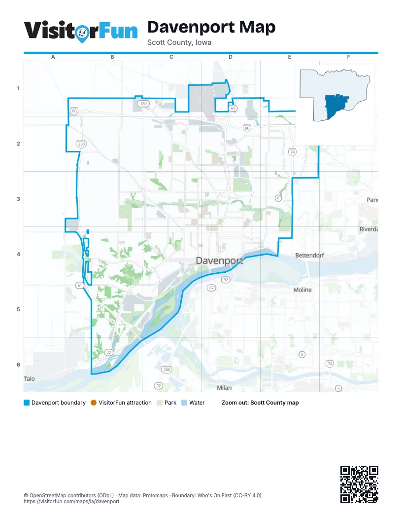
Street index of Davenport
Each street on the sheet and the grid squares it crosses.
- Brady StreetD2, D3, D4
- North Brady StreetD1, D2
- West Kimberly RoadA2, B2, B3, C3, D3
- West River DriveC4, D4, A5, B5, C5
- Rockingham RoadC4, B5, C5, B6
- Northwest BoulevardB1, C1, C2, D2, D3
- East Kimberly RoadD3, E3
- Harrison StreetD1, D2, D3, D4
- Gaines StreetD2, D3, D4
- East River DriveD4, E4
- West 2nd StreetC4, D4
- Western AvenueD2, D3, D4
- Brown StreetD2, D3, D4
- Welcome WayD2, D3
- Spruce Hills DriveE3
- 15th StreetD4
- New Liberty RoadB1
- North Division StreetC1, C2, C3, C4
- West Locust StreetB4, C4, D4
- Veterans Memorial ParkwayD2, E2
- Jersey Ridge RoadE1, E2, E3, E4
- East 53rd StreetD2, E2
- North Pine StreetC2, C3, C4
- Eastern AvenueD2, D3, D4
- Marquette StreetC2, C3, C4
- Elmore AvenueE2, E3, E4
- West Central Park AvenueB3, C3, D3
- Research ParkwayC1, D1, D2
- Hillandale RoadC1, C2, C3, C4
- Utica Ridge RoadE1, E2, E3
- East Locust StreetD4, E4
- 210th StreetA1, B1, D1, E1
- Hickory Grove RoadB3, C3, C4
- West 53rd StreetC2, D2
- West 3rd StreetC4, D4
- West 4th StreetC4, D4
- West 83rd StreetB1, C1
- East Central Park AvenueD3, E3
- Forest Grove DriveE2, F2
- Middle RoadE4
- Slopertown RoadC1, D1
- East 90th StreetD1
- Kimberly RoadE3, E4
- 160th StreetA4, B4
- East 52nd StreetD2, E2
- Lakeview ParkwayE2
- East 4th StreetD4
- 165th AvenueD1
- 53rd AvenueE2
- South 1st StreetD1
- 200th StreetA2
- Wisconsin AvenueB1, B2, B3, B4, B5
- South Concord StreetC4, B5, C5, B6
- Telegraph RoadB4, C4
- North Fairmount StreetC1, C2, C3, C4
- West 46th StreetB3, C3, D3
- Kirkwood BoulevardD4, E4
- West Lombard StreetB3, C3, D3
- West 76th StreetA2, C2, D2
- Ripley StreetD2, D3, D4
- Main StreetD2, D3, D4
- Tremont AvenueD2, D3, D4
- Cedar StreetC2, C3, C4
- West 60th StreetA2, B2, C2, D2
- Washington StreetC3, C4
- North Lincoln AvenueC2, C3, C4
- Warren StreetD2, C3, D3, D4
- West 49th StreetB3, C3
- East 46th StreetD3, E3
- West 35th StreetB3, C3, D3
- Iowa StreetD3, D4
- Farnam StreetD3, D4
- Bridge AvenueD3, D4
- Pershing AvenueD3, D4
- Leclaire StreetD3, D4
- West 14th StreetB4, C4, D4
- West 15th StreetC4, D4
- West 59th StreetC2, D2
- East 59th StreetD2, E2
- 110th AvenueA2, A3, A4
- Crow Creek RoadE3
- Chapel Hill RoadB5
- South Utah AvenueB4, B5, B6
- West 9th StreetB4, C4, D4
- East 12th StreetD4, E4
- East 29th StreetD3, E3
- Waverly RoadC4
- Perry StreetD4
- West 37th StreetC3, D3
- East 11th StreetD4, E4
- East 14th StreetD4
- West 39th StreetB3, C3
- Mound StreetD3, D4
- East 15th StreetD4
- West 65th StreetC2, D2
- East 35th StreetD3, E3
- Buffalo AvenueA1, A2
- 118th AvenueA5, B5
- Indian RoadC4, C5
- East 37th StreetD3, E3
- East 36th StreetD3
- Cheyenne AvenueC3
- South Clark StreetC4
- Oneida AvenueD4
- East 3rd StreetD4
- Enterprise WayC1
- Clay StreetC4
- South Buttermilk RoadC1
- Granite WayC1
- Government BridgeD4
- 130th AvenueB1
- East 2nd StreetD4
- South Division StreetC4
- Greenbrier DriveE3
- 180th AvenueD1
- North Utah AvenueB1, B2, B3, B4
- Forest RoadE2, E3, E4
- Credit Island RoadC5
- West 13th StreetB4, C4, D4
- Belle AvenueE2, D3, E3, E4
- Lorton AvenueE2, E3, E4
- Grand AvenueD2, D3, D4
- Wilkes AvenueC2, C3, C4
- Spring StreetD2, D3, D4
- West High StreetB3, B4, C4, D4
- Mississippi AvenueD2, D3, D4
- North Howell StreetC2, C3, C4
- Scott StreetD2, D3, D4
- West 16th StreetB4, C4, D4
- Fairhaven RoadE2, E3, E4
- West Garfield StreetB3, C3, D3
- East 32nd StreetD3, E3
- West 6th StreetC4, D4
- West Pleasant StreetB4, C4, D4
- West 17th StreetC4, D4
- North Zenith AvenueB1, B3, B4, C4
- Kelling StreetC2, C3
- North Elsie AvenueC2, C3, C4
- West 29th StreetB3, C3, D3
- Pacific StreetC2, C3, C4
- North Sturdevant StreetC3, C4
- North Thornwood AvenueC2, C3, C4
- North Clark StreetC2, C3, C4
- North Linwood AvenueC2, C3, C4
- East Pleasant StreetD4, E4
- West 8th StreetC4, D4
- Myrtle StreetD2, D3, C4, D4
- West 7th StreetC4, D4
- Carey AvenueD2, D3, D4
- Arlington AvenueD3, D4
- West 5th StreetC4, D4
- West 12th StreetB4, C4, D4
- West 61st StreetC2, D2
- West Rusholme StreetB3, C3, D3
- East High StreetD4, E4
- West 34th StreetC3
- Sheridan StreetD2, D3
- College AvenueD2, D3, D4
- Vine StreetD2, D3, D4
- West Hayes StreetC3, D3
- North Fillmore StreetC2, C3, C4
- West 51st StreetC2, D2
- Sturdevant StreetC2, C3
- Oak StreetC2, C3, C4
- West 43rd StreetC3, D3
- West Columbia AvenueB3, C3, D3
- Jebens AvenueC2, C3, C4
- West 11th StreetB4, C4, D4
- Boies AvenueC4, B5, C5
- East Garfield StreetD3, E3
- Taylor StreetC2, C3, C4
- East Rusholme StreetD3
- East Columbia AvenueD3, E3
- Lillie AvenueC2, D2, C3, D3, C4
- East 13th StreetD4, E4
- South Fairmount StreetC4, C5
- Wapello AvenueB5, C5
- West 36th StreetC3
- West 63rd StreetC2, D2
- East 39th StreetD3, E3
- North Michigan AvenueC3, C4
- West 58th StreetC2, D2
- Emerald DriveB3, B4
- McClellan BoulevardE4
- West 1st StreetC4
- West 10th StreetB4, C4, D4
- Elm StreetD3, E3
- East 58th StreetD2, E2
- West 38th StreetC3
- West Dover CourtC3, D3
- Fillmore LaneC2, C3, C4
- Davenport AvenueD3, D4
- Madison StreetC2, C3, C4
- West 30th StreetB3, C3, D3
- Fernwood AvenueE3, E4
- North Elmwood AvenueC2, C3, C4
- Colony DriveD2, D3
- West 66th StreetC2, D2
- West 68th StreetC2
- Esplanade AvenueD3, D4
- East 10th StreetD4
- Davie StreetC2, C3, C4
- Fillmore StreetC2, C3, C4
- Fair AvenueD2, D3
- Ricker Hill RoadB5
- Nobis DriveB5, B6
- Volquardsen AvenueC2, C3
- West 57th StreetC2, D2
- Wyoming AvenueB2, B3
- West 67th StreetC2, D2
- West 47th StreetB3, C3, D3
- Duck Creek RoadE3, E4
- East 76th StreetE2, F2
- Appomattox RoadD2
- West 69th StreetC2
- West 55th StreetC2, D2
- McKinley AvenueC4
- North Birchwood AvenueC2, C3, C4
- East Lombard StreetD3, E3
- South Rolff StreetC4, C5
- Enchanted Island RoadB6
- Jefferson AvenueD3, D4
- West 54th StreetC2
- West Lake BoulevardA3, A4
- West 31st StreetC3, D3
- East 6th StreetD4
- West 48th StreetC3, D3
- East 31st StreetD3, E3
- Cromwell CircleD2, E2
- West 38th PlaceC3
- East 18th StreetD4, E4
- East 38th StreetD3, E3
- Kenwood AvenueE3, E4
- West 70th StreetC2
- East 60th StreetD2, E2
- Railroad AvenueB5, C5
- West 44th StreetC3, D3
- East 9th StreetD4
- Ridgewood AvenueE3, E4
- Olde Brandy LaneD2
- South Stark StreetB5
- East 30th StreetD3
- South Elsie AvenueC4, C5
- Washington LaneC3, C4
- North Gayman AvenueC3, C4
- Keota AvenueB5, C5
- 56th Avenue WestE2
- Kimmel DriveB5
- West Beiderbecke DriveC4, D4
- Diehn AvenueC4
- East George Washington BoulevardD3, E3
- Woodland AvenueE2, E4
- South Dittmer StreetC4, C5
- Ridgeview DriveC2
- Winding Hill RoadD3, E3
- North Stark StreetB3, B4
- West 73rd StreetC2
- Jason WayD2
- Homestead AvenueB5, C5
- West 40th StreetC3
- Villa DriveC2
- East 7th StreetD4
- John Fell DriveB5, C5
- Jackson AvenueC4
- Calvin StreetB4
- East Dover CourtD3
- Grand CourtD3
- East 51st StreetE2
- Valley DriveC2
- Nevada StreetC4, C5
- Heatherton DriveC3
- South Vermont AvenueB5, B6
- Hillcrest AvenueE4
- Grove StreetC4
- West 64th StreetC2, D2
- North Blanchard StreetB3, B4
- Sunnyside AvenueB5, C5
- East 48th StreetD3, E3
- East 61st StreetD2, E2
- Duggleby StreetE3, E4
- El Rancho DriveC3
- Ridge DriveC2, C3
- East Denison AvenueD3
- West George Washington BoulevardC3
- North Hancock AvenueC2, C3
- 190th StreetA2
- Oak Brook RoadC2
- West 71st StreetC2
- South Birchwood AvenueC4
- Hobson AvenueB4, C4
- North Hazelwood AvenueC2, C3, C4
- Christie StreetE4
- Shawnee DriveB4
- Schmidt RoadC4, C5
- Emeis Park AvenueB3, B4
- North Nevada AvenueC3, C4
- North Ohio AvenueC3, C4
- Kathleen WayE2
- Oklahoma AvenueB3, B4
- Farragut StreetC4, C5
Things to do on the Davenport map
Places on the map
- Adams Elementary School
- Assumption High School
- Birchwood South
- Blackhawk Garden Park
- Blain's Farm & Fleet
- Bradey Street Sports Complex
- Buese Boat Launch
- Calvary Cemetery
- Centennial Park
- Credit Island Park
- Crow Valley Golf Club
- Davenport Harbor
- Davenport Memorial Park
- Davenport Soccer Complex
- Duck Creek Golf Course
- Duck Creek Park
- Emeis Golf Course
- Fairmont Cemetery
- Fejervary Park
- Flying J Travel Center
- Garfield Park
- Goose Creek Park
- Iowa Soldiers' Orphans' Homes
- Junge Park
- Mississippi Valley Fairgrounds
- Nahant Marsh
- North High School
- NorthPark Mall
- Northwest Park
- Oakdale Memorial Gardens
- Old Schuetzen Park
- Pine Hill Cemetery
- Prairie Heights Park
- Ridgecrest Village
- Rockingham Township
- Senior Star Elmore Place
- Sunderbruch Park
- Veteran's Memorial Park
- Village Shopping Center
- Wood Intermediate School
Next to Davenport
- Bettendorf
- Buffalo
- Milan
- Moline
- Riverdale
© OpenStreetMap contributors, Open Database License, openstreetmap.org/copyright · Map data: Protomaps · Boundary: Who's On First (CC-BY 4.0); Quattroshapes (CC BY 2.0)