

Iowa map
Scott County map
About 175,601 people live here (Census Bureau, 2024 estimate). The sheet's index lists 300 streets; 280th Street, Oak Street and 240th Street cross the most grid squares. Things to do inside the boundary: Figge Art Museum, Iowa 80 Truckstop and Putnam Museum.
Open the map (PDF, US Letter)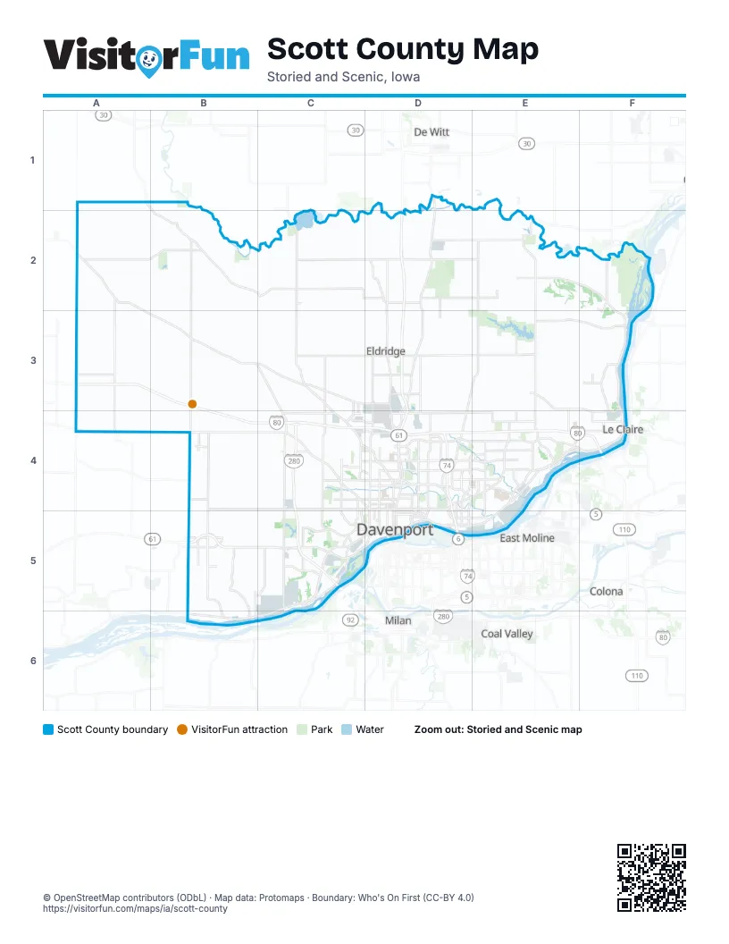
Maps inside Scott County
1 map inside, from the street map of Scott County down.
Street index of Scott County
Each street on the sheet and the grid squares it crosses.
- Brady StreetD4, D5
- North Brady StreetD3, D4
- New Liberty RoadA2, A3, B3, C3, C4
- Great River RoadF2, F3, E4
- West Kimberly RoadC4, D4
- West River DriveC5, D5
- Rockingham RoadC5, D5
- 140th StreetB5, C5
- Northwest BoulevardC4, D4
- South Cody RoadD3, E4, F4
- State StreetE4, D5, E5
- East Kimberly RoadD4
- Harrison StreetD3, D4, D5
- Gaines StreetD4, D5
- Front StreetF4, C5, B6, C6
- Main StreetA2, D2, D4, D5, B6
- Brown StreetD4, D5
- East River DriveD5
- Spruce Hills DriveD4
- West 2nd StreetC5, D5
- Western AvenueA4, D4, D5
- Grant StreetD5, E5
- West Front StreetB6
- Welcome WayD4
- 2nd StreetD2, F3, E4, B6
- River DriveF3, D5
- North Cody RoadF3, F4
- East Front StreetC5
- 15th StreetD5
- 290th StreetA2, B2, C2, D2, E2
- 240th StreetA2, A3, B3, C3, D3, E3
- 210th StreetA4, B4, C4, D4, E4
- 70th AvenueB2, B3, B4, B5
- Scott Park RoadD1, D2, D3, D4
- 200th StreetA4, B4, C4
- 60th AvenueB1, B2, B3, B4
- 300th StreetA2, B2, C2, D2, E2
- 270th StreetA2, B2, C2, D2, E2, F2
- 20th AvenueA2, A3, A4
- Middle RoadD4, E4, D5
- 210th AvenueE2, E3
- 240th AvenueE2, E3
- Territorial RoadE3, F3, F4
- 115th AvenueC2, C3, C5
- North Division StreetD3, D4, D5
- West Locust StreetC4, D4
- Utica Ridge RoadD3, E3, D4
- Veterans Memorial ParkwayD4
- Devils Glen RoadE4, E5
- Jersey Ridge RoadD4, D5
- Bluff RoadE2, F2
- East 53rd StreetD4
- 53rd AvenueD4, E4
- Forest Grove DriveD4, E4
- 162nd AvenueD2, D3
- 160th StreetB4, C4
- Slopertown RoadC3, D3
- North Pine StreetC4, C5
- Eastern AvenueD4, D5
- Elmore AvenueD4, D5
- Hillandale RoadC3, C4, C5
- Marquette StreetD4, D5
- Research ParkwayC4, D4
- Wells Ferry RoadE3, E4
- West Central Park AvenueC4, D4
- South 1st StreetD2, D3
- 267th StreetC2, D2, E2, F2
- Big Rock RoadA1, B1, B2
- Tanglefoot LaneD4, E4
- East Locust StreetD4
- Kimberly RoadD4, D5
- Hickory Grove RoadC4, D4
- West 53rd StreetC4, D4
- West 3rd StreetC5, D5
- West 4th StreetC5, D5
- West 83rd StreetC4
- South Main StreetC2, C3, B4
- East Leclaire RoadD3
- Oak LaneD4, B5, D5
- East Central Park AvenueD4
- Blackhawk Trail RoadD3
- West 1st StreetE2, C5, D5
- 112th StreetB5, B6
- 40th AvenueB2, D4, B6
- North Plainview RoadB3, B4
- Davenport StreetB2, F4
- East 90th StreetD4
- North Main StreetC2, B4
- East Mayne StreetB5
- North 1st StreetD2, D3
- South Mississippi StreetB5
- 285th AvenueD1, F2, F3
- West Leclaire RoadD3
- North Oak LaneB5
- East 52nd StreetD4
- Lakeview ParkwayD4
- South Salina StreetE2
- North Scott Park RoadD3
- East 4th StreetD5
- North Mississippi StreetB5
- East Grove RoadD2
- West Mayne StreetB5
- 165th AvenueD4
- 12th StreetD5
- County Road Y52C2
- East Ives StreetE2
- North Blue Grass RoadB4
- Walcott StreetB2
- North Salina StreetE2
- South Blue Grass RoadB4
- Ives StreetE2
- County Road Y40B2
- 220th StreetA3, B3, C3, D3, E3, F3
- 230th StreetA3, B3, C3, D3, E3, F3
- 280th StreetA1, A2, B2, C2, D2, E2, F2
- 110th AvenueA1, C2, C3, C4, C5
- 230th AvenueE2, E3, E4
- 130th AvenueC2, C3, C4
- Allens Grove RoadB2, C2, C3
- 275th StreetB2, C2, D2
- 220th AvenueE2, E3
- Valley DriveD2, C4, D4, E4, F4, B5
- Wisconsin AvenueC4, C5
- 100th AvenueC4, C5
- South Concord StreetC5
- 190th StreetB4, C4, E4
- 270th AvenueF3, F4
- 235th StreetB3, C3, E3, F3
- Crow Creek RoadD4, E4
- 130th StreetB5, C5
- 18th StreetF2, D4, E4, D5
- 225th StreetE3, F3
- 190th AvenueD2, D3
- Telegraph RoadC5, D5
- North Fairmount StreetC4, C5
- West 46th StreetC4, D4
- 95th AvenueB2, C2, B5, B6
- Coon Hunters RoadB5
- 295th StreetA2, B2
- Maysville RoadC3, C4
- Kirkwood BoulevardD5
- West Lombard StreetC4, D4
- Belmont RoadE4
- West 76th StreetC4, D4
- South Utah AvenueC5
- 257th StreetE3, F3
- Washington StreetB2, F3, D4, D5, B6
- Ripley StreetD4, D5
- Tremont AvenueD4, D5
- 257th AvenueE3, E4
- 277th AvenueF2, F3, F4
- Wisconsin StreetE4, F4
- Cedar StreetC4, C5
- South Buttermilk RoadD3
- Hopewell AvenueE4
- West 60th StreetC4, D4
- North Lincoln AvenueC4, C5
- Warren StreetB4, D4, D5
- Indiana AvenueE4
- West 49th StreetC4, D4
- East 46th StreetD4
- West 35th StreetC4, D4
- North Cadda RoadD2
- 264th StreetE2, F2, F3
- 170th AvenueD2, D3
- East Telegraph RoadB5
- 195th StreetE4
- Iowa StreetD4, D5
- Farnam StreetD4, D5
- Bridge AvenueD4, D5
- Pershing AvenueD4, D5
- Leclaire StreetD4, D5
- Lost Grove RoadF3
- West 14th StreetC5, D5
- West 15th StreetC5, D5
- Holland StreetF4
- 165th StreetB4
- West 59th StreetC4, D4
- East 59th StreetD4
- 23rd StreetD4, D5
- 150th AvenueC2
- Lincoln RoadD4, E4, D5, E5
- Central AvenueD5, E5
- East Lincoln RoadD3
- Chapel Hill RoadC5
- North Buttermilk RoadD3
- Criswell StreetE4
- Mississippi BoulevardD5
- West Lincoln RoadC3, D3
- West 9th StreetC5, D5
- East 12th StreetD5
- Mount Joy AvenueD4, E4
- 29th StreetE4, E5
- East 29th StreetD4
- Waverly RoadC5
- Perry StreetD4, D5
- Greenbrier DriveD4
- West 37th StreetC4, D4
- 14th StreetD4, D5
- East 11th StreetD5
- East 14th StreetD5
- Moencks RoadE4
- 180th AvenueD3, D4
- Maplecrest RoadD4, E4
- West 39th StreetC4, D4
- South 35th Street SouthwestE4
- Dodge StreetF4, B6
- Mound StreetD4, D5
- East 15th StreetD5
- West 65th StreetC4, D4
- Woodland DriveE4, F4
- 118th AvenueC5
- Lincoln StreetB4
- Jefferson StreetB5, B6
- Buffalo AvenueC4
- East 35th StreetD4
- Clay StreetF3, D5
- Indian RoadC5
- East 37th StreetD4
- East 36th StreetD4
- Cheyenne AvenueC4, D4
- 16th StreetD5
- 278th AvenueF2, F3
- Granite WayC3, C4
- Barr StreetE4
- 249th AvenueE4
- South Clark StreetC5
- North 23rd StreetF4
- North 15th StreetF4
- Field Sike DriveE4
- West Telegraph RoadB5
- West Grove StreetD2
- Oneida AvenueD5
- East 3rd StreetD5
- Enterprise WayC4
- West Lauretta StreetB5
- 115th StreetB5, C5
- West Loretta StreetB5
- Government BridgeD5
- East 2nd StreetD5
- South Cadda RoadD2
- 1st AvenueC2
- Barcelona StreetE4
- South Division StreetD5
- 250th StreetC3, D3, E3, F3
- 255th StreetB3, C3, D3
- 200th AvenueD2, D3
- 10th AvenueA1, A2, A3
- 140th AvenueC2, C3
- 80th AvenueB3, B4, B5
- 260th StreetA3, B3, E3
- 90th AvenueB2, B3, B4, B5
- 35th AvenueA2, A3
- Scott County Park RoadD2
- 310th StreetA2, B2, D2, E2
- 305th StreetC2, D2
- 50th AvenueB1, B2, B3
- North Utah AvenueC4, C5
- 265th StreetB2, C2, F2
- 85th AvenueB2, B3
- 97th AvenueC2, C3, C5
- 260th AvenueE2, E3
- 120th AvenueC2, C3, C4
- River Camp RoadB2, C2
- Forest RoadD4, D5
- 30th AvenueA2, A3, A4
- Credit Island RoadC5
- 288th StreetB2, C2
- 145th AvenueC2, C3
- Oak StreetD2, C4, F4, C5, D5, E5, B6
- West 13th StreetC5, D5
- 205th StreetE4, F4
- 315th StreetB1, A2, D2
- Scott StreetA2, B2, D3, D4, D5
- 255th AvenueE2, E3, E4
- Belle AvenueD4, D5
- 145th StreetB5, C5
- 180th StreetB4, C4, E4
- Buena Vista RoadB2
- 247th AvenueE3, E4
- Lorton AvenueD4
- Grand AvenueD4, D5
- 82nd AvenueB2, B4, B5
- Wilkes AvenueD4, D5
- 215th AvenueE3, E4
- Spring StreetD4, D5
- West High StreetC4, D4
- Mississippi AvenueD4, D5
- 170th StreetB4, C4
- North Howell StreetD4, D5
- 283rd AvenueF2, F3
- West 16th StreetC5, D5
- 285th StreetC2, E2
- Fairhaven RoadD4
- West Garfield StreetC4, D4
- East 32nd StreetD4
- Elm StreetD4, F4, E5, B6
- West 6th StreetC5, D5
- West Pleasant StreetC4, D4
- 47th StreetB3
Things to do on the Scott County map
Places on the map
- Allens Grove County Park
- Allens Grove Township
- Bettendorf
- Blue Grass
- Blue Grass Township
- Buena Vista Public User Area
- Buffalo
- Buffalo Township
- Butler Township
- Camp Liberty
- Cleona Township
- Credit Island Park
- Crow Creek Park
- Crow Valley Golf Club
- Davenport
- Davenport Country Club
- Davenport Harbor
- Davenport Plant
- Dixon
- Donahue
- Eldridge
- Emeis Golf Course
- Forest Grove Park
- Glynns Creek Golf Course
- Hickory Grove Township
- Lake of the Hills
- Le Claire
- Le Claire Canal
- Le Claire Township
- Liberty Township
- Lincoln Township
- Long Grove
- Lost Grove Lake
- Lost Grove Lake Wildlife Management Area
- Maysville
- McCausland
- McCausland Wildlife Area
- Mississippi Valley Fairgrounds
- Nahant Marsh
- New Liberty
Next to Scott County
- Coal Valley
- Colona
- De Witt
- East Moline
- Milan
- Moline
- Silvis
© OpenStreetMap contributors, Open Database License, openstreetmap.org/copyright · Map data: Protomaps · Boundary: Who's On First (CC-BY 4.0); Quattroshapes (CC BY 2.0)