

Kansas map
Wichita map
About 400,991 people live here (Census Bureau, 2024 estimate). The sheet's index lists 88 streets; Vietnam Veterans Memorial Highway, North Broadway Street and East 21st Street North cross the most grid squares. Things to do inside the boundary: Botanica, The Wichita Gardens, Exploration Place and Keeper of the Plains.
Open the map (PDF, US Letter)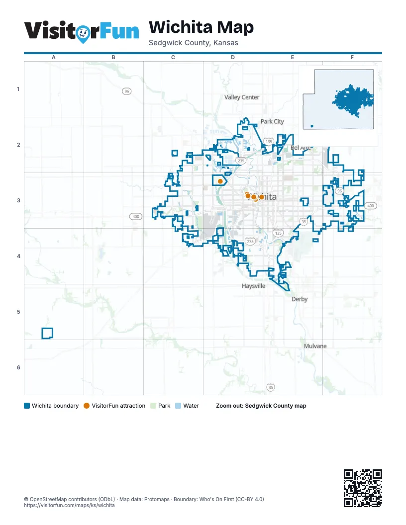
Street index of Wichita
Each street on the sheet and the grid squares it crosses.
- North 103rd Street WestC2
- North Maize RoadC2, C3
- North Tyler RoadC2, C3
- West 29th Street NorthC2, D2
- East 25th StreetD2
- East 25th Street NorthD2, E2
- East 37th Street NorthD2, E2
- North Amidon StreetD2, D3
- North Broadway StreetD2, E2, E3
- North Meridian AvenueD2, D3
- North Ridge RoadD2, D3
- North Womer StreetD2
- West 25th Street NorthD2
- West 53rd Street NorthD2
- East 29th Street NorthE2, F2
- East 39th Street NorthE2, F2
- East 53rd Street NorthE2
- Hillside AvenueE2
- North Hillside AvenueE2
- North Hillside StreetE2, E3
- North Oliver AvenueE2
- North Oliver StreetE2, E3
- North Rock RoadE2, E3
- North Toben StreetE2
- North Woodlawn BoulevardE2, E3
- North Woodlawn StreetE2
- North Greenwich RoadF2, F3
- North Webb RoadF2, F3
- North 119th Street WestC3
- North 135th Street WestC3
- South 119th Street WestC3
- South 135th Street WestC3
- South Maize RoadC3, C4
- South Tyler RoadC3
- Vietnam Veterans Memorial HighwayC3, D3, E3, F3
- West 21st Street NorthC3, D3
- West Central AvenueC3, D3
- West Kellogg DriveC3, D3
- West Kellogg Drive NorthC3
- West Kellogg Drive SouthC3
- West Maple StreetC3, D3
- East 21st Street NorthD3, E3, F3
- East Central AvenueD3, E3, F3
- East Douglas AvenueD3, E3
- East Kellogg DriveD3, E3, F3
- East Pawnee StreetD3, E3, F3
- Eisenhower Airport ParkwayD3
- McLean BoulevardD3
- North Mc Lean BoulevardD3
- North McLean BoulevardD3
- North Seneca StreetD3
- North West StreetD3
- North Westdale DriveD3
- North Westdale StreetD3
- Ridge RoadD3
- South McLean BoulevardD3, D4
- South Meridian AvenueD3, D4
- South Ridge RoadD3
- South Southwest BoulevardD3
- South West StreetD3
- West Douglas AvenueD3
- West Pawnee StreetD3
- West Southwest BoulevardD3, C4, D4
- West Zoo BoulevardD3
- East 13th Street NorthE3, F3
- East 21st StreetE3
- East HarryE3
- East Harry StreetE3, F3
- East Pawnee AvenueE3
- Kansas TurnpikeE3, F3, E4
- North Washington AvenueE3
- South Broadway AvenueE3, E4
- South Hillside AvenueE3, E4
- South Hillside StreetE3, E4
- South Oliver StreetE3, E4
- South Rock RoadE3, E4
- South Southeast BoulevardE3, E4
- South Washington StreetE3
- Southeast BoulevardE3
- Woodlawn StreetE3
- North 127th Street EastF3
- South Greenwich RoadF3
- South Webb RoadF3
- West 21st StreetF3
- West Cessna BoulevardD4
- East 31st Street SouthE4
- East 47th Street SouthE4
- East 63rd Street SouthE4
Things to do on the Wichita map
Places on the map
- Aberdeen
- Academy Park
- Alfred MacDonald Golf Course
- Amarado Estates
- Arthur B. Sim Golf Course
- Arthur B. Sim Memorial Park
- Ashley Park
- Aspen Park Apartments
- Auburn Hills Golf Course
- Audrey Matlock Heights
- Balthrop
- Barefoot Bay
- Barnetts Addition
- Barrington Place
- Beacon Village
- Belle Terre
- Belmont Park
- Benjamin Hills
- Berkshire Apartments
- Blue Lake
- BNSF Wichita Yard
- Bonnie Brae
- Bradford
- Bradley Fair Shopping Center
- Brentwood
- Brentwood Village
- Brookhaven Estates
- Brookhollow
- Brooklyn Heights
- Brooks Landfill
- Bullinger Acres
- Cadillac Lake
- Callahan Addition
- Camber Wichita - Children's Mental Health Hospital
- Camping World
- Carriage Park
- Casey Park
- Cedar Downs
- Cedar Lakes Village
- Cedar Ridge
Next to Wichita
- Bel Aire
- Derby
- Haysville
- Mulvane
- Park City
- Valley Center
© OpenStreetMap contributors (ODbL) · Map data: Protomaps · Boundary: Who's On First (CC-BY 4.0)