

Louisiana map
Baton Rouge map
About 220,907 people live here (Census Bureau, 2024 estimate). The sheet's index lists 222 streets; Airline Highway, Florida Boulevard and Perkins Road cross the most grid squares. Things to do inside the boundary: 13th Gate Escape, Louisiana State Capitol Welcome Center and Louisiana's Old State Capitol.
Open the map (PDF, US Letter)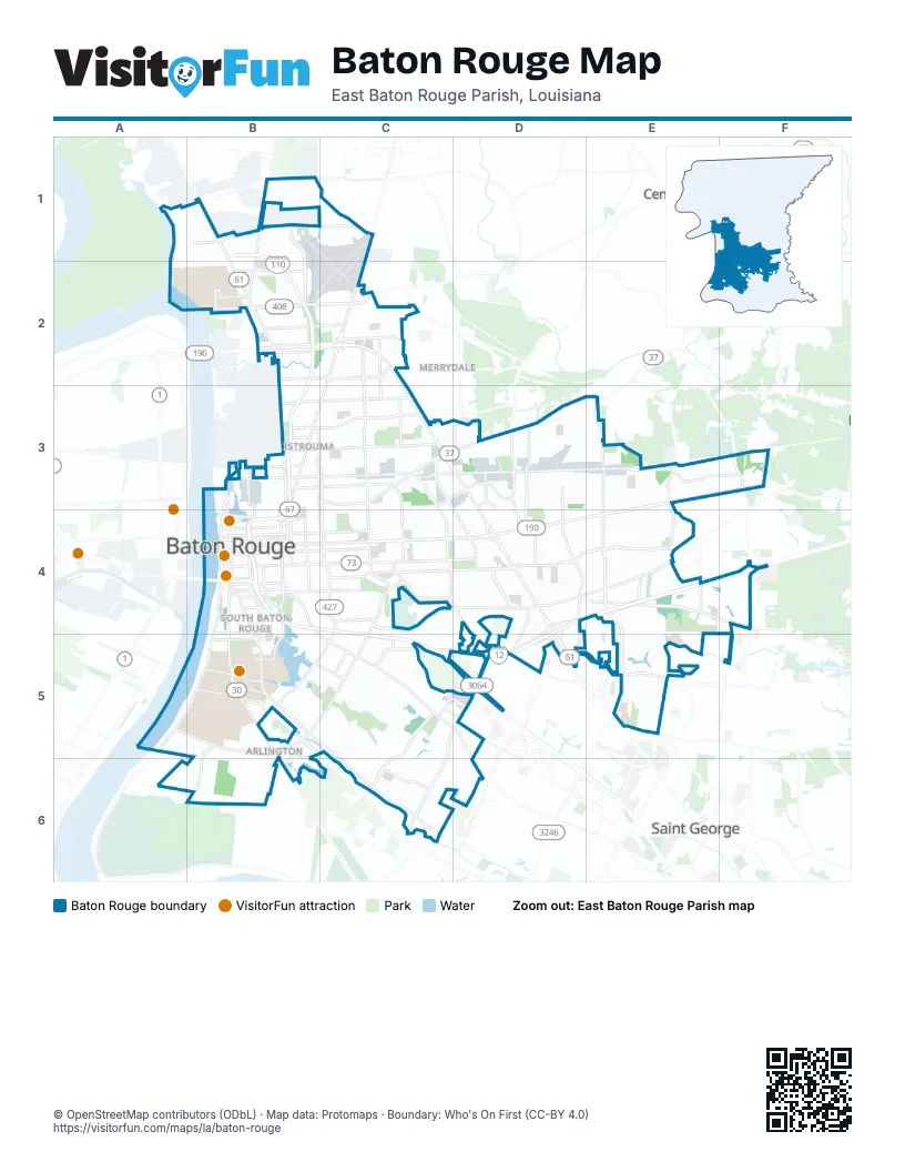
Street index of Baton Rouge
Each street on the sheet and the grid squares it crosses.
- Blount AvenueB1
- Blount RoadB1, C1
- Martin Luther King, Jr. Memorial FreewayB1, B2
- Scenic HighwayB1, B2, B3, B4
- Scotland AvenueB1, B2
- Thomas RoadB1
- Veterans Memorial BoulevardB1, B2
- Plank RoadC1, C2, B3, C3
- 61407B2
- 72nd AvenueB2, C2
- Airline HighwayB2, C2, C3, D3, D4, D5
- East Mason AvenueB2, C2
- F StreetB2
- Farm RoadB2
- Harding BoulevardB2, C2
- Hollywood StreetB2, C2
- Martin Luther King Jr Memorial FreewayB2, B3, B4
- Mason AvenueB2
- Monte Sano AvenueB2, C2
- Rosenwald RoadB2
- Swan AvenueB2
- Beechwood DriveC2
- Dawson DriveC2
- Glen Oaks DriveC2
- Greenwell StreetC2
- Hollywood-Greenwell CrossoverC2
- Hooper RoadC2
- Mc Clelland DriveC2, C3
- McClelland DriveC2
- North Foster DriveC2, C3, C4
- Sumrall DriveC2
- Baton Rouge AvenueB3
- Chippewa StreetB3
- Choctaw DriveB3, C3
- Evangeline StreetB3, C3
- Fairfields AvenueB3, C3
- Gsu RoadB3
- Gus Young AvenueB3, C3
- Hiawatha StreetB3
- Mohican StreetB3, C3
- Nokomis StreetB3
- North 22nd StreetB3, B4
- North 3rd StreetB3, B4
- North Acadian ThruwayB3, C4
- North Acadian Thruway EastB3, C3, C4
- North Acadian Thruway WestB3, C4
- North River RoadB3, B4
- Phlox AvenueB3
- Pocahontas StreetB3
- Sorrel AvenueB3
- West Highway DriveB3, B4
- Winbourne AvenueB3, C3
- Wyandotte StreetB3
- East Brookstown DriveC3
- East Industrial DriveC3
- Greenwell Spgs Road RaC3
- Greenwell Springs RoadC3, D3, E3
- Lobdell BoulevardC3, C4
- Maribel DriveC3
- Mohican-Prescott CrossoverC3
- North Ardenwood DriveC3, C4
- Prescott RoadC3
- South Choctaw DriveC3, D3, E3, F3
- Tom DriveC3, D3
- Wooddale BoulevardC3, D4
- Airway DriveD3, D4
- Harry DriveD3
- Joor RoadD3
- Lanier DriveD3
- Monterrey BoulevardD3, D4
- Monterrey DriveD3
- North Airway DriveD3
- Oak VillaD3
- Oak Villa BoulevardD3, D4
- Sharp LaneD3, D4
- Florida BoulevardE3, F3, C4, D4, E4
- North Flannery RoadE3
- North Sherwood Forest DriveE3, E4
- South Flannery RoadE3, E4
- Central ThroughwayF3
- Central ThruwayF3
- North Stevendale RoadF3
- O Neal LaneF3
- South Stevendale RoadF3
- 3rd StreetB4
- Braddock StreetB4
- Broussard StreetB4, C4
- Capitol Access RoadB4
- Capitol Lake DriveB4
- Dalrymple DriveB4, B5
- East BoulevardB4
- East McKinley StreetB4
- East Washington StreetB4
- Eddie Robinson Senior DriveB4
- Florida StreetB4, C4
- Foss StreetB4
- Fuqua StreetB4
- Government StreetB4, C4
- Highland RoadB4, B5, C5, C6
- Horace Wilkinson BridgeB4
- Louise StreetB4
- Magnolia DriveB4
- Main StreetB4
- McCalop StreetB4
- Myrtle AvenueB4
- Myrtle StreetB4
- Myrtle WalkB4
- Nicholson DriveB4, B5, B6
- North 10th StreetB4
- North 19th StreetB4
- North 27th StreetB4
- North 4th StreetB4
- North 5th StreetB4
- North 9th StreetB4
- North BoulevardB4, C4
- North Eugene StreetB4
- North StreetB4, C4
- North T.J. Jemison BoulevardB4
- Oklahoma StreetB4
- Park BoulevardB4
- Perkins RoadB4, B5, C5, D5, D6
- Saint Charles StreetB4
- Saint Ferdinand StreetB4
- Saint Louis StreetB4
- Saint Philip StreetB4
- South 10th StreetB4
- South 19th StreetB4
- South 22nd StreetB4
- South BoulevardB4
- South Eugene StreetB4
- South River RoadB4, B5
- South T.J. Jemison BoulevardB4
- Spanish Town RoadB4
- St Phillip StreetB4
- State Capitol DriveB4
- T.J. Jemison BoulevardB4
- Terrace AvenueB4
- Thomas H Delpit DriveB4, B5
- West McKinley StreetB4, B5
- Bawell DriveC4
- Claycut RoadC4
- College DriveC4, C5
- Corporate BoulevardC4, D4
- Goodwood AvenueC4
- Goodwood BoulevardC4, D4, E4
- Independence BoulevardC4, D4
- Jefferson HighwayC4, D4, D5, E5
- Lobdell AvenueC4
- South Acadian ThruwayC4, C5
- South Ardenwood DriveC4
- South Foster DriveC4
- Airline Highway Frontage RoadD4
- Cedarcrest AvenueD4, D5
- Connells Park LaneD4
- Cora DriveD4
- Drusilla LaneD4, D5
- East Airport AvenueD4
- Greenmoss DriveD4
- Gwenadelle DriveD4
- Interline AvenueD4, D5
- North Harrells Ferry RoadD4, E4
- Old Hammond HighwayD4, E4
- Plaza Americana DriveD4
- Sam Rushing DriveD4, D5
- Sharp RoadD4
- South Wooddale BoulevardD4
- Southview DriveD4
- Tara BoulevardD4
- West Florida Republic ParkwayD4, E4, F4, C5, D5
- Boulevard de ProvinceE4
- Millerville RoadE4
- Sherwood Forest BoulevardE4
- South Harrell's Ferry RoadE4, F4
- South Sherwood Forest BoulevardE4, E5
- Jones Creek RoadF4, F5
- O'Neal LaneF4
- South Harrells Ferry RoadF4
- Brightside DriveA5, B5
- River RoadA5, B5
- Ben Hur RoadB5, B6
- Burbank DriveB5
- East Fraternity DriveB5
- East Roosevelt StreetB5
- Gourrier AvenueB5
- Hyacinth AvenueB5, C5
- L S U AvenueB5
- Lee DriveB5, C5
- Riverbend BoulevardB5, B6
- Skip Bertman DriveB5
- South Quad DriveB5
- South Stadium DriveB5
- South Stadium RoadB5
- Stanford AvenueB5, C5
- West Lee DriveB5
- West Parker BoulevardB5
- West Roosevelt StreetB5
- Bunker Hill DriveC5
- Congress BoulevardC5
- Constitution AvenueC5
- Dijon DriveC5
- Hennessy BoulevardC5, D5
- Kenilworth ParkwayC5, C6
- One Perkins Place DriveC5
- Picardy AvenueC5, D5
- Staring LaneC5, D5, C6
- Stuart AvenueC5
- Bluebonnet BoulevardD5
- Constantin BoulevardD5
- Costco WayD5
- Coursey BoulevardD5, E5
- Daradele AvenueD5
- Dawnadele AvenueD5
- Essen LaneD5
- North Interstate DriveD5
- Oxford Place DriveD5
- Summa AvenueD5
- Sherwood Common BoulevardE5
- Southpark DriveE5
- Stumberg LaneE5
- Boone AvenueC6
- Gardere LaneC6
- South Staring LaneC6
Things to do on the Baton Rouge map
Places on the map
- 19th Judicial District Courthouse
- 5 East
- Acadian Village
- Anna Jordan Park
- Ardenwood
- Arlington Marketplace
- Artisan Hill
- Audubon Post Office
- Baird Pond
- Banyan Trace
- Baton Rouge
- Baton Rouge Magnet High School
- Baton Rouge Metropolitan Airport
- Beauregard Town
- Belaire High School
- Benjamin Kraft Physical Plant
- Benton
- Bluebonnet Square
- Bocage Shopping Center
- BREC Longridge Park
- BREC Memorial Sports Complex
- Bridge Academy
- Broadmoor Elementary School
- Broadmoor High School
- Broadmoor Shopping Center
- Campus Lake
- Canterbury House Apartments
- Capitol Lake
- Capitol Middle School
- Capitol Stadium
- Capitol View
- Catholic High School
- Catholic Life Center
- Cedarcrest
- Celebration Station
- Citiplace
- City Hall
- City Park Golf Course
- City Park Lake
- City-Brooks Community Park
Next to Baton Rouge
- Central
- Merrydale
- Port Allen
- Saint George
© OpenStreetMap contributors (ODbL) · Map data: Protomaps · Boundary: Who's On First (CC-BY 4.0)