

Louisiana map
West Baton Rouge Parish map
About 28,425 people live here (Census Bureau, 2024 estimate). The sheet's index lists 300 streets; North River Road, South River Road and Highway 1 South cross the most grid squares. Things to do inside the boundary: West Baton Rouge Museum and West Baton Rouge Tourist Information Center.
Open the map (PDF, US Letter)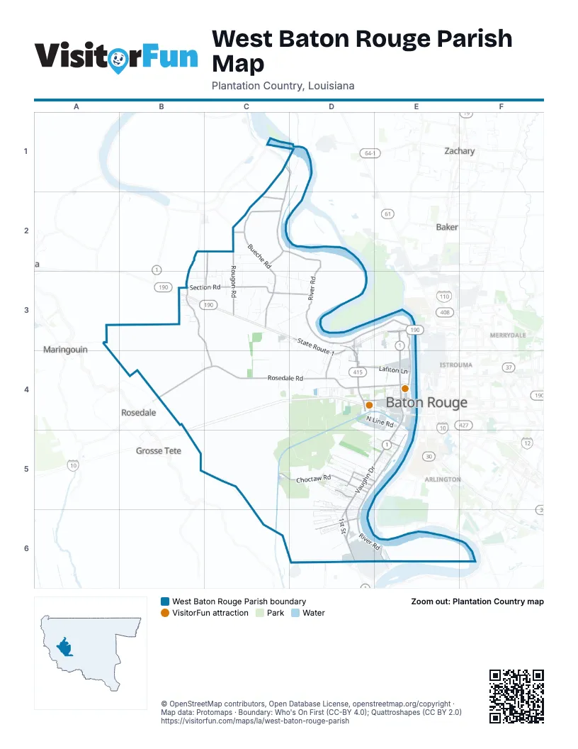
Street index of West Baton Rouge Parish
Each street on the sheet and the grid squares it crosses.
- Horace Wilkinson BridgeE4
- Highway 1 SouthE4, D5, E5, D6
- North Lobdell HighwayD3, D4
- Highway 1 NorthE3, E4
- Airline HighwayE3
- State Route 1D3, D4
- Dr Martin Luther King Jr Memorial HighwayE4
- 1st StreetE4, D5, D6
- Plantation RoadD3, D4
- State Route 415D3
- Highway 1D6
- Lobdell Highway RampD4
- SR 76 RampD4
- North River RoadC1, D1, C2, D2, D3, E3, E4
- Rosedale RoadB4, C4, D4, E4
- South River RoadE4, D5, E5, D6, E6
- Poydras Bayou DriveB2, B3, C3, C4
- Rougon RoadC2, C3
- Court StreetD4, E4
- Calumet RoadD4
- South Kirkland DriveD5, E5
- North Kirkland DriveE5
- Beaulieu LaneE5
- Bueche RoadC2, C3
- Section RoadB3, C3, D3
- Choctaw RoadC5, D5
- Lafiton LaneD4, E4
- Flynn RoadB2, C2, C3
- Main StreetD3, D4, D6
- Lukeville LaneD5
- 6th StreetE4, D6
- Arbroth RoadC2
- Rosehill DriveC2
- Sugar Plantation ParkwayD5
- Avenue GE4
- North Jefferson AvenueE4
- West Main StreetD5
- West Saint Francis StreetD5
- West Bueche RoadC2
- East Main StreetD5, E5
- Addis LaneD6
- East Saint Francis StreetD5
- Kahns RoadD4
- Plantation Avenue LoopD4
- South Labauve AvenueD5
- South Lobdell HighwayD4
- Bridgeside RoadE3
- Poydras Bayou RoadB2
- Enterprise BoulevardD6
- Water Heritage TrailD3, E3, E4
- Westover RoadD4
- I- 10 Frontage RoadD4
- Grand Bayou RoadC3
- Alligator BayouC4, C5, D5
- Ashland RoadC2, C3, D3
- North Line RoadD4, E4
- Emily DriveD5, E5
- South Westport DriveD4, E4
- Commercial DriveD4, E4
- North Vaughn DriveD5, E5
- Smithfield RoadC3, D3
- Florida Gas LaneC3
- South Pacific RoadD4
- Sun Plus ParkwayD4, E4, E5
- Winterville ExtensionC3, D3
- Sid Richardson RoadD6
- Saint Romain RoadC2
- Ernest Wilson DriveE4
- North Alexander AvenueE4
- Rebelle LaneD4
- Allene StreetD5
- Barozza RoadD3, D4
- Live Oak DriveD5
- McLin RoadC2, C3
- Burnside RoadC2
- South Vaughn DriveD5
- Antiono RoadD5, E5
- Louisiana AvenueE4
- Wildwood LaneD1
- Riverside DriveD5, E5
- Ed Lejeune StreetD5, D6
- Union DriveD5
- Bueche RoaddC2
- Landry LaneB3, C3
- American WayD5, E5
- Avenue BE4
- Elm Grove RoadC2, C3
- Live Oak ExtendedD5
- Raymond Labauve DriveD5
- South Winterville RoadC3, D3
- Quarter Horse LaneD5
- Maryland AvenueE4
- Young AvenueC3, D3
- Chenago RoadD6
- Ponderosa LaneD6
- Treuil RoadC3
- Silvery LaneD4
- Myrle DriveD6
- Avenue AE4
- Eudora DriveD6
- Oregon AvenueE4
- Safe Energy DriveE3
- Lee DriveE4, D5
- Orange Grove RoadC3, D3
- Monte Vista DriveD5
- Peter Messina RoadD5, D6
- Sandbar DriveD5
- Clouatre LaneD6
- 7th StreetE4
- 8th StreetE4
- Avenue CE4
- Avenue DE4
- Whitehead BoulevardE4
- California AvenueE4
- Flag LaneD6
- Stonewall DriveD5
- Michigan AvenueE4
- Georgia AvenueE4
- Ory DriveD5
- Little Sister DriveC3
- Vaughn DriveD5, E5
- Triple B Ranch LaneD6
- Laws RoadD6
- Bird Heights AvenueD6
- South Riverview RoadE3
- North Winterville RoadC3
- Plantation Ridge DriveD6
- Andre LaneB2, B3
- Homestead LaneE4
- Foret StreetD6
- Myhand StreetD6
- Antonio RoadE5
- Rev ManuelE5
- Fairview DriveE5
- Boulevard AcadianD5
- Parker LaneE5, D6
- Phillip's LaneE5
- Roseland DriveD4
- Deer LaneD3
- 14th StreetE4
- Faye StreetE4
- Terrill DriveD5, E5
- Pauls LaneD5
- Cherrywood DriveD4
- Cane Ridge DriveD6
- Bellmont RoadD3
- Colonial DriveD4
- Tonawanda StreetC3
- Belmont RoadD3
- Louise DriveD5
- Hugh Loop RoadD3, D4
- Wilbert RoadC4
- Esperanza DriveD4
- Little Hope DriveD5
- Longwood DriveD5
- Patricia AvenueB3
- Swanson RoadC3
- Red Hat LaneD5
- Driftwood LaneD5
- Allendale DriveE4
- Allendale RoadD3, D4
- Webster LaneD4
- East Subdivision RoadB3, C3
- Gremillion RoadD3
- Devin LaneC4
- Pecan StreetB3, D5
- Lansdowne DriveE5
- East Nic DriveD6
- River Park LaneD5
- Borruano AcresD5
- North Palmer LaneB3
- Younger DriveD5, D6
- Olivia DriveD5
- Pecan Grove RoadC3
- Northwest DriveE3
- North 12th StreetE4
- Montrachet DriveD4
- Capital DriveE4
- South Palmer LaneB3
- Sugar Hollow LaneD6
- Hazel LaneD4
- Elizabeth LaneD5
- Sallie DriveD6
- Bohne RoadD4
- Horner RoadC2, C3
- Phillips WayE4, E5
- Russell LaneC3
- Mahaffey RoadE4
- Nolan David RoadD3
- Canal WayE4, E5
- South Jefferson AvenueE4
- Leblanc RoadE4
- Woodland CourtE5
- South Alexander AvenueE4
- East Catherine RoadD3
- Oak Grove LaneC3
- Kentucky AvenueE4
- Black Smith RoadE4
- Chris DriveD6
- Melissa AvenueE4
- Violets LaneD4
- Mayers LaneC2
- Pelican BoulevardD4
- Pete Riviere DriveE4
- Burbridge StreetE4
- Oaks AvenueE4
- Avenue FE4
- Cinclare DriveE4
- River Landing DriveD5
- West Lake DriveD4
- Avenue EE4
- Catherine RoadD3
- Harris StreetD6
- Skunky Williams RoadD4
- Willow StreetB3, E5
- Jaselyn Ann AvenueD5
- Susan Jean DriveD5, D6
- South 14th StreetE4
- Maxine StreetC3
- Pourciau LaneD3
- River Boat LaneD5
- Belle Vue DriveD5
- Larguier LaneD4, E4
- Ena StreetB3
- South 12th StreetE4
- Memory LaneD4
- Cypress StreetB3
- Ida Ln Private DriveD4
- Maple StreetB3
- Catch Pen RoadD4
- Oak AlleyE5
- Tuscaloosa AvenueC3
- Jules LaneD4
- Bourgeois StreetD5, E5
- North Riverview RoadE3
- Bayou Plantation DriveD5
- Harrison LaneC2
- Singleton RoadC3
- Hummingbird LaneC3
- Oak StreetB3
- North 15th StreetE4
- Brantford DriveD4
- Turner RoadD4
- Treuil Landing RoadC4
- Vancouver DriveD4
- Clarkland BoulevardD5
- Poplar Grove DriveD5
- Avery Grace BoulevardD5
- Freeman LaneE5
- Gwin StreetD5, E5
- Higdon LaneC3
- Dibenedetto LaneD3
- Karen DriveD6
- Heliotrope StreetE4
- Florida AvenueE4
- River's Edge DriveD5
- Belle Vale DriveD5
- 4th StreetE4, D6
- Ralph Banks LaneC5
- West Parkway DriveD4
- Primrose LaneC3
- Thomas LaneD5
- Mills LaneE5
- Famco RoadD5
- Lorraine StreetD6
- Mulatto Bend RoadE3
- West Hugh Loop RoadD3
- Byrd AvenueC3
- 3rd StreetE4, D6
- North Labauve AvenueD5
- Aubrey Ann DriveD5
- West Acadian Bayou LaneB4
- Blanchard StreetD4, E5
- Silvio LaneC3
- Benoit DriveD5
- Trey WayE4
- Tres LaneD5
- Tullier LaneD5
- Scale House RoadE4
- Hubert Dupuy StreetD6
- Swede LaneC3
- North 10th StreetE4
- Davis LaneD4
- Cane Bayou RoadC2
- Rue ReviereE5
- Lydia StreetD3
- Safeway DriveE3
- KentuckyE4
- Key Biscayne DriveE4
- Fontenot WayC3
- Key Largo DriveE4
- Benedetto LaneD3
- Holloway RoadE3
- Erwin StreetB3
- Paradise Lakes DriveC3
- Hebert StreetD5
- Elevator RoadE4
- Loup LaneD5
- Rambin DriveD5
- Trail DriveD5
Things to do on the West Baton Rouge Parish map
Places on the map
- 415 South Casino
- 415 South Truck Stop
- Addis
- Addis Post Office
- Alford Cemetery
- Antioch Baptist Cemetery
- Baton Rouge West Inn
- Benedetto's Market Land And Marine
- Benevolent Society Cemetery
- Bergeron's Restaurant
- Brusly
- Brusly High Baseball field
- Brusly High Football field
- Brusly High Running Track
- Brusly Post Office
- Bueche Post Office
- Burger King
- Cato
- Chevron
- Circle K
- City Court of Port Allen
- Comfort Suites Port Allen - Baton Rouge
- Court Street Cafe
- Erwinville Post Office
- La Coste Construction Company Airport
- La1 Truck Stop
- Landen L Alexander Park
- Lobdell Park
- Omni Airport
- Pilot Travel Center
- Port Allen
- Port Allen High School
- Port Allen Lock
- Port Allen Post Office
- Rivoult Memorial Park
- State Capitol Raceway
- U.S. Army Corps of Engineers
- Walmart Supercenter
- West Side Golf Course
Next to West Baton Rouge Parish
- Arlington
- Baker map
- Baton Rouge map
- Brookstown
- Garden District
- Grosse Tete
- Istrouma
- Maringouin
- Merrydale
- Rosedale
- South Baton Rouge
- Zachary map
© OpenStreetMap contributors, Open Database License, openstreetmap.org/copyright · Map data: Protomaps · Boundary: Who's On First (CC-BY 4.0); Quattroshapes (CC BY 2.0)















