

Massachusetts map
Dennis map
About 14,862 people live here (Census Bureau, 2024 estimate). The sheet's index lists 300 streets; East West Dennis Road, Route 6A and Main Street cross the most grid squares. Things to do inside the boundary: The Cape Playhouse, Bass River Kayaks and Paddle Boards and Cape Cod Lobster Cruises.
Open the map (PDF, US Letter)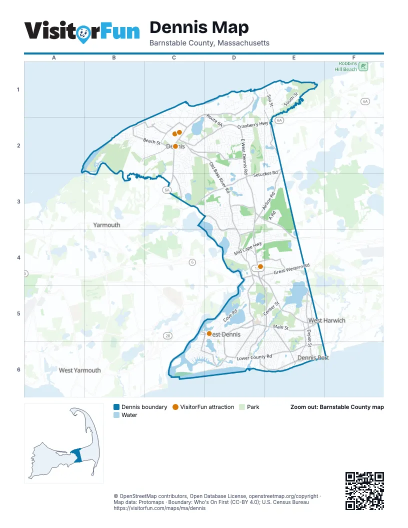
Street index of Dennis
Each street on the sheet and the grid squares it crosses.
- Mid Cape HighwayD4, E4
- East West Dennis RoadD2, D3, D4, D5, E5
- Main StreetD4, C5, D5, E5
- Cranberry HighwayD2, E2
- Old Bass River RoadC2, D2, D3, D4
- Route 6AC1, D1, C2, D2, C3
- Setucket RoadE2, C3, D3, E3
- Lower County RoadD6, E6
- Airline RoadE2, D3, E3
- Upper County RoadD4, E4, E5
- Depot StreetE4, E5, E6
- Mayfair RoadC3, D3, D4
- Great Western RoadD4, E4
- Trotting Park RoadD5, D6
- School StreetE1, E2, D5, D6
- South Yarmouth RoadC3
- Highbank RoadD4
- Bob Crowell RoadD4
- North Dennis RoadC3
- Old Chatham RoadD3, E3, E4
- Sea StreetE1, E5, E6
- Old Wharf RoadD6, E6
- Hokum Rock RoadC2, D2
- Sesuit Neck RoadD1
- Scargo Hill RoadC2, D2
- Shad Hole RoadE5, E6
- Loring AvenueC5, D5, C6, D6
- New Boston RoadB2, C2
- Swan River RoadD5, E5, D6
- Whig StreetC2
- Beach StreetB2, C2
- Telegraph RoadE5
- Shore DriveB2, C2
- Theophilus F Smith RoadD4, E4
- Nobscussett RoadC2
- Old Main StreetD5
- Lighthouse RoadD6
- South Gages WayE4
- Elm StreetC2
- Bay View RoadB2
- Ferry StreetC5, D5
- Depot RoadE5
- Henry Davis CircleD6
- Horse Foot PathB2
- Depot Road WestE5
- Center StreetE1, E4, D5, E5
- South StreetE1, E2, E5
- Cove RoadD5
- West Dennis Beach RoadC6, D6
- Paddocks PathD1, D2
- Greenland CircleD2, E2
- Baxter StreetE5
- Corporation RoadC1, C2
- Captain Chase RoadE5, E6
- Division StreetE5, E6
- Coles Pond DriveE1
- Centre StreetE5
- Pleasant StreetE1, E5, D6, E6
- Uncle Barneys RoadC5, C6
- Forest Hills DriveD2
- Pond StreetC3, D5
- Chapin Beach RoadB2
- Bridge StreetD1, D2
- King James DriveD2
- A RoadE3
- Fisk StreetD5, D6
- Indian TrailE5
- Searsville RoadD4, E4, E5
- Forest Pines DriveD2
- Hemlock LaneD4
- Whittier DriveC2, C3
- Bayridge DriveC3, D3
- Bakers Pond RoadD3, E3
- Sears RoadD2, E2
- Trotters LaneD5, D6
- South Village RoadD6
- Chase AvenueC6, E6, F6
- Barque CircleD2
- Robbins CircleB2, C2
- Cornell DriveE5, E6
- Indian Pond RoadD5, D6
- Taunton AvenueB2
- Cedar Hill RoadD2, E2
- Quivet DriveE2
- Cynthia LaneE5, E6
- Kibby LaneE5, E6
- Signal Hill DriveC2
- Gages WayD3, E3, E4
- Kingswear CircleD3
- Nobscusset RoadC2
- Seaside AvenueC1
- Elizabeth LaneC3, D3
- Winding WayD1
- Prince WayD2
- Old Fish House RoadD4
- Toms PathE5, E6
- Terrace Hill DriveD2
- Bleak House CircleC1
- Siasconset AvenueE5, E6
- Lawrence RoadE5, E6
- Farm LaneD5
- Bradford RoadD2
- Glendon RoadE6
- Michaels AvenueE5, E6
- Lady Slipper DriveD2, D3
- Miramar AvenueD6
- Stephen Phillips RoadD1
- Kings Row DriveD2
- North StreetE1, E5
- Acorn RoadD2, D3
- Old Hills RoadC2
- Scarsdale RoadC1, C2
- Howes PathC2
- Featherbed LaneC2
- Merchant AvenueC6
- Hillside DriveD2
- Uncle Rolf RoadE6
- Edgemere RoadD4
- Charles StreetD3
- Old Mayfair RoadD4
- Pilgrim RoadC2
- Duck Pond RoadD4, E4
- Clipper LaneE5
- Wild Hunter RoadB2, C2
- Polly Fisk LaneE6
- Black Ball Hill RoadC2
- Old Town LaneD1
- Pine StreetD5, E6
- Beaten RoadE6
- Calvin DriveC2
- Buckley RoadC6
- Garfield LaneC6
- Salt Works RoadD1, E1
- Hiram Pond RoadC1, C2
- Sunset LaneD6, E6
- Cassidy AvenueD3
- Little Cove CircleD5
- Sea Meadow DriveD2
- Susan Ruth RoadE6
- Luscombe LaneC2
- Highland RoadD1
- Black Flats RoadB2
- Robbin RunE2
- Country CircleD3, D4
- Surfside RoadC6, D6
- Bristol StreetB2, C2
- Hall StreetC2, E5
- Teal CircleD5, E5
- Rocky Ridge RoadC2
- Cold Storage RoadD1, E1
- Longfellow DriveC2, C3
- Salt Meadows RoadD5, D6
- Asack DriveD3
- Agnes RoadD3
- Bayberry LaneC2, D4, D6, E6
- Harbor RoadD1
- Stafford CircleE5
- Trotting Park Road ExtensionD6
- Cyprus RoadE4
- Crockers PathD1
- Charing Cross RoadD3
- Hope LaneC2
- Jonathan DriveB2, C2
- Martin RoadD3
- Shore RoadC6, D6
- Janall DriveD3
- Ocean DriveE6
- Grassy Pond DriveD3
- North Ocean Grove CircleE6
- Doctor Bottero RoadB2
- Old Chatham Road WestD3
- Highland StreetD1, E4
- Long Hill RoadD2, D3
- Jays DriveD3
- Bayberry RoadD1, D5, D6
- Uncle Bills WayD3
- Union Wharf RoadE6
- Chandler DriveD4, E4
- Duck Pond Road ExtensionD4, E4
- Short Neck RoadD5
- Horsefoot PathB2
- Uncle Bobs WayD3
- Tuckoosa RoadD3
- Lone Tree RoadE5
- Kelleys Pond RoadC6, D6
- Doctor Lords RoadC1, D1
- Mild Bay CircleE4
- East Bayview RoadB2
- Meadowspring DriveD3
- Bain RoadE6
- Lombardi Heights RoadB2
- Jericho RoadC1
- Captain Prestons RoadC3
- Packet DriveC2
- Santucket RoadC6, D6
- South Ocean Grove CircleE6
- Off South StreetE1
- Uncle Stanleys WayD3
- Stillman Kelley RoadE1
- Hazelwood RoadD3
- Northern AvenueD6, E6
- Doctor Stanton RoadC2, D2
- Windsor AvenueD3
- Easy StreetE6
- Jilma DriveD2
- Inman RoadE6
- Madison RoadC3
- Yale CircleE5, E6
- Hippogriffe RoadB2, C2
- Lief Ericson DriveD4
- Wampanoag TrailB2, C2
- Norseman DriveD4
- Croft PathC2
- Indian Field DriveE2
- Pilot DriveE3
- Longell RoadD6
- Apple LaneC2
- Jasmine WayD3, E3
- Thorwald DriveD4
- Timber LaneD3, E3
- Bellgrove RoadD4
- Braddock CircleE3
- Captain Walsh RoadD2, D3
- Settlers LaneD2
- Arrowhead DriveD5
- Simmons Pond West RoadD3
- Baldwin RoadC2
- Shad Bush CircleE2
- Horsefoot RoadD5
- Island StreetE2
- Lorree LaneE6
- Bassett LaneE5, E6
- Dunstable Cross RoadD3
- Winchester DriveE5
- Freydis DriveD4
- Friends LaneD3
- Mooring LaneD2
- Polaris WayE1
- Monument View RoadD2
- Uncle Stephens RoadD6
- Sesuit RoadD1
- Ferncliff RoadE6
- Farrington RoadE1
- Dartmouth RoadD5
- Summer StreetE5, E6
- Judith Ann RoadB2
- Shiverick RoadD1
- Pine RoadD6
- Lora LaneE6
- Mulhern DriveD3, D4
- Chadwick RoadD3
- Dorothy WayD3
- Crown Grant DriveC2
- Debbie LaneD3
- Gold Finch LaneE2
- Davenport RoadC6
- Frank Tobey RoadC2
- Souwest DriveC2, C3
- Farm Hill RoadC2
- Viking DriveD4
- Follins Bay RoadD3, D4
- Davidson AvenueD3
- Northside DriveD2
- Lighthouse Inn RoadD6
- Old Sailors WayD4
- Barry LaneD3
- Lockwood DriveD5
- Pheasant LaneD3
- Oak StreetE6
- Alexander DriveD3
- High Head RoadD2
- Mariner RoadD2
- Aunt Julia Anns RoadD5
- Edwards AvenueE5
- Holiday LaneE6
- Porter LaneC6
- Funn Pond RoadD2
- Sheffield AvenueD3
- Thayer StreetE4
- Openfield RoadD3
- Bayview CircleD4
- Barristers WalkC2
- Candlewood LaneE5
- Trudy CircleD2
- Flax StreetC3
- Obeds LaneD5
- Church StreetD5
- Rhyspah RoadD6
- Captain Howes StreetE1
- West StreetE6
- Aunt Debbys RoadE5
- Coles Pond RoadE1
- Princeton CircleD5
- Wildwood StreetD4
- Federal LaneC2
- Ellis DriveE5, E6
- Cape Colony RoadE3
- Rice LaneC1, C2
- Caleb StreetE6
- Alfred Metcalf DriveC3, D3
Things to do on the Dennis map
Places on the map
- Barbour Land
- Black Ball Hill
- Black Flats Conservation Area
- Cape Cod Landbank Acquisition
- Cape Cod Rail Trail
- Cedar Pond
- Chapin Beach Conservation Land
- Cold Storage Beach
- Coles Pond
- Coles Pond At Crowes Pasture Conservation Area
- Conservation Land/New Boston R
- Conservation Land/W Dennis Rd
- Corporation Beach
- Cross Patch Conservation Area
- Dennis Highlands Golf Course
- Dennis Pines Golf Course
- Flax Pond
- Flax Pond Conservation Land
- Fresh Pond
- Fresh Pond Conservation Area
- Fresh Pond Conservation Land
- George H Chapin Memorial Beach
- Grassy Pond
- Hart Farm
- Indian Lands
- Johnny Kelley Park
- Kellys Pond
- Mayflower Beach
- Mid-Cape Home Centers
- Old Chatham Road RV Resort
- Patriot Square
- Plashes Conservation Land
- Romiq Property
- Scargo Park
- Scargo Pond
- Sears At Crowes Pasture
- South Dennis
- Swan Pond
- West Dennis Beach
- Wilbur Preserve North
Next to Dennis
- South Yarmouth
- West Harwich
- West Yarmouth
- Yarmouth map
© OpenStreetMap contributors, Open Database License, openstreetmap.org/copyright · Map data: Protomaps · Boundary: Who's On First (CC-BY 4.0); U.S. Census Bureau















