

Massachusetts map
Yarmouth map
About 25,208 people live here (Census Bureau, 2024 estimate). The sheet's index lists 300 streets; Main Street, Summer Street and Mid Cape Highway cross the most grid squares. Things to do inside the boundary: Edward Gorey House, Pirate's Cove Adventure Golf and Shark Shark Tuna Fishing Charters.
Open the map (PDF, US Letter)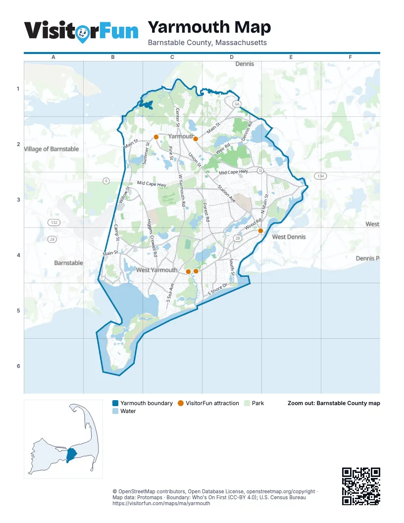
Street index of Yarmouth
Each street on the sheet and the grid squares it crosses.
- Mid Cape HighwayD2, E2, B3, C3, D3
- Main StreetD1, B2, C2, D2, B4, C4, D4, E4
- Willow StreetB2, B3, D4
- Station AvenueD3, D4
- North Main StreetD3, E3, D4
- Union StreetC2, D2, D3, D4, E4
- Bridge StreetD4, E4
- Iyannough RoadB4
- West Yarmouth RoadC2, C3, C4
- Higgins Crowell RoadB3, C3, C4
- Buck Island RoadB4, C4
- Forest RoadC3, D3, D4
- North Dennis RoadD1, D2, E2, E3
- Winslow Gray RoadC4, D4
- Highbank RoadE3
- Long Pond DriveD3, D4
- Wood RoadD3, E3, D4
- Old Town House RoadC3, D3
- Old Main StreetD4
- Camp StreetB3, B4
- Setucket RoadD1, D2, E2
- Great Western RoadE3
- Town Brook RoadB4
- Regional AvenueD3, E3
- Mayfair RoadE2
- Sheridan RoadE3
- Route 6AD1
- Weir RoadC2, D2
- Whites PathE2, D3
- West Great Western RoadD2
- Center StreetC1, C2
- South Shore DriveD4, C5, D5
- South Sea AvenueC4, C5
- White Rock RoadC2
- Pine Grove RoadD4, D5
- South StreetD4
- Baxter AvenueB4
- Silver Leaf LaneC4, C5
- Seaview AvenueC4, C5, D5
- Captain Small RoadD3
- Berry AvenueC4, C5
- Witchwood RoadD3
- Strawberry LaneC2
- Bray Farm Road NorthD1
- Bray Farm Road SouthD1
- Harbor RoadB4, B5
- Bayview StreetB4
- Abells RoadC4
- Cottage DriveC4
- Raymond AvenueD3
- Playground LaneC2
- Park AvenueB4, B5
- Scholl AvenueC4
- Glenwood StreetB4, B5
- Bay View StreetB4
- Highland StreetB4
- Old Church StreetC2
- Somerset StreetB4
- Willow AvenueB4
- Great Island RoadB5, C5, B6
- Summer StreetB2, C2, B3, B4, C4, C5
- Pine StreetC2, D3, C4, C5
- Kings CircuitD1, D2
- Blue Rock RoadE2, E3
- Bakers PathD3, E3
- Pawkannawkut DriveC4, C5
- Pleasant StreetD4, E4
- Cranberry LaneD2, E2, D4
- Springer LaneC4, C5
- Diane AvenueD3
- Thacher Shore RoadB2, C2
- Captain Nickerson RoadD3
- Run Pond RoadD4, D5
- Benjamin WayB3, C3, B4
- Eileen StreetD2
- Webbers PathC3
- Wendward WayB4
- River StreetD4
- Captain Noyes RoadD3
- Ocean AvenueD4, D5
- Wianno RoadD2
- Driftwood LaneD2, E2
- Mayflower TerraceE2
- Mill LaneB2, D4
- Lakefield RoadD3
- Breezy Point RoadD4
- Swan Lake RoadC4, D4
- Workshop RoadC3, D3
- Captain Bacon RoadD3
- Standish WayB4
- Lewis RoadC4, B5, C5
- Indian Memorial DriveD3, D4
- Lookout RoadC1
- Astor WayD3
- Pompano RoadD2
- Merchant AvenueD2
- Sullivan RoadC4
- Quartermaster RowD3
- Wimbledon DriveB4, C4, B5
- Beacon StreetD3
- Crowell RoadC5
- Sea Gull RoadC5
- Clear Brook RoadD4
- Wilfin RoadD4, D5
- Winding Brook RoadD3
- Homers Dock RoadC1
- Evergreen StreetD4
- Traders LaneC4
- German Hill RoadC2, D2, D3
- Valhalla DriveD2
- Buttercup LaneE2
- Cleveland WayB4
- Captain Chase RoadD3
- Knob Hill RoadD2, E2
- Canterbury RoadD1, D2
- Nottingham DriveD1
- Nantucket AvenueD4, D5
- Starbuck LaneC2
- Captain Lothrop RoadD3
- Sisters CircleB2, B3
- Wampanoag RoadC4, D4
- Constance AvenueC3
- Mulford StreetD3
- Pheasant Cove CircleC1
- Curve Hill RoadE3
- Wharf LaneB2
- Captain Besse RoadD3
- Todd RoadE3
- Jefferson AvenueB3
- Studley RoadD3
- Phyllis DriveD3
- Chipping Green CircleE3
- Driving Tee CircleE3
- Pine Cone DriveC4, C5
- Betty's PathC3
- Reagan AvenueB3, B4
- Mid-Tech DriveB3, C3
- Poinsettia DriveD3
- Pond StreetD3, D4
- Country Club DriveE3
- Hemeon DriveC4
- Mattakese RoadC4, C5
- Kates PathD1
- Captain York RoadD3
- Freeman RoadC2, C3
- Heritage DriveC5
- Fairwood RoadE3
- Stratford LaneD1, D2
- Exeter RoadC4, C5
- Winter StreetC2
- Iroquois BoulevardC4, C5
- Lumberjack TrailC3
- Out of Bounds DriveE3
- Coolidge RoadB3, B4
- Massachusetts AvenueC4, B5, C5
- Uncle Roberts RoadB6
- Shaker House RoadC2
- Tanglewood DriveB4, C4
- Barnacle RoadD2
- Keel Cape DriveE3
- Beach RoadC4, C5
- North RoadC4
- Nautical LaneD3
- Salt Box RoadE3
- Trowbridge PathC3
- Alewife CircleD4
- Avon RoadD1, D2
- Nightingale DriveD3
- Longfellow DriveD1
- Beverly RoadC4
- Acres AvenueC4, C5
- Sunset DriveE3, D4
- Mattachee RoadD4, D5
- Taft RoadC3, C4, D4
- Partridge Valley RoadC4
- Blueberry PathD1, C2, D2
- White Cedar RoadB5
- Eldridge RoadD4, D5
- North Sandyside LaneB2, C2
- Captain Weiler RoadD3
- Forest GateD1
- Grandview DriveE3
- Sierra WayD3
- Deb's Hill RoadD2
- Swift Brook RoadD3
- Clifford StreetD4
- Brookhill LaneC4
- Homestead LaneC2
- Ellis CircleC1, C2
- Alms House RoadC1
- Freeboard LaneD2
- Washington AvenueB3
- Collingwood DriveD1
- Adams RoadB3
- Midstream DriveE3
- Holly LaneD4
- Ice House RoadD3, D4
- Old Hyannis RoadC2, B3, C3
- Rita AvenueD3
- Rainbow RoadC5
- Abbott RoadD3
- Hazelmoor RoadD3
- Webster RoadB4
- Melville RoadE3
- Davis RoadD4
- Captain Stanley RoadD3
- Cherry LaneC3
- Monroe LaneC3, D3, C4
- Crowes Purchase RoadC4, C5
- Neptune LaneC4, C5
- Ansel Hallet RoadB3
- Cromwell DriveD1, D2
- Helmsman DriveD2
- Almira RoadD3
- Greenland CircleD2
- Buckwood DriveD3
- Briar CircleD5
- Captain Wright RoadD3
- Parkwood RoadD5
- Hatch RoadD3
- Windjammer LaneD3
- Early Red Berry LaneC2
- Joshua Baker RoadC4
- Haywood AvenueD3
- Lower Brook RoadD3, D4
- Christmas WayD3
- Harbour Hill RunE3
- Colburne PathC3
- Arrowhead DriveC2
- Sibley DriveC4
- West WoodsD1
- Short WayB4
- Camelot RoadC2
- Oak GlenD1, D2
- Ridgewood DriveC2
- Circuit RoadC4, D4
- Seminole DriveC2, D2
- Meadowbrook RoadD4
- Randolph RoadC2
- Marsh Side DriveD1
- Suffolk AvenueC3
- Lyman LaneD4
- Fessenden StreetD3
- Smiths Point RoadB5, B6
- Lake RoadC4, D4
- Danas PathC3
- Boxwood CircleD2
- Shallow Brook RoadD3, D4
- Radio LaneC5
- Norton RoadC4
- Water StreetB2, C5
- Boxberry LaneC4
- Sparrow WayD3
- Howes RoadC4, D4
- Little Dipper LaneD5
- Wilson RoadD3, D4
- Lily Pond DriveE3
- Captain Ryder RoadD3
- Balsam WayC2, C3
- Gunwale WayD2
- Vinebrook RoadD3
- Aft RoadD5
- Pebble Beach WayE3
- Red Jacket RoadC2
- Payson PathC3
- Geneva RoadD3, D4
- Bayberry RoadC5
- Yankee DriveD3
- Cottonwood StreetC2, C3
- Oak AvenueB3
- Horse Pond RoadC4
- Alijo DriveB3, C3, B4, C4
- Amos RoadC4
- Barn Board LaneC4
- Chapel RoadB6
- Nobby LaneC4
- Grouse LaneD4
- McNamara AvenueC3
- Covey DriveD1, D2
- Lakeland AvenueD3, D4
- Commercial StreetD4
- Gordon LaneC2
- Maine AvenueC4, C5
- Lake Road WestC4
- Jills PathC3
- Bog RoadC4
- Bob-O-Link LaneD4
- Brush Hill RoadC2, C3
- Hasting AvenueC3
- Pollock Rip RoadD3
- Captain Dore RoadD3
- Clover RoadC4
- Joel RoadD2
- Whiffletree RoadC4
- Putting Green CircleE3
- Michelles PathC3
- Cove View DriveE3
- Grove StreetB4, D4
- Pamet RoadC4, C5
- Squirrel RunC2
Things to do on the Yarmouth map
Places on the map
- Bass River Golf Course
- Bass River Rod & Gun Club
- Bay View Street Beach
- Bayberry Hills Golf Course
- Big Sandy Pond
- Blizard Land
- Blue Rock Golf Course
- Callery Darling Conservation Area
- Camp Greenough
- Camp Wingate
- Chase Garden Creek WMA
- Dennis Pond
- Dennis Pond Conservation Area
- Dinahs Pond
- Flax Pond Recreation Site
- Follins Pond
- Frank Baker Road
- Great Island
- Greenough Pond
- Horse Pond
- Horse Pond Conservation Land
- Kings Way Golf Club
- Lewis Pond
- Lewis Pond Marsh
- Little Sandy Pond
- Lonetree Creek Conservation Area
- Long Pond
- Mathews Pond
- Perera Property
- Plashes Pond
- Seagull Beach
- Seine Pond
- Skull Island
- Smiths Point
- Syrjala Conservation Area
- Taylor-Bray Farm
- Thatcher Monument
- Water Department Land
- Wellfields 21 & 22
- Yarmouth Port
Next to Yarmouth
- Barnstable map
- Dennis map
- Dennis Port
- Village of Barnstable
- West Dennis
© OpenStreetMap contributors, Open Database License, openstreetmap.org/copyright · Map data: Protomaps · Boundary: Who's On First (CC-BY 4.0); U.S. Census Bureau















