

Massachusetts map
Sandwich map
About 20,507 people live here (Census Bureau, 2024 estimate). The sheet's index lists 300 streets; Mid Cape Highway, Route 6A and Turpentine Road cross the most grid squares. Things to do inside the boundary: Heritage Museums & Gardens, Sandwich Glass Museum and Shawme-Crowell State Forest.
Open the map (PDF, US Letter)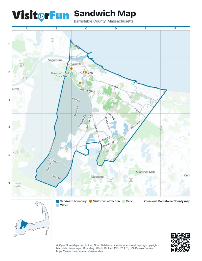
Street index of Sandwich
Each street on the sheet and the grid squares it crosses.
- Mid Cape HighwayB2, C2, C3, D3, E3, E4
- Forestdale RoadC2, C3, C4, C5
- Route 6AB2, C2, D2, D3, E3
- Quaker Meeting House RoadD3, C4, D4
- Old County RoadD3, E3
- Main StreetB2, C2, C4
- Farmersville RoadC4, D4
- Great Hill RoadD4, E4
- Tupper RoadB2, C2
- Chase RoadE3, E4
- Scusset Beach RoadC1
- Water StreetC2
- Jones LaneE3
- Newtown RoadD4, D5
- Race LaneD4
- Beale AvenueC2
- Quaker Meetinghouse RoadD3
- Sandwich RoadB2
- Santuit-Newtown RoadD5
- High StreetE3, C5
- Service RoadC3, D3, E3, E4
- Cotuit RoadC3, C4, C5, D5
- Snake Pond RoadB5, C5
- Pinkham RoadD4
- Harlow RoadD5
- Falmouth-Sandwich RoadC5, B6
- Boardley RoadD4, D5
- Meiggs Backus RoadD5
- Connery AvenueB5
- Sandy Neck RoadE3, F3
- Pimlico Pond RoadC5
- Asa Meiggs RoadD5
- South Sandwich RoadD5
- Howland LaneE3
- Sandwich Cotuit RoadC5
- Asa Meigs RoadD5
- Turpentine RoadB3, B4, A5, B5, A6
- Greenway RoadC3, B4, C4, B5
- Kiahs WayC3, D3, D4
- Gibbs RoadB3, C3
- Barlow RoadC3, C4
- Country Club RoadD4, D5
- South Outer RoadB5, B6
- Popple Bottom RoadD4, E4
- Kittredge RoadA6, B6
- Mill RoadD3, D4
- Chadwick RoadB4, C4
- Generals BoulevardB5, B6
- Stowe RoadD4
- Spring Hill RoadD2, D3
- Herbert RoadB5
- Greenville DriveC4
- John Ewer RoadD4, C5, D5
- Holly Ridge DriveD5
- Grand Oak RoadC4
- Phillips RoadB1, C1
- North Truck RoadB5
- Shawme RoadC2, C3
- Camp Good News RoadB4, C4, C5
- Old Fields RoadD4
- Reflection DriveD5
- Windsor RoadC3, C4
- Foster RoadD2
- North Shore BoulevardD2, E2
- South Inner RoadB6
- West Inner RoadB5, B6
- Torrey RoadE3
- Cranberry TrailE3, F3
- Grove StreetC2
- Ploughed Neck RoadD2, D3
- Village DriveE3
- Discovery Hill RoadD2, D3
- Simpkins RoadB6
- Salt Marsh RoadD2
- Boulder Brook RoadD2
- Knott AvenueC2
- Chipman RoadC2, C3
- Atkins RoadD3
- West Truck RoadB5, B6
- Gully LaneC2, D2, C3
- Moon Compass LaneD5
- Road BB2, C2
- Madison DriveD3
- West Meeting House RoadE3
- South Truck RoadB6
- Woodridge RoadD3, D4
- Buxus Shores CircleC4
- Dillingham AvenueC2
- Artisan WayC5
- Charles StreetC2, C3
- Highfield DriveD4, E4
- East Truck RoadB6
- Kensington DriveC4, D4
- Roos RoadD2
- Jan Sebastian WayC3
- Wood RoadC4
- Oak Ridge RoadD3, E3
- Goat Pasture RoadB3
- East Inner RoadB5, B6
- Hammond RoadE3
- Longhill DriveE3
- Country Farm RoadB5
- Marshview CircleD2, D3
- Anchor DriveC5
- Moody DriveC2
- Road AB2
- East Outer RoadB5, B6
- Tarragon DriveD3, E3, D4
- Road EB2, C2
- Town Neck RoadC2
- Shelton StreetB5
- Carleton DriveE3
- Tyler DriveC2
- Round Hill RoadD3
- Forestdale-Pocasset RoadB4, B5
- Pine StreetC2
- Christopher Hollow RoadC3
- Windswept DriveC2
- Beaman RoadA5, B5
- Crestview DriveD3
- Dolan RoadB5
- Triangle CircleC4
- Great Hills DriveE3
- Blackthorn PathB5
- Southpoint DriveD4
- Lingley AvenueB6
- Crowell RoadC2, C3
- Weaver RoadA5, B5
- Meadow Spring DriveE3
- Open Space DriveD5
- Stonefield DriveD2
- Georgia RdC3
- Conference RdC4
- North Outer RoadB5
- Turtle Cove RoadD4
- Jefferson RoadB3
- Easterly DriveC4
- Pickerel Cove RoadC5
- Pickerel WayC5
- Nauset StreetC4, D4
- Deep Wood DriveB5, C5
- Wolf Hill RoadE3
- Wing Boulevard WestE3
- Osprey LaneD3
- Deer Hollow RoadC5
- Guenther RoadB6
- Morse RoadC2
- Piccadilly RoadC4
- Spinnaker StreetC4, D4
- Van Buskirk WayC4, D4
- Bramblebush DriveC4
- Settlers PathD4
- Wood AvenueC2
- Hampton StreetB5
- Pond View DriveD4
- West Outer RoadB5
- Lakeview DriveD4, E4
- North Inner RoadB5
- Wing Boulevard EastE3
- Robbie RoadC3
- Shaker House RoadC2, C3
- Luscombe LaneD4
- Lee RoadA5, B5, B6
- Richardson RoadB5, B6
- Burge BoulevardB5, C5
- Colonial WayE4
- Ed Moffitt DriveC2
- Norse Pines DriveD2, D3
- Dogwood DriveC4
- Freeman AvenueC2
- Pierre Vernier DriveC5
- Road DB2, C2
- Gaffney StreetB5
- Rockhill RoadC2
- Bourne Hay RoadD5
- President RoadB5
- Oxford RoadD3, D4
- Dewey AvenueC2
- Viking LaneD4, D5
- Beachway RoadE3
- Sconset CircleD5
- Weathervane LaneE3
- Emerald WayB5
- Manor DriveD3
- Dexter AvenueC2
- Lost Meadows RoadE3
- Westerly DriveC4
- Bourne AvenueC2
- Widow Coombs WalkD5
- Fox RunE3
- Faunce Mountain RoadC2
- Meredith RoadB5
- Ridgewood DriveD3, D4
- Quaker Village LaneD3
- Sarah Lawrence RoadD5
- Goose Point LaneE3
- Robin RoadC3
- Prince PathC4
- Parsonage WayC2
- Spectacle RoadD4
- Jarves StreetC2
- Deerwood DriveD3, D4
- Jeannes WayC4, C5
- June LaneD3
- Clipper LaneD5
- Fort Hill RoadE3
- Cedarville RoadD3
- Carman AvenueC2
- Nantucket TrailC4, D4
- Grandwood DriveC4
- Solomon Pond RoadE3
- Fire Arm RoadB5
- Juniper Hill RoadD2
- Jo Jay LaneC4
- J Braden Thompson RoadC5
- Buckingham DriveC4, D4
- Weeks Pond DriveB5
- Highview DriveC2, C3
- Bayview RoadE4
- Windsong RoadC4
- Greenway CircleD5
- Great Island Road.D2
- Pleasantwood DriveC4
- Lakewood DriveD4
- Cardinal RoadC3
- Freedom RoadC5
- Telegraph Hill RoadC3
- Road CB2
- Thicket RunC3
- Hunters TrailD4, D5
- Arnold RoadB4, B5
- Bill Richards DriveC4
- Carolina RdC4
- Powderhorn WayD4, D5
- Dana RoadC5
- Chapaquoit WayD4
- Old Mill RoadD3, E3
- Dukes DriveC3, C4
- Jody LaneB5
- Surrey LaneC3, D3
- Locust LaneE3
- Burbank StreetC2
- Lambeth CircleC4
- Almy AvenueC2
- Shore DriveC5
- Evergreen DriveD5
- Sea Meadow DriveC3, D3
- Tupper AvenueC2
- Jonathan LaneC2
- Scorton Marsh RoadE3
- Checkerberry LaneC4
- Laurel LaneB5
- Shagbark RoadC4
- Fieldstone DriveD3
- Fish House RoadE3
- Pine RoadD2, C5
- Karla LaneE3
- Pinecrest DriveC5
- Toms WayC4
- Atwood StrollD3
- Susan Carsley WayD5
- Captain Wing RoadE3
- Crescent Hill RoadE3, E4
- Fairfield DriveD3, E3
- Nottingham DriveD4
- Woodspring Farm LaneD5
- Cobblestone WayD3
- Brightside LaneC5
- Percival LaneD4, D5
- Tabor RoadC5
- Bradshaw StreetB6
- Lake Shore DriveD5
- Carleton Drive EastE3
- Courtland DriveD3, D4
- Pocasset RoadC2
- Liberty StreetC2
- Chandler RoadE3
- Quaker RoadD2
- Old Snake Pond RoadB5
- Samoset RoadD4
- Morgan TrailC2
- Boardwalk RoadC2
- Guild RoadC5
- Greenhouse RoadB5
- Pin Oak DriveD3, D4
- Shawme AvenueC2
- Freezer RoadC2
- Sandwich Water TowerD4
- Presby Farm LaneE3
- Shaw RoadF3
- Captain Kidd RoadE3
- Captain Teach RoadE3
- Captain Towne RoadE3
- Overlook DriveC3
- Timber WayD4, E4
- Forest RoadB5, C5
- Heather Hill RoadD5
- Gallo RoadC2
- Leveridge LaneC2
- Captain Morgan RoadE3
Things to do on the Sandwich map
Places on the map
- Boardwalk Beach
- Cahoon Property
- Cape Cod Aggregates
- Cape Cod Canal Access
- Cook Farm Conservation Lands
- Cranberry Trail Cranberry Bog
- Falcon Golf Course
- Forestdale School
- Goodell Preserve
- Green Hill Cr
- Heritage Museums & Gardens
- Holly Ridge Golf Club
- ISBC Range
- Landry / Bissonnette Cr
- Lawrence Pond
- Lowell Holly Reservation
- Maple Swamp Conservation Area
- Norse Pines Cr
- Oak Ridge School
- Parsegian Cr
- Peters Pond
- Pimlico Pond
- Pine Hill Conservation Land
- Residential Transfer Station
- Sandwich Fish Hatchery
- Sandwich Game Farm
- Sandwich Hollows Golf Club
- Sandwich Marina
- Sandwich Middle High School
- Sandy Neck Sandwich
- Scusset Beach
- Scusset Beach Campground
- Scusset Beach State Reservation
- Shawme-Crowell State Forest
- Snake Pond
- Spectacle Pond
- The Ridge Club
- Town Neck Beach
- Triangle Pond
Next to Sandwich
- Bourne map
- Marstons Mills
- Mashpee map
- Sagamore
© OpenStreetMap contributors, Open Database License, openstreetmap.org/copyright · Map data: Protomaps · Boundary: Who's On First (CC-BY 4.0); U.S. Census Bureau















