

Michigan map
Detroit-Warren-Dearborn Metro Area map
The sheet's index lists 11 highways; I-94, I-75 and I-96 cross the most grid squares. Things to do inside the boundary: Arab American National Museum, Belle Isle Park and Best Western Premier Detroit Southfield Hotel. Also on it: Dearborn, Detroit and Farmington Hills.
Open the map (PDF, US Letter)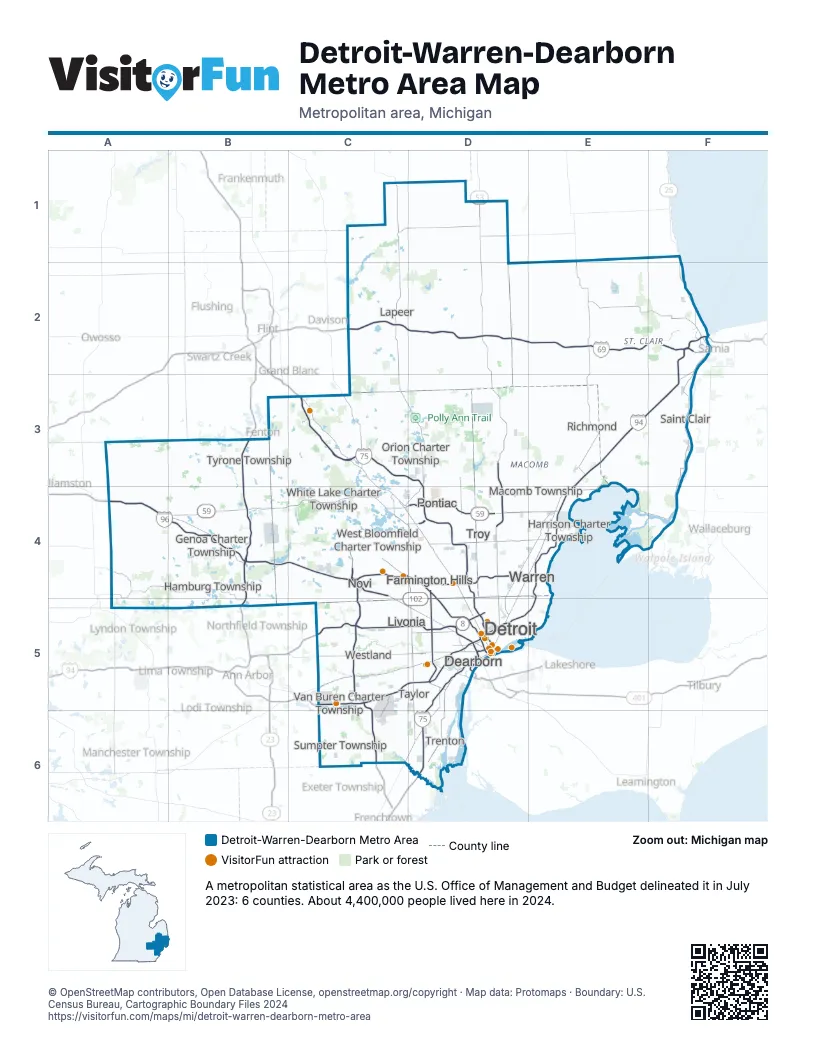
Highway index of Detroit-Warren-Dearborn Metro Area
Each highway on the sheet and the grid squares it crosses.
- I-69C2, D2, E2, F2
- I-75C3, C4, D3, D4, D5, D6
- I-94C5, D5, E3, E4, E5, F2, F3
- I-96A4, B4, C4, C5, D5
- I-275C4, C5, C6
- I-375D5
- I-696C4, D4, E4
- US 12C5
- US 23B3, B4, B5
- US 24C4, D4, D5
- MI 102D4
Things to do on the Detroit-Warren-Dearborn Metro Area map
- Arab American National Museum
- Belle Isle Park
- Campus Martius Park
- Charles H. Wright Museum of African American History
- Comerica Park
- Comfort Inn Detroit Downtown
- Detroit Historical Museum
- Detroit Institute of Arts
- Detroit Princess Riverboat
- Detroit Riverwalk
- Detroit Zoo
- Eastern Market
- Ford Piquette Avenue Plant
- Ford Rouge Factory Tour
- Fort Pontchartrain Detroit, a Wyndham Hotel
- Fox Theatre
- Greenfield Village
- Hilton Garden Inn Detroit-Southfield
- Holiday Inn Express & Suites Belleville (Airport Area)
- Hollywood Casino at Greektown
- Hotel Saint Regis
- Kensington Metropark
- Lafayette Greens
- MGM Grand Detroit
- Michigan Flight Museum
- Michigan Renaissance Festival
- Michigan Science Center
- MotorCities National Heritage Area
- MotorCity Casino Hotel
- Motown Museum
- Museum of Contemporary Art Detroit
- Polish Art Center
- Somerset Collection
- Southland Center
- The Henry Ford
- The Zekelman Holocaust Center
- Thomas Edison Depot Museum
- TownePlace Suites Detroit Belleville
- Wolcott Mill Metropark
Places on the map
- Dearborn
- Detroit
- Farmington Hills
- Genoa Charter Township
- Hamburg Township
- Harrison Charter Township
- Lapeer
- Livonia
- Macomb Township
- Novi
- Orion Charter Township
- Pontiac
- Richmond
- Saint Clair
- Sumpter Township
- Taylor
- Trenton
- Troy
- Tyrone Township
- Van Buren Charter Township
- Warren
- West Bloomfield Charter Township
- Westland
- White Lake Charter Township
© OpenStreetMap contributors, Open Database License, openstreetmap.org/copyright · Map data: Protomaps · Boundary: U.S. Census Bureau, Cartographic Boundary Files 2024