

Minnesota map
Burnsville map
About 64,864 people live here (Census Bureau, 2024 estimate). The sheet's index lists 300 streets; Portland Avenue, County Road 5 and Nicollet Avenue South cross the most grid squares. Also on it: Alimagnet Lake, Alimagnet Park and Black Dog Lake.
Open the map (PDF, US Letter)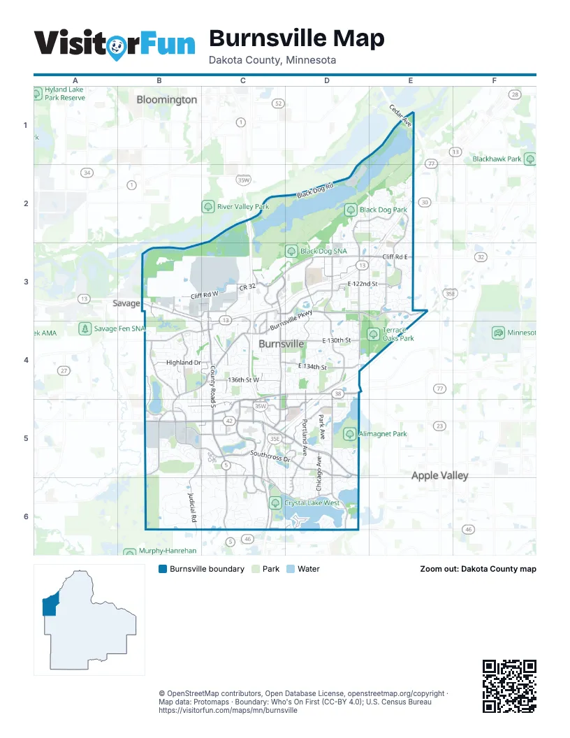
Street index of Burnsville
Each street on the sheet and the grid squares it crosses.
- Cedar AvenueE1
- County Road 42 WestB5, C5
- Portland AvenueD3, D4, D5, D6
- County Road 42 EastC5, D5
- Buck Hill RoadC5, C6
- County Road 42D5
- County Road 5C3, C4, C5, C6
- Cliff Road EastC3, D3, E3
- Nicollet AvenueC3, C4
- McAndrews Road WestC4, C5
- Nicollet Avenue SouthC3, D3, C4, C5
- Williams DriveB4, C4
- East 138th StreetD4
- McAndrews Road EastC4, D4
- 13 Frontage Road NorthB3, C3, C4
- Cliff RoadC3, E3
- 138th Street EastD4
- 160th Street WestD6
- Greenwood DriveC4
- Isleton WayD6
- Diffley RoadE2
- Mc Coll DriveB4
- Southcross DriveB5, C5, D5, D6
- West Burnsville ParkwayB4, C4, B5
- East Burnsville ParkwayD3, E3, C4, D4
- Judicial RoadB4, B5, B6
- Burnhaven DriveC5, C6
- County Road 11D3, D4, D5
- River Hills DriveD2, E2, E3
- Grand AvenueC4, C5, D5, C6
- Parkwood DriveD3, D4
- Maple Island RoadC6, D6
- Aldrich Avenue SouthC4, C5
- Cliff Road WestB3, C3
- Lac Lavon DriveD5, D6
- East 134th StreetC4, D4
- East Travelers TrailC3, D3
- East 130th StreetC4, D4
- Crystal Lake Road EastC6, D6
- 150th Street WestB5, C5, C6
- 136th Street WestC4
- Irving Avenue SouthC4, C5
- Riverwood DriveD3
- 140th Street WestB5, C5
- Southcross Drive WestB5, C5
- East Nicollet BoulevardD4, C5, D5
- Upton Avenue SouthB4
- West Preserve BoulevardB4, B5
- Highland DriveB4, C4
- Kennelly RoadE3
- East 122nd StreetD3, E3
- River Ridge BoulevardC3
- Washburn Avenue SouthB3, B4
- Morgan Avenue SouthB4, C4, B5, C5
- Plymouth AvenueD5
- 12th Avenue SouthD2, D3
- Crystal Lake Road WestC5, C6
- Travelers Trail WestC3, C4
- Southcross Drive EastD5
- Chicago AvenueD5, D6
- River Hills Drive WestD2, D3
- Dupont AvenueC3, C4
- Greenhaven DriveC5, C6
- 143rd Street WestB5, C5
- Evergreen DriveD5
- 126th Street WestB3, C3
- West Frontage RoadC3, C4
- Highway 13 Frontage RoadB3
- CR 32C3
- Pleasant AvenueC3, C4
- Rosemount DriveB5
- Portland Avenue SouthD4, D5
- Highway 13 frontage road southB3
- Burnsville Parkway WestB5
- North Highway 13 Frontage RoadB3
- Fairview DriveD4, D5
- River Hills Drive SouthE3
- West River Hills DriveD3
- Innsbrook LaneD5
- Nicollet Boulevard WestC5
- Chowen Avenue SouthB3
- Westchester SquareD3
- Gateway BoulevardC3, C4
- River Ridge LaneC3
- Frontage RoadE2, B3, B4
- 13 Frontage Road SouthC4
- 145th Street EastC5, D5
- Arthur TerraceC5, D5
- Slater RoadE3
- 141st Street WestB5
- 122nd Street EastD3
- Palomino DriveD4
- Camelot RoadB5
- Civic Center ParkwayC4, D4
- West Black Dog RoadC2, D2, C3
- East Black Dog RoadD2
- Summit Oaks DriveD5
- Oakland DriveD4
- 155th Street WestB6, C6
- Rushmore DriveD6
- Galtier DriveE2, E3
- East 125th StreetD3, E3
- James Avenue SouthC4, C5, C6
- 1st Avenue SouthC4, D4, C5, C6
- Fremont Avenue SouthC4, C5, C6
- Hayes DriveE2
- Loop Road SouthB6
- Penn Avenue SouthB4
- Brookview DriveB4
- 158th Street WestC6
- York AvenueB4, B5
- Sunset Lake DriveB4, B5
- Frontier LaneD4, D5
- Park AvenueB5, D5
- Birnamwood DriveD3
- East 132nd StreetD4
- Shirley DriveB4, C4, C5
- Lacota LaneC4
- Terrace DriveB4, C4
- Westcliffe DriveB5
- Girard Avenue SouthC4
- Allen DriveE3
- Park Avenue SouthD5, D6
- Alimagnet ParkwayD5
- Friendship LaneB5, C5
- Lady Bird LaneC3
- Dana DriveB4
- Summit Shores DriveC5
- Lakeview DriveD4
- Carriage LaneC5, D5
- East 145th StreetD5
- Krestwood DriveC4, D4
- Court PlaceB4
- Woodhill RoadC3, C4
- Bryant Avenue SouthC6
- Valley View DriveB6
- Circle DriveC4
- Orchard DriveC5, C6
- Circle High DriveC6
- Skyline Drive SouthD3, E3
- 117th Street EastE2, D3, E3
- Raleigh DriveD2
- White Oak DriveD5
- Parc DriveE3, E4
- Valley DriveC4
- Corporate Center DriveB5
- Radisson DriveE2
- Aspen DriveD4, B5
- Eagle Ridge DriveD3, D4
- Bluebill Bay RoadD6
- 115th Street EastD2, E2
- Wildwood RoadB5, C5, C6
- Selkirk DriveE3
- Welcome LaneD3, D4
- Highland View Avenue SouthD3, E3
- Tyacke DriveD6
- East 143rd StreetD5
- Oliver Avenue SouthB3, B4
- Knox DriveC4
- 27th AvenueE2
- Apple View LaneD3, D4
- East 131st StreetD4
- Timberland DriveC4
- West Park DriveB5
- East 123rd StreetD3, E3
- Loop Road NorthB6
- Valley High RoadC4
- 157th Street WestC6, D6
- Thomas AvenueB4, B5
- Vincent Avenue SouthB3, B4, B5
- River Woods LaneE3
- Knob Hill RoadC4
- Harold DriveC4
- West 139th StreetC4, B5
- West 132nd StreetB4, C4
- 23rd Avenue SouthE2, D3, E3
- Executive BoulevardC5
- Woods Trail SouthB6
- East 135th StreetC4, D4
- Earle WayC5
- Woodland DriveC4
- Territorial DriveD2, E2
- Oakwood DriveB5
- Pheasant RunD3, D4
- 24th Avenue SouthE3
- Xerxes Avenue SouthB4, B5
- Commonwealth DriveD4
- Viewcrest LaneC5, C6
- Walnut DriveD4
- Thoreau DriveD3, D4
- Crest DriveC6
- Echo Park LaneD4, D5
- Interlachen RoadC5, D5
- East Wellington CrescentC4
- Stevens Avenue SouthD5, D6
- Harriet Avenue SouthC4
- Carver CourtE2
- Humboldt Avenue SouthC4
- Aston CircleD5
- Greenhaven WayC6
- 135th Street WestB4
- Slater LaneC4
- 121st Street EastD3, E3
- Valley View RoadB6
- Larc Industrial BoulevardD3
- Pleasant LaneC4
- Burnsville CircleC6
- Great Oaks DriveD4, E4
- Horizon RoadD3, E3
- Cherry LaneC5, C6
- Heritage Circle NorthC4
- Wellington CrescentC4
- Highpoint CrvD4
- Skyview DriveB4
- Red Oak Circle NorthE3
- 19th Avenue SouthD2
- Arbor LaneC4
- McLeod StreetE2, E3
- Chestnut DriveD5, D6
- Horizon DriveE3
- Crestmount LaneB5
- Keller Lake RoadD6
- Sable DriveE3, E4
- Sunset LaneB4
- Glenview DriveB4
- Upper Wood WayD5
- Steven RoadB4, B5
- Oakland AvenueD5, D6
- 114th Street EastE2
- Parkwood LaneD4
- Villaburne DriveE3
- 4th Avenue SouthD4
- Southwind DriveD6
- River Valley DriveD3
- Old County Road 34 PlaceB4, C4
- Eileen CircleC6
- Geneva BoulevardC5, D5
- 134th Street WestB4
- Burnell Park DriveB5, C5
- White Rock RoadD5
- Rio Loma LaneD3
- Butternut LaneD6
- 16th AvenueD4
- Embassy RoadC3
- Keller Lake DriveD6
- Ewing Avenue SouthB5
- Southpointe CurveC5
- Marcin HillC4, D4
- South 11th AvenueD5
- Heather Hills DriveD4
- Oakwood CurveC4
- Deerwood DriveC5
- Manor DriveB4, C4
- Washburn AvenueB3, B4
- East 140th StreetD5
- Pine Ridge RoadD4
- 151st Street EastC6, D6
- Viking DriveD4
- Boulder DriveB5
- Forest CircleC6
- Beard Avenue SouthB3, B4
- Nicollet LaneC4
- Hillside LaneC5
- Meadow Circle NorthC4
- West 141st StreetB5, C5
- Heritage Circle SouthC4
- Pillsbury AvenueC3, C4
- Rupp DriveD2, D3
- 152nd Street EastD6
- Scenic LaneC6
- Country Wood DriveE3
- Newton AvenueB5, C5
- Interlachen LaneD5
- Earley Shores LaneC5
- Keating AvenueE2
- Lavon LaneD6
- Alcana LaneB6, C6
- Diamond DriveE3, E4
- 2nd Avenue SouthD4
- Schoolcraft RoadD2, E2
- Barbara LaneB4
- 18th AvenueD4
- Black Hills DriveB4, C4
- Unique DriveC4
- Oliver AvenueB4
- Dupont Avenue SouthC4, C6
- Maywood DriveD5
- Longview DriveD4
- Wentworth AvenueC4
- Circle LaneC4
- London DriveE2
- Carriage Pl DriveC5
- Sunny Acres LaneC6
- Foxpoint RoadE2
- Estates TrailC6
- Red Oak Circle SouthE3
- Chicago DriveD5
- Hillshire LaneB5
- Greenridge LaneB5
- Cambridge CourtE2
Places on the map
- Alimagnet Dog Park Pond
- Alimagnet Lake
- Alimagnet Park
- Birnamwood Golf Course
- Black Dog Lake
- Black Dog Park
- Black Dog SNA
- Buck Hill
- Burnsville Center
- Burnsville High School
- Burnsville Quarry
- Cedarbridge Park
- Chateaulin Park
- Civic Center Park
- Colonial Park
- Costco
- Crystal Lake
- Crystal Lake West
- Day Park
- Early Lake
- Fairview Ridges Hospital
- Kelleher Park
- Keller Lake
- Kraemer Lake
- Kruse Lake
- Minnesota River
- Neill Park
- North River Hills Park
- Red Oak Course
- Red Oak Park
- Rudy Kraemer Nature Preserve
- Sue Fischer Memorial Park
- Sunset Pond
- Sunset Pond Park
- Terrace Oaks Park
- Twin Lakes Park
- Waste Management Burnsville Landfill
- Wolk Park
- Wood Park
- Wood Pond
Next to Burnsville
© OpenStreetMap contributors, Open Database License, openstreetmap.org/copyright · Map data: Protomaps · Boundary: Who's On First (CC-BY 4.0); U.S. Census Bureau















